
.gif)
Orange Line (Washington Metro)
Encyclopedia
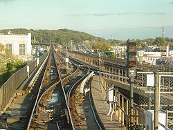
The Orange Line of the Washington Metro
consists of 26 rapid transit
stations
from Vienna to New Carrollton. It has stations in Fairfax County
and Arlington
, Virginia
, the District of Columbia, and Prince George's County
, Maryland
. Half of the line's stations are shared with the Blue Line
, and over two thirds will be shared with the Silver Line
. Orange Line service began on November 20, 1978.
The Orange Line needs 30 trains (9 eight-car trains and 21 six-car trains, consisting of 198 rail cars) to run at peak capacity.
(WMATA).
With the formation of WMATA in October 1966, planning of the system shifted from federal hands to a regional body with representatives of the District, Maryland and Virginia. Congressional route approval was no longer a key consideration. Instead, routes had to serve each local suburban jurisdiction to assure that they would approve bond referenda to finance the system. Because the least expensive way to build into the suburbs was to rely upon existing railroad right-of-ways, the Orange Line took much of its present form, except that it also featured a further extension along the railroad to Bowie, Maryland
and along the Dulles Access Road to the Dulles Airport. By 1966, WMATA and Arlington County planners had agreed "to realign the rapid transit through high-density commercial-office-apartment areas in the vicinity of Wilson Boulevard instead of the freeway's median between the river and Glebe Road."
On March 1, 1968, WMATA approved its Adopted Regional System (ARS) plan that included suburban mass transit lines that followed the median of the proposed Interstate 66
through Virginia to Vienna and the CSX/Amtrak railroad right-of-way in Prince George's County, Maryland. The construction of the downtown Washington sections of the Orange and Blue lines began simultaneously with the Red line. A joint ground breaking ceremony was held on December 9, 1969. Service on the joint downtown track was at first branded as just the Blue Line and commenced on July 1, 1977.
In 1976, Robert Patricelli, federal Urban Mass Transportation Administrator, ordered Metro to conduct an alternatives analysis of the portion of its system that was not already under contract. Because the Tysons Corner area of Fairfax County had developed significantly since the ARS was adopted in 1968, the analysis considered rerouting the Orange line to serve Tysons Corner at an additional cost of $60 million. However, because environmental impact statements had already been completed for the Vienna route, a change in the route would result in a five year delay in the construction of the Orange Line west of Ballston. This prompted the City of Falls Church to sue WMATA for breach of contract. In the end, WMATA kept the Vienna route in tact, leaving Tysons Corner without Metrorail service until 2013.
Service on the Orange Line began on November 20, 1978 between National Airport and New Carrollton, with five new stations being added to the existing network from Stadium–Armory. When the line from Rosslyn to Ballston–MU was completed on December 11, 1979, Orange Line trains began following this route rather than going to the National Airport station. The line was completed on June 7, 1986, when it was extended by four stations to Vienna in the median of I-66.
On January 13, 1982, an Orange Line train derailed
as it was being backed-up from an improperly closed rail switch between the Federal Triangle and Smithsonian stations, resulting in the deaths of three passengers. It was the first incident within the Metro system that caused a fatality, and the deadliest incident occurring in the system until the 2009 collision that resulted in nine fatalities.
until they enter a tunnel under Fairfax Drive just before the Ballston-MU station. Although originally proposed to follow I-66 through Arlington, city planners successfully argued that the line be relocated to Fairfax Drive, which has since stimulated high rise development along the line's route. At the Clarendon station, the tunnel shifts to Wilson Blvd. and 16th Street North. The tunnel then turns north and merges with the Blue Line just before entering the Rossyln station which is located under North Lynn Street. The tunnel continues under the Potomac River
and bends to the east to travel under I Street NW in the District of Columbia.
 The tunnel continues east under I Street and between the Farragut West and McPherson Square stations there is a non-revenue branch track that connect with the Red Line. The tunnel then turns south under 12th Street Northwest and enters the lower level of the Metro Center station. After the Smithsonian station, the tunnel turns east under D Street Southwest and then southeast under Pennsylvania Avenue
Southeast. At the Potomac Avenue station, the tunnel briefly travels under G Street Southeast and then turns northwest under Potomac Avenue with a turn to the north to travel under 19th Street Southeast for the Stadium-Armory station. The tunnel then travels under the RFK Stadium parking lots to surface near Benning Road. The elevated tracks follow Benning Road across the Anacostia River
and then split from the Blue Line. At this point, a pocket rail will be used as the eastern terminus of the Silver Line.
The above ground tracks continue along DC Route 295 between the Minnesota Avenue and Deanwood stations and then follow the CSX/Amtrak railroad in Prince Georges County, Maryland until the eastern terminus at New Carrolton. The route includes a train yard adjacent to the East Falls Church station. Orange Line service travels along the entirety of the K Route (from the terminus at Vienna/Fairfax-GMU to the C & K junction just south of Rosslyn), part of the C Route (from the C & K junction just south of Rosslyn to Metro Center), and the entire D Route (from Metro Center to New Carrollton).
The Dulles Corridor Rapid Transit Project is building a 24 miles (38.6 km) system extension west from East Falls Church, linking Dulles International Airport and Loudoun County
to the system. Other than the new service into Virginia, the Silver Line will operate on the same tracks and serve the same stations as the Orange Line from East Falls Church to Stadium Armory then the Blue Line towards Largo Town Center joins on the same track five stations after the joining of the future Silver Line and the Orange Line at Rosslyn. The Silver Line will terminate at Stadium–Armory, while the Orange line will continue to New Carrollton. Service has been interrupted at stations west of Ballston on designated weekends to accommodate the construction of the interconnection of the Silver Line with the existing Orange Line tracks.
As a part of the Silver Line project, the train yard adjacent to the West Falls Church station on the Orange Line is being expanded, over the objections of local residents. During 2011, older tracks along the Orange Line will be rehabilitated on the weekends.
Washington Metro
The Washington Metro, commonly called Metro, and unofficially Metrorail, is the rapid transit system in Washington, D.C., United States, and its surrounding suburbs. It is administered by the Washington Metropolitan Area Transit Authority , which also operates Metrobus service under the Metro name...
consists of 26 rapid transit
Rapid transit
A rapid transit, underground, subway, elevated railway, metro or metropolitan railway system is an electric passenger railway in an urban area with a high capacity and frequency, and grade separation from other traffic. Rapid transit systems are typically located either in underground tunnels or on...
stations
Metro station
A metro station or subway station is a railway station for a rapid transit system, often known by names such as "metro", "underground" and "subway". It is often underground or elevated. At crossings of metro lines, they are multi-level....
from Vienna to New Carrollton. It has stations in Fairfax County
Fairfax County, Virginia
Fairfax County is a county in Virginia, in the United States. Per the 2010 Census, the population of the county is 1,081,726, making it the most populous jurisdiction in the Commonwealth of Virginia, with 13.5% of Virginia's population...
and Arlington
Arlington County, Virginia
Arlington County is a county in the Commonwealth of Virginia. The land that became Arlington was originally donated by Virginia to the United States government to form part of the new federal capital district. On February 27, 1801, the United States Congress organized the area as a subdivision of...
, Virginia
Virginia
The Commonwealth of Virginia , is a U.S. state on the Atlantic Coast of the Southern United States. Virginia is nicknamed the "Old Dominion" and sometimes the "Mother of Presidents" after the eight U.S. presidents born there...
, the District of Columbia, and Prince George's County
Prince George's County, Maryland
Prince George's County is a county located in the U.S. state of Maryland, immediately north, east, and south of Washington, DC. As of 2010, it has a population of 863,420 and is the wealthiest African-American majority county in the nation....
, Maryland
Maryland
Maryland is a U.S. state located in the Mid Atlantic region of the United States, bordering Virginia, West Virginia, and the District of Columbia to its south and west; Pennsylvania to its north; and Delaware to its east...
. Half of the line's stations are shared with the Blue Line
Blue Line (Washington Metro)
The Blue Line of the Washington Metro in the United States consists of 27 rapid transit stations from Franconia–Springfield to Largo Town Center. It has stations in Fairfax County, Alexandria and Arlington, Virginia, the District of Columbia, and Prince George's County, Maryland...
, and over two thirds will be shared with the Silver Line
Silver Line (Washington Metro)
The Dulles Corridor Metrorail Project, formally dubbed the Silver Line, is an extension of the Washington Metro rapid transit system, currently under construction with the goal of providing rapid transit service to Dulles International Airport and Tysons Corner...
. Orange Line service began on November 20, 1978.
The Orange Line needs 30 trains (9 eight-car trains and 21 six-car trains, consisting of 198 rail cars) to run at peak capacity.
History
Planning for Metro began with the Mass Transportation Survey in 1955 which attempted to forecast both freeway and mass transit systems sufficient to meet the needs of transportation in 1980. In 1959, the study's final report included two rapid transit lines which anticipated subways in downtown Washington. Because the plan called for extensive freeway construction within the District of Columbia, alarmed residents lobbied for federal legislation creating a moratorium on freeway construction through July 1, 1962. The National Capital Transportation Agency's 1962 Transportation in the National Capital Region report anticipated much of the present Orange Line route in Virginia with the route following the median strip of I-66 both inside Arlington and beyond. The route continued in rapid transit plans until the formation of the Washington Metropolitan Area Transit AuthorityWashington Metropolitan Area Transit Authority
The Washington Metropolitan Area Transit Authority is a tri-jurisdictional government agency that operates transit service in the Washington, D.C. metropolitan area, including the Metrorail, Metrobus and MetroAccess...
(WMATA).
With the formation of WMATA in October 1966, planning of the system shifted from federal hands to a regional body with representatives of the District, Maryland and Virginia. Congressional route approval was no longer a key consideration. Instead, routes had to serve each local suburban jurisdiction to assure that they would approve bond referenda to finance the system. Because the least expensive way to build into the suburbs was to rely upon existing railroad right-of-ways, the Orange Line took much of its present form, except that it also featured a further extension along the railroad to Bowie, Maryland
Bowie, Maryland
Bowie is a city in Prince George's County, Maryland, United States. The population was 54,727 at the 2010 census. Bowie has grown from a small railroad stop to the largest municipality in Prince George's County, and the fifth most populous city and third largest city by area in the state of...
and along the Dulles Access Road to the Dulles Airport. By 1966, WMATA and Arlington County planners had agreed "to realign the rapid transit through high-density commercial-office-apartment areas in the vicinity of Wilson Boulevard instead of the freeway's median between the river and Glebe Road."
On March 1, 1968, WMATA approved its Adopted Regional System (ARS) plan that included suburban mass transit lines that followed the median of the proposed Interstate 66
Interstate 66
Interstate 66 is an Interstate Highway in the eastern United States. As indicated by its even route number, it runs in an east–west direction. Its western terminus is at Middletown, Virginia, at an intersection with Interstate 81; its eastern terminus is in Washington, D.C., at an...
through Virginia to Vienna and the CSX/Amtrak railroad right-of-way in Prince George's County, Maryland. The construction of the downtown Washington sections of the Orange and Blue lines began simultaneously with the Red line. A joint ground breaking ceremony was held on December 9, 1969. Service on the joint downtown track was at first branded as just the Blue Line and commenced on July 1, 1977.
In 1976, Robert Patricelli, federal Urban Mass Transportation Administrator, ordered Metro to conduct an alternatives analysis of the portion of its system that was not already under contract. Because the Tysons Corner area of Fairfax County had developed significantly since the ARS was adopted in 1968, the analysis considered rerouting the Orange line to serve Tysons Corner at an additional cost of $60 million. However, because environmental impact statements had already been completed for the Vienna route, a change in the route would result in a five year delay in the construction of the Orange Line west of Ballston. This prompted the City of Falls Church to sue WMATA for breach of contract. In the end, WMATA kept the Vienna route in tact, leaving Tysons Corner without Metrorail service until 2013.
Service on the Orange Line began on November 20, 1978 between National Airport and New Carrollton, with five new stations being added to the existing network from Stadium–Armory. When the line from Rosslyn to Ballston–MU was completed on December 11, 1979, Orange Line trains began following this route rather than going to the National Airport station. The line was completed on June 7, 1986, when it was extended by four stations to Vienna in the median of I-66.
On January 13, 1982, an Orange Line train derailed
1982 Washington Metro train derailment
The 1982 Washington Metro train derailment was an incident involving a single Orange Line Washington Metro train during the afternoon rush hour of January 13, 1982, in Downtown Washington, D.C. in the United States...
as it was being backed-up from an improperly closed rail switch between the Federal Triangle and Smithsonian stations, resulting in the deaths of three passengers. It was the first incident within the Metro system that caused a fatality, and the deadliest incident occurring in the system until the 2009 collision that resulted in nine fatalities.
Route
Starting at its western termini at the Vienna/Fairfax-GMU station in Virginia, the tracks run on the median strip of Interstate 66Interstate 66
Interstate 66 is an Interstate Highway in the eastern United States. As indicated by its even route number, it runs in an east–west direction. Its western terminus is at Middletown, Virginia, at an intersection with Interstate 81; its eastern terminus is in Washington, D.C., at an...
until they enter a tunnel under Fairfax Drive just before the Ballston-MU station. Although originally proposed to follow I-66 through Arlington, city planners successfully argued that the line be relocated to Fairfax Drive, which has since stimulated high rise development along the line's route. At the Clarendon station, the tunnel shifts to Wilson Blvd. and 16th Street North. The tunnel then turns north and merges with the Blue Line just before entering the Rossyln station which is located under North Lynn Street. The tunnel continues under the Potomac River
Potomac River
The Potomac River flows into the Chesapeake Bay, located along the mid-Atlantic coast of the United States. The river is approximately long, with a drainage area of about 14,700 square miles...
and bends to the east to travel under I Street NW in the District of Columbia.
Pennsylvania Avenue
Pennsylvania Avenue is a street in Washington, D.C. that joins the White House and the United States Capitol. Called "America's Main Street", it is the location of official parades and processions, as well as protest marches...
Southeast. At the Potomac Avenue station, the tunnel briefly travels under G Street Southeast and then turns northwest under Potomac Avenue with a turn to the north to travel under 19th Street Southeast for the Stadium-Armory station. The tunnel then travels under the RFK Stadium parking lots to surface near Benning Road. The elevated tracks follow Benning Road across the Anacostia River
Anacostia River
The Anacostia River is a river in the Mid Atlantic region of the United States. It flows from Prince George's County in Maryland into Washington, D.C., where it joins with the Washington Channel to empty into the Potomac River at Buzzard Point. It is approximately long...
and then split from the Blue Line. At this point, a pocket rail will be used as the eastern terminus of the Silver Line.
The above ground tracks continue along DC Route 295 between the Minnesota Avenue and Deanwood stations and then follow the CSX/Amtrak railroad in Prince Georges County, Maryland until the eastern terminus at New Carrolton. The route includes a train yard adjacent to the East Falls Church station. Orange Line service travels along the entirety of the K Route (from the terminus at Vienna/Fairfax-GMU to the C & K junction just south of Rosslyn), part of the C Route (from the C & K junction just south of Rosslyn to Metro Center), and the entire D Route (from Metro Center to New Carrollton).
List of stations
The following stations are along the line, from west to east:| Station | 2009 Boardings | Notes |
|---|---|---|
| Vienna | 13,759 | Western terminus |
| Dunn Loring | 5,304 | |
| West Falls Church | 10,499 | |
| East Falls Church | 4,202 | (future Silver Line Silver Line (Washington Metro) The Dulles Corridor Metrorail Project, formally dubbed the Silver Line, is an extension of the Washington Metro rapid transit system, currently under construction with the goal of providing rapid transit service to Dulles International Airport and Tysons Corner... joins on same track) |
| Ballston–MU | 12,414 | |
| Virginia Square – GMU | 4,067 | |
| Clarendon | 4,355 | |
| Court House | 7,385 | |
| Rosslyn | 16,941 | (Blue Line Blue Line (Washington Metro) The Blue Line of the Washington Metro in the United States consists of 27 rapid transit stations from Franconia–Springfield to Largo Town Center. It has stations in Fairfax County, Alexandria and Arlington, Virginia, the District of Columbia, and Prince George's County, Maryland... joins on same track) |
| Foggy Bottom – GWU | 20,923 | |
| Farragut West | 22,469 | |
| McPherson Square | 17,009 | |
| Metro Center | 30,569 | (Transfer station for Red Line Red Line (Washington Metro) The Red Line of the Washington Metro is a rail rapid transit service operating between 27 stations in Montgomery County, Maryland and the District of Columbia, United States. It is a primary line through downtown Washington, and the oldest and busiest line in the system... ) |
| Federal Triangle | 11,108 | |
| Smithsonian | 12,764 | |
| L'Enfant Plaza | 21,705 | (Transfer station for the Yellow Yellow Line (Washington Metro) The Yellow Line of the Washington Metro consists of 17 rapid transit stations from Huntington to Fort Totten. The line terminates at the Mount Vernon Square station during peak hours.Peak hours are 5 a.m. to 9:30 a.m. and 3 p.m. to 7 p.m. Service is extended to the Green Line stations during... and Green Green Line (Washington Metro) The Green Line is one of five heavy rail subway lines that constitute the Washington Metro rapid transit system in the Washington, D.C., metropolitan area. The Green Line consists of 21 stations, with termini at Branch Avenue and at Greenbelt. The Green Line runs through Prince George's County,... Lines) |
| Federal Center SW | 5,902 | |
| Capitol South | 9,414 | |
| Eastern Market | 6,038 | |
| Potomac Avenue | 4,098 | |
| Stadium–Armory | 3,062 | (Blue Line Blue Line (Washington Metro) The Blue Line of the Washington Metro in the United States consists of 27 rapid transit stations from Franconia–Springfield to Largo Town Center. It has stations in Fairfax County, Alexandria and Arlington, Virginia, the District of Columbia, and Prince George's County, Maryland... splits, and future Silver Line Silver Line (Washington Metro) The Dulles Corridor Metrorail Project, formally dubbed the Silver Line, is an extension of the Washington Metro rapid transit system, currently under construction with the goal of providing rapid transit service to Dulles International Airport and Tysons Corner... ends) |
| Minnesota Avenue | 3,461 | |
| Deanwood | 1,960 | |
| Cheverly | 1,548 | |
| Landover | 2,593 | |
| New Carrollton | 10,118 | Eastern terminus |
Future
The Virginia Department of Transportation (VDOT) announced on Jan. 18, 2008 that it and the Virginia Department of Rail and Public Transportation (VDPRT) had begun work on a draft environmental impact statement (EIS) for the I-66 corridor in Fairfax and Prince William counties. According to VDOT the EIS, officially named the I-66 Multimodal Transportation and Environment Study, would focus on improving mobility along I-66 from the Capital Beltway (I-495) interchange in Fairfax County to the interchange with U.S. Route 15 in Prince William County. The EIS also allegedly includes a four station extension of the Orange Line past Vienna. The extension would continue to run in the I-66 median and would have stations at Chain Bridge Road, Fair Oaks, Stringfellow Road and Centreville near Virginia Route 28 and U.S. Route 29.The Dulles Corridor Rapid Transit Project is building a 24 miles (38.6 km) system extension west from East Falls Church, linking Dulles International Airport and Loudoun County
Loudoun County, Virginia
Loudoun County is a county located in the Commonwealth of Virginia, and is part of the Washington Metropolitan Area. As of the 2010 U.S. Census, the county is estimated to be home to 312,311 people, an 84 percent increase over the 2000 figure of 169,599. That increase makes the county the fourth...
to the system. Other than the new service into Virginia, the Silver Line will operate on the same tracks and serve the same stations as the Orange Line from East Falls Church to Stadium Armory then the Blue Line towards Largo Town Center joins on the same track five stations after the joining of the future Silver Line and the Orange Line at Rosslyn. The Silver Line will terminate at Stadium–Armory, while the Orange line will continue to New Carrollton. Service has been interrupted at stations west of Ballston on designated weekends to accommodate the construction of the interconnection of the Silver Line with the existing Orange Line tracks.
As a part of the Silver Line project, the train yard adjacent to the West Falls Church station on the Orange Line is being expanded, over the objections of local residents. During 2011, older tracks along the Orange Line will be rehabilitated on the weekends.
External links
- world.nycsubway.org: Orange Line