
Maryland Route 384
Encyclopedia
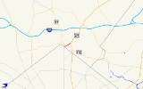
Maryland Route 384 is a state highway
in the U.S. state
of Maryland
. The state highway runs 0.53 mi (0.8529502 km) from MD 390
east to U.S. Route 29
(US 29) and MD 97
within Silver Spring
. MD 384 is the southernmost portion of Colesville Road, a major commuting route and one of the two main streets (along with Georgia Avenue
) within downtown Silver Spring, the commercial hub of southeastern Montgomery County
. The state highway also provides access to the Silver Spring
station of the Washington Metro
, which serves as a transit hub for commuter rail and bus service for the surrounding area.
_looking_e.jpg) MD 384 begins at MD 390 (16th Street) just north of the boundary between Maryland and the District of Columbia. Traffic on southbound MD 390 must travel around the Blair Portal traffic circle
MD 384 begins at MD 390 (16th Street) just north of the boundary between Maryland and the District of Columbia. Traffic on southbound MD 390 must travel around the Blair Portal traffic circle
immediately to the south to access MD 384 from northbound MD 390. MD 384 heads east as a six-lane divided highway between apartment complexes. The development becomes a mix of commercial retail and office buildings at the intersection with MD 410
(East–West Highway). The state highway passes the Silver Spring offices of the National Oceanic and Atmospheric Administration
and the headquarters of the National Weather Service
on the northeast corner of the MD 410 junction. MD 384 continues northeast, passing under a railroad overpass that carries CSX
's Metropolitan Subdivision and the Red Line (Washington Metro)
of the Washington Metro. Pedestrian access to the Silver Spring Metro Station is provided on both sides of the highway. Vehicular access to the transit center—which is also a stop on MARC
's Brunswick Line
and a hub for Metrobus
, Ride On
, and MTA Maryland Commuter Bus service—is provided at the next intersection with Wayne Avenue and Second Street. Shortly after passing the transit center and the headquarters of Discovery Communications
, MD 384 reaches its northern terminus at an intersection with US 29 and MD 97. There are no left turns from Georgia Avenue, which is MD 97 to the north of the intersection and US 29 to the south of the intersection, onto Colesville Road, which continues to the northeast as US 29 north toward Columbia.
in Montgomery County
.
State highway
State highway, state road or state route can refer to one of three related concepts, two of them related to a state or provincial government in a country that is divided into states or provinces :#A...
in the U.S. state
U.S. state
A U.S. state is any one of the 50 federated states of the United States of America that share sovereignty with the federal government. Because of this shared sovereignty, an American is a citizen both of the federal entity and of his or her state of domicile. Four states use the official title of...
of Maryland
Maryland
Maryland is a U.S. state located in the Mid Atlantic region of the United States, bordering Virginia, West Virginia, and the District of Columbia to its south and west; Pennsylvania to its north; and Delaware to its east...
. The state highway runs 0.53 mi (0.8529502 km) from MD 390
Maryland Route 390
Maryland Route 390 is a state highway in the U.S. state of Maryland. The state highway runs from the boundary with Washington, D.C. north to MD 97 in Silver Spring...
east to U.S. Route 29
U.S. Route 29 in Maryland
U.S. Route 29 is a north–south United States highway that runs for from the western suburbs of Baltimore, Maryland, to Pensacola, Florida. In the U.S. state of Maryland, US 29 is a major highway that emerges from Washington D.C. and runs north into eastern Montgomery County, stretching...
(US 29) and MD 97
Maryland Route 97
Maryland Route 97 is a state highway in the U.S. state of Maryland. The route runs from U.S. Route 29 in Silver Spring, Montgomery County north to the Pennsylvania border in Carroll County, where the road continues into that state as Pennsylvania Route 97...
within Silver Spring
Silver Spring, Maryland
Silver Spring is an unincorporated area and census-designated place in Montgomery County, Maryland, United States. It had a population of 71,452 at the 2010 census, making it the fourth most populous place in Maryland, after Baltimore, Columbia, and Germantown.The urbanized, oldest, and...
. MD 384 is the southernmost portion of Colesville Road, a major commuting route and one of the two main streets (along with Georgia Avenue
Georgia Avenue
Georgia Avenue is a major north-south artery in Northwest Washington, D.C. and Montgomery County, Maryland. Within the District of Columbia and a short distance in Silver Spring, Maryland, Georgia Avenue is also U.S. Route 29...
) within downtown Silver Spring, the commercial hub of southeastern Montgomery County
Montgomery County, Maryland
Montgomery County is a county in the U.S. state of Maryland, situated just to the north of Washington, D.C., and southwest of the city of Baltimore. It is one of the most affluent counties in the United States, and has the highest percentage of residents over 25 years of age who hold post-graduate...
. The state highway also provides access to the Silver Spring
Silver Spring (Washington Metro)
Silver Spring is a Washington Metro station in Montgomery County, Maryland on the Red Line. It is the first station in Maryland on the eastern end of the line, and is the most-used Metro station in Maryland. It is co-located with a MARC commuter rail station....
station of the Washington Metro
Washington Metro
The Washington Metro, commonly called Metro, and unofficially Metrorail, is the rapid transit system in Washington, D.C., United States, and its surrounding suburbs. It is administered by the Washington Metropolitan Area Transit Authority , which also operates Metrobus service under the Metro name...
, which serves as a transit hub for commuter rail and bus service for the surrounding area.
Route description
Traffic circle
A traffic circle or rotary is a type of circular intersection in which traffic must travel in one direction around a central island. In some countries, traffic entering the circle has the right-of-way and drivers in the circle must yield. In many other countries, traffic entering the circle must...
immediately to the south to access MD 384 from northbound MD 390. MD 384 heads east as a six-lane divided highway between apartment complexes. The development becomes a mix of commercial retail and office buildings at the intersection with MD 410
Maryland Route 410
Maryland Route 410 is a state highway in the U.S. state of Maryland. Known for most of its length as East–West Highway, the highway runs from MD 355 in Bethesda east to Pennsy Drive in Landover Hills...
(East–West Highway). The state highway passes the Silver Spring offices of the National Oceanic and Atmospheric Administration
National Oceanic and Atmospheric Administration
The National Oceanic and Atmospheric Administration , pronounced , like "noah", is a scientific agency within the United States Department of Commerce focused on the conditions of the oceans and the atmosphere...
and the headquarters of the National Weather Service
National Weather Service
The National Weather Service , once known as the Weather Bureau, is one of the six scientific agencies that make up the National Oceanic and Atmospheric Administration of the United States government...
on the northeast corner of the MD 410 junction. MD 384 continues northeast, passing under a railroad overpass that carries CSX
CSX Transportation
CSX Transportation operates a Class I railroad in the United States known as the CSX Railroad. It is the main subsidiary of the CSX Corporation. The company is headquartered in Jacksonville, Florida, and owns approximately 21,000 route miles...
's Metropolitan Subdivision and the Red Line (Washington Metro)
Red Line (Washington Metro)
The Red Line of the Washington Metro is a rail rapid transit service operating between 27 stations in Montgomery County, Maryland and the District of Columbia, United States. It is a primary line through downtown Washington, and the oldest and busiest line in the system...
of the Washington Metro. Pedestrian access to the Silver Spring Metro Station is provided on both sides of the highway. Vehicular access to the transit center—which is also a stop on MARC
MARC Train
MARC , known prior to 1984 as Maryland Rail Commuter Service, is a regional rail system comprising three lines in the Baltimore-Washington Metropolitan Area. MARC is administered by the Maryland Transit Administration , a Maryland Department of Transportation agency, and is operated under contract...
's Brunswick Line
Brunswick Line
The Brunswick Line is a MARC commuter rail line consisting of a main line running from Washington D.C. to Martinsburg, West Virginia and a branch line from just south of Point-of-Rocks station to Frederick, Maryland. The service is operated under contract by CSX Transportation, but is administered...
and a hub for Metrobus
Metrobus (Washington, D.C.)
Metrobus is a bus service operated by the Washington Metropolitan Area Transit Authority . Its fleet consists of 1,480 buses covering an area of in Washington, D.C., Maryland, and Virginia. There are over 300 bus routes serving 12,216 stops, including 2,398 bus shelters. In fiscal year 2009,...
, Ride On
Ride On (bus)
Ride On is the primary public transportation system in Montgomery County, Maryland. Ride On serves Montgomery County as well as the community of Langley Park in Prince George's County...
, and MTA Maryland Commuter Bus service—is provided at the next intersection with Wayne Avenue and Second Street. Shortly after passing the transit center and the headquarters of Discovery Communications
Discovery Communications
Discovery Communications, Inc. is an American global media and entertainment company. The company started as a single channel in 1985, The Discovery Channel. Today, DCI has global operations offering 28 network entertainment brands on more than 100 channels in more than 180 countries in 39...
, MD 384 reaches its northern terminus at an intersection with US 29 and MD 97. There are no left turns from Georgia Avenue, which is MD 97 to the north of the intersection and US 29 to the south of the intersection, onto Colesville Road, which continues to the northeast as US 29 north toward Columbia.
Junction list
The entire route is in Silver SpringSilver Spring, Maryland
Silver Spring is an unincorporated area and census-designated place in Montgomery County, Maryland, United States. It had a population of 71,452 at the 2010 census, making it the fourth most populous place in Maryland, after Baltimore, Columbia, and Germantown.The urbanized, oldest, and...
in Montgomery County
Montgomery County, Maryland
Montgomery County is a county in the U.S. state of Maryland, situated just to the north of Washington, D.C., and southwest of the city of Baltimore. It is one of the most affluent counties in the United States, and has the highest percentage of residents over 25 years of age who hold post-graduate...
.
| Mile |
Destinations | Notes |
|---|---|---|
| 0.00 | – Washington Washington, D.C. Washington, D.C., formally the District of Columbia and commonly referred to as Washington, "the District", or simply D.C., is the capital of the United States. On July 16, 1790, the United States Congress approved the creation of a permanent national capital as permitted by the U.S. Constitution.... |
Southern terminus |
| 0.25 | ||
| 0.39 | Wayne Avenue east / Second Street north | Second Street is former MD 515 |
| 0.53 | , Washington Washington, D.C. Washington, D.C., formally the District of Columbia and commonly referred to as Washington, "the District", or simply D.C., is the capital of the United States. On July 16, 1790, the United States Congress approved the creation of a permanent national capital as permitted by the U.S. Constitution.... |
Northern terminus; no access from northbound US 29 (Georgia Avenue) to southbound MD 384 |