

U.S. Route 20 in Oregon
Encyclopedia
U.S. Route 20
U.S. Route 20 is an east–west United States highway. As the "0" in its route number implies, US 20 is a coast-to-coast route. Spanning , it is the longest road in the United States, and the route sparsely parallels Interstate 90...
in Oregon
Oregon
Oregon is a state in the Pacific Northwest region of the United States. It is located on the Pacific coast, with Washington to the north, California to the south, Nevada on the southeast and Idaho to the east. The Columbia and Snake rivers delineate much of Oregon's northern and eastern...
is a major east–west cross-state highway, especially east of the Cascade Mountains. It connects U.S. Route 101
U.S. Route 101 in Oregon
In the U.S. state of Oregon, U.S. Route 101, a major north–south U.S. Highway, runs through the state along the coastline near the Pacific Ocean. In Oregon, it runs from the Oregon–California border, south of Brookings, to the Oregon–Washington border on the Columbia River, between Astoria,...
in Newport
Newport, Oregon
Newport is a city in Lincoln County, Oregon, United States. It was incorporated in 1882, though the name dates back to the establishment of a post office in 1868...
on the central Oregon Coast
Oregon Coast
The Oregon Coast is a region of the U.S. state of Oregon. It runs generally north-south along the Pacific Ocean, forming the western border of the state; the region is bounded to the east by the Oregon Coast Range. The Oregon Coast stretches approximately from the Columbia River in the north to...
to the Idaho
Idaho
Idaho is a state in the Rocky Mountain area of the United States. The state's largest city and capital is Boise. Residents are called "Idahoans". Idaho was admitted to the Union on July 3, 1890, as the 43rd state....
state line east of Nyssa
Nyssa, Oregon
Nyssa is a city in Malheur County, Oregon, United States. The population was 3,163 at the 2000 census. The city is located along the Snake River on the Idaho border, in the region of far eastern Oregon known as the "Treasure Valley"...
.
Route description
Newport, Oregon
Newport is a city in Lincoln County, Oregon, United States. It was incorporated in 1882, though the name dates back to the establishment of a post office in 1868...
, and runs eastward over the Central Oregon Coast Range
Central Oregon Coast Range
The Central Oregon Coast Range is the middle section of the Oregon Coast Range, in the Pacific Coast Ranges physiographic region, and located in the west-central portion of the state of Oregon, United States roughly between the Salmon River and the Umpqua River and the Willamette Valley and the...
to Corvallis
Corvallis, Oregon
Corvallis is a city located in central western Oregon, United States. It is the county seat of Benton County and the principal city of the Corvallis, Oregon Metropolitan Statistical Area, which encompasses all of Benton County. As of the 2010 United States Census, the population was 54,462....
. In Corvallis, it intersects Oregon Route 99W and briefly overlaps Oregon Route 34 before proceeding northeast to Albany
Albany, Oregon
Albany is the eleventh largest city in the U.S. state of Oregon, and is the county seat of Linn County. It is located in the Willamette Valley at the confluence of the Calapooia River and the Willamette River in both Linn and Benton counties, just east of Corvallis and south of Salem. It is...
. From Albany, U.S. 20 briefly overlaps Oregon Route 99E before turning east through Lebanon
Lebanon, Oregon
Lebanon is a city in Linn County, Oregon, United States. Lebanon is located in northwest Oregon, southeast of Salem. The population was 12,950 at the 2000 census and the 2008 census data shows the population at 15,397.-Geography:...
and Sweet Home
Sweet Home, Oregon
Sweet Home is a city in Linn County, Oregon, United States. The population was 8,016 at the 2000 census. Sweet Home is sometimes referred to as the "Gateway to the Santiam Playground", due to its proximity to nearby lakes, rivers and the Cascade Mountains....
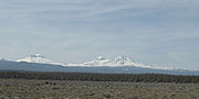
and entering the Cascade Mountains. It intersects Oregon Route 126 west of Santiam Pass
Santiam Pass
Santiam Pass is a mountain pass in the Cascade Range in central Oregon in the United States. It is located on the border between Linn and Jefferson counties, about northwest of Sisters, between the prominent volcanic horns of Three Fingered Jack to the north and Mount Washington to the south...
and the two routes overlap through Sisters
Sisters, Oregon
Sisters is a city in Deschutes County, Oregon, United States. It is part of the Bend, Oregon Metropolitan Statistical Area. The population was 959 at the 2000 census, but more than doubled to 2038 as of the 2010 census.- History :...
. U.S. 20 then continues eastward and southward to Bend
Bend, Oregon
Bend is a city in and the county seat of Deschutes County, Oregon, United States, and the principal city of the Bend, Oregon Metropolitan Statistical Area. Bend is Central Oregon's largest city, and, despite its modest size, is the de facto metropolis of the region, owing to the low population...
, where it overlaps U.S. 97 for about 5 miles (8 km) before turning east through Brothers
Brothers, Oregon
Brothers is an unincorporated community in Deschutes County, Oregon, United States on U.S. Route 20. It is part of the Bend, Oregon Metropolitan Statistical Area. It lies at an elevation of above sea level.-History:...
and Riley
Riley, Oregon
Riley, Oregon is an unincorporated community in Harney County, Oregon, United States. The center of the community is at the crossroads of U.S. Highway 395 and U.S. Highway 20, milepost 104. Riley is about west of Burns, the seat of Harney County. The elevation of Riley is .Riley is farming and...
. At Riley, U.S. 20 overlaps U.S. 395 through Hines
Hines, Oregon
Hines is a city in Harney County, Oregon, United States. The population was 1,563 at the 2010 census.-History:A community named Herrick was formed just southwest of Burns when railroad promoter and sawmill operator Fred Herrick founded a lumber company there...
and Burns
Burns, Oregon
Burns is a city in and the county seat of Harney County, Oregon, United States. As of the 2010 census the population was 2,806.-History:Burns was established in the early 1880s and incorporated upon Harney county's creation in 1889...
to about 2 miles (3.2 km) northeast of Burns. From Burns, U.S. 20 continues east through Juntura
Juntura, Oregon
Juntura is an unincorporated community in Malheur County, Oregon, United States on U.S. Route 20. The word juntura is Spanish for "juncture", and the community was named for its proximity to the confluence of the Malheur River with its north fork. The name was probably selected by local settler B. L...
and Vale
Vale, Oregon
Vale is a city in Malheur County, Oregon, United States, about west of the Idaho border. It is at the intersection of U.S. Routes 20 and 26, on the Malheur River.Vale was selected as Malheur's county seat in 1955, 68 years after the county was founded...
. In Vale, U.S. 20 overlaps U.S. 26
U.S. Route 26 in Oregon
In the U.S. state of Oregon, U.S. Route 26 is a major cross-state state highway, connecting U.S. Route 101 on the Oregon Coast near Seaside with the Idaho state line east of Nyssa. Local highway names include the Sunset Highway No. 47, Mount Hood Highway No. 26, and John Day Highway No...
, and the two highways continue east to Cairo Junction, south of Ontario
Ontario, Oregon
Ontario is the largest city in Malheur County, Oregon, United States. It lies along the Snake River at the Idaho border. The population was 10,985 at the 2000 census, with an estimated population of 11,245 in 2006...
, and turn south, where they then also run concurrently with Oregon Route 201 to Nyssa
Nyssa, Oregon
Nyssa is a city in Malheur County, Oregon, United States. The population was 3,163 at the 2000 census. The city is located along the Snake River on the Idaho border, in the region of far eastern Oregon known as the "Treasure Valley"...
. Eastward from Nyssa, U.S. 20 and U.S. 26 continue to the Idaho
Idaho
Idaho is a state in the Rocky Mountain area of the United States. The state's largest city and capital is Boise. Residents are called "Idahoans". Idaho was admitted to the Union on July 3, 1890, as the 43rd state....
border.
Bannered routes
U.S. Route 20 has 2 business routes in Oregon: one in ToledoToledo, Oregon
Toledo is a city located on the Yaquina River and along U.S. Route 20 in Lincoln County, Oregon, United States. As of the 2000 census, the city had a total population of 3,472...
, and one in Bend
Bend, Oregon
Bend is a city in and the county seat of Deschutes County, Oregon, United States, and the principal city of the Bend, Oregon Metropolitan Statistical Area. Bend is Central Oregon's largest city, and, despite its modest size, is the de facto metropolis of the region, owing to the low population...
.
Route straightening
Construction on a portion of U.S. 20 between Newport and Corvallis, specifically, near ToledoToledo, Oregon
Toledo is a city located on the Yaquina River and along U.S. Route 20 in Lincoln County, Oregon, United States. As of the 2000 census, the city had a total population of 3,472...
to Eddyville
Eddyville, Oregon
Eddyville is an unincorporated community in Lincoln County, Oregon, United States. Eddyville's estimated population as of 2007 was 962 residents....
, is being done to straighten and remove nearly three miles from the route, and make it easier for larger vehicles to travel. Construction began in 2005, but was halted in 2007 because of excessive unexpected landslides. The project recommenced in May 2008 with a better plan for stabilizing these landslide locations. The final construction was expected to be completed in 2011, but continuing earth movement at a bridge site has delayed the project again. ODOT
Oregon Department of Transportation
The Oregon Department of Transportation is a department of the state government of the U.S. state of Oregon responsible for systems of transportation. It was first established in 1969. It had been preceded by the Oregon State Highway Department which, along with the Oregon State Highway...
and the contractor are now in a dispute over liability and money, and the completion date has been postponed until 2012 (small possibility) or 2013 (more likely).
Oregon highway designations
The Oregon section of U.S. 20 consists of the following highways (see Oregon highways and routes), from west to east:- The Corvallis-Newport Highway No. 33;
- Part of the Corvallis-Lebanon Highway No. 210;
- The Albany-Corvallis Highway No. 31;
- The Santiam Highway No. 16;
- Part of the McKenzie Highway No. 15;
- The McKenzie-Bend Highway No. 17;
- Part of The Dalles-California Highway No. 4; and
- The Central Oregon Highway No. 7.
External links
- U.S. 20: Route crosses the Cascades and heads east - The Oregonian