
Lover's Leap
Encyclopedia

Legend
A legend is a narrative of human actions that are perceived both by teller and listeners to take place within human history and to possess certain qualities that give the tale verisimilitude...
s of romantic tragedy are often associated with a Lovers' Leap.
List of locations
In the United States- Bluff Park, HooverHoover, AlabamaHoover is a city in Jefferson and Shelby Counties in north central Alabama, in the United States. The largest suburb of Birmingham, the population of the city was 62,742 as of the 2000 census and 81,619 in the 2010 census. Hoover is part of the Birmingham-Hoover, AL MSA and is also included in the...
, AlabamaAlabamaAlabama is a state located in the southeastern region of the United States. It is bordered by Tennessee to the north, Georgia to the east, Florida and the Gulf of Mexico to the south, and Mississippi to the west. Alabama ranks 30th in total land area and ranks second in the size of its inland... - Lover's Leap, Tombigbee River Mile 96, Jackson, AlabamaJackson, AlabamaJackson is a city in Clarke County, Alabama, United States. The population was 5,228 at the 2010 census. It is one of three wet settlements in an otherwise-dry county.-Geography:Jackson is located at coordinates . According to the U.S...
- Noccalula Falls, Gadsden, AlabamaGadsden, AlabamaThe city of Gadsden is the county seat of Etowah County in the U.S. state of Alabama, and it is located about 65 miles northeast of Birmingham, Alabama. It is the primary city of the Gadsden Metropolitan Statistical Area, which has a population of 103,459. Gadsden is closely associated with the...
- Lovers Leap, Desoto CavernsDeSoto CavernsDeSoto Caverns are a series of geologic caves and a tourist attraction located in Childersburg, Talladega County, Alabama. Located in the foothills of the Appalachian Mountains, it is touted as "Alabama's Big Cave"...
, Childersburg, AlabamaChildersburg, AlabamaChildersburg is a city in Talladega county in the U.S. state of Alabama. At the 2000 census the population was 4,927. It claims a history dating back before 1540, when it was noted as a village of the Coosa Nation visited by the Spanish explorer Hernando de Soto... - Lover's Leap, GreenwoodGreenwood, ArkansasGreenwood is a city in and one of the two county seats of Sebastian County, Arkansas, United States, perhaps best known locally for its Arkansas high school football...
, ArkansasArkansasArkansas is a state located in the southern region of the United States. Its name is an Algonquian name of the Quapaw Indians. Arkansas shares borders with six states , and its eastern border is largely defined by the Mississippi River... - Lover's LeapLover's Leap (Tahoe, CA)Lover's Leap is a vertical granite cliff band which runs for about 2000 feet with heights between 250–600 feet located in the Eldorado National Forest . This cliffs face towards the northwest and lie just south of Route 50, between Tahoe to Sacramento. The closest major urban center is the Tahoe...
, Lake TahoeLake TahoeLake Tahoe is a large freshwater lake in the Sierra Nevada of the United States. At a surface elevation of , it is located along the border between California and Nevada, west of Carson City. Lake Tahoe is the largest alpine lake in North America. Its depth is , making it the USA's second-deepest...
, CaliforniaCaliforniaCalifornia is a state located on the West Coast of the United States. It is by far the most populous U.S. state, and the third-largest by land area... - Quincy, CaliforniaQuincy, CaliforniaQuincy is a census-designated place and the county seat of Plumas County, California. The population was 1,728 at the 2010 census, down from 1,879 at the 2000 census. Quincy is named after the city of Quincy, Illinois...
, off Buck's Lake Road - Lovers Leap, Knights Ferry, CaliforniaKnights Ferry, CaliforniaKnights Ferry is a town in Stanislaus County, California, United States. Nestled in the foothills of the Sierra Nevada, it is about east of Modesto on the Stanislaus River. The Willms Ranch, a California Landmark near the town, was one of many filming locations for the television series Bonanza...
, alongside California Highway 120 - Vail, ColoradoColoradoColorado is a U.S. state that encompasses much of the Rocky Mountains as well as the northeastern portion of the Colorado Plateau and the western edge of the Great Plains...
; name of a run on Blue Sky Basin - Lover's Leap Bridge and State Park, New Milford, ConnecticutNew Milford, ConnecticutNew Milford is a town in southern Litchfield County, Connecticut, United States north of Danbury, on the Housatonic River. It is the largest town in the state in terms of land area at nearly . The population was 28,671 according to the Census Bureau's 2006 estimates...
- Lovers Leap, Sautee-Nacoochee, Georgia
- Starved Rock State ParkStarved Rock State ParkStarved Rock State Park is a state park in Illinois, characterized by the many canyons within its 2360 acres. Located just southwest of the village of North Utica, in Deer Park Township, LaSalle County, Illinois, along the south bank of the Illinois River, the park hosts over two million visitors...
, IllinoisIllinoisIllinois is the fifth-most populous state of the United States of America, and is often noted for being a microcosm of the entire country. With Chicago in the northeast, small industrial cities and great agricultural productivity in central and northern Illinois, and natural resources like coal,... - Lover's Leap, Slade, KentuckySlade, KentuckySlade is an unincorporated rural community in Powell County, Kentucky, United States.A nearby attraction is Natural Bridge State Park.-References:# -Geography:Slade is located at ....
, Natural Bridge State ParkNatural Bridge State Park (Kentucky)Natural Bridge State Resort Park is a Kentucky state park located in Powell and Wolfe Counties along the Middle Fork of the Red River, adjacent to the Red River Gorge Geologic Area and surrounded by the Daniel Boone National Forest. Its namesake natural bridge is the centerpiece of the park. The... - Lover's Leap Park, BangorBangor, MaineBangor is a city in and the county seat of Penobscot County, Maine, United States, and the major commercial and cultural center for eastern and northern Maine...
, MaineMaineMaine is a state in the New England region of the northeastern United States, bordered by the Atlantic Ocean to the east and south, New Hampshire to the west, and the Canadian provinces of Quebec to the northwest and New Brunswick to the northeast. Maine is both the northernmost and easternmost... - Cumberland NarrowsCumberland NarrowsThe Cumberland Narrows is a water gap in western Maryland in the United States, just west of Cumberland, Maryland. Wills Creek cuts through the central ridge of the Wills Mountain Anticline at a low elevation here between Wills Mountain to the north and Haystack Mountain to the south...
, MarylandMarylandMaryland is a U.S. state located in the Mid Atlantic region of the United States, bordering Virginia, West Virginia, and the District of Columbia to its south and west; Pennsylvania to its north; and Delaware to its east... - Purgatory Chasm State ReservationPurgatory Chasm State ReservationPurgatory Chasm State Reservation is a state park in Sutton, Massachusetts. The park, managed by the Massachusetts Department of Conservation and Recreation, is notable for its long, deep chasm of granite bedrock featuring abrupt precipices and boulder caves in which ice lingers into the early...
, MassachusettsMassachusettsThe Commonwealth of Massachusetts is a state in the New England region of the northeastern United States of America. It is bordered by Rhode Island and Connecticut to the south, New York to the west, and Vermont and New Hampshire to the north; at its east lies the Atlantic Ocean. As of the 2010... - Lovers Leap, Hannibal, MissouriHannibal, MissouriHannibal is a city in Marion and Ralls counties in the U.S. state of Missouri. Hannibal is located at the intersection of Interstate 72 and U.S. Routes 24, 36 and 61, approximately northwest of St. Louis. According to the 2010 U.S. Census the population was 17,606...
- Philmont Scout RanchPhilmont Scout RanchPhilmont Scout Ranch is a large, rugged, mountainous ranch located near the town of Cimarron, New Mexico, covering approximately of wilderness in the Sangre de Cristo Mountains of the Rocky Mountains of northern New Mexico...
, outside Cimarron, New MexicoCimarron, New Mexico-Demographics:As of the census of 2000, there were 917 people, 382 households, and 255 families residing in the village. The population density was 479.5 people per square mile . There were 449 housing units at an average density of 234.8 per square mile... - Eagles Mere, PennsylvaniaEagles Mere, PennsylvaniaEagles Mere is a borough in Sullivan County, Pennsylvania, USA. The population was 120 at the 2010 census.-Geography:According to the United States Census Bureau, the borough has a total area of , of which, of it is land and of it is water....
- Rock CityRock CityRock City is a roadside attraction near Chattanooga, Tennessee, on Lookout Mountain in Lookout Mountain, Georgia, located near Ruby Falls. It is well-known for the many barn advertisements throughout the Southeast and Midwest United States that have the slogan "See Rock City" painted on barn roofs...
, a roadside attraction on Lookout MountainLookout Mountainthumb|right|See seven statesLookout Mountain is located at the northwest corner of the U.S. state of Georgia, the northeast corner of Alabama, and along the southern border of Tennessee at Chattanooga. Lookout Mountain, along with Sand Mountain to the northwest, makes up a large portion of the...
near Chattanooga, TennesseeChattanooga, TennesseeChattanooga is the fourth-largest city in the US state of Tennessee , with a population of 169,887. It is the seat of Hamilton County... - Lover's Leap, in Cameron Park, Waco, TexasWaco, TexasWaco is a city in and the county seat of McLennan County, Texas. Situated along the Brazos River and on the I-35 corridor, halfway between Dallas and Austin, it is the economic, cultural, and academic center of the 'Heart of Texas' region....
- Natural Tunnel, Duffield, VirginiaDuffield, VirginiaDuffield is a town in Scott County, Virginia, United States. The population was 91 at the 2010 census. It is part of the Kingsport–Bristol –Bristol Metropolitan Statistical Area, which is a component of the Johnson City–Kingsport–Bristol, TN-VA Combined Statistical Area – commonly known as...
- Lover's Leap in Patrick County, VirginiaPatrick County, VirginiaPatrick County is a county located in the Commonwealth of Virginia. As of 2010, the population was 18,490. Its county seat is Stuart. It is located within both the rolling hills and valleys of the Piedmont Region of Virginia and mountainous Southwest Virginia....
, about 10 miles (16.1 km) west of StuartStuart, VirginiaStuart is a town in Patrick County, Virginia, United States, and its county seat. The population was 961 at the 2000 census. Due to recent boundary expansion, the town of Stuart has an estimated population of nearly 1,700 residents. The town of Stuart was named after Confederate Gen. J.E.B...
on U.S. Highway 58 - Lover's Leap, Turn Point, Stuart IslandStuart Island (Washington)Stuart Island is one of the San Juan Islands in Washington state, USA, north of San Juan Island and west of Waldron Island. The island is home to two communities of full and part-time residents, a state park, a one-room schoolhouse, and two airstrips .The 2000 census...
, Washington
Elsewhere
- Fonte dos Amores, Poços de CaldasPoços de CaldasPoços de Caldas is a city and municipality in south-western Minas Gerais state, Brazil, in the microregion of the same name. Its estimated population in 2009 was 151,449 inhabitants...
, Minas GeraisMinas GeraisMinas Gerais is one of the 26 states of Brazil, of which it is the second most populous, the third richest, and the fourth largest in area. Minas Gerais is the Brazilian state with the largest number of Presidents of Brazil, the current one, Dilma Rousseff, being one of them. The capital is the...
, BrazilBrazilBrazil , officially the Federative Republic of Brazil , is the largest country in South America. It is the world's fifth largest country, both by geographical area and by population with over 192 million people... - Elora Gorge, Elora, OntarioElora, OntarioElora is a community in the township of Centre Wellington, Wellington County, Ontario, Canada. It is well known for its 19th-century limestone architecture, its artistic community and the geographically significant Elora Gorge.-History:...
, CanadaCanadaCanada is a North American country consisting of ten provinces and three territories. Located in the northern part of the continent, it extends from the Atlantic Ocean in the east to the Pacific Ocean in the west, and northward into the Arctic Ocean... - Lover's Leap Rock, Dargle Valley, BrayBrayBray is a town in north County Wicklow, Ireland. It is a busy urban centre and seaside resort, with a population of 31,901 making it the fourth largest in Ireland as of the 2006 census...
, County WicklowCounty WicklowCounty Wicklow is a county in Ireland. It is part of the Mid-East Region and is also located in the province of Leinster. It is named after the town of Wicklow, which derives from the Old Norse name Víkingalág or Wykynlo. Wicklow County Council is the local authority for the county...
, IrelandIrelandIreland is an island to the northwest of continental Europe. It is the third-largest island in Europe and the twentieth-largest island on Earth... - Lover's Leap, Saint ElizabethSaint ElizabethSaint Elizabeth may refer to:* Saint Elizabeth , the mother of John the Baptist* Saint Elisabeth of Hungary * Saint Elizabeth of Portugal * Saint Elizabeth of Reute...
, JamaicaJamaicaJamaica is an island nation of the Greater Antilles, in length, up to in width and 10,990 square kilometres in area. It is situated in the Caribbean Sea, about south of Cuba, and west of Hispaniola, the island harbouring the nation-states Haiti and the Dominican Republic... - Lovers' Rock (la Peña de los Enamorados), AntequeraAntequeraAntequera is a city and municipality in the province of Málaga, part of the Spanish autonomous community of Andalusia. It is known as "the heart of Andalusia" because of its central location among Málaga, Granada, Córdoba, and Seville...
, Andalucia, SpainSpainSpain , officially the Kingdom of Spain languages]] under the European Charter for Regional or Minority Languages. In each of these, Spain's official name is as follows:;;;;;;), is a country and member state of the European Union located in southwestern Europe on the Iberian Peninsula... - Lovers LeapSandymount, New ZealandSandymount is the name of a prominent hill on Otago Peninsula, in the southeastern South Island of New Zealand. It is 13 kilometres east of the city centre of Dunedin, close to the northeastern end of Sandfly Bay, and rises to a height of 312 metres...
, Otago PeninsulaOtago PeninsulaThe Otago Peninsula is a long, hilly indented finger of land that forms the easternmost part of Dunedin, New Zealand. Volcanic in origin, it forms one wall of the eroded valley that now forms Otago Harbour. The peninsula lies south-east of Otago Harbour and runs parallel to the mainland for...
, DunedinDunedinDunedin is the second-largest city in the South Island of New Zealand, and the principal city of the Otago Region. It is considered to be one of the four main urban centres of New Zealand for historic, cultural, and geographic reasons. Dunedin was the largest city by territorial land area until...
, New ZealandNew ZealandNew Zealand is an island country in the south-western Pacific Ocean comprising two main landmasses and numerous smaller islands. The country is situated some east of Australia across the Tasman Sea, and roughly south of the Pacific island nations of New Caledonia, Fiji, and Tonga... - Lover's Leap, TrincomaleeTrincomaleeTrincomalee is a port city in Eastern Province, Sri Lanka and lies on the east coast of the island, about 113 miles south of Jaffna. It has a population of approximately 100,000 . The city is built on a peninsula, which divides the inner and outer harbours. Overlooking the Kottiyar Bay,...
, Sri LankaSri LankaSri Lanka, officially the Democratic Socialist Republic of Sri Lanka is a country off the southern coast of the Indian subcontinent. Known until 1972 as Ceylon , Sri Lanka is an island surrounded by the Indian Ocean, the Gulf of Mannar and the Palk Strait, and lies in the vicinity of India and the... - Lover's Leap, Dovedale, Peak DistrictPeak DistrictThe Peak District is an upland area in central and northern England, lying mainly in northern Derbyshire, but also covering parts of Cheshire, Greater Manchester, Staffordshire, and South and West Yorkshire....
, EnglandEnglandEngland is a country that is part of the United Kingdom. It shares land borders with Scotland to the north and Wales to the west; the Irish Sea is to the north west, the Celtic Sea to the south west, with the North Sea to the east and the English Channel to the south separating it from continental...
, United KingdomUnited KingdomThe United Kingdom of Great Britain and Northern IrelandIn the United Kingdom and Dependencies, other languages have been officially recognised as legitimate autochthonous languages under the European Charter for Regional or Minority Languages... - La piedra feliz, ValparaisoValparaísoValparaíso is a city and commune of Chile, center of its third largest conurbation and one of the country's most important seaports and an increasing cultural center in the Southwest Pacific hemisphere. The city is the capital of the Valparaíso Province and the Valparaíso Region...
, ChileChileChile ,officially the Republic of Chile , is a country in South America occupying a long, narrow coastal strip between the Andes mountains to the east and the Pacific Ocean to the west. It borders Peru to the north, Bolivia to the northeast, Argentina to the east, and the Drake Passage in the far...
United States
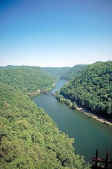
The Lover's Leap at Hawk's NestHawk's Nest, West Virginia
Hawk's Nest, the site of Hawks Nest State Park, is a peak on Gauley Mountain in Ansted, West Virginia, USA. The cliffs at this point rise 585 ft above the New River. Located on the James River and Kanawha Turnpike , many early travelers on this road stopped to see the view of the river below...
in Hawk's Nest State Park in the town of Ansted, West Virginia
Ansted, West Virginia
Ansted is a town in Fayette County in the U.S. state of West Virginia. It is situated on high bluffs along U.S. Highway 60 on a portion of the Midland Trail a National Scenic Byway near Hawk's Nest overlooking the New River far below....
, United States
United States
The United States of America is a federal constitutional republic comprising fifty states and a federal district...
, along the historic Midland Trail
Midland Trail
For the trail's section in West Virginia see: The Midland Trail in West Virginia.The Midland Trail, also called the Roosevelt Midland Trail, was a national auto trail spanning the United States from Washington, D.C...
has a drop of 178 m
1 E2 m
To compare different orders of magnitude this page lists lengths between 100 metres and 1000 metres .Distances shorter than 100 metres-Conversions:100 metres is equal to:* 328 feet...
(585 feet (178.3 m)) from a high bluff
Cliff
In geography and geology, a cliff is a significant vertical, or near vertical, rock exposure. Cliffs are formed as erosion landforms due to the processes of erosion and weathering that produce them. Cliffs are common on coasts, in mountainous areas, escarpments and along rivers. Cliffs are usually...
overlooking the New River Gorge
New River (West Virginia)
The New River, part of the Ohio River watershed, is a tributary of the Kanawha River about 320 mi long. The river flows through the U.S. states of North Carolina, Virginia, and West Virginia...
. The promontory was named "Lover's Leap" by settlers, and has acquired a legend
Legend
A legend is a narrative of human actions that are perceived both by teller and listeners to take place within human history and to possess certain qualities that give the tale verisimilitude...
involving two young Native Americans
Native Americans in the United States
Native Americans in the United States are the indigenous peoples in North America within the boundaries of the present-day continental United States, parts of Alaska, and the island state of Hawaii. They are composed of numerous, distinct tribes, states, and ethnic groups, many of which survive as...
from different tribe
Tribe
A tribe, viewed historically or developmentally, consists of a social group existing before the development of, or outside of, states.Many anthropologists use the term tribal society to refer to societies organized largely on the basis of kinship, especially corporate descent groups .Some theorists...
s.
Blowing Rock Mountain, outside Blowing Rock, North Carolina
Blowing Rock, North Carolina
Blowing Rock is a town in North Carolina, USA, situated in both Caldwell and Watauga counties. The population was 1,418 at the 2000 census. However, during the summer the town's population increases to about 10,000.]]\\...
, has a similar legend of a young lover leaping from the cliff and instead of plunging to his death, is saved. In this version the lover is saved by the blowing wind which sends him back into the arms of his sweetheart.
Wills Mountain
Wills Mountain
Wills Mountain is a quartzite-capped ridge in the Ridge and Valley physiographic province of the Appalachian Mountains in Pennsylvania and Maryland, USA, extending from near Bedford, Pennsylvania to near Cumberland, Maryland...
has a Lover's Leap overlooking Cumberland Narrows
Cumberland Narrows
The Cumberland Narrows is a water gap in western Maryland in the United States, just west of Cumberland, Maryland. Wills Creek cuts through the central ridge of the Wills Mountain Anticline at a low elevation here between Wills Mountain to the north and Haystack Mountain to the south...
at Cumberland, Maryland
Cumberland, Maryland
Cumberland is a city in the far western, Appalachian portion of Maryland, United States. It is the county seat of Allegany County, and the primary city of the Cumberland, MD-WV Metropolitan Statistical Area. At the 2010 census, the city had a population of 20,859, and the metropolitan area had a...
, USA. It is 1652 feet (503.5 m) above sea level and made up of oddly squared projections of rock from its top all the way down to the National Road
National Road
The National Road or Cumberland Road was the first major improved highway in the United States to be built by the federal government. Construction began heading west in 1811 at Cumberland, Maryland, on the Potomac River. It crossed the Allegheny Mountains and southwestern Pennsylvania, reaching...
(U.S. Rte. 40) below. The city of Cumberland and the surrounding states of Pennsylvania
Pennsylvania
The Commonwealth of Pennsylvania is a U.S. state that is located in the Northeastern and Mid-Atlantic regions of the United States. The state borders Delaware and Maryland to the south, West Virginia to the southwest, Ohio to the west, New York and Ontario, Canada, to the north, and New Jersey to...
and West Virginia
West Virginia
West Virginia is a state in the Appalachian and Southeastern regions of the United States, bordered by Virginia to the southeast, Kentucky to the southwest, Ohio to the northwest, Pennsylvania to the northeast and Maryland to the east...
may be seen from this point.
Mark Twain
Mark Twain
Samuel Langhorne Clemens , better known by his pen name Mark Twain, was an American author and humorist...
in Life on the Mississippi
Life on the Mississippi
Life on the Mississippi is a memoir by Mark Twain, of his days as a steamboat pilot on the Mississippi River before the American Civil War, and also a travel book, recounting his trip along the Mississippi many years after the War....
writes: "There are fifty Lover's Leaps along the Mississippi from whose summit disappointed Indian girls have jumped." Princess Winona
Princess Winona
Princess Winona is the central Native American character in a "Lover's Leap" romantic legend set at Maiden Rock on the Wisconsin side of Lake Pepin in the United States. Princess Winona leaps to her death from Maiden Rock rather than marry a suitor she does not love.-The legend:There are several...
is one such legend, in which Princess Winona leaps to her death rather than marry a suitor she does not love. Maiden Rock, Wisconsin
Maiden Rock, Wisconsin
Maiden Rock is a village in Pierce County, Wisconsin, United States. The population was 119 at the 2010 census. The village is located within the Town of Maiden Rock. The town is named for a cliff just south of the village...
, USA, is one site for the Princess Winona legend, though other locations include Winona Falls in Pennsylvania, Camden County, Missouri
Camden County, Missouri
Camden County is a county located in the U.S. state of Missouri. As of 2000, the population was 37,051. Its county seat is Camdenton. The county was organized in 1841 as Kinderhook County and renamed in 1843, for Charles Pratt, 1st Earl Camden, Chancellor of England, and leader of the Whig...
and Cameron Park in Waco, Texas
Waco, Texas
Waco is a city in and the county seat of McLennan County, Texas. Situated along the Brazos River and on the I-35 corridor, halfway between Dallas and Austin, it is the economic, cultural, and academic center of the 'Heart of Texas' region....
.
Other
DovedaleDovedale
Dovedale is a popular dale in the Peak District, England. It is owned by the National Trust, and annually attracts a million visitors. The valley is cut by the River Dove and runs for just over between Milldale in the north and a wooded ravine near Thorpe Cloud and Bunster Hill in the south...
in the Peak District
Peak District
The Peak District is an upland area in central and northern England, lying mainly in northern Derbyshire, but also covering parts of Cheshire, Greater Manchester, Staffordshire, and South and West Yorkshire....
in the United Kingdom
United Kingdom
The United Kingdom of Great Britain and Northern IrelandIn the United Kingdom and Dependencies, other languages have been officially recognised as legitimate autochthonous languages under the European Charter for Regional or Minority Languages...
has a limestone promontory named Lover's Leap reached by a set of steps built by Italian prisoners of war captured in World War II
World War II
World War II, or the Second World War , was a global conflict lasting from 1939 to 1945, involving most of the world's nations—including all of the great powers—eventually forming two opposing military alliances: the Allies and the Axis...
. The local legend is that a young woman believed her lover had been killed in the Napoleonic wars
Napoleonic Wars
The Napoleonic Wars were a series of wars declared against Napoleon's French Empire by opposing coalitions that ran from 1803 to 1815. As a continuation of the wars sparked by the French Revolution of 1789, they revolutionised European armies and played out on an unprecedented scale, mainly due to...
, so she threw herself off the top of the promontory. Later, her family found out that her boyfriend was alive and well.
Jamaica, on the south coast of St. Elizabeth
Saint Elizabeth Parish, Jamaica
St. Elizabeth, one of Jamaica's largest parishes, is located in the southwest of the island, in the county of Cornwall. Its capital, Black River, is located at the mouth of the Black River, the longest on the island.-History:...
, has a Lover's Leap 1700 feet (518.2 m) above the Caribbean Sea
Caribbean Sea
The Caribbean Sea is a sea of the Atlantic Ocean located in the tropics of the Western hemisphere. It is bounded by Mexico and Central America to the west and southwest, to the north by the Greater Antilles, and to the east by the Lesser Antilles....
. Lovers' leap is named after two slave lovers from the 18th century, Mizzy and Tunkey. According to legend, their master, Chardley, liked Mizzy; so, in a bid to have her for himself, he arranged for her lover, Tunkey, to be sold to another estate. Mizzy and Tunkey fled to avoid being separated but were eventually chased to the edge of a large steep cliff. Rather than face being caught and separated, the lovers embraced and jumped over the cliff. The story was used as the basis for a romantic novel.