

London Plan
Encyclopedia
Mayor of London
The Mayor of London is an elected politician who, along with the London Assembly of 25 members, is accountable for the strategic government of Greater London. Conservative Boris Johnson has held the position since 4 May 2008...
, England
England
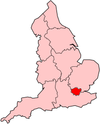
England is a country that is part of the United Kingdom. It shares land borders with Scotland to the north and Wales to the west; the Irish Sea is to the north west, the Celtic Sea to the south west, with the North Sea to the east and the English Channel to the south separating it from continental...
in the United Kingdom
United Kingdom
The United Kingdom of Great Britain and Northern IrelandIn the United Kingdom and Dependencies, other languages have been officially recognised as legitimate autochthonous languages under the European Charter for Regional or Minority Languages...
and published by the Greater London Authority
Greater London Authority
The Greater London Authority is the top-tier administrative body for Greater London, England. It consists of a directly elected executive Mayor of London, currently Boris Johnson, and an elected 25-member London Assembly with scrutiny powers...
. The plan was first published in final form on 10 February 2004 and has since been amended. The current version was published in February 2008. The latest proposed amendments to the London Plan were published in April 2009 with consultation starting in October 2009 and the replacement plan expected to be published in 2011.
Mandate
The plan replaced the previous strategic planning guidance for London issued by the Secretary of State and known as RPGRegional Planning Guidance
Regional planning guidance is the predecessor of regional spatial strategies. The RPGs include:*Regional Planning Guidance 1: North East *Regional Planning Guidance 6: East Anglia to 2016 *Regional Planning Guidance 8: East Midlands...
3. It is a requirement of the Greater London Authority Act 1999
Greater London Authority Act 1999
The Greater London Authority Act 1999 is the Act of Parliament that established the Greater London Authority, the London Assembly and the Mayor of London....
that the document is produced and that it deals only with matters that are of strategic importance to Greater London. The Act also requires that the London Plan includes in its scope:
- the health of Londoners,
- equality of opportunityEqual opportunityEqual opportunity, or equality of opportunity, is a controversial political concept; and an important informal decision-making standard without a precise definition involving fair choices within the public sphere...
, - contribution to sustainable developmentSustainable developmentSustainable development is a pattern of resource use, that aims to meet human needs while preserving the environment so that these needs can be met not only in the present, but also for generations to come...
in the United Kingdom.
Objectives
The plan is a spatial development strategy for the Greater LondonGreater London
Greater London is the top-level administrative division of England covering London. It was created in 1965 and spans the City of London, including Middle Temple and Inner Temple, and the 32 London boroughs. This territory is coterminate with the London Government Office Region and the London...
area and has six objectives:
- To accommodate London’s growth within its boundaries without encroaching on open spaces
- To make London a better city for people to live in
- To make London a more prosperous city with strong and diverse economic growth
- To promote social inclusion and tackle deprivation and discrimination
- To improve London’s accessibility
- To make London a more attractive, well-designed and green city
Policies
| Chapter | Title | Policy summary |
|---|---|---|
| 1 | Positioning London | Analysis of forces underpinning London's past and future place in the world |
| 2 | The broad development strategy | Strategic sustainable development policy |
| 3 | Thematic policies | Population growth, economic growth, transport, development |
| 4 | Crosscutting policies | Environment, quality of life, heritage, Blue Ribbon Network Blue Ribbon Network The Blue Ribbon Network is a policy element of the London Plan relating to the naviagable waterways of London, England.Aside from the River Thames, the major components of the network are:#Grand Union Canal#Regent's Canal#River Lee Navigation#River Brent... |
| 5 | The sub-regions | Development of Sub-Regional Development Frameworks |
| 6 | Delivering the vision | Delivery, performance indicators, monitoring |
Opportunity areas
The plan identifies dozens of areas of opportunity, which are where the bulk of efforts will be concentrated, with an aim at reducing social deprivation and creating sustainable development. The opportunity areas will be able to accommodate around 5,000 jobs each or about 2,500 homes, or a mixture of the two. The opportunity areas will mostly be town centres as opposed to suburban developments in the boroughs, although those are mentioned as important in terms of job growth and quality of life.Sub regions
For the purposes of the plan, London is divided into five sub regions. The current regions were established in February 2008 as part of the Further Alterations to the London Plan. The sub regions radiate from the centre to combine inner and outer London boroughs. These sub-regions, each with its own Sub Regional Implementation Framework, are:| Sub region | London boroughs | Population | Jobs | Map |
|---|---|---|---|---|
| North East North East (London sub region) The North East is a sub-region of the London Plan corresponding to the London Boroughs of Tower Hamlets, Newham, Waltham Forest, Redbridge, Havering, Barking and Dagenham, and the City of London. The sub region was established in 2008 and replaced the larger East sub region that had been... |
Barking & Dagenham, City of London, Havering, Newham, Redbridge, Tower Hamlets, Waltham Forest | 1.4 million | 900,000 | NE |
| North North (London sub region) The North is a sub-region of the London Plan corresponding to the London Boroughs of Barnet, Camden, Enfield, Hackney, Haringey, Islington and Westminster. The sub region was established in 2004, consisting of Barnet, Enfield, Haringey and Waltham Forest... |
Barnet, Camden, Enfield, Hackney, Haringey, Islington, Westminster | 1.7 million | 1.5 million | N |
| South East South East (London sub region) The South East is a sub-region of the London Plan corresponding to the London Boroughs of Bexley, Bromley, Greenwich, Lewisham and Southwark. The sub region was established in 2008. The south east has a population of 1,300,000 and is the location of 500,000 jobs... |
Bexley, Bromley, Greenwich, Lewisham, Southwark | 1.3 million | 500,000 | SE |
| South West South West (London sub region) The South West is a sub-region of the London Plan corresponding to the London Boroughs of London Borough of , Kingston upon Thames, Lambeth, Merton, Richmond upon Thames, Sutton and Wandsworth. The sub region was established in 2008. The south west has a population of 1,600,000 and is the location... |
Croydon, Kingston, Lambeth, Merton, Richmond, Sutton, Wandsworth | 1.6 million | 730,000 | SW |
| West West (London sub region) The West is a sub-region of the London Plan corresponding to the London Boroughs of Brent, Ealing, Hammersmith and Fulham, Harrow, Hillingdon and Hounslow. The sub region was established in 2004 and was adjusted in 2008 to include Kensington and Chelsea. The west has a population of 1.6 million and... |
Brent, Ealing, Hammersmith & Fulham, Harrow, Hillingdon, Hounslow, Kensington & Chelsea | 1.6 million | 900,000 | W |
From 2004 to 2008 the sub regions were initially the same as the Learning and Skills Council
Learning and Skills Council
The Learning and Skills Council was a non-departmental public body jointly sponsored by the Department for Business, Innovation and Skills and the Department for Children, Schools and Families in England...
areas set up in 1999: Within this scheme there was a separate Central sub region. The London part of the Thames Gateway
Thames Gateway
The Thames Gateway is an area of land stretching east from inner east London on both sides of the River Thames and the Thames Estuary. The area, which includes much brownfield land, has been designated a national priority for urban regeneration, taking advantage of the development opportunities...
zone was entirely contained within the East London sub region. The 2004 to 2008 sub regions, which each had Sub-Regional Development Frameworks, were:
| Sub region | London boroughs | Population (2001) | 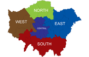 |
|---|---|---|
| Central | Camden, Kensington & Chelsea, Islington, Lambeth, Southwark, Wandsworth, Westminster. Although it is not part of the sub region Hammersmith and Fulham is often considered part of central London Central London Central London is the innermost part of London, England. There is no official or commonly accepted definition of its area, but its characteristics are understood to include a high density built environment, high land values, an elevated daytime population and a concentration of regionally,... . |
1,525,000 |
| East | Barking & Dagenham, Bexley, City of London, Greenwich, Lewisham, Hackney, Havering, Newham, Redbridge, Tower Hamlets | 1,991,000 |
| North | Barnet, Enfield, Haringey, Waltham Forest | 1,042,000 |
| South | Bromley, Croydon, Kingston, Merton, Richmond, Sutton | 1,329,000 |
| West | Brent, Ealing, Hammersmith & Fulham, Harrow, Hillingdon, Hounslow | 1,421,000 |
Separately defined is a Central Activities Zone which includes areas with a very high concentration of metropolitan activities.
Activity centres
All activity centreActivity centre
Activity centre is a term used in urban planning and design for a mixed-use urban area where there is a concentration of commercial and other land uses...
s are categorised into two international centres, the West End
West End of London
The West End of London is an area of central London, containing many of the city's major tourist attractions, shops, businesses, government buildings, and entertainment . Use of the term began in the early 19th century to describe fashionable areas to the west of Charing Cross...
and Knightsbridge
Knightsbridge
Knightsbridge is a road which gives its name to an exclusive district lying to the west of central London. The road runs along the south side of Hyde Park, west from Hyde Park Corner, spanning the City of Westminster and the Royal Borough of Kensington and Chelsea...
; eleven metropolitan centres such as Bromley
Bromley
Bromley is a large suburban town in south east London, England and the administrative headquarters of the London Borough of Bromley. It was historically a market town, and prior to 1963 was in the county of Kent and formed the administrative centre of the Municipal Borough of Bromley...
, Croydon
Croydon
Croydon is a town in South London, England, located within the London Borough of Croydon to which it gives its name. It is situated south of Charing Cross...
, Sutton
Sutton, London
Sutton is a large suburban town in southwest London, England, and the administrative headquarters of the London Borough of Sutton. It is located south-southwest of Charing Cross and is one of the major metropolitan centres identified in the London Plan. The town was connected to central London by...
and Romford
Romford
Romford is a large suburban town in north east London, England and the administrative headquarters of the London Borough of Havering. It is located northeast of Charing Cross and is one of the major metropolitan centres identified in the London Plan...
; 35 major centres such as Brixton
Brixton
Brixton is a district in the London Borough of Lambeth in south London, England. It is south south-east of Charing Cross. The area is identified in the London Plan as one of 35 major centres in Greater London....
, East Ham
East Ham
East Ham is a suburban district of London, England, and part of the London Borough of Newham. It is a built-up district located 8 miles east-northeast of Charing Cross...
, Bexleyheath
Bexleyheath
Bexleyheath is a main suburban district of Southeast London, England, in the London Borough of Bexley with a small percentage of the district itself being in the London Borough of Greenwich. Bexleyheath is located on the border of Inner London and Outer London. It is east south-east of Charing Cross...
and Woolwich
Woolwich
Woolwich is a district in south London, England, located in the London Borough of Greenwich. The area is identified in the London Plan as one of 35 major centres in Greater London.Woolwich formed part of Kent until 1889 when the County of London was created...
; and 156 district centres such as Hornchurch
Hornchurch
Hornchurch is a large suburban town in England, and part of the London Borough of Havering. Hornchurch is in North-East London .It is located east-northeast of Charing Cross and is one of the locally important district centres identified in the London Plan. It comprises a number of shopping...
, Penge
Penge
Penge is a suburb of London in the London Borough of Bromley. It is located south east of Charing Cross.-History:Penge was once a small town, which was recorded under the name Penceat in a Saxon deed dating from 957...
, Stoke Newington
Stoke Newington
Stoke Newington is a district in the London Borough of Hackney. It is north-east of Charing Cross.-Boundaries:In modern terms, Stoke Newington can be roughly defined by the N16 postcode area . Its southern boundary with Dalston is quite ill-defined too...
and Welling
Welling
Welling is a district in the London Borough of Bexley, South East London. It is a suburban development situated between Shooter's Hill and Bexleyheath north of the A2 road and 10.5 miles east south-east of Charing Cross.-History:...
. Over 1,200 smaller neighbourhood and local centres are also identified in the plan.
| International centres (2) | West End West End of London The West End of London is an area of central London, containing many of the city's major tourist attractions, shops, businesses, government buildings, and entertainment . Use of the term began in the early 19th century to describe fashionable areas to the west of Charing Cross... , Knightsbridge Knightsbridge Knightsbridge is a road which gives its name to an exclusive district lying to the west of central London. The road runs along the south side of Hyde Park, west from Hyde Park Corner, spanning the City of Westminster and the Royal Borough of Kensington and Chelsea... |
|---|---|
| Metropolitan centres (11) | Bromley Bromley Bromley is a large suburban town in south east London, England and the administrative headquarters of the London Borough of Bromley. It was historically a market town, and prior to 1963 was in the county of Kent and formed the administrative centre of the Municipal Borough of Bromley... , Croydon Croydon Croydon is a town in South London, England, located within the London Borough of Croydon to which it gives its name. It is situated south of Charing Cross... , Ealing Ealing Ealing is a suburban area of west London, England and the administrative centre of the London Borough of Ealing. It is located west of Charing Cross and around from the City of London. It is one of the major metropolitan centres identified in the London Plan. It was historically a rural village... , Harrow Harrow, London Harrow is an area in the London Borough of Harrow, northwest London, United Kingdom. It is a suburban area and is situated 12.2 miles northwest of Charing Cross... , Hounslow Hounslow Hounslow is the principal town in the London Borough of Hounslow. It is a suburban development situated 10.6 miles west south-west of Charing Cross. It forms a post town in the TW postcode area.-Etymology:... , Kingston Kingston upon Thames Kingston upon Thames is the principal settlement of the Royal Borough of Kingston upon Thames in southwest London. It was the ancient market town where Saxon kings were crowned and is now a suburb situated south west of Charing Cross. It is one of the major metropolitan centres identified in the... , Ilford Ilford Ilford is a large cosmopolitan town in East London, England and the administrative headquarters of the London Borough of Redbridge. It is located northeast of Charing Cross and is one of the major metropolitan centres identified in the London Plan. It forms a significant commercial and retail... , Romford Romford Romford is a large suburban town in north east London, England and the administrative headquarters of the London Borough of Havering. It is located northeast of Charing Cross and is one of the major metropolitan centres identified in the London Plan... , Sutton Sutton, London Sutton is a large suburban town in southwest London, England, and the administrative headquarters of the London Borough of Sutton. It is located south-southwest of Charing Cross and is one of the major metropolitan centres identified in the London Plan. The town was connected to central London by... , Uxbridge Uxbridge Uxbridge is a large town located in north west London, England and is the administrative headquarters of the London Borough of Hillingdon. It forms part of the ceremonial county of Greater London. It is located west-northwest of Charing Cross and is one of the major metropolitan centres... , Wood Green Wood Green Wood Green is a district in north London, England, located in the London Borough of Haringey. It is situated north of Charing Cross. The area is identified in the London Plan as one of the metropolitan centres in Greater London.-History:... . |
| Major centres (35) | Angel The Angel, Islington Angel is a district of London, England, and part of the London Borough of Islington. The area is identified in the London Plan as one of 35 major centres in Greater London.-History:... , Barking Barking Barking is a suburban town in the London Borough of Barking and Dagenham, in East London, England. A retail and commercial centre situated in the west of the borough, it lies east of Charing Cross. Barking was in the historic county of Essex until it was absorbed by Greater London. The area is... , Bexleyheath Bexleyheath Bexleyheath is a main suburban district of Southeast London, England, in the London Borough of Bexley with a small percentage of the district itself being in the London Borough of Greenwich. Bexleyheath is located on the border of Inner London and Outer London. It is east south-east of Charing Cross... , Brixton Brixton Brixton is a district in the London Borough of Lambeth in south London, England. It is south south-east of Charing Cross. The area is identified in the London Plan as one of 35 major centres in Greater London.... , Camden Town Camden Town -Economy:In recent years, entertainment-related businesses and a Holiday Inn have moved into the area. A number of retail and food chain outlets have replaced independent shops driven out by high rents and redevelopment. Restaurants have thrived, with the variety of culinary traditions found in... , Canary Wharf Canary Wharf Canary Wharf is a major business district located in London, United Kingdom. It is one of London's two main financial centres, alongside the traditional City of London, and contains many of the UK's tallest buildings, including the second-tallest , One Canada Square... , Catford Catford Catford is a district in south London, England, located in the London Borough of Lewisham. It is situated south-east of Charing Cross. The area is identified in the London Plan as one of 35 major centres in Greater London.-Architecture:... , Chiswick Chiswick Chiswick is a large suburb of west London, England and part of the London Borough of Hounslow. It is located on a meander of the River Thames, west of Charing Cross and is one of 35 major centres identified in the London Plan. It was historically an ancient parish in the county of Middlesex, with... , Clapham Junction, Dalston Dalston Dalston is a district of north-east London, England, located in the London Borough of Hackney. It is situated northeast of Charing Cross. The area is identified in the London Plan as one of 35 major centres in Greater London... , East Ham East Ham East Ham is a suburban district of London, England, and part of the London Borough of Newham. It is a built-up district located 8 miles east-northeast of Charing Cross... , Edgware Edgware Edgware is an area in London, situated north-northwest of Charing Cross. It forms part of both the London Borough of Barnet and the London Borough of Harrow. The area is identified in the London Plan as one of 35 major centres in Greater London.... , Eltham Eltham, London -Parks and open spaces:There is a large variety of open green space in Eltham, in the form of parkland, fields and woodland.*Avery Hill Park is large, open parkland, situated to the east of Eltham. It is most notable for its Winter Garden, a hothouse containing tropical trees and plants from around... , Enfield Town Enfield Town Enfield Town is the historic town centre of Enfield, formerly in the county of Middlesex and now in the London Borough of Enfield. It is north north-east of Charing Cross... , Fulham Fulham Fulham is an area of southwest London in the London Borough of Hammersmith and Fulham, SW6 located south west of Charing Cross. It lies on the left bank of the Thames, between Putney and Chelsea. The area is identified in the London Plan as one of 35 major centres in Greater London... , Hammersmith Hammersmith Hammersmith is an urban centre in the London Borough of Hammersmith and Fulham in west London, England, in the United Kingdom, approximately five miles west of Charing Cross on the north bank of the River Thames... , Holloway Nag's Head Nag's Head, London Nag's Head, Holloway is a locality within the Holloway district in the London Borough of Islington. It was originally named after the Nag's Head public house on the Holloway Road . The pub was once renamed the "Mustang Diner". It changed to "O'Neills" when it was bought by a pub chain of that name... , Kensington High Street Kensington High Street Kensington High Street is the main shopping street in Kensington, west London. The area is identified in the London Plan as one of 35 major centres in Greater London.... , Kilburn, King's Road East, Lewisham Lewisham Lewisham is a district in South London, England, located in the London Borough of Lewisham. It is situated south-east of Charing Cross. The area is identified in the London Plan as one of 35 major centres in Greater London.-History:... , Orpington Orpington Orpington is a suburban town and electoral ward in the London Borough of Bromley. It forms the southeastern edge of London's urban sprawl and is identified in the London Plan as one of 35 major centres in Greater London.-History:... , Peckham Peckham Peckham is a district in south London, England, located in the London Borough of Southwark. It is situated south-east of Charing Cross. The area is identified in the London Plan as one of 35 major centres in Greater London... , Putney Putney Putney is a district in south-west London, England, located in the London Borough of Wandsworth. It is situated south-west of Charing Cross. The area is identified in the London Plan as one of 35 major centres in Greater London.... , Richmond, Queensway Queensway (London) Queensway is a bustling cosmopolitan street in the Bayswater district of west London. It contains many restaurants , pubs, letting agents, and high street stores... /Westbourne Grove Westbourne Grove Westbourne Grove is a retail road running across Notting Hill, in the Royal Borough of Kensington and Chelsea, a section of west London, England. It runs from Kensington Park Road in the west to Queensway in the east, crossing over Portobello Road... , Southall Southall Southall is a large suburban district of west London, England, and part of the London Borough of Ealing. It is situated west of Charing Cross. Neighbouring places include Yeading, Hayes, Hanwell, Heston, Hounslow, Greenford and Northolt... , Stratford Stratford, London Stratford is a place in the London Borough of Newham, England. It is located east northeast of Charing Cross and is one of the major centres identified in the London Plan. It was historically an agrarian settlement in the ancient parish of West Ham, which transformed into an industrial suburb... , Streatham Streatham Streatham is a district in Surrey, England, located in the London Borough of Lambeth. It is situated south of Charing Cross. The area is identified in the London Plan as one of 35 major centres in Greater London.-History:... , Tooting Tooting Tooting is a district in south London, England, located in the London Borough of Wandsworth. It is situated south south-west of Charing Cross. The area is identified in the London Plan as one of 35 major centres in Greater London.-History:... , Walthamstow Walthamstow Walthamstow is a district of northeast London, England, located in the London Borough of Waltham Forest. It is situated north-east of Charing Cross... , Wandsworth Wandsworth Wandsworth is a district of south London, England, in the London Borough of Wandsworth. It is situated southwest of Charing Cross. The area is identified in the London Plan as one of 35 major centres in Greater London.-Toponymy:... , Wembley Wembley Wembley is an area of northwest London, England, and part of the London Borough of Brent. It is home to the famous Wembley Stadium and Wembley Arena... , Wimbledon Wimbledon, London Wimbledon is a district in the south west area of London, England, located south of Wandsworth, and east of Kingston upon Thames. It is situated within Greater London. It is home to the Wimbledon Tennis Championships and New Wimbledon Theatre, and contains Wimbledon Common, one of the largest areas... , Woolwich Woolwich Woolwich is a district in south London, England, located in the London Borough of Greenwich. The area is identified in the London Plan as one of 35 major centres in Greater London.Woolwich formed part of Kent until 1889 when the County of London was created... |
| District centres (156) | Acton Acton, London Acton is a district of west London, England, located in the London Borough of Ealing. It is situated west of Charing Cross.At the time of the 2001 census, Acton, comprising the wards of East Acton, Acton Central, South Acton and Southfield, had a population of 53,689 people... , Addiscombe Addiscombe Addiscombe is a district of south London, England, located in the London Borough of Croydon. It is situated south of Charing Cross.It is situated just to the northeast of central Croydon, and is home to a high proportion of people who commute to Central London, owing to its proximity to the busy... , Angel Edmonton Angel Road railway station Angel Road railway station is in the London Borough of Enfield at Edmonton in north east London, and is in Travelcard Zone 4, on the Tottenham Hale branch of the Lea Valley Lines. The station, and all trains serving it, is operated by National Express East Anglia. It is partially located beneath... , Archway, Bakers Arms, Balham Balham Balham is a district of London, EnglandBalham can also refer to:*Balham, Ardennes, a commune in France*Balham station, railway and tube station in Balham, London*Balaam, a Biblical figure... , Barkingside Barkingside Barkingside is a district of Ilford in the London Borough of Redbridge, northeast London. It is a suburban development.It is also the place in which Barkingside FC play their home games at Oakside stadium in Station Road.... , Beckenham Beckenham Beckenham is a town in the London Borough of Bromley, England. It is located 8.4 miles south east of Charing Cross and 1.75 miles west of Bromley town... , Bethnal Green Bethnal Green Bethnal Green is a district of the East End of London, England and part of the London Borough of Tower Hamlets, with the far northern parts falling within the London Borough of Hackney. Located northeast of Charing Cross, it was historically an agrarian hamlet in the ancient parish of Stepney,... , Blackheath Blackheath, London Blackheath is a district of South London, England. It is named from the large open public grassland which separates it from Greenwich to the north and Lewisham to the west... , Borough High Street Borough High Street Borough High Street is a main street in Southwark, London running south-west from London Bridge, forming part of the A3 road, which runs from London to Portsmouth.- Overview :... , Brent Street, Brentford Brentford Brentford is a suburban town in west London, England, and part of the London Borough of Hounslow. It is located at the confluence of the River Thames and the River Brent, west-southwest of Charing Cross. Its former ceremonial county was Middlesex.-Toponymy:... , Burnt Oak Burnt Oak Burnt Oak is a suburb predominantly in the London Borough of Barnet south of Edgware, although parts of it fall within Brent and Harrow.The name Burnt Oak was first used in 1754 and from then until the 1850s referred to no more than a field on the eastern side of the Edgware Road... , Camberwell Camberwell Camberwell is a district of south London, England, and forms part of the London Borough of Southwark. It is a built-up inner city district located southeast of Charing Cross. To the west it has a boundary with the London Borough of Lambeth.-Toponymy:... , Canning Town Canning Town Canning Town is an area of east London, England. It is part of the London Borough of Newham and is situated in the area of the former London docks on the north side of the River Thames. It is the location of Rathbone Market... , Chadwell Heath Chadwell Heath Chadwell Heath is a place in the London Borough of Redbridge and the London Borough of Barking and Dagenham, both in Greater London. It is north-east of Charing Cross.-Toponymy:... , Cheam Cheam Cheam is a large suburban village close to Sutton in the London Borough of Sutton, England, and is located close to the southern boundary between Greater London and Surrey. It is divided into two main areas: North Cheam and Cheam Village. North Cheam includes more retail shops and supermarkets,... , Cheapside Cheapside Cheapside is a street in the City of London that links Newgate Street with the junction of Queen Victoria Street and Mansion House Street. To the east is Mansion House, the Bank of England, and the major road junction above Bank tube station. To the west is St. Paul's Cathedral, St... , Chipping Barnet, Chrisp Street Chrisp Street Market Chrisp Street Market was designed by Frederick Gibberd, and built as part of the Festival of Britain in 1951. It is located in Poplar in the London Borough of Tower Hamlets, and forms part of the eastern edge of the Lansbury Estate.... , Church End, Finchley, Church Street Church Street (ward) Church Street is a ward in the City of Westminster and forms part of the current Regent's Park and Kensington North constituency.The ward returns three councillors to Borough Council, with an election every four years... /Edgware Road, Clapham High Street Clapham High Street Clapham High Street is the main through road and shopping area in Clapham, South London, England, in the London Borough of Lambeth.-History:Clapham High Street is of historical importance because it not only houses two of London's deep level air raid shelters, it was also damaged by bombs during... , Colindale Colindale -Transport:*Colindale tube station, on the Northern Line Edgware branch, is situated on the north side of the east-west Colindale Lane.-Development:... /The Hyde The Hyde The Hyde is a locality in the London Borough of Barnet in London, United Kingdom. The area is considered to form part of Hendon.-History:The name is first recorded in 1281 as la Hyde meaning the hide of land; the amount of land considered enough to support a family, around .-Geography:It is located... , Collier Row Collier Row Collier Row is a place in north east London in the London Borough of Havering. It is a suburban development north of Romford, located north east of Charing Cross.... , Coulsdon Coulsdon Coulsdon is a town on the southernmost boundary of the London Borough of Croydon. It is surrounded by the Metropolitan Green Belt of the Farthing Down, Coulsdon Common and Kenley Common... , Crayford Crayford Crayford is a town and electoral ward in the London Borough of Bexley that was an important bridging point in Roman times across the River Cray, a tributary of the River Darent, which is itself a tributary of the River Thames.-History:... , Cricklewood Cricklewood Cricklewood is a district of North London, England whose northeastern part is in the London Borough of Barnet, western part is the London Borough of Brent and southeastern part is in London Borough of Camden.-History:... , Crouch End Crouch End Crouch End is an area of north London, in the London Borough of Haringey.- Location :Crouch End is in a valley between Harringay to the east, Hornsey, Muswell Hill and Wood Green to the north, Finsbury Park and Archway to the south and Highgate to the west... , Crystal Palace Crystal Palace, London Crystal Palace is a residential area in south London, England named from the former local landmark, The Crystal Palace, which occupied the area from 1854 to 1936. The area is located approximately 8 miles south east of Charing Cross, and offers impressive views over the capital... , Dagenham/Heathway Dagenham Dagenham is a large suburb in East London, forming the eastern part of the London Borough of Barking and Dagenham and located east of Charing Cross. It was historically an agrarian village in the county of Essex and remained mostly undeveloped until 1921 when the London County Council began... , Deptford Deptford Deptford is a district of south London, England, located on the south bank of the River Thames. It is named after a ford of the River Ravensbourne, and from the mid 16th century to the late 19th was home to Deptford Dockyard, the first of the Royal Navy Dockyards.Deptford and the docks are... , Downham Downham Downham is a district located in south-east London, occupying much of the boundary between the London Borough of Lewisham and the London Borough of Bromley; it is the name of an electoral ward covering much of the area on the Lewisham side... , Dulwich - Lordship Lane, Ealing Road, Earls Court Road, East Beckton Beckton Beckton is part of the London Borough of Newham, England, located east of Charing Cross.Its boundaries are the A13 trunk road to the north, Barking Creek to the east, the Royal Docks to the south, and Prince Regent Lane to the west. The area around Prince Regent Lane is also known as Custom House... , East Finchley East Finchley East Finchley is a suburb in the London Borough of Barnet, in north London, and situated north-west of Charing Cross. Geographically it is somewhat separate from the rest of Finchley, with North Finchley and West Finchley to the north, and Finchley Central to the west.- History :The land on which... , East Sheen East Sheen East Sheen, also known as 'Sheen', is an affluent suburb of London, England in the London Borough of Richmond upon Thames. It forms part of the London post town in the SW postcode area.... , Eastcote Eastcote Eastcote is a suburban area established around an old village in Greater London, and is part of the London Borough of Hillingdon.In the Middle Ages, Eastcote was one of the three areas that made up the parish of Ruislip, under the name of Ascot... , Edgware Road South, Edmonton Green Edmonton, London Edmonton is an area in the east of the London Borough of Enfield, England, north-north-east of Charing Cross. It has a long history as a settlement distinct from Enfield.-Location:... , Elephant and Castle Elephant and Castle The Elephant and Castle is a major road intersection in south London, England, located in the London Borough of Southwark. It is also used as a name for the surrounding area.... , Elm Park Elm Park Elm Park is a place in the London Borough of Havering, in east London, England. It is a suburban development situated east north-east of Charing Cross. Unlike the nearby suburbs of Upminster and Hornchurch, Elm Park was not developed until after the arrival of the electrified District Line in 1935... , Feltham High Street Feltham Feltham is a town in the London Borough of Hounslow, west London. It is located about west south west of central London at Charing Cross and from Heathrow Airport Central... , Finsbury Park Finsbury Park Finsbury Park is a 46 hectare public park in the London Borough of Haringey. Officially part of the London area of Harringay, it is also adjacent to Stroud Green, the Finsbury Park district and Manor House. It was one of the first of the great London parks laid out in the Victorian... , Fleet Street Fleet Street Fleet Street is a street in central London, United Kingdom, named after the River Fleet, a stream that now flows underground. It was the home of the British press until the 1980s... , Forest Gate Forest Gate Forest Gate is a residential area in the London Borough of Newham, 7 miles northeast of Charing Cross. It is bordered by Manor Park to the east and and to the west lies Stratford town centre. The northern half of the busy Green Street runs through it.-History:... , Forest Hill Forest Hill, London Forest Hill is a district of south London, England, located in the London Borough of Lewisham. It situated between Dulwich and Sydenham. The area has enjoyed extensive investment since plans to extend the East London Line to Forest Hill were unveiled in 2004.... , Fulham Road (east) Fulham Road Fulham Road is a street in London, England, that runs from the A219 road in right in the centre of Fulham, in the London Borough of Hammersmith and Fulham, through Chelsea to Brompton Road Knightsbridge and the A4 in Brompton, in the Royal Borough of Kensington and Chelsea.Fulham Road runs parallel... , Fulham Road (west) Fulham Road Fulham Road is a street in London, England, that runs from the A219 road in right in the centre of Fulham, in the London Borough of Hammersmith and Fulham, through Chelsea to Brompton Road Knightsbridge and the A4 in Brompton, in the Royal Borough of Kensington and Chelsea.Fulham Road runs parallel... , Gants Hill Gants Hill Gants Hill is a district of Ilford in the London Borough of Redbridge in northeast London, England. It is a suburban development situated north east of Charing Cross.... , Golders Green Golders Green Golders Green is an area in the London Borough of Barnet in London, England. Although having some earlier history, it is essentially a 19th century suburban development situated about 5.3 miles north west of Charing Cross and centred on the crossroads of Golders Green Road and Finchley Road.In the... , Green Lanes Green Lanes Green Lanes, London, is a main road in North London and forms part of the A105. At approximately 7.5 miles from end to end, it is one of the longest streets in the capital.... , Greenford Greenford Greenford is a large suburb in the London Borough of Ealing in west London, UK. It was historically an ancient parish in the former county of Middlesex. The most prominent landmarks in the suburb are the A40, a major dual-carriageway; Horsenden Hill, above sea level; the small Parish Church of... , Greenwich West Greenwich Greenwich is a district of south London, England, located in the London Borough of Greenwich.Greenwich is best known for its maritime history and for giving its name to the Greenwich Meridian and Greenwich Mean Time... , Hampstead Hampstead Hampstead is an area of London, England, north-west of Charing Cross. Part of the London Borough of Camden in Inner London, it is known for its intellectual, liberal, artistic, musical and literary associations and for Hampstead Heath, a large, hilly expanse of parkland... , Hanwell Hanwell Hanwell is a town situated in the London Borough of Ealing in west London, between Ealing and Southall. The motto of Hanwell Urban District Council was Nec Aspera Terrent... , Harlesden Harlesden Harlesden is an area in the London Borough of Brent, northwest London, UK. Its main focal point is the Jubilee Clock which commemorates Queen Victoria's Golden Jubilee.... , Harold Hill Harold Hill Harold Hill is a place in the London Borough of Havering, east London, England. It is a suburban development situated 16.6 miles east-northeeast of Charing Cross.... , Harrow Road Harrow Road The Harrow Road is an ancient route in Greater London which runs from Paddington in a northwesterly direction to Harrow. With minor deviations in the 19th and 20th centuries, the route remains otherwise unaltered... , Hayes Hayes, Hillingdon Hayes is a town in the London Borough of Hillingdon, West London. It is a suburban development situated west of Charing Cross. Hayes was developed in the late 19th and 20th centuries as an industrial locality to which residential districts were later added in order to house factory workers... , Hendon Central Hendon Hendon is a London suburb situated northwest of Charing Cross.-History:Hendon was historically a civil parish in the county of Middlesex. The manor is described in Domesday , but the name, 'Hendun' meaning 'at the highest hill', is earlier... , Hornchurch Hornchurch Hornchurch is a large suburban town in England, and part of the London Borough of Havering. Hornchurch is in North-East London .It is located east-northeast of Charing Cross and is one of the locally important district centres identified in the London Plan. It comprises a number of shopping... , Ickenham Ickenham Ickenham is a suburban area centred on an old village in Greater London, part of the London Borough of Hillingdon.While no major historical events have taken place in Ickenham, settlements dating back to the Roman occupation of Britain have been discovered during archaeological surveys, and the... , Isle of Dogs Isle of Dogs The Isle of Dogs is a former island in the East End of London that is bounded on three sides by one of the largest meanders in the River Thames.-Etymology:... /Canary Wharf Canary Wharf Canary Wharf is a major business district located in London, United Kingdom. It is one of London's two main financial centres, alongside the traditional City of London, and contains many of the UK's tallest buildings, including the second-tallest , One Canada Square... , Kentish Town Kentish Town Kentish Town is an area of north west London, England in the London Borough of Camden.-History:The most widely accepted explanation of the name of Kentish Town is that it derived from 'Ken-ditch' meaning the 'bed of a waterway'... , Kenton Kenton -Notable people:* Actress Michele Austin, best known as PC Yvonne Hemmingway in ITV's The Bill, attended Claremont High School in Kenton* Cricketer Denis Compton lived in Kenton* TV exercise instructor Mr Motivator lived in Kenton... , King's Road King's Road King's Road is a street in Chelsea, London, England.King's Road or Kings Road may also refer to:* King's Road * King's Road * King's Road * King's Road... , Kingsbury Kingsbury Kingsbury is an area in the London Borough of Brent, northwest London. The name Kingsbury means "The King's Manor".-History:Kingsbury was historically a small parish in the Hundred of Gore and county of Middlesex. Until the nineteenth century it was largely rural with only scattered settlements.... , Leadenhall Market Leadenhall Market Leadenhall Market is a covered market in the City of London, located at Gracechurch Street but with vehicular access also available via Whittington Avenue to the north and Lime Street to the south and east and additional pedestrian access via a number of narrow passageways.-History:The market dates... , Lee Green, Leytonstone Leytonstone Leytonstone is an area of east London and part of the London Borough of Waltham Forest. It is a high density suburban area, located seven miles north east of Charing Cross in the ceremonial county of Greater London and the historic county of Essex... , Liverpool Street Liverpool Street station Liverpool Street railway station, also known as London Liverpool Street or simply Liverpool Street, is both a central London railway terminus and a connected London Underground station in the north-eastern corner of the City of London, England... , Lower Marsh Lower Marsh Lower Marsh is a street in the Waterloo neighbourhood of London, England. It is the location of Lower Marsh Market.The northern tip of the ancient parish of Lambeth was marshland known as Lambeth Marshe, but it was drained in the 18th century and is remembered in the Lower Marsh street name... , Mare Street Hackney Central Hackney Central is the central district of the London Borough of Hackney in London, England. It comprises the area roughly surrounding, and extending north from Mare Street. It is situated north east of Charing Cross... , Marylebone High Street Marylebone High Street Marylebone High Street is a shopping street in London, running sub-parallel to Baker Street and terminating at its northern end at the junction with the Marylebone Road... , Mill Hill Mill Hill Mill Hill is a place in the London Borough of Barnet. It is a suburb situated 9 miles north west of Charing Cross. Mill Hill was in the historic county of Middlesex until it was absorbed by London... , Mitcham Mitcham Mitcham is a district in the south west area of London, in the London Borough of Merton. A suburban area, Mitcham is located on the border of Inner London and Outer London. It is both residentially and financially developed, well served by Transport for London, and home to Mitcham Town Centre,... , Moorgate Moorgate Moorgate was a postern in the London Wall originally built by the Romans. It was turned into a gate in the 15th century. Though the gate was demolished in 1762, the name survives as a major street in the City of London... , Morden Morden Morden is a district in the London Borough of Merton. It is located approximately South-southwest of central London between Merton Park , Mitcham , Sutton and Worcester Park .- Origin of name :... , Muswell Hill Muswell Hill Muswell Hill is a suburb of north London, mostly in the London Borough of Haringey. It is situated about north of Charing Cross and around from the City of London. Muswell Hill is in the N10 postal district and mostly in the Hornsey and Wood Green parliamentary constituency.- History :The... , Neasden Neasden Neasden is an area in northwest London, UK. It forms part of the London Borough of Brent.-History:The area was recorded as Neasdun in 939 AD and the name is derived from the Old English nēos = 'nose' and dūn = 'hill'. It means 'the nose-shaped hill' referring to a well-defined landmark of this area... , New Barnet New Barnet New Barnet is an area within the London Borough of Barnet. It is a largely residential North London suburb, close to the M25, A1 and M1.-History:... , New Cross New Cross New Cross is a district and ward of the London Borough of Lewisham, England. It is situated 4 miles south-east of Charing Cross. The ward covered by London post town and the SE 14 postcode district. New Cross is near St Johns, Telegraph Hill, Nunhead, Peckham, Brockley, Deptford and Greenwich... , New Malden New Malden New Malden is a town and shopping centre in the south-western London suburbs, mostly within the Royal Borough of Kingston upon Thames and partly in the London Borough of Merton, and is situated from Charing Cross... , Norbury Norbury Norbury is a town in the London Borough of Croydon, also crossing the London Borough of Merton. It shares the postcode London SW16 with nearby Streatham. Norbury is south of Charing Cross.-History:... , North Cheam, North Chingford Chingford Chingford is a district of north east London, bordering on Enfield and Edmonton to the west, Woodford to the east, Walthamstow and Stratford to the south and Essex to the north. It is situated northeast of Charing Cross and forms part of the London Borough of Waltham Forest... , North Finchley, North Harrow North Harrow North Harrow is a residential area of North West Outer London. Despite its name, it is actually to the north-west of central Harrow. It has grown outwards from the North Harrow tube station which is on the Metropolitan Line which runs from Aldgate to Watford. It is one stop away from Harrow town... , Northwood Hills Northwood Hills Northwood Hills is a suburban town within the London Borough of Hillingdon in west London.The nearest places are Hatch End, Northwood, Pinner, Ruislip, South Oxhey, Eastbury and Eastcote.... , Notting Hill Gate Notting Hill Gate Notting Hill Gate is one of the main thoroughfares of Notting Hill, in the Royal Borough of Kensington and Chelsea. Historically the street was a location for toll gates, from which it derives its modern name.- Location :... , Palmers Green Palmers Green Palmers Green is a place in the London Borough of Enfield. It is a suburban area situated 7.6 miles north of Charing Cross. Postally, it is in London N13... , Penge Penge Penge is a suburb of London in the London Borough of Bromley. It is located south east of Charing Cross.-History:Penge was once a small town, which was recorded under the name Penceat in a Saxon deed dating from 957... , Petts Wood Petts Wood -History:The name appeared first in 1577 as "the wood of the Pett family", who were shipbuilders and leased the wood as a source of timbers. William Willett, a campaigner for daylight saving time, lived in nearby Chislehurst for most of his life, and is commemorated by a memorial sundial in the... , Pinner Pinner - Climate :Pinner's geographical position on the far western side of North West London makes it the furthest London suburb from any UK coastline. Hence the lower prevalence of moderating maritime influences make Pinner noticeably warmer in the spring and the summer compared to the rest of the capital... , Plumstead Plumstead Plumstead is a district of south London, England, located in the London Borough of Greenwich. Plumstead is a multi cultural area with large Asian and Afro-Caribbean communities, in similarity to local areas such as Woolwich and Thamesmead... , Poplar Poplar, London Poplar is a historic, mainly residential area of the East End of London in the London Borough of Tower Hamlets. It is about east of Charing Cross. Historically a hamlet in the parish of Stepney, Middlesex, in 1817 Poplar became a civil parish. In 1855 the Poplar District of the Metropolis was... , Portobello Road Portobello Road Portobello Road is a street in the Notting Hill district of The Royal Borough of Kensington and Chelsea in west London, England. It runs almost the length of Notting Hill from south to north, roughly parallel with Ladbroke Grove. On Saturdays it is home to Portobello Road Market, one of London's... , Preston Road Preston, London Preston is an area of northwest London, UK. It forms part of the London Borough of Brent. The area has a mid-sized park called Preston Park. The Preston Manor High School is located in the area.-Buses:... , Purley Purley, London Purley is a place in the London Borough of Croydon, England. It is a suburban development situated 11.7 miles south of Charing Cross.The name derives from "pirlea", which means 'Peartree lea'. Purley has a population of about 72,000.... , Rainham Rainham, London Rainham is a suburban town in northeast London, England, and part of the London Borough of Havering. Located east of Charing Cross, it is one of the locally important district centres identified in the London Plan and is surrounded by a residential area, which has grown from the historic village,... , Rayners Lane Rayners Lane Rayners Lane is a suburban district in the London Borough of Harrow between Pinner and West Harrow.-History:During the Middle Ages the Rayners Lane road was used when transporting grain to the mill on Pinner Green. The road was originally called Bourne Lane as it crossed several streams including... , Roman Road (east), Rosehill, Ruislip Ruislip Ruislip is a suburban area, centred on an old village in Greater London, and is part of the London Borough of Hillingdon.It was formerly also a parish covering the neighbouring areas of Eastcote, Northwood, Ruislip Manor and South Ruislip in the area. The parish appears in the Domesday Book, and... , Shepherds Bush, Sidcup Sidcup Sidcup is a district in South East London in the London Borough of Bexley and small parts of the district in the London Borough of Greenwich.Located south east of Charing Cross, Sidcup is bordered by the London Boroughs of Greenwich and Bromley and Kent County Council, and whilst now part of... , South Chingford Chingford Chingford is a district of north east London, bordering on Enfield and Edmonton to the west, Woodford to the east, Walthamstow and Stratford to the south and Essex to the north. It is situated northeast of Charing Cross and forms part of the London Borough of Waltham Forest... , South Harrow South Harrow South Harrow has grown out of the village of Roxeth as a result of urbanization and easier access from Central London by rail. South of the old village centre , and beyond the newly developed shopping area, lies South Harrow tube station and the High Street .-History:Much of the local history,... , South Kensington South Kensington South Kensington is a district in the Royal Borough of Kensington and Chelsea in London. It is a built-up area located 2.4 miles west south-west of Charing Cross.... , South Norwood South Norwood South Norwood is an urban town and in south London, England, in the London Borough of Croydon. It is a suburban development 7.8 miles south-east of Charing Cross. South Norwood is an electoral with a resident population in 2001 of just over 14,000... , South Woodford South Woodford South Woodford is a suburb of north-east London in the London Borough of Redbridge, situated north-east of Charing Cross. Together with Woodford Green, Woodford Bridge and Woodford Wells it forms the area known as Woodford, the origins of which date back at least to the Saxon period... , Southgate Southgate, London Southgate is an area of north London, England, primarily within the London Borough of Enfield, although parts of its western fringes lie within the London Borough of Barnet. It is located around north of Charing Cross. The name is derived from being the south gate to Enfield Chase... , St John's Wood St John's Wood St John's Wood is a district of north-west London, England, in the City of Westminster, and at the north-west end of Regent's Park. It is approximately 2.5 miles north-west of Charing Cross. Once part of the Great Middlesex Forest, it was later owned by the Knights of St John of Jerusalem... , Stanmore Stanmore Stanmore is a suburban area of the London Borough of Harrow, in northwest London. It is situated northwest of Charing Cross. The area is home to Stanmore Hill, one of the highest points of London, high.-Toponymy:... , Stockwell Stockwell Stockwell is a district in inner south west London, England, located in the London Borough of Lambeth.It is situated south south-east of Charing Cross. Brixton, Clapham, Vauxhall and Kennington all border Stockwell... , Stoke Newington Stoke Newington Stoke Newington is a district in the London Borough of Hackney. It is north-east of Charing Cross.-Boundaries:In modern terms, Stoke Newington can be roughly defined by the N16 postcode area . Its southern boundary with Dalston is quite ill-defined too... , Surbiton Surbiton Surbiton, a suburban area of London in the Royal Borough of Kingston upon Thames, is situated next to the River Thames, with a mixture of Art-Deco courts, more recent residential blocks and grand, spacious 19th century townhouses blending into a sea of semi-detached 20th century housing estates... , Surrey Quays Surrey Quays Surrey Quays is a name given to a largely residential area of Rotherhithe in south-east London, occupied until 1970 by the Surrey Commercial Docks... /Canada Water Canada Water Canada Water is a freshwater lake and wildlife refuge in Rotherhithe in the Docklands in south-east London. Canada Water tube and bus station is named after the lake, and lies immediately to the north, while Surrey Quays Shopping Centre is also adjacent, sitting immediately to the south... , Swiss Cottage Swiss Cottage Swiss Cottage is a district of the London Borough of Camden in London, England. Thedistrict is located north-west of Charing Cross. It is centred on the junction of Avenue Road and Finchley Road and is the location of Swiss Cottage tube station.-Etymology:... /Finchley Road Finchley Road Finchley Road, an inner city main road which runs for about 7 kilometres/4 miles, is one of the major thoroughfares of north London, England.Originally named Finchley New Road, it was built as a turnpike road in the late 1820s/early 1830s to provide a by-pass to the existing route north from London... , Sydenham Sydenham Sydenham is an area and electoral ward in the London Borough of Lewisham; although some streets towards Crystal Palace Park, Forest Hill and Penge are outside the ward and in the London Borough of Bromley, and some streets off Sydenham Hill are in the London Borough of Southwark. Sydenham was in... , Teddington Teddington Teddington is a suburban area in the London Borough of Richmond upon Thames in south west London, on the north bank of the River Thames, between Hampton Wick and Twickenham. It stretches inland from the River Thames to Bushy Park... , Temple Fortune Temple Fortune Temple Fortune is a place in the London Borough of Barnet to the north of Golders Green. It is principally a shopping district used by residents of the Hampstead Garden Suburb. Between here and Golders Green, at Hoop Lane are two important cemeteries. The and interred here are the remains of a... , Thamesmead Thamesmead Thamesmead is a district of south-east London, England, located in the London Boroughs of Greenwich and Bexley. It is situated east of Charing Cross.... , Thornton Heath Thornton Heath Thornton Heath is a district of south London, England, in the London Borough of Croydon. It is situated south-southeast of Charing Cross.-Geography:... , Tolworth Tolworth Tolworth is a mostly residential area of outer South London in the Royal Borough of Kingston upon Thames, located south west of Charing Cross. Neighbouring places include: New Malden, Kingston, Surbiton, Berrylands, Chessington, Ewell and Worcester Park.... , Tottenham Tottenham Tottenham is an area of the London Borough of Haringey, England, situated north north east of Charing Cross.-Toponymy:Tottenham is believed to have been named after Tota, a farmer, whose hamlet was mentioned in the Domesday Book; hence Tota's hamlet became Tottenham... , Tulse Hill Tulse Hill Tulse Hill is a district in the London Borough of Lambeth in South London, England. It lies to the south of Brixton, east of Brixton Hill, north of West Norwood and west of West Dulwich.-History:... , Twickenham Twickenham Twickenham is a large suburban town southwest of central London. It is the administrative headquarters of the London Borough of Richmond upon Thames and one of the locally important district centres identified in the London Plan... , Upminster Upminster Upminster is a suburban town in northeast London, England, and part of the London Borough of Havering. Located east-northeast of Charing Cross, it is one of the locally important district centres identified in the London Plan, and comprises a number of shopping streets and a large residential... , Upper Norwood Upper Norwood Upper Norwood is an elevated area in south London, England within the postcode SE19. It is a residential district largely in the London Borough of Croydon although some parts extend into the London Borough of Lambeth, London Borough of Southwark and the London Borough of Bromley. Upper Norwood... , Upton Park Upton Park Upton Park is an urban area of the London Borough of Newham,centred around the local high street, Green Street. The area is synonymous with football and is home to West Ham United Football Club, who play at the Boleyn Ground, commonly known as Upton Park, while nearby is a green space also called... , Wallington Wallington Wallington is the name of a number of places:In the UK:* Wallington, Hampshire* Wallington, Hertfordshire* Wallington, London, a town in the London Borough of Sutton* Wallingtons, a manor house in Kintbury, Berkshire, now the St Cassian's Centre... , Walworth Road Wanstead Wanstead Wanstead is a suburban area in the London Borough of Redbridge, North-East London. The main road going through Wanstead is the A12. The name is from the Anglo-Saxon words wænn and stede, meaning "settlement on a small hill".... , Warwick Way/Tachbrook Street, Watney Market Cable Street Cable Street is a mile-long road in the East End of London, with several historic landmarks nearby, made famous by "the Battle of Cable Street" of 1936.-Location:Cable Street runs between the edge of The City and Limehouse:... , Wealdstone Wealdstone Wealdstone is a largely working-class and recent immigrant district in the London Borough of Harrow, north west London.-History and name:The eponymous Weald Stone is a sarsen stone, formerly marking the boundary between the parish of Harrow and Harrow Weald... , Welling Welling Welling is a district in the London Borough of Bexley, South East London. It is a suburban development situated between Shooter's Hill and Bexleyheath north of the A2 road and 10.5 miles east south-east of Charing Cross.-History:... , Wembley Park Wembley Park Wembley Park is an area of northwest London, UK. It is part of Wembley, and located in the London Borough of Brent. It includes Wembley Stadium, England's primary football stadium and a major sports and entertainment venue, and Wembley Arena, a concert venue... , West Green Road, West Hampstead West Hampstead West Hampstead is an area in northwest London, England, situated between Childs Hill to the north, Frognal and Hampstead to the north-east, Swiss Cottage to the east, and South Hampstead to the south. Until the late 19th century, the locale was a small village called West End... , West Norwood West Norwood West Norwood is a place in the London Borough of Lambeth.It is primarily a residential suburb of south London but with some light industry near Knights Hill in the south.... , West Wickham West Wickham West Wickham is a place in the London Borough of Bromley, England. It is 10.3 miles south east of Charing Cross. West Wickham history dates back to early settlements existing since 1068, although the name `Wickham` is an indication of an earlier Anglo-Saxon settlement... , Whetstone Whetstone, London -Buses:* 34 - Barnet Church to Walthamstow Central bus/tube/railway station* 125 - Winchmore Hill to Finchley Central* 234 - Barnet to Highgate Wood * 251 - Edgware bus/tube station to Arnos Grove tube station... , Whitechapel Whitechapel Whitechapel is a built-up inner city district in the London Borough of Tower Hamlets, London, England. It is located east of Charing Cross and roughly bounded by the Bishopsgate thoroughfare on the west, Fashion Street on the north, Brady Street and Cavell Street on the east and The Highway on the... , Whitton Whitton -People:* Charlotte Whitton , Canadian feminist and Mayor of Ottawa* David Whitton, Scottish politician* Donald Whitton , Canadian cellist, and teacher* Evan Whitton, Australian journalist... , Willesden Green, Worcester Park Worcester Park Worcester Park is a suburb of London, England covering both the extreme north west of the London Borough of Sutton in Greater London , part of the Borough of Epsom and Ewell in Surrey and The Royal Borough of Kingston upon Thames. The area is south west of Charing Cross... , Yiewsley Yiewsley Yiewsley is a place in the London Borough of Hillingdon. Its name derives from the Anglo-Saxon Wifeleslēah: "Wifel's woodland clearing".The nearest places to Yiewsley are Hayes, Harlington, Cowley, Harmondsworth, Sipson, and West Drayton.... /West Drayton West Drayton West Drayton is a suburban area in the London Borough of Hillingdon in the far west of London, England. Formerly part of the Yiewsley and West Drayton Urban District of Middlesex, the district became part of Greater London in 1965.... |
| Neighbourhood and local centres (1,200) | |
Alterations
There have been a number of amendments to the London Plan which have been incorporated into the current version that was published in February 2008. Early alterations were made covering housing provision targets, waste and minerals. Further alterations to the plan covered climate changeClimate change
Climate change is a significant and lasting change in the statistical distribution of weather patterns over periods ranging from decades to millions of years. It may be a change in average weather conditions or the distribution of events around that average...
; London as a world city
Global city
A global city is a city that is deemed to be an important node in the global economic system...
; The London Economy; Housing; Tackling social exclusion
Social exclusion
Social exclusion is a concept used in many parts of the world to characterise contemporary forms of social disadvantage. Dr. Lynn Todman, director of the Institute on Social Exclusion at the Adler School of Professional Psychology, suggests that social exclusion refers to processes in which...
; Transport
Transport in London
London's transport forms the hub of the road, rail and air networks in the United Kingdom. It has its own dense and extensive internal private and public transport networks, as well as providing a focal point for the national road and railway networks...
; London’s geography
Geography of London
London is the largest urban area and capital city of the United Kingdom.Greater London covered an area of , an area which had a population of 7,172,036 in 2001 and a population density of 4,542 people per square kilometre...
, the sub-regions and inter-regions; London’s suburbs
Outer London
Outer London is the name for the group of London Boroughs that form a ring around Inner London.These were areas that were not part of the County of London and became formally part of Greater London in 1965...
; Liveability (including safety, security and open spaces
Parks and open spaces in London
There are many parks and open spaces in London, England. Green space in central London consists of five Royal Parks, supplemented by a number of small garden squares scattered throughout the city centre...
); and the 2012 Olympic Games
2012 Summer Olympics
The 2012 Summer Olympic Games, officially known as the "London 2012 Olympic Games", are scheduled to take place in London, England, United Kingdom from 27 July to 12 August 2012...
and Paralympic Games
2012 Summer Paralympics
The 2012 Summer Paralympic Games will be the fourteenth Paralympics and will take place between 29 August and 9 September 2012. The Games will be held in London, United Kingdom after the city was successful with its bid for the Paralympics and Summer Olympic Games.Even though 2012 will be London's...
. The mayor gained new statutory powers following the Greater London Authority Act 2007
Greater London Authority Act 2007
The Greater London Authority Act 2007 is an Act of the Parliament of the United Kingdom.It gave extra powers to the Greater London Authority and the Mayor of London, which had been created by the Greater London Authority Act 1999.-External links:...
. Following the change of mayor, a new review was initiated in July 2008.
| Date | Document |
|---|---|
| February 2004 | The London Plan |
| October 2005 | Draft Alterations to the London Plan: Housing Provision Targets Waste and Minerals |
| December 2005 | Reviewing the London Plan: Statement of Intent from the Mayor |
| September 2006 | Draft Further Alterations to the London Plan |
| December 2006 | Early Alterations to the London Plan on Housing provision targets, waste and minerals |
| February 2008 | The London Plan: Consolidated with Alterations since 2004 |
| July 2008 | Planning for a better London |
| April 2009 | A new plan for London: Proposals for the Mayor’s London Plan |
| October 2009 | The London Plan: Consultation draft replacement plan |
| December 2009 | Minor alteration to the consultation draft replacement London Plan |
External links
- London Plan - GLA microsite
- Outer London Commission - established by Mayor "to advise how Outer London can play its full part in the city's economic success" (2009)