
Welling
Encyclopedia
Welling is a district in the London Borough of Bexley
, South East London. It is a suburb
an development situated between Shooter's Hill
and Bexleyheath
north of the A2 road
and 10.5 miles (16.9 km) east south-east of Charing Cross
.
part of Welling is probably one of the oldest settlements in this area. A Neolithic stone axe was found in East Wickham
in 1910 and more recently in 1989 the remains of Roman buildings were unearthed near Danson.
Before the coming of the railway, with the opening of the Bexleyheath Line
on 1 May 1895, Welling was a village on the main road between London and Kent
(Watling Street
). It had been a traditional staging post for coaches; the presence of three inns along the main road is the result of that.
After World War I
, Bexley Urban District Council
built over 400 houses north of the railway. Later, when the Danson
estate was sold to developers, the land to the south was opened up to suburban sprawl and the settlement incorporated the local parishes of St Michael's East Wickham and St Johns Welling.
Local legend has it that Welling is so called because by the time you reached it you were "well in" to Kent, and had thus survived the treacherous coach road up and down Shooters Hill, the highwaymen who were said to frequent it, and the forests which until the 1800s stretched almost down to Blackfen.
which is also shared with the Erith and Belvedere F.C., a refurbished reference and lending library with an IT educational and training room, free use of Internet and toilets, a Masonic Hall, a Martial Arts Academy, an Academy of Performing Arts, a Snooker Hall, Bellegrove Social Club, an Age Concern pop-in parlour, and a Salvation Army Chapel.
 Welling as a shopping area has plenty to offer such as several restaurants and take-away outlets, a range of fashion, sports, entertainment, and IT shops, computer and laptop repair shops, betting shops, charity shops, fast-food takeaways, cafés, tea shops, estate agents, banks, a post office, bakeries, bike and flower shops, pubs and barbers all lining Welling High Street (ancient Watling Street
), Upper Wickham Lane
, and Bellegrove Road and several local supermarkets, namely: Iceland, Morrison's, Shell (petrol station), Lidl and a well-stocked Turkish Food Centre (TFC).
On 8 November 2010 a new Tesco supermarket was opened, along with new apartments above the store. A lift has been built for residents to access the shops and high street. A new bus stop has been built directly outside the shop which currently only serves the 96 bus. The new Tesco includes a meat and fish counter, a hot chicken counter, a hot pie cabinet, a take-away food counter, a Krispy Kreme doughnut counter and a Costa Coffie shop. It also includes a clothing department selling F&F style clothes and other items.
The Co-op Superstore opposite (formerly operated by the Royal Arsenal Co-operative Society) ceased trading on 19 September 2008 and was redeveloped as a Morrison's supermarket that opened on 16 November 2009.
The former Foster's School building in Upper Wickham Lane
is a local landmark. The school relocated to Westbrooke Road in Welling and its original site was converted to residential use (retaining the old Grade II listed main school building and headmaster's house). Further north of the original site is an ancient church, now used by a Greek Orthodox
congregation.
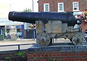 A large Russian gun is located at Welling corner. This Russian weapon is a 36-pounder carronade (calibre 6.75 inches - weight 17 cwt) of a type used during the Crimean War
(1854 to 1860), displayed on a simple wooden replica carriage. The carronade was in service from 1780 to 1860 and is now on loan from the Royal Artillery Museum in Woolwich
as a reminder of Welling's early association with the Royal Arsenal
, Woolwich, when huts at East Wickham were built as homes for munitions workers in the Great War.
For five years after 1990, the headquarters of the far-right British National Party
(formed in 1982) were based in Welling. The presence of the party in Welling sparked a rise in racially motivated crime in the area and several nearby communities. At least three people from ethnic minorities - Afro-Caribbeans Rolan Adams and Stephen Lawrence and Asia
n Sikh
Rohit Duggal - were murdered in the local area within three years of the British National Party's arrival.. Bexley Council shut down the BNP Headquarters in 1995
In 1992 a group of local people, led by local Councillor Nigel Betts, revived the old Memorial Hall Trust which was set up in 1921. In 1995 it started operation as a local grant giving charity called the East Wickham & Welling War Memorial Trust[1] using the revenue from the old hall to fund grants in the area. Its main aim is remember the men of the district who were killed in World War One so a new War Memorial was built in 1996. Its charitable aim is to help local groups with rents on their meeting places or to help groups maintain their halls. Other grants help young people adventurous activities.In 2006 it gave grants totaling £47,000. As part of a re-investment programme, the Trust sold the Hall for re-development in 2007.
A major upgrade of paving and street lighting was completed in the autumn of 2005. The retention or removal of a section of westbound bus lane from Welling High Street became one of the few specific local issues on which the main political parties disagreed in the approach to the local Bexley Council elections held on 4 May 2006. The incoming Conservative administration immediately revoked the bus lane.
The MECCA bingo hall in Upper Wickham Lane
has ceased trading, apparently one of nine in England unsuited to operate after the national ban on smoking in public places. This large building, which originally was an Odeon cinema is operating now as Freedom Centre International, a Pentecostal Church. Rosebys, the Co-op and Tesco's old store all closed since 2007, as has the pub near the station (formerly the Station Hotel) lately known as Inferno's. Live music is performed occasionally at a Greek restaurant, at The Duchess of Edinburgh public house and, towards Plumstead Common
, at The Glenmore Arms.
The Old Koffi Pot café, dates from the 1930s and was until the early 1990s known as 'Ferrara's'. The venue was well-known locally for its ice cream and enjoyed its heyday at the height of the 1960s cafe culture, when young people from Kent
and SE London
would call in for refreshments on the way to or from dancing at the Embassy Ballroom (demolished to make way for the building of Embassy Court). The café was closed during 2009 for 'economic reasons', but a modern coffee shop has since opened in its place retaining the name The Koffi Shop but a brand new black frontage and interior decor have abruptly erased any historical link with the original establishment.
Welling has several Transport For London
(TfL) contracted routes forming an extensive bus network. London Buses route 51
will take you to north to Woolwich via Plumstead Common or south through Blackfen and Sidcup to Orpington, route 89
, operates between Lewisham and Slade Green, Route 96
runs between Woolwich and Bluewater, Route 486 between Bexleyheath and North Greenwich (the O2), route B15 between Bexleyheath (Shopping Centre) and Horn Park (Alnwich Road) via Eltham High Street, and route B16 links Bexleyheath to Kidbrooke via Eltham High Street. Welling is also served by a night bus route, the London Buses route N89, which starts at Erith, running via Slade Green, Barnehurst, Bexleyheath, Welling and Lewisham, towards Trafalgar Square. Several registed minicab companies are based in Welling.
London Borough of Bexley
The London Borough of Bexley lies in south east Greater London, and is a borough referred to as part of Outer London. It has common borders with the London Borough of Bromley to the south, the London Borough of Greenwich to the west, across the River Thames to the north it borders the London...
, South East London. It is a suburb
Suburb
The word suburb mostly refers to a residential area, either existing as part of a city or as a separate residential community within commuting distance of a city . Some suburbs have a degree of administrative autonomy, and most have lower population density than inner city neighborhoods...
an development situated between Shooter's Hill
Shooter's Hill
Shooter's Hill is a district and electoral ward in south London, England, located in the London Borough of Greenwich. It lies east of Blackheath and west of Welling, south of Woolwich and north of Eltham...
and Bexleyheath
Bexleyheath
Bexleyheath is a main suburban district of Southeast London, England, in the London Borough of Bexley with a small percentage of the district itself being in the London Borough of Greenwich. Bexleyheath is located on the border of Inner London and Outer London. It is east south-east of Charing Cross...
north of the A2 road
A2 road (Great Britain)
The A2 is a major road in southern England, connecting London with the English Channel port of Dover in Kent. This route has always been of importance as a connection between the British capital of London and sea trade routes to Continental Europe...
and 10.5 miles (16.9 km) east south-east of Charing Cross
Charing Cross
Charing Cross denotes the junction of Strand, Whitehall and Cockspur Street, just south of Trafalgar Square in central London, England. It is named after the now demolished Eleanor cross that stood there, in what was once the hamlet of Charing. The site of the cross is now occupied by an equestrian...
.
History
The East WickhamEast Wickham
East Wickham is a place and electoral ward in the London Borough of Bexley. It is a part of the Welling post town.-History:Welling originally formed part of the ancient manor of East Wickham, which was centred on St Michael’s Church, Upper Wickham Lane, built in the 13th century...
part of Welling is probably one of the oldest settlements in this area. A Neolithic stone axe was found in East Wickham
East Wickham
East Wickham is a place and electoral ward in the London Borough of Bexley. It is a part of the Welling post town.-History:Welling originally formed part of the ancient manor of East Wickham, which was centred on St Michael’s Church, Upper Wickham Lane, built in the 13th century...
in 1910 and more recently in 1989 the remains of Roman buildings were unearthed near Danson.
Before the coming of the railway, with the opening of the Bexleyheath Line
Bexleyheath Line
The Bexleyheath Line runs for 8 miles from Blackheath to Dartford in Kent operating between the North Kent Line just to the east of Blackheath station and to the same line south of Slade Green in Dartford.-History:...
on 1 May 1895, Welling was a village on the main road between London and Kent
Kent
Kent is a county in southeast England, and is one of the home counties. It borders East Sussex, Surrey and Greater London and has a defined boundary with Essex in the middle of the Thames Estuary. The ceremonial county boundaries of Kent include the shire county of Kent and the unitary borough of...
(Watling Street
Watling Street
Watling Street is the name given to an ancient trackway in England and Wales that was first used by the Britons mainly between the modern cities of Canterbury and St Albans. The Romans later paved the route, part of which is identified on the Antonine Itinerary as Iter III: "Item a Londinio ad...
). It had been a traditional staging post for coaches; the presence of three inns along the main road is the result of that.
After World War I
World War I
World War I , which was predominantly called the World War or the Great War from its occurrence until 1939, and the First World War or World War I thereafter, was a major war centred in Europe that began on 28 July 1914 and lasted until 11 November 1918...
, Bexley Urban District Council
Municipal Borough of Bexley
Bexley was a local government district in north west Kent from 1879 to 1965 around the town of Old Bexley.-History:The parish of Bexley adopted the Local Government Act 1858 in 1879, and a local board of 15 members was formed to govern the area...
built over 400 houses north of the railway. Later, when the Danson
Danson House
Danson House is a Georgian mansion at the centre of Danson Park, to the west of Bexleyheath in the London Borough of Bexley, south-east London.-18th Century:...
estate was sold to developers, the land to the south was opened up to suburban sprawl and the settlement incorporated the local parishes of St Michael's East Wickham and St Johns Welling.
Local legend has it that Welling is so called because by the time you reached it you were "well in" to Kent, and had thus survived the treacherous coach road up and down Shooters Hill, the highwaymen who were said to frequent it, and the forests which until the 1800s stretched almost down to Blackfen.
Welling today
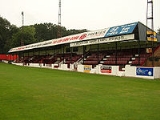
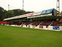
Welling is home to a football ground Welling United F.C.Welling United F.C.
Welling United Football Club are an English football club, based in Welling in the London Borough of Bexley. They currently play in the Conference South. The 2010–11 season was not a good one for them as the club had financial problems, nearly going bankrupt but lots of supporters chipped in and...
which is also shared with the Erith and Belvedere F.C., a refurbished reference and lending library with an IT educational and training room, free use of Internet and toilets, a Masonic Hall, a Martial Arts Academy, an Academy of Performing Arts, a Snooker Hall, Bellegrove Social Club, an Age Concern pop-in parlour, and a Salvation Army Chapel.
Watling Street
Watling Street is the name given to an ancient trackway in England and Wales that was first used by the Britons mainly between the modern cities of Canterbury and St Albans. The Romans later paved the route, part of which is identified on the Antonine Itinerary as Iter III: "Item a Londinio ad...
), Upper Wickham Lane
Upper Wickham Lane
The A209 road is a route in southeast London, England. It connects Plumstead in the north with Welling in the south, passing through East Wickham. It is known as Wickham Lane at the northern end in the London Borough of Greenwich and Upper Wickham Lane at the southern end in the London Borough of...
, and Bellegrove Road and several local supermarkets, namely: Iceland, Morrison's, Shell (petrol station), Lidl and a well-stocked Turkish Food Centre (TFC).
On 8 November 2010 a new Tesco supermarket was opened, along with new apartments above the store. A lift has been built for residents to access the shops and high street. A new bus stop has been built directly outside the shop which currently only serves the 96 bus. The new Tesco includes a meat and fish counter, a hot chicken counter, a hot pie cabinet, a take-away food counter, a Krispy Kreme doughnut counter and a Costa Coffie shop. It also includes a clothing department selling F&F style clothes and other items.
The Co-op Superstore opposite (formerly operated by the Royal Arsenal Co-operative Society) ceased trading on 19 September 2008 and was redeveloped as a Morrison's supermarket that opened on 16 November 2009.
The former Foster's School building in Upper Wickham Lane
Upper Wickham Lane
The A209 road is a route in southeast London, England. It connects Plumstead in the north with Welling in the south, passing through East Wickham. It is known as Wickham Lane at the northern end in the London Borough of Greenwich and Upper Wickham Lane at the southern end in the London Borough of...
is a local landmark. The school relocated to Westbrooke Road in Welling and its original site was converted to residential use (retaining the old Grade II listed main school building and headmaster's house). Further north of the original site is an ancient church, now used by a Greek Orthodox
Eastern Orthodox Church
The Orthodox Church, officially called the Orthodox Catholic Church and commonly referred to as the Eastern Orthodox Church, is the second largest Christian denomination in the world, with an estimated 300 million adherents mainly in the countries of Belarus, Bulgaria, Cyprus, Georgia, Greece,...
congregation.
Crimean War
The Crimean War was a conflict fought between the Russian Empire and an alliance of the French Empire, the British Empire, the Ottoman Empire, and the Kingdom of Sardinia. The war was part of a long-running contest between the major European powers for influence over territories of the declining...
(1854 to 1860), displayed on a simple wooden replica carriage. The carronade was in service from 1780 to 1860 and is now on loan from the Royal Artillery Museum in Woolwich
Woolwich
Woolwich is a district in south London, England, located in the London Borough of Greenwich. The area is identified in the London Plan as one of 35 major centres in Greater London.Woolwich formed part of Kent until 1889 when the County of London was created...
as a reminder of Welling's early association with the Royal Arsenal
Royal Arsenal
The Royal Arsenal, Woolwich, originally known as the Woolwich Warren, carried out armaments manufacture, ammunition proofing and explosives research for the British armed forces. It was sited on the south bank of the River Thames in Woolwich in south-east London, England.-Early history:The Warren...
, Woolwich, when huts at East Wickham were built as homes for munitions workers in the Great War.
For five years after 1990, the headquarters of the far-right British National Party
British National Party
The British National Party is a British far-right political party formed as a splinter group from the National Front by John Tyndall in 1982...
(formed in 1982) were based in Welling. The presence of the party in Welling sparked a rise in racially motivated crime in the area and several nearby communities. At least three people from ethnic minorities - Afro-Caribbeans Rolan Adams and Stephen Lawrence and Asia
Asia
Asia is the world's largest and most populous continent, located primarily in the eastern and northern hemispheres. It covers 8.7% of the Earth's total surface area and with approximately 3.879 billion people, it hosts 60% of the world's current human population...
n Sikh
Sikh
A Sikh is a follower of Sikhism. It primarily originated in the 15th century in the Punjab region of South Asia. The term "Sikh" has its origin in Sanskrit term शिष्य , meaning "disciple, student" or शिक्ष , meaning "instruction"...
Rohit Duggal - were murdered in the local area within three years of the British National Party's arrival.. Bexley Council shut down the BNP Headquarters in 1995
In 1992 a group of local people, led by local Councillor Nigel Betts, revived the old Memorial Hall Trust which was set up in 1921. In 1995 it started operation as a local grant giving charity called the East Wickham & Welling War Memorial Trust[1] using the revenue from the old hall to fund grants in the area. Its main aim is remember the men of the district who were killed in World War One so a new War Memorial was built in 1996. Its charitable aim is to help local groups with rents on their meeting places or to help groups maintain their halls. Other grants help young people adventurous activities.In 2006 it gave grants totaling £47,000. As part of a re-investment programme, the Trust sold the Hall for re-development in 2007.
A major upgrade of paving and street lighting was completed in the autumn of 2005. The retention or removal of a section of westbound bus lane from Welling High Street became one of the few specific local issues on which the main political parties disagreed in the approach to the local Bexley Council elections held on 4 May 2006. The incoming Conservative administration immediately revoked the bus lane.
The MECCA bingo hall in Upper Wickham Lane
Upper Wickham Lane
The A209 road is a route in southeast London, England. It connects Plumstead in the north with Welling in the south, passing through East Wickham. It is known as Wickham Lane at the northern end in the London Borough of Greenwich and Upper Wickham Lane at the southern end in the London Borough of...
has ceased trading, apparently one of nine in England unsuited to operate after the national ban on smoking in public places. This large building, which originally was an Odeon cinema is operating now as Freedom Centre International, a Pentecostal Church. Rosebys, the Co-op and Tesco's old store all closed since 2007, as has the pub near the station (formerly the Station Hotel) lately known as Inferno's. Live music is performed occasionally at a Greek restaurant, at The Duchess of Edinburgh public house and, towards Plumstead Common
Plumstead Common
Plumstead Common is a common in Plumstead, in the London Borough of Greenwich, south-east London. It is bound to the north by Old Mill Road and to the south by Plumstead Common Road. To the east lies Winn or Winn's Common...
, at The Glenmore Arms.
The Old Koffi Pot café, dates from the 1930s and was until the early 1990s known as 'Ferrara's'. The venue was well-known locally for its ice cream and enjoyed its heyday at the height of the 1960s cafe culture, when young people from Kent
Kent
Kent is a county in southeast England, and is one of the home counties. It borders East Sussex, Surrey and Greater London and has a defined boundary with Essex in the middle of the Thames Estuary. The ceremonial county boundaries of Kent include the shire county of Kent and the unitary borough of...
and SE London
SE postcode area
The SE postcode area, also known as the London SE postcode area, is the part of the London post town covering part of south east London, England...
would call in for refreshments on the way to or from dancing at the Embassy Ballroom (demolished to make way for the building of Embassy Court). The café was closed during 2009 for 'economic reasons', but a modern coffee shop has since opened in its place retaining the name The Koffi Shop but a brand new black frontage and interior decor have abruptly erased any historical link with the original establishment.
Notable Past Residents
- Kate BushKate BushKate Bush is an English singer-songwriter, musician and record producer. Her eclectic musical style and idiosyncratic vocal style have made her one of the United Kingdom's most successful solo female performers of the past 30 years.In 1978, at the age of 19, Bush topped the UK Singles Chart...
, world-famous singer/songwriter - Sheila HancockSheila HancockSheila Cameron Hancock, CBE is an English actress and author.-Early life:Sheila Hancock was born in Blackgang on the Isle of Wight, the daughter of Ivy Louise and Enrico Cameron Hancock, who was a publican. Her sister Billie is seven years older...
, famous actress (and widow of actor John ThawJohn ThawJohn Edward Thaw, CBE was an English actor, who appeared in a range of television, stage and cinema roles, his most popular being police and legal dramas such as Redcap, The Sweeney, Inspector Morse and Kavanagh QC.-Early life:Thaw came from a working class background, having been born in Gorton,...
) grew up in neighbouring BexleyheathBexleyheathBexleyheath is a main suburban district of Southeast London, England, in the London Borough of Bexley with a small percentage of the district itself being in the London Borough of Greenwich. Bexleyheath is located on the border of Inner London and Outer London. It is east south-east of Charing Cross...
, and celebrated the reception of her first marriage (to Alec Ross in 1954) at the Embassy Ballrooms, on the site of the recently-demolished Embassy Court.
Education
- For information about the following schools and colleges in Welling see the main London Borough of Bexley article
- Bexley Grammar SchoolBexley Grammar SchoolBexley Grammar School, is a co-educational grammar school in Welling, in the London Borough of Bexley, UK. Students are admitted into Year 7 at age 11, however can be admitted at a younger age of 10 if the student skipped a year or into the Sixth Form at age 16, providing they fulfil the entry...
- Bishop Ridley CofE Primary School (formerly Westwood Primary School)
- Danson Primary School
- East Wickham Infants School
- East Wickham Junior School
- Eastcote Primary School
- Foster Primary School
- Harris Academy FalconwoodHarris Academy FalconwoodHarris Academy Falconwood is a city academy in Falconwood, London, England. The school is a mixed gender school and accepts students based on various mental attributes.-Harris Federation:...
(formerly Westwood College) - Hillsgrove Primary School
- Hook Lane Primary School
- St.Michael's East Wickham CoE Primary School
- St.Stephen's Catholic Primary School
- Townley Grammar School For Girls
- Welling School
- Westbrooke School
Transport
Welling railway station is close to Central Avenue at the western edge of the town centre and offers direct rail links to London Bridge, Charing Cross, Victoria and Cannon Street Stations in Central London, and to Dartford and other towns in North Kent.Welling has several Transport For London
Transport for London
Transport for London is the local government body responsible for most aspects of the transport system in Greater London in England. Its role is to implement the transport strategy and to manage transport services across London...
(TfL) contracted routes forming an extensive bus network. London Buses route 51
London Buses route 51
London Buses route 51 is a Transport for London contracted bus route in London, United Kingdom. The service is currently contracted to Stagecoach London.-History:...
will take you to north to Woolwich via Plumstead Common or south through Blackfen and Sidcup to Orpington, route 89
London Buses route 89
London Buses route 89 is a Transport for London contracted bus route in London, United Kingdom. The service is currently contracted to Go-Ahead London.-History:...
, operates between Lewisham and Slade Green, Route 96
London Buses route 96
London Buses route 96 is a Transport for London contracted bus route in London, United Kingdom. The service is currently contracted to Stagecoach London.-History:...
runs between Woolwich and Bluewater, Route 486 between Bexleyheath and North Greenwich (the O2), route B15 between Bexleyheath (Shopping Centre) and Horn Park (Alnwich Road) via Eltham High Street, and route B16 links Bexleyheath to Kidbrooke via Eltham High Street. Welling is also served by a night bus route, the London Buses route N89, which starts at Erith, running via Slade Green, Barnehurst, Bexleyheath, Welling and Lewisham, towards Trafalgar Square. Several registed minicab companies are based in Welling.
Nearest railway stations
- Bexleyheath railway stationBexleyheath railway stationBexleyheath railway station is in the London Borough of Bexley in south east London, and is in Travelcard Zone 5. The station, and all trains serving it, is operated by Southeastern...
- Falconwood railway stationFalconwood railway stationFalconwood railway station is situated in the suburb of Falconwood, London Borough of Bexley, and is served by the Bexleyheath Line: it is about 10 miles from Central London. The station was opened much later than the remainder of the line, on 1 January 1936, to serve a growing area...
- Welling railway stationWelling railway stationWelling railway station is situated in Welling, part of the London Borough of Bexley, and is served by the Bexleyheath Line, 11.4 miles from Central London....
Nearest places
- Abbey WoodAbbey WoodAbbey Wood is a district of South-East London, England, located mostly in the London Borough of Greenwich, and partly within the London Borough of Bexley. It is situated east of Charing Cross.-Development:...
- BexleyBexleyBexley is an South East London]] in the London Borough of Bexley, London, England. It is located on the banks of the River Cray south of the Roman Road, Watling Street...
- BexleyheathBexleyheathBexleyheath is a main suburban district of Southeast London, England, in the London Borough of Bexley with a small percentage of the district itself being in the London Borough of Greenwich. Bexleyheath is located on the border of Inner London and Outer London. It is east south-east of Charing Cross...
- BlackfenBlackfenBlackfen is a largely residential area of Sidcup in the London Borough of Bexley, South East London; and makes part of the electoral ward of Blackfen and Lamorbey Ward along with Lamorbey. It is situated 10.2 miles east south-east of Charing Cross. The word "Blackfen" means a black, marshy area...
- East WickhamEast WickhamEast Wickham is a place and electoral ward in the London Borough of Bexley. It is a part of the Welling post town.-History:Welling originally formed part of the ancient manor of East Wickham, which was centred on St Michael’s Church, Upper Wickham Lane, built in the 13th century...
- Eltham
- FalconwoodFalconwood-Southeastern Train Services:Nearest Train Stations* Falconwood railway station, Lingfield Crescent, Eltham, London, SE9 2RN.* Eltham railway station, Well Hall Road, Eltham, London, SE9 6SL....
- PlumsteadPlumsteadPlumstead is a district of south London, England, located in the London Borough of Greenwich. Plumstead is a multi cultural area with large Asian and Afro-Caribbean communities, in similarity to local areas such as Woolwich and Thamesmead...
- Shooter's HillShooter's HillShooter's Hill is a district and electoral ward in south London, England, located in the London Borough of Greenwich. It lies east of Blackheath and west of Welling, south of Woolwich and north of Eltham...
- SidcupSidcupSidcup is a district in South East London in the London Borough of Bexley and small parts of the district in the London Borough of Greenwich.Located south east of Charing Cross, Sidcup is bordered by the London Boroughs of Greenwich and Bromley and Kent County Council, and whilst now part of...