

Cable Street
Encyclopedia
Cable Street is a mile-long road in the East End of London
, with several historic landmarks nearby, made famous by "the Battle of Cable Street
" of 1936.
and Limehouse
:
parallel to, and south of, the Docklands Light Railway
and Commercial Road
, and north of The Highway
.
The area is close to Wapping
and Shadwell Basin
(to the south), Tower Hill (to the west), and Whitechapel
and Stepney
(to the north).
Since many Londoners now define their locality by the nearest tube stations, this area is often referred to as Shadwell
.
Cable Street is in the London Borough of Tower Hamlets
, in postal district E1
.
It lies within the parliamentary constituencies of Bethnal Green and Bow
and Poplar and Canning Town,
currently represented by Rushanara Ali
and Jim Fitzpatrick
, both of the Labour
party.
, between London Bridge
and Wapping
& Rotherhithe
. Many other "rope walks" can be seen on later maps, showing how demand for ropes grew as shipping increased.
Until Victorian times, the current Cable Street had different names for each of its sections. From west to east these ran: "Cable Street", "Knock Fergus", "New Road", "Back Lane", "Blue Gate Fields", "Sun Tavern Fields", "Brook Street".
Knock Fergus may be a reference to the large numbers of Irish residents there then, but the name is old -- it is found in the St Dunstan Stepney registers in the early 1600s.
Also, in the 19th century, the area at the western end was identified as "near Wellclose Square
", as this was a well-known landmark, where nautical items were sold.
The whole of the central area of the current street was named after St George in the East
church and St George in the East
parish.
From Victorian times through to the 1950s, Cable Street had a reputation for cheap lodgings, brothels, drinking inns and opium dens.
The last occasion in England
when a stake was hammered through a sinner’s heart at an official burial, took place at the junction of Cable Street and Cannon Street Road. John Williams was found hanged in his cell, after being arrested as a suspect in the Ratcliff Highway murders
. Local people went along with the claim that he had committed suicide, from guilt of the crimes. At the time, 1812, suicide was considered to be sinful, and justified him being buried upside down with a stake through his heart. His skull was found when new gas mains were being laid in the 1960s, and was on display for many years in The Crown and Dolphin pub opposite.
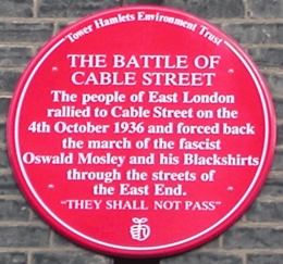 In 1936, a violent confrontation between the police and local communities, was later named the Battle of Cable Street
. Communist, Anarchist, Labour and Jewish groups joined with locals to resist a planned march through the East End by the British Union of Fascists
. A large mural on St George's Town Hall next to Library Place, depicts scenes from the day. A red plaque in Dock Street commemorates the incident.
Motor traffic is restricted to travel one-way along the whole street, though the direction varies. It is mostly west-bound, but it is east-bound east of Brodlove Lane (itself one-way north-bound). It lies outside of the London congestion charge
zone.
Bicycle
London Cycle SuperHighway 3 runs the length of cable street in the form of a two-way segregated cycle track
, continuing west into Royal Mint Street; its western terminus. This is well used by cyclists, especially those commuting to both the City and Docklands.
Bus
Buses 100 and D3 both pass west-bound through the central part of Cable Street:
Rail
The district falls within Transport for London
's Travelcard Zone 2
. The nearest London Underground station is Tower Hill
. Opening in 2010, the nearest London Overground
stations are Shadwell
and Wapping
on the East London line
.
The nearest Docklands Light Railway stations are Shadwell
and Limehouse
National Rail
stations:
Politicians
Members of Parliament, for Bethnal Green and Bow :
Members of Parliament, for Poplar and Canning Town :
Science and Medicine
Sports

Literary figures
Victorian Era:
Edwardian Era:
People inspiring local street names
north of Cable Street starting from the west:
east of Cable Street
south of Cable Street, starting from the west:
East End of London
The East End of London, also known simply as the East End, is the area of London, England, United Kingdom, east of the medieval walled City of London and north of the River Thames. Although not defined by universally accepted formal boundaries, the River Lea can be considered another boundary...
, with several historic landmarks nearby, made famous by "the Battle of Cable Street
Battle of Cable Street
The Battle of Cable Street took place on Sunday 4 October 1936 in Cable Street in the East End of London. It was a clash between the Metropolitan Police, overseeing a march by the British Union of Fascists, led by Oswald Mosley, and anti-fascists, including local Jewish, socialist, anarchist,...
" of 1936.
Location
Cable Street runs between the edge of The CityCity of London
The City of London is a small area within Greater London, England. It is the historic core of London around which the modern conurbation grew and has held city status since time immemorial. The City’s boundaries have remained almost unchanged since the Middle Ages, and it is now only a tiny part of...
and Limehouse
Limehouse
Limehouse is a place in the London Borough of Tower Hamlets. It is on the northern bank of the River Thames opposite Rotherhithe and between Ratcliff to the west and Millwall to the east....
:
parallel to, and south of, the Docklands Light Railway
Docklands Light Railway
The Docklands Light Railway is an automated light metro or light rail system opened on 31 August 1987 to serve the redeveloped Docklands area of London...
and Commercial Road
Commercial Road
Commercial Road , in length, is in the London Borough of Tower Hamlets in the East End of London. It runs from "Gardener's Corner" , through Stepney to the junction with Burdett Road , Limehouse from which point the route becomes the East India Dock Road...
, and north of The Highway
The Highway
The Highway, formerly known as the Ratcliffe Highway, is a mile-long road in the East End of London, with several historic landmarks nearby. The route dates back to Roman times. In the 19th century it had a very notorious reputation for vice and crime and was the site of the infamous Ratcliff...
.
The area is close to Wapping
Wapping
Wapping is a place in the London Borough of Tower Hamlets which forms part of the Docklands to the east of the City of London. It is situated between the north bank of the River Thames and the ancient thoroughfare simply called The Highway...
and Shadwell Basin
Shadwell Basin
Shadwell Basin was part of the London Docks, a group of docks built by the London Dock Company at Wapping, London, and part of the wider docks of the Port of London....
(to the south), Tower Hill (to the west), and Whitechapel
Whitechapel
Whitechapel is a built-up inner city district in the London Borough of Tower Hamlets, London, England. It is located east of Charing Cross and roughly bounded by the Bishopsgate thoroughfare on the west, Fashion Street on the north, Brady Street and Cavell Street on the east and The Highway on the...
and Stepney
Stepney
Stepney is a district of the London Borough of Tower Hamlets in London's East End that grew out of a medieval village around St Dunstan's church and the 15th century ribbon development of Mile End Road...
(to the north).
Since many Londoners now define their locality by the nearest tube stations, this area is often referred to as Shadwell
Shadwell
Shadwell is an inner-city district situated within the London Borough of Tower Hamlets located on the north bank of the Thames between Wapping to the south and Ratcliff to the east...
.
Cable Street is in the London Borough of Tower Hamlets
London Borough of Tower Hamlets
The London Borough of Tower Hamlets is a London borough to the east of the City of London and north of the River Thames. It is in the eastern part of London and covers much of the traditional East End. It also includes much of the redeveloped Docklands region of London, including West India Docks...
, in postal district E1
London E1
The E postcode area, also known as the London E postcode area, is the part of the London post town covering part of east London, England and also Sewardstone in Essex.-Postal administration:...
.
It lies within the parliamentary constituencies of Bethnal Green and Bow
and Poplar and Canning Town,
currently represented by Rushanara Ali
Rushanara Ali
Rushanara Ali is a British Labour Party politician and Associate Director of the Young Foundation, who has been the Member of Parliament for Bethnal Green and Bow since 2010...
and Jim Fitzpatrick
Jim Fitzpatrick (politician)
James Fitzpatrick is a British Labour Party politician, who has been the Member of Parliament for Poplar and Limehouse since the 2010 General Election. From 1997 to the 2010 election he was the member for Poplar and Canning Town...
, both of the Labour
Labour Party (UK)
The Labour Party is a centre-left democratic socialist party in the United Kingdom. It surpassed the Liberal Party in general elections during the early 1920s, forming minority governments under Ramsay MacDonald in 1924 and 1929-1931. The party was in a wartime coalition from 1940 to 1945, after...
party.
History
Cable Street started as a straight path along which hemp ropes were twisted into ships cables (i.e. ropes). These supplied the many ships that would anchor in the nearby Pool of LondonPool of London
The Pool of London is a part of the Tideway of the River Thames from London Bridge to below Tower Bridge. It was the original part of the Port of London. The Pool of London is divided into two parts, the Upper Pool and Lower Pool...
, between London Bridge
London Bridge
London Bridge is a bridge over the River Thames, connecting the City of London and Southwark, in central London. Situated between Cannon Street Railway Bridge and Tower Bridge, it forms the western end of the Pool of London...
and Wapping
Wapping
Wapping is a place in the London Borough of Tower Hamlets which forms part of the Docklands to the east of the City of London. It is situated between the north bank of the River Thames and the ancient thoroughfare simply called The Highway...
& Rotherhithe
Rotherhithe
Rotherhithe is a residential district in inner southeast London, England and part of the London Borough of Southwark. It is located on a peninsula on the south bank of the Thames, facing Wapping and the Isle of Dogs on the north bank, and is a part of the Docklands area...
. Many other "rope walks" can be seen on later maps, showing how demand for ropes grew as shipping increased.
Until Victorian times, the current Cable Street had different names for each of its sections. From west to east these ran: "Cable Street", "Knock Fergus", "New Road", "Back Lane", "Blue Gate Fields", "Sun Tavern Fields", "Brook Street".
Knock Fergus may be a reference to the large numbers of Irish residents there then, but the name is old -- it is found in the St Dunstan Stepney registers in the early 1600s.
Also, in the 19th century, the area at the western end was identified as "near Wellclose Square
Wellclose Square
Wellclose Square lies in the London Borough of Tower Hamlets, between Cable Street to the north and The Highway to the south.The western edge, now called Ensign Street, was previously called Well Street. The southern edge was called Neptune street. On the north side is Graces Alley, home to...
", as this was a well-known landmark, where nautical items were sold.
The whole of the central area of the current street was named after St George in the East
St George in the East
St George in the East is an Anglican Church and one of six Hawksmoor churches in London, England, built from 1714 to 1729, with funding from the 1711 Act of Parliament...
church and St George in the East
St George in the East (parish)
St George in the East was a parish in the metropolitan area of London, England.-History:The parish was largely rural at the time of its creation, the main settlement a hamlet known as Wapping Stepney...
parish.
From Victorian times through to the 1950s, Cable Street had a reputation for cheap lodgings, brothels, drinking inns and opium dens.
The last occasion in England
England
England is a country that is part of the United Kingdom. It shares land borders with Scotland to the north and Wales to the west; the Irish Sea is to the north west, the Celtic Sea to the south west, with the North Sea to the east and the English Channel to the south separating it from continental...
when a stake was hammered through a sinner’s heart at an official burial, took place at the junction of Cable Street and Cannon Street Road. John Williams was found hanged in his cell, after being arrested as a suspect in the Ratcliff Highway murders
Ratcliff Highway murders
The Ratcliff Highway murders were two vicious attacks that resulted in multiple fatalities, and occurred over twelve days in the year 1811, in homes half a mile apart near Wapping in London.-Murders:...
. Local people went along with the claim that he had committed suicide, from guilt of the crimes. At the time, 1812, suicide was considered to be sinful, and justified him being buried upside down with a stake through his heart. His skull was found when new gas mains were being laid in the 1960s, and was on display for many years in The Crown and Dolphin pub opposite.
Battle of Cable Street
The Battle of Cable Street took place on Sunday 4 October 1936 in Cable Street in the East End of London. It was a clash between the Metropolitan Police, overseeing a march by the British Union of Fascists, led by Oswald Mosley, and anti-fascists, including local Jewish, socialist, anarchist,...
. Communist, Anarchist, Labour and Jewish groups joined with locals to resist a planned march through the East End by the British Union of Fascists
British Union of Fascists
The British Union was a political party in the United Kingdom formed in 1932 by Sir Oswald Mosley as the British Union of Fascists, in 1936 it changed its name to the British Union of Fascists and National Socialists and then in 1937 to simply the British Union...
. A large mural on St George's Town Hall next to Library Place, depicts scenes from the day. A red plaque in Dock Street commemorates the incident.
Landmarks
(west to east)- Wilton's Music HallWilton's Music HallWilton's Music Hall is a grade II* listed building, built as a music hall and now a more general-purpose performance space in Grace's Alley, off Cable Street in the London Borough of Tower Hamlets...
- the world's oldest surviving grand music hall - Wellclose SquareWellclose SquareWellclose Square lies in the London Borough of Tower Hamlets, between Cable Street to the north and The Highway to the south.The western edge, now called Ensign Street, was previously called Well Street. The southern edge was called Neptune street. On the north side is Graces Alley, home to...
- The Crown and Dolphin (ex-pub)
- Church of St George in the EastSt George in the East (parish)St George in the East was a parish in the metropolitan area of London, England.-History:The parish was largely rural at the time of its creation, the main settlement a hamlet known as Wapping Stepney...
- terrace of Georgian Houses, nos. 192-232
- The Britannia (ex-pub)
- St George's Recreation Ground
- Mural of the Battle of Cable StreetBattle of Cable StreetThe Battle of Cable Street took place on Sunday 4 October 1936 in Cable Street in the East End of London. It was a clash between the Metropolitan Police, overseeing a march by the British Union of Fascists, led by Oswald Mosley, and anti-fascists, including local Jewish, socialist, anarchist,...
- St George's Hall - the old town hall
- St Georges Swimming Pool
- Shadwell tube station
- Shadwell DLR station
- Watney Market
- Shadwell Fire Station
- Blue Gate fields primary school
- St Mary's church
- terrace of Georgian cottages
- Kings Arms - the only pub left in the street, which has now been demolished
- Cable Street Studios - artists workshops
Transport
RoadMotor traffic is restricted to travel one-way along the whole street, though the direction varies. It is mostly west-bound, but it is east-bound east of Brodlove Lane (itself one-way north-bound). It lies outside of the London congestion charge
London congestion charge
The London congestion charge is a fee charged for some categories of motor vehicle to travel at certain times within the Congestion Charge Zone , a traffic area in London. The charge aims to reduce congestion, and raise investment funds for London's transport system...
zone.
Bicycle
London Cycle SuperHighway 3 runs the length of cable street in the form of a two-way segregated cycle track
Segregated cycle facilities
Segregated cycle facilities are marked lanes, tracks, shoulders and paths designated for use by cyclists from which motorised traffic is generally excluded...
, continuing west into Royal Mint Street; its western terminus. This is well used by cyclists, especially those commuting to both the City and Docklands.
Bus
Buses 100 and D3 both pass west-bound through the central part of Cable Street:
- 100 connects to WappingWappingWapping is a place in the London Borough of Tower Hamlets which forms part of the Docklands to the east of the City of London. It is situated between the north bank of the River Thames and the ancient thoroughfare simply called The Highway...
, Liverpool StreetLiverpool Street stationLiverpool Street railway station, also known as London Liverpool Street or simply Liverpool Street, is both a central London railway terminus and a connected London Underground station in the north-eastern corner of the City of London, England...
, St PaulsSt Paul's CathedralSt Paul's Cathedral, London, is a Church of England cathedral and seat of the Bishop of London. Its dedication to Paul the Apostle dates back to the original church on this site, founded in AD 604. St Paul's sits at the top of Ludgate Hill, the highest point in the City of London, and is the mother...
and Elephant and CastleElephant and CastleThe Elephant and Castle is a major road intersection in south London, England, located in the London Borough of Southwark. It is also used as a name for the surrounding area....
. - D3 connects to Isle of DogsIsle of DogsThe Isle of Dogs is a former island in the East End of London that is bounded on three sides by one of the largest meanders in the River Thames.-Etymology:...
, LimehouseLimehouseLimehouse is a place in the London Borough of Tower Hamlets. It is on the northern bank of the River Thames opposite Rotherhithe and between Ratcliff to the west and Millwall to the east....
, WappingWappingWapping is a place in the London Borough of Tower Hamlets which forms part of the Docklands to the east of the City of London. It is situated between the north bank of the River Thames and the ancient thoroughfare simply called The Highway...
and Bethnal GreenBethnal GreenBethnal Green is a district of the East End of London, England and part of the London Borough of Tower Hamlets, with the far northern parts falling within the London Borough of Hackney. Located northeast of Charing Cross, it was historically an agrarian hamlet in the ancient parish of Stepney,...
. - 339 connects to Mile EndMile EndMile End is an area within the East End of London, England, and part of the London Borough of Tower Hamlets. It is located east-northeast of Charing Cross...
, BowBow, LondonBow is an area of London, England, United Kingdom in the London Borough of Tower Hamlets. It is a built-up, mostly residential district located east of Charing Cross, and is a part of the East End.-Bridges at Bowe:...
and Old Ford - from next to the DLR station.
Rail
The district falls within Transport for London
Transport for London
Transport for London is the local government body responsible for most aspects of the transport system in Greater London in England. Its role is to implement the transport strategy and to manage transport services across London...
's Travelcard Zone 2
Travelcard Zone 2
Fare zone 2 is an inner zone of Transport for London's zonal fare system used for calculating the price of tickets for travel on the London Underground, London Overground, Docklands Light Railway and, since 2007, on National Rail services.-Background:...
. The nearest London Underground station is Tower Hill
Tower Hill tube station
Tower Hill is a London Underground station at Tower Hill in the London Borough of Tower Hamlets.The station is in Travelcard Zone 1 and near the Tower of London...
. Opening in 2010, the nearest London Overground
London Overground
London Overground is a suburban rail network in London and Hertfordshire. It has been operated by London Overground Rail Operations since 2007 as part of the National Rail network, under the franchise control and branding of Transport for London...
stations are Shadwell
Shadwell tube station
Shadwell railway station is on the East London Line of London Overground, between to the north and to the south. It is located near to Shadwell DLR station. The station is in Zone 2.-London Underground:...
and Wapping
Wapping tube station
Wapping railway station is on the northern bank of the river Thames in Wapping, East London, England. It is in Zone 2, and on the East London Line of London Overground between and ....
on the East London line
East London Line
The East London Line is a London Overground line which runs north to south through the East End, Docklands and South areas of London.Built in 1869 by the East London Railway Company, which reused the Thames Tunnel, originally intended for horse-drawn carriages, the line became part of the London...
.
The nearest Docklands Light Railway stations are Shadwell
Shadwell DLR station
Shadwell DLR station on the Docklands Light Railway is between the terminals of Bank and Tower Gateway to the west and Limehouse to the east. The 1991 Bank extension joins the main DLR line just to the west of Shadwell.-History:...
and Limehouse
National Rail
National Rail
National Rail is a title used by the Association of Train Operating Companies as a generic term to define the passenger rail services operated in Great Britain...
stations:
- Limehouse railway stationLimehouse stationLimehouse station is a railway station located in the Limehouse district of east London. The station is in Travelcard Zone 2 and is served by Docklands Light Railway services and by National Rail services operated by c2c out of Fenchurch Street station...
People
People associated with the area:Politicians
Members of Parliament, for Bethnal Green and Bow :
- Rushanara AliRushanara AliRushanara Ali is a British Labour Party politician and Associate Director of the Young Foundation, who has been the Member of Parliament for Bethnal Green and Bow since 2010...
, LabourLabour Party (UK)The Labour Party is a centre-left democratic socialist party in the United Kingdom. It surpassed the Liberal Party in general elections during the early 1920s, forming minority governments under Ramsay MacDonald in 1924 and 1929-1931. The party was in a wartime coalition from 1940 to 1945, after...
(MP 2010-) - George GallowayGeorge GallowayGeorge Galloway is a British politician, author, journalist and broadcaster who was a Member of Parliament from 1987 to 2010. He was formerly an MP for the Labour Party, first for Glasgow Hillhead and later for Glasgow Kelvin, before his expulsion from the party in October 2003, the same year...
, RespectRESPECT The Unity CoalitionRespect is a socialist political party in England and Wales founded in 2004. Its name is a contrived acronym standing for Respect, Equality, Socialism, Peace, Environmentalism, Community and Trade Unionism.-Policies:...
(MP 2005-2010) - Oona KingOona KingOona Tamsyn King, Baroness King of Bow is a Baroness and Member of the House of Lords, and former Chief Diversity Officer of Channel 4. She previously had served as a Labour Party Member of Parliament for Bethnal Green and Bow from 1997 until 2005, when she was defeated by Respect candidate George...
, LabourLabour Party (UK)The Labour Party is a centre-left democratic socialist party in the United Kingdom. It surpassed the Liberal Party in general elections during the early 1920s, forming minority governments under Ramsay MacDonald in 1924 and 1929-1931. The party was in a wartime coalition from 1940 to 1945, after...
(MP 1997-2005)
Members of Parliament, for Poplar and Canning Town :
- Jim FitzpatrickJim Fitzpatrick (politician)James Fitzpatrick is a British Labour Party politician, who has been the Member of Parliament for Poplar and Limehouse since the 2010 General Election. From 1997 to the 2010 election he was the member for Poplar and Canning Town...
, LabourLabour Party (UK)The Labour Party is a centre-left democratic socialist party in the United Kingdom. It surpassed the Liberal Party in general elections during the early 1920s, forming minority governments under Ramsay MacDonald in 1924 and 1929-1931. The party was in a wartime coalition from 1940 to 1945, after...
(MP 1997- )
Science and Medicine
- Dr Hannah BilligHannah BilligCaptain Hannah Billig, MBE, GM was a British-Jewish doctor who worked in the East End of London. Her popularity with her patients, and her war-time efforts, led to her being called "The Angel of Cable Street".-Childhood:...
(1901–1987) - a local doctor who became known as "The Angel of Cable Street". A blue plaqueBlue plaqueA blue plaque is a permanent sign installed in a public place to commemorate a link between that location and a famous person or event, serving as a historical marker....
marks her home surgery at number 198, near Cannon Street Road.
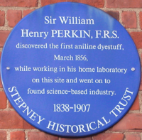
- Sir William Henry Perkin (1838–1907) chemist who discovered anilineAnilineAniline, phenylamine or aminobenzene is an organic compound with the formula C6H5NH2. Consisting of a phenyl group attached to an amino group, aniline is the prototypical aromatic amine. Being a precursor to many industrial chemicals, its main use is in the manufacture of precursors to polyurethane...
purple dye, mauveineMauveineMauveine, also known as aniline purple and Perkin's mauve, was the first synthetic organic chemical dye.Its chemical name is3-amino-2,±9-dimethyl-5-phenyl-7-phenazinium acetate...
, in a hut in the garden of his family's Cable Street home. A blue plaqueBlue plaqueA blue plaque is a permanent sign installed in a public place to commemorate a link between that location and a famous person or event, serving as a historical marker....
marks the site, by the junction with King David Lane.
Sports
- Jack 'Kid' BergJack Kid BergJudah Bergman, known as Jack Kid Berg or Jackie Kid Berg , was an English boxer born in the East End of London.-Biography:Judah Bergman was born in Romford Street near Cable Street, St George in the East, Stepney...
(1909–1991) - Lightweight Champion Boxer, born in Cable Street, by Noble Court
Literary figures
Victorian Era:
- Oscar WildeOscar WildeOscar Fingal O'Flahertie Wills Wilde was an Irish writer and poet. After writing in different forms throughout the 1880s, he became one of London's most popular playwrights in the early 1890s...
visited the opium dens off Cable Street, near Dellow Street - Arthur Conan DoyleArthur Conan DoyleSir Arthur Ignatius Conan Doyle DL was a Scottish physician and writer, most noted for his stories about the detective Sherlock Holmes, generally considered a milestone in the field of crime fiction, and for the adventures of Professor Challenger...
visited the opium dens as research for his detective character Sherlock HolmesSherlock HolmesSherlock Holmes is a fictional detective created by Scottish author and physician Sir Arthur Conan Doyle. The fantastic London-based "consulting detective", Holmes is famous for his astute logical reasoning, his ability to take almost any disguise, and his use of forensic science skills to solve...
.
Edwardian Era:
- Isaac RosenburgIsaac RosenbergIsaac Rosenberg was an English poet of the First World War who was considered to be one of the greatest of all English war poets...
(1890–1918), poet & painter, lived at 47 Cable Street from 1897 to 1900, when he attended St. Paul's School in Wellclose Square.
People inspiring local street names
- Thomas BarnardoThomas John BarnardoThomas John Barnardo was a philanthropist and founder and director of homes for poor children, born in Dublin. From the foundation of the first Barnardo's home in 1870 to the date of Barnardo’s death, nearly 100,000 children had been rescued, trained and given a better life.- Early life :Barnardo...
- Victorian philanthropist who established homes for destitute children - Nicholas HawksmoorNicholas HawksmoorNicholas Hawksmoor was a British architect born in Nottinghamshire, probably in East Drayton.-Life:Hawksmoor was born in Nottinghamshire in 1661, into a yeoman farming family, almost certainly in East Drayton, Nottinghamshire. On his death he was to leave property at nearby Ragnall, Dunham and a...
- architect who designed the church of St George in the East - Nathaniel HeckfordNathaniel HeckfordDr. Nathaniel Heckford was a paediatrician in Victorian London, who founded the East London Hospital for Children. He met his future wife, Sarah Goff, during the 1866 cholera epidemic in Wapping, where he first determined a need for a children's hospital in East London...
- a young doctor who founded a local children's hospital - Harriet MartineauHarriet MartineauHarriet Martineau was an English social theorist and Whig writer, often cited as the first female sociologist....
- Victorian journalist and writer: populariser of political economy - Daniel SolanderDaniel SolanderDaniel Carlsson Solander or Daniel Charles Solander was a Swedish naturalist and an apostle of Carl Linnaeus. Solander was the first university educated scientist to set foot on Australian soil.-Biography:...
- Swedish botanist who travelled with James CookJames CookCaptain James Cook, FRS, RN was a British explorer, navigator and cartographer who ultimately rose to the rank of captain in the Royal Navy...
exploring the Pacific islands - Emanuel SwedenborgEmanuel Swedenborgwas a Swedish scientist, philosopher, and theologian. He has been termed a Christian mystic by some sources, including the Encyclopædia Britannica online version, and the Encyclopedia of Religion , which starts its article with the description that he was a "Swedish scientist and mystic." Others...
- Swedish scientist, philosopher and mystic, in the Georgian era
Neighbouring Streets
west of Cable Street- Royal Mint Street - formerly Rosemary Lane (in 1830)
north of Cable Street starting from the west:
- Leman Street - formerly White Lion Street, leading to Leman Street, (in 1830)
- Mill Yard
- Back Church Lane
- Pinchin Street - formerly Thomas Street (in 1862). Historically noteworthy for its curve and arches, showing where the branch of the railway used to run, towards the goods yard to the north west.
- Stute Street
- Christian Street - the barricade created during the Battle of Cable StreetBattle of Cable StreetThe Battle of Cable Street took place on Sunday 4 October 1936 in Cable Street in the East End of London. It was a clash between the Metropolitan Police, overseeing a march by the British Union of Fascists, led by Oswald Mosley, and anti-fascists, including local Jewish, socialist, anarchist,...
, was near this street's junction with Cable Street - Golding Street - formerly Low Grove Street (in 1862)
- Cannon Street Road
- Watney Market - formerly Watney Street (in 1862)
- Watney Street - formerly Charles Street (in 1862)
- Cornwall Street - formerly Upper Cornwall Street (in 1862)
- Shadwell Gardens
- Shadwell Place - formerly Lower Cornwall Street and Sun Court (in 1862)
- Sutton Street - formerly Church Road (in 1862)
- MartineauHarriet MartineauHarriet Martineau was an English social theorist and Whig writer, often cited as the first female sociologist....
Street - Johnson Street
- Poonah Street
- Hardinge Street
- Hardinge Lane
- Devonport Street
- BarnadoThomas John BarnardoThomas John Barnardo was a philanthropist and founder and director of homes for poor children, born in Dublin. From the foundation of the first Barnardo's home in 1870 to the date of Barnardo’s death, nearly 100,000 children had been rescued, trained and given a better life.- Early life :Barnardo...
Street - formerly James Place (in 1862) - Stepney Causeway
- Pitsea Street - formerly Dorset Street (in 1862)
- Caroline Street
- Ratcliffe Cross Street - formerly Ratcliffe Square and Periwinkle Street (in 1862)
- Boulcott Street - formerly George Street (in 1862)
- Commercial RoadCommercial RoadCommercial Road , in length, is in the London Borough of Tower Hamlets in the East End of London. It runs from "Gardener's Corner" , through Stepney to the junction with Burdett Road , Limehouse from which point the route becomes the East India Dock Road...
- major radial route into Aldgate - runs parallel to Cable Street
east of Cable Street
- Butcher Row - formerly Butcher Row and White Horse Street (in 1862)
- Narrow StreetNarrow StreetNarrow Street is a narrow street running parallel to the River Thames through the Limehouse area of east London.- History :A combination of tides and currents made this point on the Thames a natural landfall for ships, the first wharf being completed in 1348...
south of Cable Street, starting from the west:
- Dock Street - already existed as Dock Street in 1830
- Ensign Street - formerly Well Street (in 1862)
- Graces Alley - between Ensign Street and Wellclose Square - home to Wilton's Music HallWilton's Music HallWilton's Music Hall is a grade II* listed building, built as a music hall and now a more general-purpose performance space in Grace's Alley, off Cable Street in the London Borough of Tower Hamlets...
- Fletcher Street - formerly Shorter Street (in 1830 & 1862)
- Wellclose SquareWellclose SquareWellclose Square lies in the London Borough of Tower Hamlets, between Cable Street to the north and The Highway to the south.The western edge, now called Ensign Street, was previously called Well Street. The southern edge was called Neptune street. On the north side is Graces Alley, home to...
- already existed as Wellclose Square in 1830 & 1862 - Hindmarsh Close
- SwedenbourgEmanuel Swedenborgwas a Swedish scientist, philosopher, and theologian. He has been termed a Christian mystic by some sources, including the Encyclopædia Britannica online version, and the Encyclopedia of Religion , which starts its article with the description that he was a "Swedish scientist and mystic." Others...
Gardens - Betts Street - formerly connected Cable Street to The Highway (in 1862)
- Crowder Street - formerly Denmark Street (in 1862)
- Cannon Street Road
- HawksmoorNicholas HawksmoorNicholas Hawksmoor was a British architect born in Nottinghamshire, probably in East Drayton.-Life:Hawksmoor was born in Nottinghamshire in 1661, into a yeoman farming family, almost certainly in East Drayton, Nottinghamshire. On his death he was to leave property at nearby Ragnall, Dunham and a...
Mews - Bluegate Mews - formerly St George's Place (in 1830)
- Library Place - formerly Prospect Place (in 1862)
- Angel Court - in 1862, Angel Gardens was where Bewley Street is now.
- Dellow Street
- Bewley Street - formerly Albert Street (in 1862)
- Sage Street
- Lowood Street
- SolanderDaniel SolanderDaniel Carlsson Solander or Daniel Charles Solander was a Swedish naturalist and an apostle of Carl Linnaeus. Solander was the first university educated scientist to set foot on Australian soil.-Biography:...
Gardens - Twine Court
- King David Lane
- Juniper Street - formerly Juniper Row (in 1862)
- Tarbert Walk
- Glamis Road
- Redcastle Close - formerly Carriage Way (in 1862)
- Glamis Place
- Brodlove Lane - formerly Love Lane (in 1862)
- Elf Row - formerly Elm Row (in 1862)
- Glasshouse Fields - formerly Glasshouse Street (in 1862)
- Schoolhouse Lane
- HeckfordNathaniel HeckfordDr. Nathaniel Heckford was a paediatrician in Victorian London, who founded the East London Hospital for Children. He met his future wife, Sarah Goff, during the 1866 cholera epidemic in Wapping, where he first determined a need for a children's hospital in East London...
Street - formerly Burlington Place (in 1862). No longer connected to Cable Street - Cranford Street - formerly Harris Court (in 1862)
- Bere Street - formerly connected through to Butcher Row (in 1862)
- Ratcliffe Orchard - formerly The Orchard (in 1862)
- The HighwayThe HighwayThe Highway, formerly known as the Ratcliffe Highway, is a mile-long road in the East End of London, with several historic landmarks nearby. The route dates back to Roman times. In the 19th century it had a very notorious reputation for vice and crime and was the site of the infamous Ratcliff...
- formerly Ratcliff Highway. Then St. George's Street, High Street (Shadwell), Cock Hill and Broad Street (in 1862).
See also
- Battle of Cable StreetBattle of Cable StreetThe Battle of Cable Street took place on Sunday 4 October 1936 in Cable Street in the East End of London. It was a clash between the Metropolitan Police, overseeing a march by the British Union of Fascists, led by Oswald Mosley, and anti-fascists, including local Jewish, socialist, anarchist,...
- The HighwayThe HighwayThe Highway, formerly known as the Ratcliffe Highway, is a mile-long road in the East End of London, with several historic landmarks nearby. The route dates back to Roman times. In the 19th century it had a very notorious reputation for vice and crime and was the site of the infamous Ratcliff...
- St George in the EastSt George in the East (parish)St George in the East was a parish in the metropolitan area of London, England.-History:The parish was largely rural at the time of its creation, the main settlement a hamlet known as Wapping Stepney...