
Downham
Encyclopedia
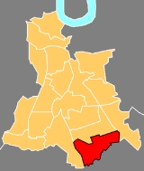
South East (London sub region)
The South East is a sub-region of the London Plan corresponding to the London Boroughs of Bexley, Bromley, Greenwich, Lewisham and Southwark. The sub region was established in 2008. The south east has a population of 1,300,000 and is the location of 500,000 jobs...
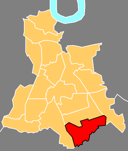
, occupying much of the boundary between the London Borough of Lewisham
London Borough of Lewisham
The London Borough of Lewisham is a London borough in south-east London, England and forms part of Inner London. The principal settlement of the borough is Lewisham...
and the London Borough of Bromley
London Borough of Bromley
The London Borough of Bromley is a London borough of south east London, England and forms part of Outer London. The principal town in the borough is Bromley.-Geography:...
; it is the name of an electoral ward
Wards of the United Kingdom
A ward in the United Kingdom is an electoral district at sub-national level represented by one or more councillors. It is the primary unit of British administrative and electoral geography .-England:...
covering much of the area on the Lewisham side. Downham was named in honour of Lord Downham, who was chairman of the London County Council between 1919-20.
The Prime Meridian
Prime Meridian
The Prime Meridian is the meridian at which the longitude is defined to be 0°.The Prime Meridian and its opposite the 180th meridian , which the International Date Line generally follows, form a great circle that divides the Earth into the Eastern and Western Hemispheres.An international...
passes just to the west of Downham.
Downham estate
The dominant feature of the area is the Downham EstateDownham Estate
The Downham Estate is a housing estate in Downham, south east London. It is mainly in the London Borough of Lewisham and partly in the London Borough of Bromley....
built by the London County Council
London County Council
London County Council was the principal local government body for the County of London, throughout its 1889–1965 existence, and the first London-wide general municipal authority to be directly elected. It covered the area today known as Inner London and was replaced by the Greater London Council...
during the late 1920s. The first tenants of the estate were mainly former residents of inner city areas, such as Rotherhithe
Rotherhithe
Rotherhithe is a residential district in inner southeast London, England and part of the London Borough of Southwark. It is located on a peninsula on the south bank of the Thames, facing Wapping and the Isle of Dogs on the north bank, and is a part of the Docklands area...
and the accommodation was spacious and luxurious compared to their former dwellings.
The Downham Estate provides an example of the programme of building council housing
Council house
A council house, otherwise known as a local authority house, is a form of public or social housing. The term is used primarily in the United Kingdom and the Republic of Ireland. Council houses were built and operated by local councils to supply uncrowded, well-built homes on secure tenancies at...
occurring in Britain
United Kingdom
The United Kingdom of Great Britain and Northern IrelandIn the United Kingdom and Dependencies, other languages have been officially recognised as legitimate autochthonous languages under the European Charter for Regional or Minority Languages...
between the first and second world wars. Among other similar developments around London (for example Becontree
Becontree
Becontree is a place in the London Borough of Barking and Dagenham, east north-east of Charing Cross.-Becontree estate:The area was developed between 1921 and 1932 by the London County Council as a large council estate of 27,000 homes, intended as "homes for heroes" after World War I. With a...
), it was developed to help alleviate the chronic shortage of housing in London, partly brought about by the complete cessation of building during WWI. It was intended to show what could be achieved by public-sector house-building: particularly in order to provide better housing for those who had lived in the slums of the city. The building of the Estate attracted subsidies from central government and was constructed under the auspices of the London County Council
London County Council
London County Council was the principal local government body for the County of London, throughout its 1889–1965 existence, and the first London-wide general municipal authority to be directly elected. It covered the area today known as Inner London and was replaced by the Greater London Council...
.
The estate covered an area of 522 acres (2.1 km²), of which 461 acres (1.9 km²) were in the Metropolitan Borough of Lewisham
Metropolitan Borough of Lewisham
The Metropolitan Borough of Lewisham was a Metropolitan borough in the County of London between 1900 and 1965, when it became part of the London Borough of Lewisham along with the Metropolitan Borough of Deptford.-History:...
, (from 1965 the London Borough of Lewisham
London Borough of Lewisham
The London Borough of Lewisham is a London borough in south-east London, England and forms part of Inner London. The principal settlement of the borough is Lewisham...
) and 61 acres (0.2 km²) in the Municipal Borough of Bromley
Municipal Borough of Bromley
Bromley was a local government district in northwest Kent from 1867 to 1965 around the town of Bromley. The area was suburban to London, and formed part of the Metropolitan Police District and from 1933 was included in the area of the London Passenger Transport Board.-Local board and urban...
(from 1965 the London Borough of Bromley
London Borough of Bromley
The London Borough of Bromley is a London borough of south east London, England and forms part of Outer London. The principal town in the borough is Bromley.-Geography:...
); altogether it covered a distance of 1.25 miles (2 km). The land had previously been mainly rural although around Grove Park railway station
Grove Park railway station
Grove Park railway station is a railway station in London, England. It is located on Baring Road within Travelcard Zone 4, and serves the areas of Grove Park and Downham in the London borough of Lewisham. The station was opened in 1871. Currently there are five platforms...
in the east of the area there had been some development; between Lewisham and Bromley was virtually the end of London at that time. 5659 houses were constructed of varying sizes; and there were also 408 flats (apartments) in blocks up to four storeys in height.
Currently there is a problem with Lewisham Council trying to destroy some of the heritage of this estate. They want to demolish Pendragon Special school only to rebuild it as a modern 2to 3 storey block. It will destroy these brick built buildings with solid parquet floors throughout which have been built at the same time as the family houses that surround it.
Education
Downham has two secondary schools, Bonus Pastor Catholic College and Haberdasher's Askes' Knights Academy (formerly Malory School until 2005).Primary Schools include Launcelot Primary School, Downderry Primary School, Merlin Primary School, Good Shepherd Primary School, Rangefield Primary School and Pendragon Special School for students aged 11years to 16 years.
Nearest places
- BellinghamBellingham- Places :Australia:* Bellingham, Tasmania, coastal hamlet in Northern TasmaniaEngland:* Bellingham, London, neighbourhood and electoral ward in the London Borough of Lewisham* Bellingham, Northumberland, villageUnited States:* Bellingham, Washington...
- CatfordCatfordCatford is a district in south London, England, located in the London Borough of Lewisham. It is situated south-east of Charing Cross. The area is identified in the London Plan as one of 35 major centres in Greater London.-Architecture:...
- ChinbrookChinbrookChinbrook is a suburb in southeast London; it is located southeast of Charing Cross and is in the southeast corner of the London Borough of Lewisham on its boundary with the London Borough of Bromley...
- Grove ParkGrove ParkGrove Park is an area, a suburb and electoral ward in the south-eastern corner of the London Borough of Lewisham and partly in the London Borough of Bromley. Early development grew up around Grove Park railway station in the 19th century, though there has been settlements located here since Celtic...
- BromleyBromleyBromley is a large suburban town in south east London, England and the administrative headquarters of the London Borough of Bromley. It was historically a market town, and prior to 1963 was in the county of Kent and formed the administrative centre of the Municipal Borough of Bromley...
- BeckenhamBeckenhamBeckenham is a town in the London Borough of Bromley, England. It is located 8.4 miles south east of Charing Cross and 1.75 miles west of Bromley town...
- MottinghamMottinghamMottingham is a district of south London, England; located at the convergence of the London Borough of Bromley, the London Borough of Lewisham and the London Borough of Greenwich...
Transport
Downham is close to CatfordCatford
Catford is a district in south London, England, located in the London Borough of Lewisham. It is situated south-east of Charing Cross. The area is identified in the London Plan as one of 35 major centres in Greater London.-Architecture:...
Bus Garage to the north, and Grove Park Bus Station to the east. The area is served by bus routes 124, 136, 181, 208, 284, 336, and night bus routes N36 and N47. National Rail
National Rail
National Rail is a title used by the Association of Train Operating Companies as a generic term to define the passenger rail services operated in Great Britain...
stations in the area include and with trains operated by Southeastern
Southeastern (train operating company)
London & South Eastern Railway Limited, trading as Southeastern is a train operating company in south-east England. On 1 April 2006 it became the franchisee for the new Integrated Kent Franchise , replacing the publicly owned South Eastern Trains on the former South East Franchise...
.
The main through-road (double carriageway for most parts) is the A21 Bromley Road, which if followed southbound would lead through Bromley
Bromley
Bromley is a large suburban town in south east London, England and the administrative headquarters of the London Borough of Bromley. It was historically a market town, and prior to 1963 was in the county of Kent and formed the administrative centre of the Municipal Borough of Bromley...
Town Centre down to Hastings
Hastings
Hastings is a town and borough in the county of East Sussex on the south coast of England. The town is located east of the county town of Lewes and south east of London, and has an estimated population of 86,900....
some 55 miles away on the East Sussex
East Sussex
East Sussex is a county in South East England. It is bordered by the counties of Kent, Surrey and West Sussex, and to the south by the English Channel.-History:...
Coast.