

Sutton, London
Encyclopedia
Sutton is a large suburban town in southwest London
, England, and the administrative headquarters of the London Borough of Sutton
. It is located 10.6 miles (17.1 km) south-southwest of Charing Cross
and is one of the major metropolitan centres identified in the London Plan
. The town was connected to central London by rail in 1847. As part of the suburban growth of London in the 20th century, Sutton significantly expanded and increased in population, becoming a municipal borough
with neighbouring Cheam
in 1934, and has formed part of Greater London
since 1965. It now forms a significant civic and retail district.
The placename Sutton is recorded in the 1086 Domesday Book
as Sudtone. It is formed from Old English 'sūth' and 'tūn', meaning 'the south farm'. It was probably in relation to Mitcham
and Morden
that it was considered southerly. The name was later applied to Sutton Common
and the Sutton New Town development in the 19th century, and to the London Borough of Sutton
created in 1965.
villa in Beddington
. The Roman road of Stane Street forms part of the northern boundary of the parish of Sutton. The course of Stane Street through the area is now followed by the modern roads Stonecot Hill and London Road, and designated A24
on road maps.
William The Conqueror's
Domesday Book
of 1086 assesses Sudtone:
The Domesday Book also states that the Abbot of Chertsey held the Manor. This remained so until 1538 when the Manor was sold to King Henry VIII
, along with the manors of Ebisham (Epsom), Coulsdon
, and Horley
. They were all then granted to Sir Nicholas Carew of Beddington in that same year. When Sir Nicholas was sentenced to death for treason, the King seized the manors, and they remained possessions of the Crown until King Edward VI
granted part of them to Thomas, Lord of D'Arcy of Cliché, but kept the Manors of Sutton, Ebisham and Coulsdon. Queen Mary
later restored the whole of these manors to Francis, only son of Sir Nicholas Carew. At a later date, and for unknown reasons, the Manor once more became possession of the Crown until King Charles II
granted it to the Duke of Portland in 1663, who sold it in 1669 to Sir Robert Long, who sold it that same year to Sir Richard Mason. The Manor has regularly changed hands since.
road from London
to Brighton
was constructed, intersecting with a turnpike road from Carshalton to Ewell which was constructed at the same time. The toll bars for Cheam Road and Brighton Road were originally located at right angles to each other by the Cock Hotel, an inn that sat on the south-east corner of the intersection of the turnpikes. The toll bar for Carshalton Road was where the police station is now, though the existence of this toll bar is disputed. All three of these toll bars moved further away from the intersection after a number of years to account for the growth in Sutton's size. The northmost toll bar was situated where Rosehill is now. The toll bars remained in effect until 1882.
Sutton railway station was opened on May 10, 1847. Likely due to the new, fast link to central London, Sutton's population more than doubled between 1851 and 1861. New housing to accommodate this growth was constructed in the Lind Road area, and called the "New Town". Today, a pub on the corner of Lind Road and Greyhound Road is named The New Town. Sutton Water Company was incorporated in 1863, and the provision of water mains finally allowed houses to be built outside of the area defined by the water-yielding Thanet Sands. The Lord of the Manor at the time, Mr Alcock, sold land that was previously unsuitable for residential buildings, making it available for new construction. Sutton's population more than doubled between 1861 and 1871.
During the Second World War, few places were bombed. However, the Commonwealth War Graves Commission
lists 187 civilian casualties for Sutton and Cheam. In 1959 a local resident George Alcock started a campaign to preserve a unique avenue of Copper Beech trees. This led the same year to the formation of the Sutton & Cheam Society of which he was secretary for many years. A plaque commemorating his life is situated on the corner of Christchurch Park with Brighton Road. In 1945 the Sutton and Cheam
constituency was constituted.
hundred of Surrey
. It came within the area of the Metropolitan Police District
in 1840. The parish authorities lost control of poor relief in 1834 when the parish was grouped into Epsom Poor Law Union
. This led to the parish forming part of the Epsom Rural Sanitary District
from 1875. The parish of Sutton adopted the Local Government Act 1858 in 1882 and a local board
was formed to govern the area, which was constituted a local government district. The Local Government Act 1894
reformed it as Sutton Urban District, governed by an urban district council. In 1928 the area of the urban district was expanded, by the addition of the parish of Cheam
. The urban district was renamed to Sutton and Cheam to reflect this. The urban district council successfully petitioned for a charter of incorporation and the town became a municipal borough
in 1934. Having only nominal existence within a municipal borough, the civil parishes were merged in 1949. The municipal borough was abolished in 1965 and its former area became part of the London Borough of Sutton in Greater London
.
in the east, to Epsom
in the west. To the south of this belt is chalk
of the North Downs, and to the north is clay
. The belt of Thanet sands allowed wells to provide clean water, whereas the clay to the north mostly offered surface water of unsuitable quality. This feature attracted settlements to the sand belt from a very early date. The most notable of these were Epsom, Ewell
, Cuddington
, Cheam, Sutton, Carshalton, Wallington, and Waddon
. Nearby settlements include Belmont
, Carshalton
, Cheam
, Banstead
, St. Helier, Wallington
and Worcester Park
.
The Aspects apartment block can be seen across Sutton. In Sutton town centre, there are three main churches which are the Sutton Baptist Church, Trinity Church and St. Nicholas Church, as well as a Salvation Army
in Benhill Avenue.
There are also two areas of green space in the town centre; one called Manor Park which is situated opposite the modern Police Station and the other simply called Sutton Green, located at the lower end of the high street relatively near Sutton Bus station. Sutton Library sits at the top of the town next to the Civic Offices, home of Sutton Council. There is a cinema opposite the St. Nicholas Centre, the two being connected by an above street level covered walkway. To the north of Sutton, there is the Benhill Estate.
, Epsom Coaches (Quality Line)
, Abellio London
and Metrobus
. Routes 80, 151, 154, 164, 213, 280, 407, 413, 420, 470, S1, S3, S4 and the X26 Express
to Heathrow Airport all stop in Sutton, as well as two school routes which are 613, operated by Transdev London
and 627 operated by Arriva London
. A list of all Sutton bus routes and their destinations are listed below.
Within the town of Sutton, there are three railway stations. Sutton station is the town's major station, where frequent trains to London Victoria and London Bridge
run, as well as services to Horsham
, Dorking
, Epsom Downs
, Wimbledon
, and Luton
. West Sutton
and Sutton Common
are both on the First Capital Connect
lines to Wimbledon.
Sutton also has a taxi rank, which can be picked up from outside the station. The taxis queue along Lower Mulgrave Road.
television programme have often been filmed in Sutton (including recently the Durand Close council estate in Carshalton, now in process of demolition), and nearby Merton
. Additionally, the Channel 4 TV show
The Games training is filmed at Sutton Arena. The town's football club, Sutton United F.C.
have also appeared regularly on adverts from energy drink manufacturers, Lucozade
.
The sitcom "Phoneshop
" which began in October 2010 and broadcast on E4 is filmed on Sutton High Street. It is based around a fictional phone shop which is located next to the South Entrance of Times Square Shopping Centre on the High Street. This shop was once a Sussex Stationers Bookshop which closed in 2009.
A TV commercial for the dating website "match.com
", which was first broadcast in August 2011 was filmed at Sutton Railway Station. The 60-second advert features an encounter between a young man and woman who are standing on opposite platforms while singing to each other.
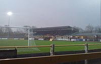 Association football club Sutton United F.C.
play in the Isthmian League Premier Division and famously beat 2-1 in the FA Cup
in 1989, who were then in Division 1 and winners of the contest two seasons previous.
Sutton Cricket Club is based in Cheam Road, Sutton, (entrance in Gander Green Lane.) The Club’s 1st XI plays at the highest level of the sport available to it, the England & Wales Cricket Board’s, ‘Surrey Championship Premier Division,’ (winners in 2009.) The club’s 2nd and 3rd teams also play at the highest level available to them, the, ‘Surrey Championship 2nd XI and 3rd XI Premier Divisions,’ (2nd XI also league winners in 2009.) Sutton Cricket Club also provide league cricket for 4th and 5th XIs on Saturdays and for three XI’s on Sundays, two of which are dedicated to youth development. The club has a colts section with over 150 participants, and owns a second ground in Holmwood Close, Cheam. A cricket week is held at the Cheam Road ground every season, in addition to the club playing at least one mid-week friendly fixture every week.
Sutton Pumas basketball club are based in the Westcroft Leisure Centre, Carshalton.
London
London is the capital city of :England and the :United Kingdom, the largest metropolitan area in the United Kingdom, and the largest urban zone in the European Union by most measures. Located on the River Thames, London has been a major settlement for two millennia, its history going back to its...
, England, and the administrative headquarters of the London Borough of Sutton
London Borough of Sutton
The London Borough of Sutton is a London borough in South London, England and forms part of Outer London. It covers an area of and is the 80th largest local authority in England by population. It is one of the southernmost boroughs of London...
. It is located 10.6 miles (17.1 km) south-southwest of Charing Cross
Charing Cross
Charing Cross denotes the junction of Strand, Whitehall and Cockspur Street, just south of Trafalgar Square in central London, England. It is named after the now demolished Eleanor cross that stood there, in what was once the hamlet of Charing. The site of the cross is now occupied by an equestrian...
and is one of the major metropolitan centres identified in the London Plan
London Plan
The London Plan is a planning document written by the Mayor of London, England in the United Kingdom and published by the Greater London Authority. The plan was first published in final form on 10 February 2004 and has since been amended. The current version was published in February 2008...
. The town was connected to central London by rail in 1847. As part of the suburban growth of London in the 20th century, Sutton significantly expanded and increased in population, becoming a municipal borough
Municipal Borough of Sutton and Cheam
Sutton and Cheam was a local government district in north east Surrey, England from 1882 to 1965.Sutton Local Government District was formed on 20 December 1882, when the parish of Sutton adopted the Local Government Act 1858...
with neighbouring Cheam
Cheam
Cheam is a large suburban village close to Sutton in the London Borough of Sutton, England, and is located close to the southern boundary between Greater London and Surrey. It is divided into two main areas: North Cheam and Cheam Village. North Cheam includes more retail shops and supermarkets,...
in 1934, and has formed part of Greater London
Greater London
Greater London is the top-level administrative division of England covering London. It was created in 1965 and spans the City of London, including Middle Temple and Inner Temple, and the 32 London boroughs. This territory is coterminate with the London Government Office Region and the London...
since 1965. It now forms a significant civic and retail district.
Toponymy
| 1881 | 10,334 |
|---|---|
| 1891 | 13,977 |
| 1901 | 17,223 |
| 1911 | 21,270 |
| 1921 | 21,063 |
| 1931 | 27,989 |
| Absorbed by Sutton and Cheam parish ► Municipal Borough of Sutton and Cheam Sutton and Cheam was a local government district in north east Surrey, England from 1882 to 1965.Sutton Local Government District was formed on 20 December 1882, when the parish of Sutton adopted the Local Government Act 1858... |
|
| source: UK census | |
The placename Sutton is recorded in the 1086 Domesday Book
Domesday Book
Domesday Book , now held at The National Archives, Kew, Richmond upon Thames in South West London, is the record of the great survey of much of England and parts of Wales completed in 1086...
as Sudtone. It is formed from Old English 'sūth' and 'tūn', meaning 'the south farm'. It was probably in relation to Mitcham
Mitcham
Mitcham is a district in the south west area of London, in the London Borough of Merton. A suburban area, Mitcham is located on the border of Inner London and Outer London. It is both residentially and financially developed, well served by Transport for London, and home to Mitcham Town Centre,...
and Morden
Morden
Morden is a district in the London Borough of Merton. It is located approximately South-southwest of central London between Merton Park , Mitcham , Sutton and Worcester Park .- Origin of name :...
that it was considered southerly. The name was later applied to Sutton Common
Sutton Common
Sutton Common is a common located in Sutton, London. It is served by Sutton Common railway station....
and the Sutton New Town development in the 19th century, and to the London Borough of Sutton
London Borough of Sutton
The London Borough of Sutton is a London borough in South London, England and forms part of Outer London. It covers an area of and is the 80th largest local authority in England by population. It is one of the southernmost boroughs of London...
created in 1965.
Pre 1700
Archaeological finds in the region date back over ten thousand years, but the first substantial evidence of habitation comes from the excavation of a RomanAncient Rome
Ancient Rome was a thriving civilization that grew on the Italian Peninsula as early as the 8th century BC. Located along the Mediterranean Sea and centered on the city of Rome, it expanded to one of the largest empires in the ancient world....
villa in Beddington
Beddington
Beddington is a settlement between the London Boroughs of Sutton and Croydon. The BedZED low energy housing scheme is located here. In Beddington was a static inverter plant of HVDC Kingsnorth....
. The Roman road of Stane Street forms part of the northern boundary of the parish of Sutton. The course of Stane Street through the area is now followed by the modern roads Stonecot Hill and London Road, and designated A24
A24 road (Great Britain)
The A24 is a major road in England. It runs south from Clapham in southwest London through Morden before entering Surrey and heading through Ewell, Epsom, Ashtead, Leatherhead and Dorking...
on road maps.
William The Conqueror's
William I of England
William I , also known as William the Conqueror , was the first Norman King of England from Christmas 1066 until his death. He was also Duke of Normandy from 3 July 1035 until his death, under the name William II...
Domesday Book
Domesday Book
Domesday Book , now held at The National Archives, Kew, Richmond upon Thames in South West London, is the record of the great survey of much of England and parts of Wales completed in 1086...
of 1086 assesses Sudtone:
In the time of King EdwardEdward the ConfessorEdward the Confessor also known as St. Edward the Confessor , son of Æthelred the Unready and Emma of Normandy, was one of the last Anglo-Saxon kings of England and is usually regarded as the last king of the House of Wessex, ruling from 1042 to 1066....
it was assessed at 30 hidesHide (unit)The hide was originally an amount of land sufficient to support a household, but later in Anglo-Saxon England became a unit used in assessing land for liability to "geld", or land tax. The geld would be collected at a stated rate per hide...
; now at 8½ hides. There are 2 carucateCarucateThe carucate or ploughland was a unit of assessment for tax used in most Danelaw counties of England, and is found for example in Domesday Book. The carucate was based on the area a plough team of eight oxen could till in a single annual season...
s in the demesneDemesneIn the feudal system the demesne was all the land, not necessarily all contiguous to the manor house, which was retained by a lord of the manor for his own use and support, under his own management, as distinguished from land sub-enfeoffed by him to others as sub-tenants...
, and 29 villains and 4 cottars with 13 carucates. There are 2 churches, and 2 bondmen, and 2 acres (8,093.7 m²) of meadow. The wood yields 10 swine. In the time of King Edward it was valued at 20 pounds, now at 15 pounds.
The Domesday Book also states that the Abbot of Chertsey held the Manor. This remained so until 1538 when the Manor was sold to King Henry VIII
Henry VIII of England
Henry VIII was King of England from 21 April 1509 until his death. He was Lord, and later King, of Ireland, as well as continuing the nominal claim by the English monarchs to the Kingdom of France...
, along with the manors of Ebisham (Epsom), Coulsdon
Coulsdon
Coulsdon is a town on the southernmost boundary of the London Borough of Croydon. It is surrounded by the Metropolitan Green Belt of the Farthing Down, Coulsdon Common and Kenley Common...
, and Horley
Horley
Horley is a town in Surrey, England, situated south of the twin towns of Reigate and Redhill, and north of Gatwick Airport and Crawley.With fast links by train to London from Horley railway station, it has grown popular with commuters in recent years...
. They were all then granted to Sir Nicholas Carew of Beddington in that same year. When Sir Nicholas was sentenced to death for treason, the King seized the manors, and they remained possessions of the Crown until King Edward VI
Edward VI of England
Edward VI was the King of England and Ireland from 28 January 1547 until his death. He was crowned on 20 February at the age of nine. The son of Henry VIII and Jane Seymour, Edward was the third monarch of the Tudor dynasty and England's first monarch who was raised as a Protestant...
granted part of them to Thomas, Lord of D'Arcy of Cliché, but kept the Manors of Sutton, Ebisham and Coulsdon. Queen Mary
Mary I of England
Mary I was queen regnant of England and Ireland from July 1553 until her death.She was the only surviving child born of the ill-fated marriage of Henry VIII and his first wife Catherine of Aragon. Her younger half-brother, Edward VI, succeeded Henry in 1547...
later restored the whole of these manors to Francis, only son of Sir Nicholas Carew. At a later date, and for unknown reasons, the Manor once more became possession of the Crown until King Charles II
Charles II of England
Charles II was monarch of the three kingdoms of England, Scotland, and Ireland.Charles II's father, King Charles I, was executed at Whitehall on 30 January 1649, at the climax of the English Civil War...
granted it to the Duke of Portland in 1663, who sold it in 1669 to Sir Robert Long, who sold it that same year to Sir Richard Mason. The Manor has regularly changed hands since.
Post 1700
In 1755, a turnpikeTurnpike trust
Turnpike trusts in the United Kingdom were bodies set up by individual Acts of Parliament, with powers to collect road tolls for maintaining the principal highways in Britain from the 17th but especially during the 18th and 19th centuries...
road from London
London
London is the capital city of :England and the :United Kingdom, the largest metropolitan area in the United Kingdom, and the largest urban zone in the European Union by most measures. Located on the River Thames, London has been a major settlement for two millennia, its history going back to its...
to Brighton
Brighton
Brighton is the major part of the city of Brighton and Hove in East Sussex, England on the south coast of Great Britain...
was constructed, intersecting with a turnpike road from Carshalton to Ewell which was constructed at the same time. The toll bars for Cheam Road and Brighton Road were originally located at right angles to each other by the Cock Hotel, an inn that sat on the south-east corner of the intersection of the turnpikes. The toll bar for Carshalton Road was where the police station is now, though the existence of this toll bar is disputed. All three of these toll bars moved further away from the intersection after a number of years to account for the growth in Sutton's size. The northmost toll bar was situated where Rosehill is now. The toll bars remained in effect until 1882.
Sutton railway station was opened on May 10, 1847. Likely due to the new, fast link to central London, Sutton's population more than doubled between 1851 and 1861. New housing to accommodate this growth was constructed in the Lind Road area, and called the "New Town". Today, a pub on the corner of Lind Road and Greyhound Road is named The New Town. Sutton Water Company was incorporated in 1863, and the provision of water mains finally allowed houses to be built outside of the area defined by the water-yielding Thanet Sands. The Lord of the Manor at the time, Mr Alcock, sold land that was previously unsuitable for residential buildings, making it available for new construction. Sutton's population more than doubled between 1861 and 1871.
During the Second World War, few places were bombed. However, the Commonwealth War Graves Commission
Commonwealth War Graves Commission
The Commonwealth War Graves Commission is an intergovernmental organisation of six independent member states whose principal function is to mark, record and maintain the graves, and places of commemoration, of Commonwealth of Nations military service members who died in the two World Wars...
lists 187 civilian casualties for Sutton and Cheam. In 1959 a local resident George Alcock started a campaign to preserve a unique avenue of Copper Beech trees. This led the same year to the formation of the Sutton & Cheam Society of which he was secretary for many years. A plaque commemorating his life is situated on the corner of Christchurch Park with Brighton Road. In 1945 the Sutton and Cheam
Sutton and Cheam (UK Parliament constituency)
Sutton and Cheam is a constituency represented in the House of Commons of the Parliament of the United Kingdom. It elects one Member of Parliament by the first past the post system of election. The current MP is Paul Burstow of the Liberal Democrats, first elected at the 1997 general election...
constituency was constituted.
Local government
Sutton formed an ancient parish in the WallingtonWallington (hundred)
Wallington was an ancient hundred in the north east of the county of Surrey, England. The majority of its area has been absorbed by the growth of London; with its name currently referring to the district of Wallington...
hundred of Surrey
Surrey
Surrey is a county in the South East of England and is one of the Home Counties. The county borders Greater London, Kent, East Sussex, West Sussex, Hampshire and Berkshire. The historic county town is Guildford. Surrey County Council sits at Kingston upon Thames, although this has been part of...
. It came within the area of the Metropolitan Police District
Metropolitan Police District
The Metropolitan Police District is the police area which is policed by London's Metropolitan Police Service. It currently consists of Greater London, excluding the City of London.-History:...
in 1840. The parish authorities lost control of poor relief in 1834 when the parish was grouped into Epsom Poor Law Union
Poor Law Union
A Poor Law Union was a unit used for local government in the United Kingdom from the 19th century. The administration of the Poor Law was the responsibility of parishes, which varied wildly in their size, populations, financial resources, rateable values and requirements...
. This led to the parish forming part of the Epsom Rural Sanitary District
Sanitary district
Sanitary districts were established in England and Wales in 1875 and in Ireland in 1878. The districts were of two types, based on existing structures:*Urban sanitary districts in towns with existing local government bodies...
from 1875. The parish of Sutton adopted the Local Government Act 1858 in 1882 and a local board
Local board of health
Local Boards or Local Boards of Health were local authorities in urban areas of England and Wales from 1848 to 1894. They were formed in response to cholera epidemics and were given powers to control sewers, clean the streets, regulate slaughterhouses and ensure the proper supply of water to their...
was formed to govern the area, which was constituted a local government district. The Local Government Act 1894
Local Government Act 1894
The Local Government Act 1894 was an Act of the Parliament of the United Kingdom that reformed local government in England and Wales outside the County of London. The Act followed the reforms carried out at county level under the Local Government Act 1888...
reformed it as Sutton Urban District, governed by an urban district council. In 1928 the area of the urban district was expanded, by the addition of the parish of Cheam
Cheam
Cheam is a large suburban village close to Sutton in the London Borough of Sutton, England, and is located close to the southern boundary between Greater London and Surrey. It is divided into two main areas: North Cheam and Cheam Village. North Cheam includes more retail shops and supermarkets,...
. The urban district was renamed to Sutton and Cheam to reflect this. The urban district council successfully petitioned for a charter of incorporation and the town became a municipal borough
Municipal borough
Municipal boroughs were a type of local government district which existed in England and Wales between 1835 and 1974, in Northern Ireland from 1840 to 1973 and in the Republic of Ireland from 1840 to 2002...
in 1934. Having only nominal existence within a municipal borough, the civil parishes were merged in 1949. The municipal borough was abolished in 1965 and its former area became part of the London Borough of Sutton in Greater London
Greater London
Greater London is the top-level administrative division of England covering London. It was created in 1965 and spans the City of London, including Middle Temple and Inner Temple, and the 32 London boroughs. This territory is coterminate with the London Government Office Region and the London...
.
Geography
Sutton is one of several towns located on a narrow bed of Thanet sands which extends from CroydonCroydon
Croydon is a town in South London, England, located within the London Borough of Croydon to which it gives its name. It is situated south of Charing Cross...
in the east, to Epsom
Epsom
Epsom is a town in the borough of Epsom and Ewell in Surrey, England. Small parts of Epsom are in the Borough of Reigate and Banstead. The town is located south-south-west of Charing Cross, within the Greater London Urban Area. The town lies on the chalk downland of Epsom Downs.-History:Epsom lies...
in the west. To the south of this belt is chalk
Chalk
Chalk is a soft, white, porous sedimentary rock, a form of limestone composed of the mineral calcite. Calcite is calcium carbonate or CaCO3. It forms under reasonably deep marine conditions from the gradual accumulation of minute calcite plates shed from micro-organisms called coccolithophores....
of the North Downs, and to the north is clay
Clay
Clay is a general term including many combinations of one or more clay minerals with traces of metal oxides and organic matter. Geologic clay deposits are mostly composed of phyllosilicate minerals containing variable amounts of water trapped in the mineral structure.- Formation :Clay minerals...
. The belt of Thanet sands allowed wells to provide clean water, whereas the clay to the north mostly offered surface water of unsuitable quality. This feature attracted settlements to the sand belt from a very early date. The most notable of these were Epsom, Ewell
Ewell
Ewell is a village in the borough of Epsom and Ewell in Surrey, close to the southern boundary of Greater London. It is located 14 miles south-south-west of Charing Cross and forms part of the suburbia that surrounds Greater London. Despite its growing population it is still referred to as a...
, Cuddington
Cuddington, Surrey
Cuddington was a village in Surrey which was demolished to make way for Henry VIII's Nonsuch Palace near Cheam. Cuddington lay within the Copthorne hundred, an administrative division devised by the Saxons...
, Cheam, Sutton, Carshalton, Wallington, and Waddon
Waddon
Waddon is a place in the London Borough of Croydon, to the south west of central Croydon on the borders of the London Borough of Sutton. Waddon has an older area with 19th century properties, some even older, close to central Croydon. Further south is a large estate of Council-owned homes and a...
. Nearby settlements include Belmont
Belmont, Sutton
Belmont is a village in the London Borough of Sutton in southwest Greater London, England. It is located off the A217 road and near to Banstead Downs in Surrey. It is a suburban development situated 10.8 miles south-southwest of Charing Cross....
, Carshalton
Carshalton
Carshalton is a suburban area of the London Borough of Sutton, England. It is located 10 miles south-southwest of Charing Cross, situated in the valley of the River Wandle, one of the sources of which is Carshalton Ponds in the centre of the village. The combined population of the five wards...
, Cheam
Cheam
Cheam is a large suburban village close to Sutton in the London Borough of Sutton, England, and is located close to the southern boundary between Greater London and Surrey. It is divided into two main areas: North Cheam and Cheam Village. North Cheam includes more retail shops and supermarkets,...
, Banstead
Banstead
Banstead is a town in the borough of Reigate and Banstead in the county of Surrey, England, on the border with Greater London. It lies south of London, west of Croydon and of the county town of Kingston-Upon-Thames. Banstead is on the North Downs and is protected by the Metropolitan Green Belt;...
, St. Helier, Wallington
Wallington, London
Wallington is a town in the London Borough of Sutton situated south south-west of Charing Cross. Prior to the merger of the Municipal Borough of Beddington and Wallington into the London Borough of Sutton, it was part of the county of Surrey.- History :...
and Worcester Park
Worcester Park
Worcester Park is a suburb of London, England covering both the extreme north west of the London Borough of Sutton in Greater London , part of the Borough of Epsom and Ewell in Surrey and The Royal Borough of Kingston upon Thames. The area is south west of Charing Cross...
.
The Aspects apartment block can be seen across Sutton. In Sutton town centre, there are three main churches which are the Sutton Baptist Church, Trinity Church and St. Nicholas Church, as well as a Salvation Army
Salvation Army
The Salvation Army is a Protestant Christian church known for its thrift stores and charity work. It is an international movement that currently works in over a hundred countries....
in Benhill Avenue.
There are also two areas of green space in the town centre; one called Manor Park which is situated opposite the modern Police Station and the other simply called Sutton Green, located at the lower end of the high street relatively near Sutton Bus station. Sutton Library sits at the top of the town next to the Civic Offices, home of Sutton Council. There is a cinema opposite the St. Nicholas Centre, the two being connected by an above street level covered walkway. To the north of Sutton, there is the Benhill Estate.
Economy
Sutton provides one of the many town centres in the London area. There are good public transport links through buses and trains, and a one-way system around the High Street as well as three car parks. Sutton has two shopping centres, both of which are in Sutton High Street. The largest of these is the St. Nicholas Centre with three main levels. Times Square is the smaller of the two shopping centres. Also Sutton High Street contains many well known stores. The High Street starts by Marshall's Road and extends to the station, in Grove Road. Supermarket stores Asda and Morrisons are located at either ends of the High Street. The area is pedestrianised during shopping hours. Sutton nightlife is both plentiful and vibrant and boasts a substantial number of pubs and clubs in and around the Sutton High Street area. The nightlife scene in Sutton has expanded rapidly since the late Nineties.Transport
Local bus services that stop at Sutton are operated by London GeneralLondon General
London General is a bus company operating in Surrey ang Greater London. It is owned by the Go-Ahead Group and operates most buses under contract to London Buses...
, Epsom Coaches (Quality Line)
Epsom Coaches
Epsom Coaches is a coach operator in the United Kingdom, based in the Surrey town of Epsom. The coach business was established in the 1920s and has prided itself on being one of the best coach operators in the UK. It operates a luxury fleet of mostly Setra coaches, and provides a number of tours...
, Abellio London
Abellio (UK bus company)
Abellio London and Abellio Surrey operate buses in London and Surrey. They are part of the Abellio Group owned by the Nederlandse Spoorwegen.-History:...
and Metrobus
Metrobus (Go-Ahead Group)
Metrobus is a bus operator with routes in south and south-east London, and parts of Surrey, Kent, West and East Sussex. The company operates many routes on tender from Transport for London. Formed through a management buyout of Tillingbourne Ltd...
. Routes 80, 151, 154, 164, 213, 280, 407, 413, 420, 470, S1, S3, S4 and the X26 Express
London Buses route X26
London Buses route X26 is a Transport for London contracted bus route from Heathrow Airport to West Croydon. The service is currently contracted to Metrobus.The route is the longest London Buses route in London.-History:...
to Heathrow Airport all stop in Sutton, as well as two school routes which are 613, operated by Transdev London
Transdev London
London United is one of many operators of London Buses and is owned by the RATP Group, an international public transport operator owned by the government of France...
and 627 operated by Arriva London
Arriva London
Arriva London is a division of Arriva which operates bus services in London, UK. It is made up of many previous bus operators including previously independent Grey Green...
. A list of all Sutton bus routes and their destinations are listed below.
- 80 (Belmont Prisons - Hackbridge Reynolds Close) - London General - Sutton Garage
- 151 (Worcester Park Station - Wallington Shotfield) - London General - Sutton Garage
- 154 (Morden Tube Station - West Croydon Bus Station) - London General - Sutton Garage
- 164 (Wimbledon Station - Sutton Station) - London General - Merton Garage
- 213 (Kingston Fairfield Road Bus Station - Sutton Bus Garage) - London General - Sutton Garage
- 280 (Tooting St. Georges Hospital - Belmont Station) - London General - Merton Garage
- 407 (Sutton Marshalls Road - Caterham Station) - Abellio London - Beddington Cross Garage
- 413 (Morden Tube Station - Sutton Bus Garage) - London General - Sutton Garage
- 420 (Sutton Bus Station - Redhill Bus Station) - Metrobus Surrey - Crawley Garage
- 470 (Epsom Town Centre - Colliers Wood Tube Station) - Quality Line - Epsom Garage
- 613 (Glenthorne School - Worcester Park Station) - Transdev London - Tolworth Garage
- 627 (Worcester Park Station - Wallington High School for Girls Arriva London - Croydon Garage
- S1 (Mitcham Cricketers - Banstead Marks & Spencer) - Quality Line - Epsom Garage
- S3 (Malden Manor Station - Sutton Hospital) - Quality Line - Epsom Garage
- S4 (St. Helier Station & Hospital - Roundshaw Neighbourhood Centre) - Quality Line - Epsom Garage
- X26 Express (Heathrow Airport Central Bus Station - West Croydon Lunar House) - Metrobus London - Croydon Garage
Within the town of Sutton, there are three railway stations. Sutton station is the town's major station, where frequent trains to London Victoria and London Bridge
London Bridge
London Bridge is a bridge over the River Thames, connecting the City of London and Southwark, in central London. Situated between Cannon Street Railway Bridge and Tower Bridge, it forms the western end of the Pool of London...
run, as well as services to Horsham
Horsham railway station
Horsham railway station serves the town of Horsham in West Sussex, England. It is on the Arun Valley Line 61 km south of London Victoria and the Sutton & Mole Valley Lines, and train services are provided by Southern...
, Dorking
Dorking railway station
Dorking railway station is one of three railway stations that serve the town of Dorking in Surrey, England. The station is within walking distance of Dorking Deepdene station and interchange on a through ticket is permitted...
, Epsom Downs
Epsom Downs railway station
Epsom Downs railway station is a railway station located on the boundary of the Reigate and Banstead and Epsom and Ewell boroughs of Surrey with the railway to the north forming a continuation of the boundary....
, Wimbledon
Wimbledon station
Wimbledon station is a National Rail, London Underground, and Tramlink station located in Wimbledon in the London Borough of Merton, and is the only London station that provides an interchange between rail, Underground, and Tramlink services...
, and Luton
Luton railway station
Luton railway station is located in Luton, Bedfordshire, England. The station is near to the town centre, about three minutes' walk from the Arndale Shopping Centre. It is situated on the Midland Main Line and is operated by First Capital Connect.-History:...
. West Sutton
West Sutton railway station
West Sutton railway station is in the London Borough of Sutton in South London. The station is served by First Capital Connect trains, and is on the Thameslink loop. It is in Travelcard Zone 5.-History:...
and Sutton Common
Sutton Common railway station
Sutton Common railway station is in the London Borough of Sutton in South London. The station is served by First Capital Connect trains, and is on the Thameslink loop. It is in Travelcard Zone 4.-History:...
are both on the First Capital Connect
First Capital Connect
First Capital Connect is a passenger train operating company in England that began operations on the National Rail network on 1 April 2006...
lines to Wimbledon.
Sutton also has a taxi rank, which can be picked up from outside the station. The taxis queue along Lower Mulgrave Road.
Media
The episode The Return of Mr Bean was filmed at department store Allders on its previous site, which is now occupied by Waterstones book shop and others. Furthermore, episodes of The BillThe Bill
The Bill is a police procedural television series that ran from October 1984 to August 2010. It focused on the lives and work of one shift of police officers, rather than on any particular aspect of police work...
television programme have often been filmed in Sutton (including recently the Durand Close council estate in Carshalton, now in process of demolition), and nearby Merton
London Borough of Merton
The London Borough of Merton is a borough in southwest London, England.The borough was formed under the London Government Act in 1965 by the merger of the Municipal Borough of Mitcham, the Municipal Borough of Wimbledon and the Merton and Morden Urban District, all formerly within Surrey...
. Additionally, the Channel 4 TV show
The Games training is filmed at Sutton Arena. The town's football club, Sutton United F.C.
Sutton United F.C.
Sutton United Football Club is an English football club currently playing in the Conference South. They are based in Sutton, London, and play their home games at the Borough Sports Ground in Gander Green Lane....
have also appeared regularly on adverts from energy drink manufacturers, Lucozade
Lucozade
Lucozade is an umbrella name for a 6 series of energy and sports drinks, produced by GlaxoSmithKline in Gloucestershire. The former company became part of Beecham and, after the mergers of SmithKline and Beecham in 2000, GlaxoSmithKline....
.
The sitcom "Phoneshop
PhoneShop
PhoneShop is a British sitcom first broadcast on Channel 4 as a television pilot on 13 November 2009, as part of the channel's Comedy Showcase season of comedy pilots. This was followed by a six-episode series on E4 that started on 7 October 2010...
" which began in October 2010 and broadcast on E4 is filmed on Sutton High Street. It is based around a fictional phone shop which is located next to the South Entrance of Times Square Shopping Centre on the High Street. This shop was once a Sussex Stationers Bookshop which closed in 2009.
A TV commercial for the dating website "match.com
Match.com
Match.com is an online dating company which reportedly has more than 20 million members, made up of a 49/51 male/female ratio, and Web sites serving 25 countries in more than 8 different languages. Its headquarters are in Dallas, Texas and the company also has offices in West Hollywood, Tokyo, Rio,...
", which was first broadcast in August 2011 was filmed at Sutton Railway Station. The 60-second advert features an encounter between a young man and woman who are standing on opposite platforms while singing to each other.
Sport
Sutton United F.C.
Sutton United Football Club is an English football club currently playing in the Conference South. They are based in Sutton, London, and play their home games at the Borough Sports Ground in Gander Green Lane....
play in the Isthmian League Premier Division and famously beat 2-1 in the FA Cup
FA Cup
The Football Association Challenge Cup, commonly known as the FA Cup, is a knockout cup competition in English football and is the oldest association football competition in the world. The "FA Cup" is run by and named after The Football Association and usually refers to the English men's...
in 1989, who were then in Division 1 and winners of the contest two seasons previous.
Sutton Cricket Club is based in Cheam Road, Sutton, (entrance in Gander Green Lane.) The Club’s 1st XI plays at the highest level of the sport available to it, the England & Wales Cricket Board’s, ‘Surrey Championship Premier Division,’ (winners in 2009.) The club’s 2nd and 3rd teams also play at the highest level available to them, the, ‘Surrey Championship 2nd XI and 3rd XI Premier Divisions,’ (2nd XI also league winners in 2009.) Sutton Cricket Club also provide league cricket for 4th and 5th XIs on Saturdays and for three XI’s on Sundays, two of which are dedicated to youth development. The club has a colts section with over 150 participants, and owns a second ground in Holmwood Close, Cheam. A cricket week is held at the Cheam Road ground every season, in addition to the club playing at least one mid-week friendly fixture every week.
Sutton Pumas basketball club are based in the Westcroft Leisure Centre, Carshalton.
External links
- Sutton, London - history and old photographs
- Sutton Town Centre Partnership working to improve Sutton.