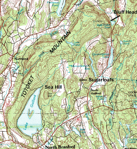
Pistapaug Mountain
Encyclopedia
Pistapaug Mountain, also known as Paug Mountain, est. 700 feet (213.4 m), is a traprock mountain located 11 miles (17.7 km) northeast of New Haven, Connecticut
. It is part of the narrow, linear Metacomet Ridge
that extends from Long Island Sound
near New Haven, Connecticut
, north through the Connecticut River Valley of Massachusetts
to the Vermont
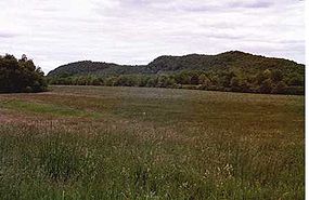
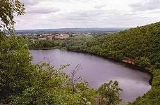
border. Pistapaug Mountain is known for its rugged topography and bluff overlooks, unique microclimate
ecosystems, and rare plant communities. It rises steeply 300 feet (91.4 m) above the Pistapaug Pond and the Quinnipiac River
valley to the west. The mountain is traversed by the 50 miles (80.5 km) Mattabesett Trail
.
, Pistapaug Mountain is 2 miles (3.2 km) long by 0.5 mile (0.80467 km) wide, although rugged topography makes the actual square mileage much larger. The Metacomet Ridge continues north from Pistapaug Mountain as Fowler Mountain
and south as Totoket Mountain
. Pistapaug Mountain is an important aquifer
; Pistapaug Pond, located at the foot of the mountain to the east, is a drinking water supply. The mountain is largely wooded but offers a few clifftop overlooks to the west over Pistapaug Pond and the Quinnipiac River Valley.
The western half of Pistapaug Mountain drains into the Farm River, thence to the East Haven River and Long Island Sound; the east side drains into Parmalee Brook, then into the Coginchaug River
, thence into the Connecticut River
and Long Island Sound.
, also called traprock, a volcanic rock. The mountain formed near the end of the Triassic Period with the rifting apart of the North America
n continent from Africa
and Eurasia
. Lava
welled up from the rift and solidified into sheets of strata hundreds of feet thick. Subsequent faulting and earthquake
activity tilted the strata, creating the cliffs and ridgeline of Pistapaug Mountain. Hot, dry upper slopes, cool, moist ravines, and mineral-rich ledges of basalt talus
produce a combination of microclimate
ecosystems on the mountain that support plant and animal species uncommon in greater Connecticut. Pistapaug Mountain is also an important raptor migration path. (See Metacomet Ridge
for more information on the geology and ecosystem of Pistapaug Mountain).
land. The Mattabesett Trail (maintained by the Connecticut Forest and Park Association
), which stretches from the northern end of Lamentation Mountain
, south to Totoket Mountain
and north again to the Connecticut River, traverses the ridgeline of Pistapaug Mountain. Activities enjoyed on Mattabesett Trail include hiking
, snowshoeing, picnicking, and other passive pursuits. Pistapaug Pond is not open to the public. The trailhead for Pistapaug Mountain and the Mattabesett Trail is located between Totoket Mountain and Pistapaug Mountain on Connecticut Route 17, 4 miles (6.4 km) east of Northford center and 3.3 miles (5.3 km) west of the junction of Connecticut Route 77
. Parking is available alongside Route 17.
The ecosystems and ridgeline of Pistapaug Mountain are most threatened by development. In 2000, Pistapaug Mountain was included in a study by the National Park Service
for the designation of a new National Scenic Trail
now tentatively called the New England National Scenic Trail
, which would include the Metacomet-Monadnock Trail
in Massachusetts and the Mattabesett Trail
and Metacomet Trail
trails in Connecticut.
The Middlesex Land Trust and the Wallingford Land Trust have been active in conserving the viewshed
of Pistapaug Mountain.
New Haven, Connecticut
New Haven is the second-largest city in Connecticut and the sixth-largest in New England. According to the 2010 Census, New Haven's population increased by 5.0% between 2000 and 2010, a rate higher than that of the State of Connecticut, and higher than that of the state's five largest cities, and...
. It is part of the narrow, linear Metacomet Ridge
Metacomet Ridge
The Metacomet Ridge, Metacomet Ridge Mountains, or Metacomet Range of southern New England, United States, is a narrow and steep fault-block mountain ridge known for its extensive cliff faces, scenic vistas, microclimate ecosystems, and communities of plants considered rare or endangered...
that extends from Long Island Sound
Long Island Sound
Long Island Sound is an estuary of the Atlantic Ocean, located in the United States between Connecticut to the north and Long Island, New York to the south. The mouth of the Connecticut River at Old Saybrook, Connecticut, empties into the sound. On its western end the sound is bounded by the Bronx...
near New Haven, Connecticut
New Haven, Connecticut
New Haven is the second-largest city in Connecticut and the sixth-largest in New England. According to the 2010 Census, New Haven's population increased by 5.0% between 2000 and 2010, a rate higher than that of the State of Connecticut, and higher than that of the state's five largest cities, and...
, north through the Connecticut River Valley of Massachusetts
Massachusetts
The Commonwealth of Massachusetts is a state in the New England region of the northeastern United States of America. It is bordered by Rhode Island and Connecticut to the south, New York to the west, and Vermont and New Hampshire to the north; at its east lies the Atlantic Ocean. As of the 2010...
to the Vermont
Vermont
Vermont is a state in the New England region of the northeastern United States of America. The state ranks 43rd in land area, , and 45th in total area. Its population according to the 2010 census, 630,337, is the second smallest in the country, larger only than Wyoming. It is the only New England...
border. Pistapaug Mountain is known for its rugged topography and bluff overlooks, unique microclimate
Microclimate
A microclimate is a local atmospheric zone where the climate differs from the surrounding area. The term may refer to areas as small as a few square feet or as large as many square miles...
ecosystems, and rare plant communities. It rises steeply 300 feet (91.4 m) above the Pistapaug Pond and the Quinnipiac River
Quinnipiac River
The Quinnipiac River is a river in the New England region of the United States, located entirely in the state of Connecticut.It rises in west central Connecticut from Dead Wood Swamp west of the city of New Britain...
valley to the west. The mountain is traversed by the 50 miles (80.5 km) Mattabesett Trail
Mattabesett Trail
The Mattabesett Trail is a long, hook-shaped Blue-Blazed hiking trail in central Connecticut and a part of the newly designated New England National Scenic Trail. One half of the trail follows the high traprock ridges of the Metacomet Ridge, from Totoket Mountain in Guilford, Connecticut to...
.
Geography
Located within the town of DurhamDurham, Connecticut
Durham is a town in Middlesex County, Connecticut, United States. Durham is a former farming village on the Coginchaug River in central Connecticut. The population was 6,627 at the 2000 census. Every autumn, the town hosts the Durham Fair, the largest volunteer agricultural fair in New...
, Pistapaug Mountain is 2 miles (3.2 km) long by 0.5 mile (0.80467 km) wide, although rugged topography makes the actual square mileage much larger. The Metacomet Ridge continues north from Pistapaug Mountain as Fowler Mountain
Fowler Mountain
Fowler Mountain, est. , is a traprock mountain located southeast of the center of Meriden, Connecticut. It is part of the narrow, linear Metacomet Ridge that extends from Long Island Sound near New Haven, Connecticut, north through the Connecticut River Valley of Massachusetts to the Vermont border...
and south as Totoket Mountain
Totoket Mountain
Totoket Mountain, with a high point of above sea level, is a traprock massif with several distinct summits, located northeast of New Haven, Connecticut. It is part of the Metacomet Ridge that extends from Long Island Sound near New Haven, north through the Connecticut River Valley of...
. Pistapaug Mountain is an important aquifer
Aquifer
An aquifer is a wet underground layer of water-bearing permeable rock or unconsolidated materials from which groundwater can be usefully extracted using a water well. The study of water flow in aquifers and the characterization of aquifers is called hydrogeology...
; Pistapaug Pond, located at the foot of the mountain to the east, is a drinking water supply. The mountain is largely wooded but offers a few clifftop overlooks to the west over Pistapaug Pond and the Quinnipiac River Valley.
The western half of Pistapaug Mountain drains into the Farm River, thence to the East Haven River and Long Island Sound; the east side drains into Parmalee Brook, then into the Coginchaug River
Coginchaug River
The Coginchaug River in Connecticut, with a watershed of including forests, pastures, farmland, industrial, and commercial areas, is the predominant tributary of the Mattabesset River...
, thence into the Connecticut River
Connecticut River
The Connecticut River is the largest and longest river in New England, and also an American Heritage River. It flows roughly south, starting from the Fourth Connecticut Lake in New Hampshire. After flowing through the remaining Connecticut Lakes and Lake Francis, it defines the border between the...
and Long Island Sound.
Geology and ecology
Pistapaug Mountain, like much of the Metacomet Ridge, is composed of basaltBasalt
Basalt is a common extrusive volcanic rock. It is usually grey to black and fine-grained due to rapid cooling of lava at the surface of a planet. It may be porphyritic containing larger crystals in a fine matrix, or vesicular, or frothy scoria. Unweathered basalt is black or grey...
, also called traprock, a volcanic rock. The mountain formed near the end of the Triassic Period with the rifting apart of the North America
North America
North America is a continent wholly within the Northern Hemisphere and almost wholly within the Western Hemisphere. It is also considered a northern subcontinent of the Americas...
n continent from Africa
Africa
Africa is the world's second largest and second most populous continent, after Asia. At about 30.2 million km² including adjacent islands, it covers 6% of the Earth's total surface area and 20.4% of the total land area...
and Eurasia
Eurasia
Eurasia is a continent or supercontinent comprising the traditional continents of Europe and Asia ; covering about 52,990,000 km2 or about 10.6% of the Earth's surface located primarily in the eastern and northern hemispheres...
. Lava
Lava
Lava refers both to molten rock expelled by a volcano during an eruption and the resulting rock after solidification and cooling. This molten rock is formed in the interior of some planets, including Earth, and some of their satellites. When first erupted from a volcanic vent, lava is a liquid at...
welled up from the rift and solidified into sheets of strata hundreds of feet thick. Subsequent faulting and earthquake
Earthquake
An earthquake is the result of a sudden release of energy in the Earth's crust that creates seismic waves. The seismicity, seismism or seismic activity of an area refers to the frequency, type and size of earthquakes experienced over a period of time...
activity tilted the strata, creating the cliffs and ridgeline of Pistapaug Mountain. Hot, dry upper slopes, cool, moist ravines, and mineral-rich ledges of basalt talus
Scree
Scree, also called talus, is a term given to an accumulation of broken rock fragments at the base of crags, mountain cliffs, or valley shoulders. Landforms associated with these materials are sometimes called scree slopes or talus piles...
produce a combination of microclimate
Microclimate
A microclimate is a local atmospheric zone where the climate differs from the surrounding area. The term may refer to areas as small as a few square feet or as large as many square miles...
ecosystems on the mountain that support plant and animal species uncommon in greater Connecticut. Pistapaug Mountain is also an important raptor migration path. (See Metacomet Ridge
Metacomet Ridge
The Metacomet Ridge, Metacomet Ridge Mountains, or Metacomet Range of southern New England, United States, is a narrow and steep fault-block mountain ridge known for its extensive cliff faces, scenic vistas, microclimate ecosystems, and communities of plants considered rare or endangered...
for more information on the geology and ecosystem of Pistapaug Mountain).
Recreation and conservation
Much of the east side of the mountain is private property; the west side is municipal watershedDrainage basin
A drainage basin is an extent or an area of land where surface water from rain and melting snow or ice converges to a single point, usually the exit of the basin, where the waters join another waterbody, such as a river, lake, reservoir, estuary, wetland, sea, or ocean...
land. The Mattabesett Trail (maintained by the Connecticut Forest and Park Association
Connecticut Forest and Park Association
The Connecticut Forest and Park Association , established in 1895, is the oldest private, nonprofit conservation organization in Connecticut. The organization is credited as an important early pioneer of the national land conservation movement and as an early advocate of long distance trail building...
), which stretches from the northern end of Lamentation Mountain
Lamentation Mountain
Lamentation Mountain, or Mount Lamentation, , is a traprock mountain located north of Meriden, Connecticut. It is part of the narrow, linear Metacomet Ridge that extends from Long Island Sound near New Haven, Connecticut, north through the Connecticut River Valley of Massachusetts to the Vermont...
, south to Totoket Mountain
Totoket Mountain
Totoket Mountain, with a high point of above sea level, is a traprock massif with several distinct summits, located northeast of New Haven, Connecticut. It is part of the Metacomet Ridge that extends from Long Island Sound near New Haven, north through the Connecticut River Valley of...
and north again to the Connecticut River, traverses the ridgeline of Pistapaug Mountain. Activities enjoyed on Mattabesett Trail include hiking
Hiking
Hiking is an outdoor activity which consists of walking in natural environments, often in mountainous or other scenic terrain. People often hike on hiking trails. It is such a popular activity that there are numerous hiking organizations worldwide. The health benefits of different types of hiking...
, snowshoeing, picnicking, and other passive pursuits. Pistapaug Pond is not open to the public. The trailhead for Pistapaug Mountain and the Mattabesett Trail is located between Totoket Mountain and Pistapaug Mountain on Connecticut Route 17, 4 miles (6.4 km) east of Northford center and 3.3 miles (5.3 km) west of the junction of Connecticut Route 77
Connecticut Route 77
Route 77 is a secondary state highway in southern Connecticut. It is a state-designated scenic road and runs from the Guilford town green, through North Guilford, into the town center of Durham.- Route description:...
. Parking is available alongside Route 17.
The ecosystems and ridgeline of Pistapaug Mountain are most threatened by development. In 2000, Pistapaug Mountain was included in a study by the National Park Service
National Park Service
The National Park Service is the U.S. federal agency that manages all national parks, many national monuments, and other conservation and historical properties with various title designations...
for the designation of a new National Scenic Trail
National Scenic Trail
National Scenic Trail is a designation for protected areas in the United States that consist of trails of particular natural beauty.National Scenic Trails were authorized under the National Trails System Act of 1968 along with National Historic Trails and National Recreation Trails...
now tentatively called the New England National Scenic Trail
New England National Scenic Trail
The New England National Scenic Trail is a National Scenic Trail in southern New England, which includes most of the three single trails Metacomet-Monadnock Trail, Mattabesett Trail and Metacomet Trail. After the Metacomet-Monadnock-Mattabesett trail system, the trail is sometimes called Triple-M...
, which would include the Metacomet-Monadnock Trail
Metacomet-Monadnock Trail
The Metacomet-Monadnock Trail is a hiking trail that traverses the Metacomet Ridge of the Pioneer Valley region of Massachusetts and the central uplands of Massachusetts and southern New Hampshire...
in Massachusetts and the Mattabesett Trail
Mattabesett Trail
The Mattabesett Trail is a long, hook-shaped Blue-Blazed hiking trail in central Connecticut and a part of the newly designated New England National Scenic Trail. One half of the trail follows the high traprock ridges of the Metacomet Ridge, from Totoket Mountain in Guilford, Connecticut to...
and Metacomet Trail
Metacomet Trail
The Metacomet Trail is a Blue-Blazed hiking trail that traverses the Metacomet Ridge of central Connecticut and is a part of the newly designated New England National Scenic Trail. Despite being easily accessible and close to large population centers, the trail is considered remarkably rugged and...
trails in Connecticut.
The Middlesex Land Trust and the Wallingford Land Trust have been active in conserving the viewshed
Viewshed
A viewshed is an area of land, water, or other environmental element that is visible to the human eye from a fixed vantage point. The term is used widely in such areas as urban planning, archaeology, and military science...
of Pistapaug Mountain.
See also
- Metacomet RidgeMetacomet RidgeThe Metacomet Ridge, Metacomet Ridge Mountains, or Metacomet Range of southern New England, United States, is a narrow and steep fault-block mountain ridge known for its extensive cliff faces, scenic vistas, microclimate ecosystems, and communities of plants considered rare or endangered...
- Adjacent summits:
↓ South North ↑