West Suffield Mountain
Encyclopedia
West Suffield Mountain, est. 710 feet (216.4 m), is a traprock mountain ridge located between the Berkshires and the Connecticut River Valley in north-central Connecticut
. It is part of the narrow, linear Metacomet Ridge
that extends from Long Island Sound
near New Haven, Connecticut
, north through the Connecticut River Valley of Massachusetts
to the Vermont
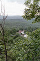
border. West Suffield Mountain is known for its scenic ledges and woodlands, unique microclimate
ecosystems, and rare plant communities. It is traversed by the 51 miles (82.1 km) Metacomet Trail
, and the 110 miles (177 km) Metacomet-Monadnock Trail
begins at the northern foot of West Suffield Mountain.
The West Suffield Mountain ridgeline extends south from the Connecticut
border in the hamlet of Rising Corner to the pass between it and Peak Mountain
on the Suffield
/East Granby
border. It lies entirely within the town of Suffield. The Metacomet Ridge, of which West Suffield Mountain is part, continues north as Provin Mountain
and south as Peak Mountain
. The northwest side of West Suffield Mountain drains into Congamond Lake, thence to the Westfield River
, then to the Connecticut River and Long Island Sound; the south and west sides drain into Salmon Brook, then to the Farmington River
, then to the Connecticut River. The east side drains into the Connecticut River.
, also called traprock, a volcanic rock. The mountain formed near the end of the Triassic Period with the rifting apart of the North America
n continent from Africa
and Eurasia
. Lava
welled up from the rift and solidified into sheets of strata hundreds of feet thick. Subsequent faulting and earthquake
activity tilted the strata, creating the cliffs and ridgeline of West Suffield Mountain. Hot, dry upper slopes, cool, moist ravines, and mineral-rich ledges of basalt talus
produce a combination of microclimate
ecosystems on the mountain that support plant and animal species uncommon in greater Connecticut. West Suffield Mountain is also an important raptor migration path. (See Metacomet Ridge
for more information on the geology and ecosystem of West Suffield Mountain).
 The 51 miles (82.1 km) Metacomet Trail
(maintained by the Connecticut Forest and Park Association), traverses West Suffield Mountain and is open to hiking
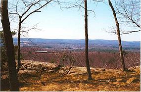
, snowshoeing, picnicking, and other passive pursuits; high ledges and overlooks provide scenic views of the surrounding rural countryside.
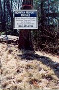
Expanding suburban sprawl and ridgetop homebuilding present the greatest threats to the unique ecosystem and landscape of West Suffield Mountain. Although much of the mountain lies within private ownership, recent conservation efforts by the town of Suffield, the Suffield Land Conservancy, and other non-profit groups have managed to preserve several key parcels on the mountain. In 2000, West Suffield Mountain was included in a study by the National Park Service
for the designation of a new National Scenic Trail
now tentatively called the New England National Scenic Trail
, which would include the Metacomet-Monadnock Trail
in Massachusetts and the Mattabesett Trail
and Metacomet Trail
trails in Connecticut.
Connecticut
Connecticut is a state in the New England region of the northeastern United States. It is bordered by Rhode Island to the east, Massachusetts to the north, and the state of New York to the west and the south .Connecticut is named for the Connecticut River, the major U.S. river that approximately...
. It is part of the narrow, linear Metacomet Ridge
Metacomet Ridge
The Metacomet Ridge, Metacomet Ridge Mountains, or Metacomet Range of southern New England, United States, is a narrow and steep fault-block mountain ridge known for its extensive cliff faces, scenic vistas, microclimate ecosystems, and communities of plants considered rare or endangered...
that extends from Long Island Sound
Long Island Sound
Long Island Sound is an estuary of the Atlantic Ocean, located in the United States between Connecticut to the north and Long Island, New York to the south. The mouth of the Connecticut River at Old Saybrook, Connecticut, empties into the sound. On its western end the sound is bounded by the Bronx...
near New Haven, Connecticut
New Haven, Connecticut
New Haven is the second-largest city in Connecticut and the sixth-largest in New England. According to the 2010 Census, New Haven's population increased by 5.0% between 2000 and 2010, a rate higher than that of the State of Connecticut, and higher than that of the state's five largest cities, and...
, north through the Connecticut River Valley of Massachusetts
Massachusetts
The Commonwealth of Massachusetts is a state in the New England region of the northeastern United States of America. It is bordered by Rhode Island and Connecticut to the south, New York to the west, and Vermont and New Hampshire to the north; at its east lies the Atlantic Ocean. As of the 2010...
to the Vermont
Vermont
Vermont is a state in the New England region of the northeastern United States of America. The state ranks 43rd in land area, , and 45th in total area. Its population according to the 2010 census, 630,337, is the second smallest in the country, larger only than Wyoming. It is the only New England...
border. West Suffield Mountain is known for its scenic ledges and woodlands, unique microclimate
Microclimate
A microclimate is a local atmospheric zone where the climate differs from the surrounding area. The term may refer to areas as small as a few square feet or as large as many square miles...
ecosystems, and rare plant communities. It is traversed by the 51 miles (82.1 km) Metacomet Trail
Metacomet Trail
The Metacomet Trail is a Blue-Blazed hiking trail that traverses the Metacomet Ridge of central Connecticut and is a part of the newly designated New England National Scenic Trail. Despite being easily accessible and close to large population centers, the trail is considered remarkably rugged and...
, and the 110 miles (177 km) Metacomet-Monadnock Trail
Metacomet-Monadnock Trail
The Metacomet-Monadnock Trail is a hiking trail that traverses the Metacomet Ridge of the Pioneer Valley region of Massachusetts and the central uplands of Massachusetts and southern New Hampshire...
begins at the northern foot of West Suffield Mountain.
Geography
The West Suffield Mountain ridgeline rises steeply between 250 and 550 ft (76.2 and 167.6 ) above the Connecticut River Valley to the east, with a high point of 710 feet (216.4 m) above sea level. A prominent landscape feature, it is roughly 4 miles (6 km) long by 1 mile (1½ km) wide at its widest point, although the steepness of the terrain makes the actual square mileage much larger.The West Suffield Mountain ridgeline extends south from the Connecticut
Connecticut
Connecticut is a state in the New England region of the northeastern United States. It is bordered by Rhode Island to the east, Massachusetts to the north, and the state of New York to the west and the south .Connecticut is named for the Connecticut River, the major U.S. river that approximately...
border in the hamlet of Rising Corner to the pass between it and Peak Mountain
Peak Mountain
Peak Mountain, also called Copper Mountain, est. , is a traprock mountain located in East Granby, Connecticut, south of the Massachusetts border and 6 miles west of the Connecticut River...
on the Suffield
Suffield, Connecticut
Suffield is a town in Hartford County, Connecticut, United States. It had once been within the boundaries of Massachusetts. The town is located in the Connecticut River Valley with the town of Enfield neighboring to the east. In 1900, 3,521 people lived in Suffield; and in 1910, 3,841. As of the...
/East Granby
East Granby, Connecticut
East Granby is a town in Hartford County, Connecticut, United States. The population was estimated at 5,058 in 2005. The town recently celebrated its 150th anniversary with a three-day festival on June 7, 8, and 9, 2008.-Geography:...
border. It lies entirely within the town of Suffield. The Metacomet Ridge, of which West Suffield Mountain is part, continues north as Provin Mountain
Provin Mountain
Provin Mountain is a very narrow traprock mountain ridge located in the Connecticut River Valley of Massachusetts. It is part of the Metacomet Ridge which extends from Long Island Sound near New Haven, Connecticut, north through the Connecticut River Valley of Massachusetts to the Vermont border...
and south as Peak Mountain
Peak Mountain
Peak Mountain, also called Copper Mountain, est. , is a traprock mountain located in East Granby, Connecticut, south of the Massachusetts border and 6 miles west of the Connecticut River...
. The northwest side of West Suffield Mountain drains into Congamond Lake, thence to the Westfield River
Westfield River
The Westfield River in Metropolitan Springfield, Massachusetts, is a major tributary of the Connecticut River in Hampden County, Massachusetts. The Westfield River has four major tributary branches that confluence in the City of Westfield, for which the river is named...
, then to the Connecticut River and Long Island Sound; the south and west sides drain into Salmon Brook, then to the Farmington River
Farmington River
The Farmington River is a river located in northwest Connecticut, with major tributaries extending into southwest Massachusetts. Via its longest branch , the Farmington's length increases to , making it the Connecticut River's longest tributary by a mere over the major river directly to its...
, then to the Connecticut River. The east side drains into the Connecticut River.
Geology and ecology
West Suffield Mountain, like much of the Metacomet Ridge, is composed of basaltBasalt
Basalt is a common extrusive volcanic rock. It is usually grey to black and fine-grained due to rapid cooling of lava at the surface of a planet. It may be porphyritic containing larger crystals in a fine matrix, or vesicular, or frothy scoria. Unweathered basalt is black or grey...
, also called traprock, a volcanic rock. The mountain formed near the end of the Triassic Period with the rifting apart of the North America
North America
North America is a continent wholly within the Northern Hemisphere and almost wholly within the Western Hemisphere. It is also considered a northern subcontinent of the Americas...
n continent from Africa
Africa
Africa is the world's second largest and second most populous continent, after Asia. At about 30.2 million km² including adjacent islands, it covers 6% of the Earth's total surface area and 20.4% of the total land area...
and Eurasia
Eurasia
Eurasia is a continent or supercontinent comprising the traditional continents of Europe and Asia ; covering about 52,990,000 km2 or about 10.6% of the Earth's surface located primarily in the eastern and northern hemispheres...
. Lava
Lava
Lava refers both to molten rock expelled by a volcano during an eruption and the resulting rock after solidification and cooling. This molten rock is formed in the interior of some planets, including Earth, and some of their satellites. When first erupted from a volcanic vent, lava is a liquid at...
welled up from the rift and solidified into sheets of strata hundreds of feet thick. Subsequent faulting and earthquake
Earthquake
An earthquake is the result of a sudden release of energy in the Earth's crust that creates seismic waves. The seismicity, seismism or seismic activity of an area refers to the frequency, type and size of earthquakes experienced over a period of time...
activity tilted the strata, creating the cliffs and ridgeline of West Suffield Mountain. Hot, dry upper slopes, cool, moist ravines, and mineral-rich ledges of basalt talus
Scree
Scree, also called talus, is a term given to an accumulation of broken rock fragments at the base of crags, mountain cliffs, or valley shoulders. Landforms associated with these materials are sometimes called scree slopes or talus piles...
produce a combination of microclimate
Microclimate
A microclimate is a local atmospheric zone where the climate differs from the surrounding area. The term may refer to areas as small as a few square feet or as large as many square miles...
ecosystems on the mountain that support plant and animal species uncommon in greater Connecticut. West Suffield Mountain is also an important raptor migration path. (See Metacomet Ridge
Metacomet Ridge
The Metacomet Ridge, Metacomet Ridge Mountains, or Metacomet Range of southern New England, United States, is a narrow and steep fault-block mountain ridge known for its extensive cliff faces, scenic vistas, microclimate ecosystems, and communities of plants considered rare or endangered...
for more information on the geology and ecosystem of West Suffield Mountain).
Conservation and recreation
Metacomet Trail
The Metacomet Trail is a Blue-Blazed hiking trail that traverses the Metacomet Ridge of central Connecticut and is a part of the newly designated New England National Scenic Trail. Despite being easily accessible and close to large population centers, the trail is considered remarkably rugged and...
(maintained by the Connecticut Forest and Park Association), traverses West Suffield Mountain and is open to hiking
Hiking
Hiking is an outdoor activity which consists of walking in natural environments, often in mountainous or other scenic terrain. People often hike on hiking trails. It is such a popular activity that there are numerous hiking organizations worldwide. The health benefits of different types of hiking...
, snowshoeing, picnicking, and other passive pursuits; high ledges and overlooks provide scenic views of the surrounding rural countryside.
Expanding suburban sprawl and ridgetop homebuilding present the greatest threats to the unique ecosystem and landscape of West Suffield Mountain. Although much of the mountain lies within private ownership, recent conservation efforts by the town of Suffield, the Suffield Land Conservancy, and other non-profit groups have managed to preserve several key parcels on the mountain. In 2000, West Suffield Mountain was included in a study by the National Park Service
National Park Service
The National Park Service is the U.S. federal agency that manages all national parks, many national monuments, and other conservation and historical properties with various title designations...
for the designation of a new National Scenic Trail
National Scenic Trail
National Scenic Trail is a designation for protected areas in the United States that consist of trails of particular natural beauty.National Scenic Trails were authorized under the National Trails System Act of 1968 along with National Historic Trails and National Recreation Trails...
now tentatively called the New England National Scenic Trail
New England National Scenic Trail
The New England National Scenic Trail is a National Scenic Trail in southern New England, which includes most of the three single trails Metacomet-Monadnock Trail, Mattabesett Trail and Metacomet Trail. After the Metacomet-Monadnock-Mattabesett trail system, the trail is sometimes called Triple-M...
, which would include the Metacomet-Monadnock Trail
Metacomet-Monadnock Trail
The Metacomet-Monadnock Trail is a hiking trail that traverses the Metacomet Ridge of the Pioneer Valley region of Massachusetts and the central uplands of Massachusetts and southern New Hampshire...
in Massachusetts and the Mattabesett Trail
Mattabesett Trail
The Mattabesett Trail is a long, hook-shaped Blue-Blazed hiking trail in central Connecticut and a part of the newly designated New England National Scenic Trail. One half of the trail follows the high traprock ridges of the Metacomet Ridge, from Totoket Mountain in Guilford, Connecticut to...
and Metacomet Trail
Metacomet Trail
The Metacomet Trail is a Blue-Blazed hiking trail that traverses the Metacomet Ridge of central Connecticut and is a part of the newly designated New England National Scenic Trail. Despite being easily accessible and close to large population centers, the trail is considered remarkably rugged and...
trails in Connecticut.
See also
- Metacomet RidgeMetacomet RidgeThe Metacomet Ridge, Metacomet Ridge Mountains, or Metacomet Range of southern New England, United States, is a narrow and steep fault-block mountain ridge known for its extensive cliff faces, scenic vistas, microclimate ecosystems, and communities of plants considered rare or endangered...
- Adjacent summits:
↓ South North ↑