
Sunderland, Massachusetts
Encyclopedia
Sunderland is a town
in Franklin County
, Massachusetts
, part of the Pioneer Valley
. The population was 3,777 as of the 2000 census. It is part of the Springfield, Massachusetts
Metropolitan Statistical Area
.
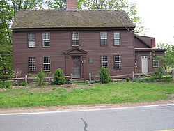
Sunderland was first settled in 1713 and was officially incorporated in 1718. It was first known as Swampfield, a name which is now honored by Swampfield Road, but the name was changed to attract more residents. It was renamed in honor of Charles Spencer
, the Earl of Sunderland
. Historically, the land was largely used for farming. Before the incorporation of Leverett
in 1774, that town was a part of Sunderland's territory.
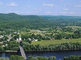
, the town has a total area of 14.8 square miles (38.3 km²), of which 14.4 square miles (37.3 km²) are land and 0.4 square miles (1 km²) (2.77%) is water. Sunderland is located in the Pioneer Valley
on the east bank of the Connecticut River
, which drains the town. Mount Toby
, a prominent conglomerate
mountain with a firetower lookout, stands at the east border of the town and is traversed by the 47-mile Robert Frost Trail
. The mountain, surrounded by Mount Toby State Forest, is known for its waterfalls, scenic vista, and biologically diverse ecosystem. Sunderland is home to the Buttonball Tree
, an American sycamore
famous for its size and age.
Sunderland lies on the southern edge of Franklin County, north of Hampshire County
. Sunderland is bordered by Montague
to the north, Leverett
to the east, Amherst
and Hadley
to the south, and Whately
and Deerfield
to the west. (Because of the river, there is no direct access between Sunderland and Whately.) From its town center just east of the Connecticut River, Sunderland is 10 miles (16.1 km) south of the county seat of Greenfield
, 28 miles (45.1 km) north of Springfield
, and 90 miles (144.8 km) west of Boston
. Most of the town's population lies in the western part of town, along the river, though there is a small village north of Mount Toby.
There is no interstate within town, with the nearest being Interstate 91
to the west of the town. Route 116
passes through the town, coming from Amherst and passing into Deerfield along the Sunderland Bridge
. The bridge is the only road crossing of the Connecticut River between the General Pierce Bridge
between Greenfield and Montague to the north, and the Calvin Coolidge Bridge
between Hadley and Northampton
to the south, a distance of 19 miles (30.6 km). Route 47
also passes through the western part of town, crossing Route 116 and heading north before terminating at Route 63 in Montague. Route 63 also passes through the town for a short distance in the northeast corner of town. It is along the side of Route 63 that the New England Central Railroad
passes through the town, carrying the Amtrak
Vermonter
line through town towards Vermont. There is, however, no stop for the train within the town. The town is served by a route of the Franklin Regional Transit Authority (FRTA) bus line, between Amherst and Greenfield, and a route of the Pioneer Valley Transit Authority (PVTA) bus line, between Amherst and South Deerfield. The nearest general aviation airport is the Turners Falls Airport
in Montague, with the nearest national air service being at Bradley International Airport
in Connecticut.
As of the census
of 2000, there were 3,777 people, 1,633 households, and 765 families residing in the town. The population density
was 262.5 people per square mile (101.3/km²). There were 1,668 housing units at an average density of 115.9 per square mile (44.8/km²). There were 1,633 households out of which 22.5% had children under the age of 18 living with them, 37.5% were married couples
living together, 6.7% had a female householder with no husband present, and 53.1% were non-families. 27.9% of all households were made up of individuals and 4.9% had someone living alone who was 65 years of age or older. The average household size was 2.28 and the average family size was 2.93.
The median income for a household in the town was $37,147, and the median income for a family was $53,021. Males had a median income of $36,779 versus $30,526 for females. The per capita income
for the town was $20,024. About 4.2% of families and 14.0% of the population were below the poverty line, including 5.8% of those under age 18 and none of those age 65 or over.
because towns are not allowed to raise taxes by more than 2.5% percent a year without voter approval. The town requested more money for education to ameliorate cuts in state funding because of the recession. In 2009 the town adopted a 0.75% sales tax on meals and hotels bringing the total including the state sales tax to 7%.
and Union 38 School District
s, which also includes Conway
, Whately
and Deerfield
. Each town operates its own elementary school, with Sunderland Elementary School serving the town's students from Preschool through sixth grades. All four towns send seventh through twelfth grade students to Frontier Regional School
in the town of Deerfield. Frontier's athletics teams are nicknamed the Redhawks, and the team colors are red and blue. There are many art programs available during and after school at Frontier. There are several private schools in the area, including The Bement School (a coeducational boarding school serving students from kindergarten through ninth grades), the Eaglebrook School (a private boys' school for grades 6-9), and the Deerfield Academy
, a private prep school.
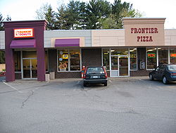 There are two 7-Eleven's
, a Dunkin' Donuts
, a Subway
, a hairdresser, a self service laundry, a Greenfield Cooperative Bank, a doggy daycare and a few convenience stores in Sunderland. The upscale Blue Heron Restaurant in Sunderland is located at the site of the old town hall, and Cooks Source Magazine
is also based in Sunderland.
 The town makes use of an Agricultural Preservation Restriction Program. The development rights to farmland are bought up for 80% of the assessed value of the land. This allows farming to continue on the land but prevents residential and commercial development of the land. Such actions though, have resulted in negative economic consequences and this is something that economists are becoming increasingly concerned about. According to the Office of Federal Housing Enterprise Oversight
, between 1980 and 2003, the nation’s largest overall percentage increase in housing prices occurred in Massachusetts. The cost of rental housing has grown similarly. A recent study by the National Low Income Housing Coalition rated Massachusetts as being the least affordable state in which to rent an apartment in 2003.
The town, however, has a significant number of rental housing units that are home to many students from the neighboring colleges. These rental units are affordable to low and moderate income residents, but are not qualified as "affordable" under Chapter 40B; the state's stringent affordable housing law which requires deed restrictions to assure affordability in perpetuity. Sunderland has more rental units per capita than nearly every other municipality in the Commonwealth of Massachusetts, and the market rates of these units are lower than the vast majority of unit rates proposed in the proposed Sugarbush Meadows rental complex.
developer Scott Nielsen. It would permanently designate 25 percent of its units for low-income or subsidized housing. He proposes to build the apartment complex off Plumtree Road. The project is a 40B project, a state category covering low-income housing that encourages the building of "affordable" housing to help ameliorate Massachusetts' high cost of homes. The plan has been heavily resisted by the town after a series of very tense public meetings of the town's zoning board.
In November 2009 an appeals hearing was held concerning the Sunderland Zoning Board of Appeal's rejection of the building application. The Housing Appeals Committee on June 21, 2010 overturned the decision and directed the zoning board to issue a comprehensive permit. It justified its decision by saying "One indication of the housing need in this case, however, is that only 0.4 % of the total housing in Sunderland is low and moderate income housing." This percentage reflects only the units with long-term deed restrictions under Chapter 40B, and discounts the reality that 51% of Sunderland's existing overall housing stock is affordable rental units.
Hockey and Football events, adult and youth sports, an annual Easter Egg Hunt, hikes, dance lessons, and many other activities in Sunderland and the surrounding areas. The town holds annual Fall Festivals in mid-October and a Memorial Day Parade and Ceremony.
New England town
The New England town is the basic unit of local government in each of the six New England states. Without a direct counterpart in most other U.S. states, New England towns are conceptually similar to civil townships in other states, but are incorporated, possessing powers like cities in other...
in Franklin County
Franklin County, Massachusetts
-Demographics:As of the census of 2000, there were 71,535 people, 29,466 households, and 18,416 families residing in the county. The population density was 102 people per square mile . There were 31,939 housing units at an average density of 46 per square mile...
, Massachusetts
Massachusetts
The Commonwealth of Massachusetts is a state in the New England region of the northeastern United States of America. It is bordered by Rhode Island and Connecticut to the south, New York to the west, and Vermont and New Hampshire to the north; at its east lies the Atlantic Ocean. As of the 2010...
, part of the Pioneer Valley
Pioneer Valley
The Pioneer Valley is the colloquial name for the U.S. Commonwealth of Massachusetts's portion of the Connecticut River Valley. The Pioneer Valley consists of three counties in Massachusetts which collectively feature much of New England's most fertile farmland...
. The population was 3,777 as of the 2000 census. It is part of the Springfield, Massachusetts
Springfield, Massachusetts
Springfield is the most populous city in Western New England, and the seat of Hampden County, Massachusetts, United States. Springfield sits on the eastern bank of the Connecticut River near its confluence with three rivers; the western Westfield River, the eastern Chicopee River, and the eastern...
Metropolitan Statistical Area
Springfield, Massachusetts metropolitan area
The Springfield Metropolitan Area is a region that is socio-economically and culturally tied to the City of Springfield, Massachusetts. The U.S. Office of Management and Budget defines the Springfield metropolitan statistical area as consisting of three counties in Western Massachusetts. As of...
.
Sunderland was first settled in 1713 and was officially incorporated in 1718. It was first known as Swampfield, a name which is now honored by Swampfield Road, but the name was changed to attract more residents. It was renamed in honor of Charles Spencer
Charles Spencer, 3rd Earl of Sunderland
Sir Charles Spencer, 3rd Earl of Sunderland KG PC , known as Lord Spencer from 1688 to 1702, was an English statesman...
, the Earl of Sunderland
Earl of Sunderland
Earl of Sunderland is a title that has been created twice in the Peerage of England. The first creation came in 1627 in favour of Emanuel Scrope, 12th Baron Scrope of Bolton. The earldom became extinct on his death in 1630 while the barony became either extinct or dormant...
. Historically, the land was largely used for farming. Before the incorporation of Leverett
Leverett, Massachusetts
Leverett is a town in Franklin County, Massachusetts, United States. The population was 1,663 as of the 2000 census. It is part of the Springfield, Massachusetts Metropolitan Statistical Area.- History :...
in 1774, that town was a part of Sunderland's territory.
Geography and Transportation
According to the United States Census BureauUnited States Census Bureau
The United States Census Bureau is the government agency that is responsible for the United States Census. It also gathers other national demographic and economic data...
, the town has a total area of 14.8 square miles (38.3 km²), of which 14.4 square miles (37.3 km²) are land and 0.4 square miles (1 km²) (2.77%) is water. Sunderland is located in the Pioneer Valley
Pioneer Valley
The Pioneer Valley is the colloquial name for the U.S. Commonwealth of Massachusetts's portion of the Connecticut River Valley. The Pioneer Valley consists of three counties in Massachusetts which collectively feature much of New England's most fertile farmland...
on the east bank of the Connecticut River
Connecticut River
The Connecticut River is the largest and longest river in New England, and also an American Heritage River. It flows roughly south, starting from the Fourth Connecticut Lake in New Hampshire. After flowing through the remaining Connecticut Lakes and Lake Francis, it defines the border between the...
, which drains the town. Mount Toby
Mount Toby
Mount Toby, , is the highest summit of a sprawling collection of mostly wooded hills and knolls that rise from a distinct plateau-like upland in the towns of Sunderland and Leverett, Massachusetts, just east of the Connecticut River. This mountain mass, part of the Metacomet Ridge geology, is oval...
, a prominent conglomerate
Conglomerate (geology)
A conglomerate is a rock consisting of individual clasts within a finer-grained matrix that have become cemented together. Conglomerates are sedimentary rocks consisting of rounded fragments and are thus differentiated from breccias, which consist of angular clasts...
mountain with a firetower lookout, stands at the east border of the town and is traversed by the 47-mile Robert Frost Trail
Robert Frost Trail (Massachusetts)
The Robert Frost Trail is a long footpath that passes through the eastern Connecticut River Valley of Massachusetts. The trail runs from the Connecticut River in South Hadley, Massachusetts to Ruggles Pond in Wendell State Forest, through both Hampshire and Franklin County and includes a number of...
. The mountain, surrounded by Mount Toby State Forest, is known for its waterfalls, scenic vista, and biologically diverse ecosystem. Sunderland is home to the Buttonball Tree
Buttonball Tree
The Buttonball Tree is an American sycamore located in Sunderland, Massachusetts. Though the nickname "buttonball" has been used for all like trees, this tree retained the name, mainly because of its pure size and popularity. The tree is over 113' high, with a girth of 24'7" and a spread of 140'....
, an American sycamore
American sycamore
Platanus occidentalis, also known as American Sycamore, American plane, Occidental plane, and Buttonwood, is one of the species of Platanus native to North America...
famous for its size and age.
Sunderland lies on the southern edge of Franklin County, north of Hampshire County
Hampshire County, Massachusetts
-Demographics:As of the census of 2000, there were 152,251 people, 55,991 households, and 33,818 families residing in the county. The population density was 288 people per square mile . There were 58,644 housing units at an average density of 111 per square mile...
. Sunderland is bordered by Montague
Montague, Massachusetts
Montague is a town in Franklin County, Massachusetts, United States. The population was 8,489 at the 2000 census. It is part of the Springfield, Massachusetts metropolitan statistical area....
to the north, Leverett
Leverett, Massachusetts
Leverett is a town in Franklin County, Massachusetts, United States. The population was 1,663 as of the 2000 census. It is part of the Springfield, Massachusetts Metropolitan Statistical Area.- History :...
to the east, Amherst
Amherst, Massachusetts
Amherst is a town in Hampshire County, Massachusetts, United States in the Connecticut River valley. As of the 2010 census, the population was 37,819, making it the largest community in Hampshire County . The town is home to Amherst College, Hampshire College, and the University of Massachusetts...
and Hadley
Hadley, Massachusetts
Hadley is a town in Hampshire County, Massachusetts. The population was 4,793 at the 2000 census. It is part of the Springfield, Massachusetts Metropolitan Statistical Area. The area around Hampshire Mall and Mountain Farms Mall along Route 9 is a major shopping destination for the surrounding...
to the south, and Whately
Whately, Massachusetts
Whately is a town in Franklin County, Massachusetts, United States. The population was 1,573 at the 2000 census. It is part of the Springfield, Massachusetts Metropolitan Statistical Area.- History :...
and Deerfield
Deerfield, Massachusetts
Deerfield is a town in Franklin County, Massachusetts, United States. The population was 4,750 as of the 2000 census. Deerfield is part of the Springfield, Massachusetts Metropolitan Statistical Area in Western Massachusetts, lying only north of the city of Springfield.Deerfield includes the...
to the west. (Because of the river, there is no direct access between Sunderland and Whately.) From its town center just east of the Connecticut River, Sunderland is 10 miles (16.1 km) south of the county seat of Greenfield
Greenfield, Massachusetts
Greenfield is a city in Franklin County, Massachusetts, United States. The population was 17,456 at the 2010 census. It is the county seat of Franklin County. Greenfield is home to Greenfield Community College, the Pioneer Valley Symphony Orchestra, and the Franklin County Fair...
, 28 miles (45.1 km) north of Springfield
Springfield, Massachusetts
Springfield is the most populous city in Western New England, and the seat of Hampden County, Massachusetts, United States. Springfield sits on the eastern bank of the Connecticut River near its confluence with three rivers; the western Westfield River, the eastern Chicopee River, and the eastern...
, and 90 miles (144.8 km) west of Boston
Boston
Boston is the capital of and largest city in Massachusetts, and is one of the oldest cities in the United States. The largest city in New England, Boston is regarded as the unofficial "Capital of New England" for its economic and cultural impact on the entire New England region. The city proper had...
. Most of the town's population lies in the western part of town, along the river, though there is a small village north of Mount Toby.
There is no interstate within town, with the nearest being Interstate 91
Interstate 91
Interstate 91 is an Interstate Highway in the New England region of the United States. It provides the primary north–south thoroughfare in the western part of New England...
to the west of the town. Route 116
Massachusetts Route 116
Route 116 is a south–north state highway in Massachusetts. The route runs from Springfield through mill towns, college towns and rural towns, crossing the Connecticut River three times before finally ending in Adams.-Route description:...
passes through the town, coming from Amherst and passing into Deerfield along the Sunderland Bridge
Sunderland Bridge (Massachusetts)
The Sunderland Bridge is a crossing over the Connecticut River in western Massachusetts, connecting the towns of South Deerfield and Sunderland, carrying Massachusetts Route 116.-History and construction of the bridge:...
. The bridge is the only road crossing of the Connecticut River between the General Pierce Bridge
General Pierce Bridge
The General Pierce Bridge is a steel truss road bridge over the Connecticut River between Greenfield, Massachusetts and Montague, Massachusetts carrying Montague City Road.It is currently being scheduled for major repairs...
between Greenfield and Montague to the north, and the Calvin Coolidge Bridge
Calvin Coolidge Bridge
The Calvin Coolidge Memorial Bridge is a major crossing of the Connecticut River in western Massachusetts, connecting the towns of Northampton and Hadley. The bridge carries Route 9 across the river, where it connects to Interstate 91...
between Hadley and Northampton
Northampton, Massachusetts
The city of Northampton is the county seat of Hampshire County, Massachusetts, United States. As of the 2010 census, the population of Northampton's central neighborhoods, was 28,549...
to the south, a distance of 19 miles (30.6 km). Route 47
Massachusetts Route 47
Route 47 is a north–south state highway in the Pioneer Valley region of the U.S. state of Massachusetts.-Route description:Route 47 begins at Route 116 in South Hadley near the northwest corner of the Mount Holyoke College campus. It heads northwestward towards the southwest corner of...
also passes through the western part of town, crossing Route 116 and heading north before terminating at Route 63 in Montague. Route 63 also passes through the town for a short distance in the northeast corner of town. It is along the side of Route 63 that the New England Central Railroad
New England Central Railroad
The New England Central Railroad is a subsidiary of RailAmerica that began operations in 1995. It runs from New London, Connecticut, to Alburgh, Vermont, a distance of .-History:...
passes through the town, carrying the Amtrak
Amtrak
The National Railroad Passenger Corporation, doing business as Amtrak , is a government-owned corporation that was organized on May 1, 1971, to provide intercity passenger train service in the United States. "Amtrak" is a portmanteau of the words "America" and "track". It is headquartered at Union...
Vermonter
Vermonter
Amtrak's Vermonter is a 611-mile passenger train service between St. Albans , New York City and Washington, D.C. One trip runs in each direction per day....
line through town towards Vermont. There is, however, no stop for the train within the town. The town is served by a route of the Franklin Regional Transit Authority (FRTA) bus line, between Amherst and Greenfield, and a route of the Pioneer Valley Transit Authority (PVTA) bus line, between Amherst and South Deerfield. The nearest general aviation airport is the Turners Falls Airport
Turners Falls Airport
Turners Falls Airport is a public airport located three miles north of the central business district of Montague, a town in Franklin County, Massachusetts, USA. The airport is owned by the Town of Montague...
in Montague, with the nearest national air service being at Bradley International Airport
Bradley International Airport
Bradley International Airport is a joint civil-military public airport located in Windsor Locks on the border with East Granby and Suffield, in Hartford County, Connecticut, United States. It is owned by the State of Connecticut....
in Connecticut.
Demographics
EWLINE
|
EWLINE
|
As of the census
Census
A census is the procedure of systematically acquiring and recording information about the members of a given population. It is a regularly occurring and official count of a particular population. The term is used mostly in connection with national population and housing censuses; other common...
of 2000, there were 3,777 people, 1,633 households, and 765 families residing in the town. The population density
Population density
Population density is a measurement of population per unit area or unit volume. It is frequently applied to living organisms, and particularly to humans...
was 262.5 people per square mile (101.3/km²). There were 1,668 housing units at an average density of 115.9 per square mile (44.8/km²). There were 1,633 households out of which 22.5% had children under the age of 18 living with them, 37.5% were married couples
Marriage
Marriage is a social union or legal contract between people that creates kinship. It is an institution in which interpersonal relationships, usually intimate and sexual, are acknowledged in a variety of ways, depending on the culture or subculture in which it is found...
living together, 6.7% had a female householder with no husband present, and 53.1% were non-families. 27.9% of all households were made up of individuals and 4.9% had someone living alone who was 65 years of age or older. The average household size was 2.28 and the average family size was 2.93.
The median income for a household in the town was $37,147, and the median income for a family was $53,021. Males had a median income of $36,779 versus $30,526 for females. The per capita income
Per capita income
Per capita income or income per person is a measure of mean income within an economic aggregate, such as a country or city. It is calculated by taking a measure of all sources of income in the aggregate and dividing it by the total population...
for the town was $20,024. About 4.2% of families and 14.0% of the population were below the poverty line, including 5.8% of those under age 18 and none of those age 65 or over.
Government
In July 2009 at a high turnout election the town voted to not allow taxes to rise more than 2.5%. The vote was required by state lawProposition 2½
Proposition 2½ is a Massachusetts statute which limits property tax increases by Massachusetts municipalities. It was passed by ballot initiative, specifically called an initiative petition within Massachusetts state law, in 1980 and went into effect in 1982...
because towns are not allowed to raise taxes by more than 2.5% percent a year without voter approval. The town requested more money for education to ameliorate cuts in state funding because of the recession. In 2009 the town adopted a 0.75% sales tax on meals and hotels bringing the total including the state sales tax to 7%.
Education
Sunderland is a member of the Frontier RegionalFrontier Regional School
-Academics:Frontier Regional runs on a semester system. Students can take 4-5 courses per semester; either 4 semester courses that meet everyday, or 3 semester courses that meet everyday and 2 quarter courses that meet every-other day...
and Union 38 School District
Union 38 School District
Union 38 is a school district that serves Franklin County, Massachusetts. It operates 5 schools, 4 of which are elementary schools, and one regional high school.- About :...
s, which also includes Conway
Conway, Massachusetts
Conway is a town in Franklin County, Massachusetts, United States. The population was 1,809 at the 2000 census. It is part of the Springfield, Massachusetts Metropolitan Statistical Area.- History :...
, Whately
Whately, Massachusetts
Whately is a town in Franklin County, Massachusetts, United States. The population was 1,573 at the 2000 census. It is part of the Springfield, Massachusetts Metropolitan Statistical Area.- History :...
and Deerfield
Deerfield, Massachusetts
Deerfield is a town in Franklin County, Massachusetts, United States. The population was 4,750 as of the 2000 census. Deerfield is part of the Springfield, Massachusetts Metropolitan Statistical Area in Western Massachusetts, lying only north of the city of Springfield.Deerfield includes the...
. Each town operates its own elementary school, with Sunderland Elementary School serving the town's students from Preschool through sixth grades. All four towns send seventh through twelfth grade students to Frontier Regional School
Frontier Regional School
-Academics:Frontier Regional runs on a semester system. Students can take 4-5 courses per semester; either 4 semester courses that meet everyday, or 3 semester courses that meet everyday and 2 quarter courses that meet every-other day...
in the town of Deerfield. Frontier's athletics teams are nicknamed the Redhawks, and the team colors are red and blue. There are many art programs available during and after school at Frontier. There are several private schools in the area, including The Bement School (a coeducational boarding school serving students from kindergarten through ninth grades), the Eaglebrook School (a private boys' school for grades 6-9), and the Deerfield Academy
Deerfield Academy
Deerfield Academy is an independent, coeducational boarding school in Deerfield, Massachusetts, United States. It is a four-year college-preparatory school with approximately 600 students and about 100 faculty, all of whom live on or near campus....
, a private prep school.
Commerce
7-Eleven
7-Eleven is part of an international chain of convenience stores, operating under Seven-Eleven Japan Co. Ltd, which in turn is owned by Seven & I Holdings Co...
, a Dunkin' Donuts
Dunkin' Donuts
Dunkin' Donuts is an international doughnut and coffee retailer founded in 1950 by William Rosenberg in Quincy, Massachusetts; it is now headquartered in Canton...
, a Subway
Subway (restaurant)
Subway is an American restaurant franchise that primarily sells submarine sandwiches and salads. It is owned and operated by Doctor's Associates, Inc. . Subway is one of the fastest growing franchises in the world with 35,519 restaurants in 98 countries and territories as of October 25th, 2011...
, a hairdresser, a self service laundry, a Greenfield Cooperative Bank, a doggy daycare and a few convenience stores in Sunderland. The upscale Blue Heron Restaurant in Sunderland is located at the site of the old town hall, and Cooks Source Magazine
Cooks Source infringement controversy
The Cooks Source copyright infringement controversy occurred in November 2010, when Cooks Source, a free, advertising-supported publication distributed in the New England region of the United States of America, became the center of a copyright infringement dispute after the magazine reprinted an...
is also based in Sunderland.
Housing and development
Office of Federal Housing Enterprise Oversight
The Office of Federal Housing Enterprise Oversight was an agency within the Department of Housing and Urban Development. It was charged with ensuring the capital adequacy and financial safety and soundness of two government sponsored enterprises—the Federal National Mortgage Association and the...
, between 1980 and 2003, the nation’s largest overall percentage increase in housing prices occurred in Massachusetts. The cost of rental housing has grown similarly. A recent study by the National Low Income Housing Coalition rated Massachusetts as being the least affordable state in which to rent an apartment in 2003.
The town, however, has a significant number of rental housing units that are home to many students from the neighboring colleges. These rental units are affordable to low and moderate income residents, but are not qualified as "affordable" under Chapter 40B; the state's stringent affordable housing law which requires deed restrictions to assure affordability in perpetuity. Sunderland has more rental units per capita than nearly every other municipality in the Commonwealth of Massachusetts, and the market rates of these units are lower than the vast majority of unit rates proposed in the proposed Sugarbush Meadows rental complex.
Sugarbush Meadows complex controversy
A new 150-rental unit development called Sugarbush Meadows complex has been proposed by AmherstAmherst, Massachusetts
Amherst is a town in Hampshire County, Massachusetts, United States in the Connecticut River valley. As of the 2010 census, the population was 37,819, making it the largest community in Hampshire County . The town is home to Amherst College, Hampshire College, and the University of Massachusetts...
developer Scott Nielsen. It would permanently designate 25 percent of its units for low-income or subsidized housing. He proposes to build the apartment complex off Plumtree Road. The project is a 40B project, a state category covering low-income housing that encourages the building of "affordable" housing to help ameliorate Massachusetts' high cost of homes. The plan has been heavily resisted by the town after a series of very tense public meetings of the town's zoning board.
In November 2009 an appeals hearing was held concerning the Sunderland Zoning Board of Appeal's rejection of the building application. The Housing Appeals Committee on June 21, 2010 overturned the decision and directed the zoning board to issue a comprehensive permit. It justified its decision by saying "One indication of the housing need in this case, however, is that only 0.4 % of the total housing in Sunderland is low and moderate income housing." This percentage reflects only the units with long-term deed restrictions under Chapter 40B, and discounts the reality that 51% of Sunderland's existing overall housing stock is affordable rental units.
Recreation
According to the 2007 Annual Report, upwards of forty programs and events were made available to the residents of Sunderland through the support of the Recreation Department. Events and programs include: craft lessons, UMassUniversity of Massachusetts Amherst
The University of Massachusetts Amherst is a public research and land-grant university in Amherst, Massachusetts, United States and the flagship of the University of Massachusetts system...
Hockey and Football events, adult and youth sports, an annual Easter Egg Hunt, hikes, dance lessons, and many other activities in Sunderland and the surrounding areas. The town holds annual Fall Festivals in mid-October and a Memorial Day Parade and Ceremony.
See also
- Pioneer ValleyPioneer ValleyThe Pioneer Valley is the colloquial name for the U.S. Commonwealth of Massachusetts's portion of the Connecticut River Valley. The Pioneer Valley consists of three counties in Massachusetts which collectively feature much of New England's most fertile farmland...
- Massachusetts Comprehensive Permit Act: Chapter 40B
- Mount TobyMount TobyMount Toby, , is the highest summit of a sprawling collection of mostly wooded hills and knolls that rise from a distinct plateau-like upland in the towns of Sunderland and Leverett, Massachusetts, just east of the Connecticut River. This mountain mass, part of the Metacomet Ridge geology, is oval...
- Robert Frost TrailRobert Frost Trail (Massachusetts)The Robert Frost Trail is a long footpath that passes through the eastern Connecticut River Valley of Massachusetts. The trail runs from the Connecticut River in South Hadley, Massachusetts to Ruggles Pond in Wendell State Forest, through both Hampshire and Franklin County and includes a number of...