

List of Indian reservations in the United States
Encyclopedia
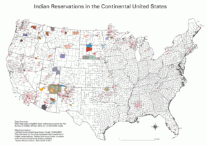
Indian reservation
An American Indian reservation is an area of land managed by a Native American tribe under the United States Department of the Interior's Bureau of Indian Affairs...
s and other tribal homelands in the United States
United States
The United States of America is a federal constitutional republic comprising fifty states and a federal district...
. In Canada
Canada
Canada is a North American country consisting of ten provinces and three territories. Located in the northern part of the continent, it extends from the Atlantic Ocean in the east to the Pacific Ocean in the west, and northward into the Arctic Ocean...
, the Indian reserve
Indian reserve
In Canada, an Indian reserve is specified by the Indian Act as a "tract of land, the legal title to which is vested in Her Majesty, that has been set apart by Her Majesty for the use and benefit of a band." The Act also specifies that land reserved for the use and benefit of a band which is not...
is a similar institution.
Reservations
Most of the tribal land base in the United States was set aside by the Federal government as Indian Reservations. In CaliforniaCalifornia
California is a state located on the West Coast of the United States. It is by far the most populous U.S. state, and the third-largest by land area...
, about half of its reservations are called Rancheria
Ranchería
The Spanish word ranchería, or rancherío, refers to a small, rural settlement. In the Americas the term was applied to native villages and to the workers' quarters of a ranch. English adopted the term with both these meanings, usually to designate the residential area of a rancho in the American...
s. In New Mexico
New Mexico
New Mexico is a state located in the southwest and western regions of the United States. New Mexico is also usually considered one of the Mountain States. With a population density of 16 per square mile, New Mexico is the sixth-most sparsely inhabited U.S...
, most reservations are called Pueblo
Pueblo
Pueblo is a term used to describe modern communities of Native Americans in the Southwestern United States of America. The first Spanish explorers of the Southwest used this term to describe the communities housed in apartment-like structures built of stone, adobe mud, and other local material...
s. In some western states, notably Nevada
Nevada
Nevada is a state in the western, mountain west, and southwestern regions of the United States. With an area of and a population of about 2.7 million, it is the 7th-largest and 35th-most populous state. Over two-thirds of Nevada's people live in the Las Vegas metropolitan area, which contains its...
, there are Native American areas called Indian Colonies
Indian colony
An Indian Colony is a Native American settlement associated with an urban area. Although some of them become official Indian reservations, they differ from most reservations in that they are located where Native Americans could find employment in mainstream American economy...
.
A
- Acoma Pueblo and Off-Reservation Trust LandAcoma Indian ReservationThe Acoma Indian Reservation is located in parts of Cibola, Socorro, and Catron counties, New Mexico, USA, and covers 594.996 sq mi . The number of tribal members is about 6000. The reservation borders the Laguna Indian Reservation to the east and is near El Malpais National Monument due west...
- Agua Caliente Indian Reservation
- Ak-Chin Indian Reservation: see Maricopa (Ak-Chin) Indian Reservation
- Alabama-Coushatta Indian Reservation
- Allegany Indian Reservation
- Alturas RancheriaAlturas RancheriaThe Alturas Indian Rancheria is a federally recognized tribe of Achomawi Indians in California.The tribe controls reservation near Alturas, California, in Modoc County. Tribal enrollment is estimated at 15. The tribe operates the Desert Rose Casino and the Rose Cafe in Alturas.The Achomawi are...
- Annette Island Reserve
- Augustine Indian Reservation
B
- Bad River Indian Reservation
- Barona Indian Reservation
- Battle Mountain Indian Reservation
- Bay Mills Indian Reservation and Off-Reservation Trust Land
- Benton Paiute Indian Reservation
- Berry Creek Rancheria and Off-Reservation Trust Land
- Big Bend RancheriaBig Bend RancheriaThe Big Bend Rancheria of the Pit River Tribe is located in California.-See also:* List of Indian reservations in the United States...
- Big Cypress Indian ReservationBig Cypress Indian ReservationThe Big Cypress Indian Reservation is an Indian reservation of the Seminole Tribe of Florida. It is located in southeastern Hendry County and northwestern Broward County in southern Florida in the United States. The reservation lies south of Lake Okeechobee and just north of Alligator Alley...
- Big Lagoon RancheriaBig Lagoon RancheriaThe Big Lagoon Rancheria is a federally recognized tribe of Yurok and Tolowa Indians. They are located in Humboldt County, California, and their tribal headquarters is in Arcata, California.-Government:...
- Big Pine Indian Reservation
- Big Sandy RancheriaBig Sandy RancheriaThe Big Sandy Rancheria of Mono Indians of California is a ranchería and federally recognized tribe of Western Mono Indians is located in Fresno County, California.-Reservation:...
- Big Valley RancheriaBig Valley RancheriaThe Big Valley Band of Pomo Indians of the Big Valley Rancheria is a federally recognized tribe of Pomo and Pit River Indians, with a reservation located in Lake County, California, near the town of Finley...
- Bishop Indian Reservation
- Blackfeet Indian ReservationBlackfeet Indian ReservationThe Blackfeet Indian Reservation or Blackfeet Nation is an Indian reservation of the Blackfeet tribe in Montana in the United States. It is located east of Glacier National Park and borders Canada to the north. Cut Bank Creek and Birch Creek make up part of its eastern and southern borders...
and Off-Reservation Trust Land - Blue Lake RancheriaBlue Lake RancheriaThe Blue Lake Rancheria of the Wiyot, Yurok, and Hupa Indians is located in Humboldt County, California.In 1966, the United States Government returned the Blue Lake Rancheria back over to the tribe and removed all Native rights from the tribe's citizens...
- Bois Forte Indian ReservationBois Forte Indian ReservationBois Forte Indian Reservation is an Indian reservation formed for the Bois Forte Band of Chippewa...
- Deer Creek Indian Reservation
- Nett Lake Indian Reservation
- Lake Vermilion Indian Reservation
- Bridgeport Indian Reservation
- Brighton Indian Reservation
- Burns Paiute Colony and Off-Reservation Trust Land
C
- Cabazon Indian Reservation
- Cahuilla Indian Reservation
- Campbell Ranch
- Campo Indian Reservation
- Capitan Grande Indian Reservation
- Carson Colony
- Catawba Indian Reservation
- Cattaraugus Indian Reservation
- Cedarville Rancheria
- Celilo Village
- Chehalis Indian Reservation
- Chemehuevi Indian Reservation
- Cheyenne River Indian ReservationCheyenne River Indian ReservationThe Cheyenne River Indian Reservation was created by the United States in 1889 by breaking up the Great Sioux Reservation, following its victory over the Lakota in a series of wars in the 1870s. The reservation covers almost all of Dewey and Ziebach counties in South Dakota...
and Off-Reservation Trust Land - Chicken Ranch Rancheria
- Chitimacha Indian Reservation
- Cochiti Pueblo
- Coconut Creek Indian Reservation
- Cocopah Indian ReservationCocopah Indian ReservationThe Cocopah Indian Reservation is the reservation of the Cocopah Indian Tribe, which represents Cocopah peoples in the United States. As of the 2000 census a resident population of 1,025 persons, of whom 519 were solely of Native American heritage, lived on the 25.948 km² Cocopah Indian...
- Coeur d'Alene Indian Reservation
- Cold Springs Rancheria
- Colorado River Indian ReservationColorado River Indian ReservationThe Colorado River Indian Reservation is 189 miles west of Phoenix, Arizona, on highway 95. It lies in western La Paz County, Arizona, southeastern San Bernardino County, California, and northeastern Riverside County, California. It has a total land area of 432.22 sq mi , and most of it lies...
- Colusa Rancheria
- Colville Indian ReservationColville Indian ReservationThe Colville Indian Reservation is an Indian reservation in the north-central part of the U.S. state of Washington, inhabited and managed by the Confederated Tribes of the Colville Reservation, which is recognized by the United States of America as an American Indian Tribe...
and Off-Reservation Trust Land - Coos, Lower Umpqua, and Siuslaw Indian Reservation and Off-Reservation Trust Land
- Coquille Indian Reservation and Off-Reservation Trust Land
- Cortina Rancheria
- Coushatta Indian Reservation
- Cow Creek Indian Reservation
- Coyote Valley Indian Reservation
- Crow Indian ReservationCrow Indian ReservationThe Crow Indian Reservation is the homeland of the Crow Tribe of Indians of the State of Montana in the United States. The reservation is located in parts of Big Horn, Yellowstone, and Treasure counties in southern Montana...
and Off-Reservation Trust Land - Crow Creek Indian Reservation
- Cuyapaipe Indian Reservation
D
- Dresslerville Colony
- Dry Creek RancheriaDry Creek RancheriaThe Dry Creek Rancheria is the land base of the Dry Creek Rancheria Band of Pomo Indians. The reservation consists today of approximately near the Russian River, in Sonoma County, approximately north of San Francisco, California....
- Duck Valley Indian ReservationDuck Valley Indian ReservationThe Duck Valley Indian Reservation was established as a homeland for members of both the Shoshone and Paiute tribes of Native Americans. It lies directly on the state line between Idaho and Nevada in the western United States...
- Duckwater Indian Reservation
E
- Eastern Cherokee Indian Reservation
- Elko Colony
- Elk Valley RancheriaElk Valley RancheriaThe Elk Valley Rancheria is a rancheria and federally recognized tribe of Tolowa and Yurok people. It is located in Del Norte County, California.-External links:*...
- Ely Indian Reservation
- Enterprise RancheriaEnterprise RancheriaEnterprise Rancheria is the landbase for the Estom Yumeka Maidu Tribe, located near Oroville, California....
F
- Fallon Paiute-Shoshone Colony
- Fallon Paiute-Shoshone Indian Reservation and Off-Reservation Trust Land
- Flandreau Indian ReservationFlandreau Indian ReservationThe Flandreau Indian Reservation is the reservation of the Santee subgroup of the Sioux tribe of Native Americans. It is located in central Moody County in eastern South Dakota, near the city of Flandreau.-Tribal Information:...
- Flathead Indian ReservationFlathead Indian ReservationThe Flathead Indian Reservation, located in western Montana on the Flathead River, is home to the Bitterroot Salish, Kootenai, and Pend d'Oreilles Tribes - also known as theConfederated Salish and Kootenai Tribes of the Flathead Nation...
- Fond du Lac Indian ReservationFond du Lac Indian ReservationThe Fond du Lac Indian Reservation is an Indian reservation in northern Minnesota near Cloquet in Carlton and St. Louis counties, with off-reservation holdings in Douglas County in Wisconsin...
and Off-Reservation Trust Land - Forest County Potawatomi CommunityForest County Potawatomi CommunityThe Forest County Potawatomi Community is a band of the Potawatomi, many of whom live on the Forest County Potawatomi Indian Reservation, most of which lies on numerous non-contiguous plots of land in southern Forest County and northern Oconto County, Wisconsin, USA. There is also a small 6.95 acre...
and Off-Reservation Trust Land - Fort Apache Indian ReservationFort Apache Indian ReservationThe Fort Apache Indian Reservation is an Indian reservation in Arizona, United States, encompassing parts of Navajo, Gila, and Apache counties. It is home to the federally recognized White Mountain Apache Tribe of the Fort Apache Reservation, a Western Apache tribe. It has a land area of 2,627.608...
- Fort Belknap Indian ReservationFort Belknap Indian ReservationThe Fort Belknap Indian Reservation is a semi-autonomous Native American-governed territory covering 1,014.064 sq mi , and is located in north central Montana. This includes the main portion of their homeland, as well as off-reservation trust land. It is shared by two Native American tribes, the...
and Off-Reservation Trust Land - Fort Berthold Indian Reservation
- Fort Bidwell Indian Reservation
- Fort Hall Indian ReservationFort Hall Indian ReservationThe Fort Hall Indian Reservation is an Indian reservation of the federally recognized Shoshone-Bannock Tribes in the U.S. state of Idaho. It is located in southeastern Idaho on the Snake River Plain north of Pocatello, and comprises 814.874 sq mi of land area in four counties: Bingham, Power,...
and Off-Reservation Trust Land - Fort Independence Indian Reservation
- Fort McDermitt Indian Reservation
- Fort McDowell Indian Reservation
- Fort Mojave Indian ReservationFort Mojave Indian ReservationThe Fort Mojave Indian Reservation is an Indian reservation along the Colorado River, currently encompassing 23,669 acres in Arizona, 12,633 acres in California, and 5,582 acres in Nevada. The reservation was originally established in 1870 and is now home to approximately 1,100 members of the...
and Off-Reservation Trust Land - Fort Peck Indian ReservationFort Peck Indian ReservationThe Fort Peck Indian Reservation is near Fort Peck, Montana. It is the homeland of the Assiniboine and Sioux tribes of Native Americans. It is the ninth-largest Indian reservation in the United States and comprises parts of four counties. In descending order of land area they are Roosevelt, Valley,...
and Off-Reservation Trust Land- Brockton
- Fort Kipp
- Frazier
- Oswego
- Poplar
- Wolf Point
- Fort Pierce Indian Reservation
- Fort Yuma Indian ReservationFort Yuma Indian ReservationThe Fort Yuma Indian Reservation is a part of the traditional lands of the Quechan people. Established in 1884, the reservation, at , has a land area of 178.197 km² in southeastern Imperial County, California, and western Yuma County, Arizona, near the city of Yuma, Arizona. Both the county...
G
- Gila River Indian Reservation
- Goshute Indian Reservation
- Grand Portage Indian ReservationGrand Portage Indian ReservationThe Grand Portage Indian Reservation is located in Cook County near the tip of Minnesota's Arrowhead Region in the extreme northeast part of the state. The community was considered part of the Lake Superior Band of Chippewa, but is not a party to the treaties that group signed...
and Off-Reservation Trust Land - Grand Ronde Community and Off-Reservation Trust Land
- Grand Traverse Indian Reservation and Off-Reservation Trust Land
- Greenville Rancheria
- Grindstone Rancheria
- Guidiville Rancheria and Off-Reservation Trust Land
H
- Hannahville Community and Off-Reservation Trust Land
- Havasupai Indian Reservation
- Ho-Chunk Indian Reservation and Off-Reservation Trust Land
- Hoh Indian Reservation
- Hollywood Indian Reservation
- Hoopa Valley Indian Reservation
- Hopi Indian Reservation and Off-Reservation Trust Land
-
- Blue Point
- Burro Springs
- East Dinnebito
- Five Houses
- Hardock
- Hopi-Winslow
- Moenkopi Administrative Area
- Moenkopi
- North Oraibi
- Polacca Wash
- RU251
- RU252
- RU253
- RU254
-
- RU255
- RU256
- RU257
- RU258
- RU259
- RU260
- RU261
- RU262
- RU263
- RU351
- RU451
- RU551
- RU552
- RU553
-
- RU554
- RU555
- RU556
- RU557
- RU558
- RU559
- RU560
- RU561
- RU562
- RU563
- RU564
- RU565
- RU566
- RU567
-
- RU568
- RU569
- RU570
- RU571
- RU572
- RU573
- Shongopovi
- Shonto
- South Oraibi
- Talahogan
- Toreva
- Tovar Mesa
- Upper Polacca
- West Dinnebito
- Hopland Rancheria and Off-Reservation Trust Land
- Houlton Maliseet Trust Land
- Hualapai Indian Reservation and Off-Reservation Trust Land
- Huron Potawatomi Indian Reservation
I
- Immokalee Indian Reservation
- Inaja and Cosmit Indian Reservation
- Indian Township Indian Reservation
- Iowa Indian Reservation and Off-Reservation Trust Land
- Isabella Indian ReservationIsabella Indian ReservationThe Isabella Indian Reservation is the land base of the Saginaw Chippewa Tribal Council, located in Isabella County in the central part of the U.S. state of Michigan. There are also some small parcels of off-reservation trust land in Standish Township, Arenac County, near Saginaw Bay, southeast of...
and Off-Reservation Trust Land - Isletai Pueblos
J
- Jackson RancheriaJackson RancheriaJackson Rancheria is the landbase for the Jackson Rancheria of Me-Wuk Indians of California, a federally recognized tribe, located near Jackson, California....
- Jamestown S'Klallam Indian Reservation and Off-Reservation Trust Land
- Jamul Indian VillageJamul Indian VillageThe Jamul Indian Village of California is a federally recognized tribe of Kumeyaay Indians, who are sometimes known as Mission Indians.-Reservation:...
- Jemez Pueblo
- Jicarilla Apache Indian Reservation
K
- Kaibab Indian ReservationKaibab Indian ReservationThe Kaibab Indian Reservation the home of the Kaibab Band of Paiute Indians, a federally recognized tribe of Southern Paiutes. The Indian reservation is located in northern part of the U.S. state of Arizona. It covers a land area of 188.75 square miles in northeastern Mohave County and...
- Kalispel Indian Reservation
- Karuk Indian Reservation and Off-Reservation Trust Land
- Kickapoo Indian Reservation
- Klamath Indian Reservation
- Kootenai Indian Reservation
L
- Lac Courte Oreilles Indian Reservation and Off-Reservation Trust Land
- Lac du Flambeau Indian Reservation
- Lac Vieux Desert Indian ReservationLac Vieux Desert Indian ReservationLac Vieux Desert Indian Reservation is an Indian reservation located in Watersmeet Township of southeastern Gogebic County, in the western part of Michigan's Upper Peninsula. It is the landbase for the Lac Vieux Desert Band of Lake Superior Chippewa. The reservation has a total land area of...
- Laguna PuebloLaguna PuebloLaguna is a Native American tribe of the Pueblo people in west-central New Mexico, USA. The name, Laguna, is Spanish and derives from the lake located on their reservation. The real Keresan name of the tribe is Kawaik. The population of the tribe exceeds 7,000 , making it the largest Keresan...
and Off-Reservation Trust Land - La Jolla Indian Reservation
- Lake Traverse Indian ReservationLake Traverse Indian ReservationThe Lake Traverse Indian Reservation is the homeland of the Sisseton–Wahpeton Oyate, a branch of the Sioux group of Native Americans. The reservation is located in parts of five counties in extreme northeastern South Dakota and parts of two counties in southeastern North Dakota, USA...
- L'Anse Indian ReservationL'Anse Indian ReservationThe L'Anse Indian Reservation is the land base of the Keweenaw Bay Indian Community of the Lake Superior Bands of Chippewa Indians . It is located primarily in two non-contiguous sections on either side of the Keweenaw Bay in Baraga County in the Upper Peninsula of the U.S. state of Michigan...
and Off-Reservation Trust Land - La Posta Indian Reservation
- Las Vegas Colony
- Laytonville Rancheria
- Leech Lake Indian ReservationLeech Lake Indian ReservationThe Leech Lake Indian Reservation or Gaa-zagaskwaajimekaag in the Ojibwe language, is an Native American reservation located in the north-central Minnesota counties of Cass, Itasca, Beltrami, and Hubbard. It is the land-base for the Leech Lake Band of Ojibwe...
and Off-Reservation Trust Land - Likely Rancheria
- Little River Indian Reservation
- Little Traverse Bay Indian Reservation
- Lone Pine Indian Reservation
- Lookout Rancheria
- Los Coyotes Indian Reservation
- Lovelock Colony
- Lower Brule Indian ReservationLower Brule Indian ReservationThe Lower Brulé Indian Reservation is an Indian reservation that belongs to the Lower Brulé Lakota Tribe. It is located on the west bank of the Missouri River in central South Dakota in the United States. It is adjacent to the Crow Creek Indian Reservation...
and Off-Reservation Trust Land - Lower Elwha Indian Reservation and Off-Reservation Trust Land
- Lower Sioux Indian ReservationLower Sioux Indian ReservationThe Lower Sioux Indian Reservation, also known as the Mdewankanton Tribal Reservation, is an Indian reservation located along the southern bank of the Minnesota River in Redwood County, Minnesota, east of the city of Redwood Falls, just south of Morton...
- Lummi Indian Reservation
M
- Makah Indian Reservation
- Manchester-Point Arena Rancheria
- Manzanita Indian Reservation
- Maricopa (Ak Chin) Indian Reservation
- Mashantucket Pequot Indian Reservation and Off-Reservation Trust Land
- Menominee Indian ReservationMenominee Indian ReservationThe Menominee Indian Reservation is an Indian reservation located in northeastern Wisconsin for the Menominee.For the most part it is conterminous with Menominee County and the town of Menominee. However, there are many small pockets of territory within the county that are not considered to be...
and Off-Reservation Trust Land - Mesa Grande Indian Reservation
- Mescalero Indian Reservation
- Miccosukee Indian ReservationMiccosukee Indian ReservationThe Miccosukee Indian Reservation is the homeland of the Miccosukee tribe of Native Americans. It is divided into three sections in two counties of southern Florida, USA. Their total land area is 128.256 sq mi...
- Middletown Rancheria
- Mille Lacs Indian ReservationMille Lacs Indian ReservationMille Lacs Indian Reservation is the land-base for the Mille Lacs Band of Ojibwe in Central Minnesota, about 100 miles north of Minneapolis-St. Paul...
and Off-Reservation Trust Land- Mille Lacs Lake Indian Reservation
- Sandy Lake Indian Reservation
- Minnesota Chippewa Trust Land
- Mississippi Choctaw Indian Reservation and Off-Reservation Trust Land
- Moapa River Indian ReservationMoapa River Indian ReservationMoapa River Indian Reservation is an Indian reservation located northeast of Las Vegas, near Moapa. It is the land-base for the Moapa Band of Paiute Indians, a local band of Southern Paiute Indians. Moapa River Indian Reservation consists of 71,954 acres .As of the year 2000, the population was 206...
- Mohegan Indian Reservation
- Montgomery Creek Rancheria
- Mooretown Rancheria
- Morongo Indian Reservation
- Muckleshoot Indian Reservation and Off-Reservation Trust Land
N
- Nambe PuebloNambé PuebloNambé Oweenge Pueblo is a pueblo in Santa Fe County, New Mexico, United States. Located about 15 miles north of Santa Fe at the base of the Sangre de Cristo Mountains. The Pueblo of Nambé has existed since the 14th century and was a primary cultural, economic, and religious center at the time of...
and Off-Reservation Trust Land - Narragansett Indian Reservation
- Navajo Nation Indian Reservation and Off-Reservation Trust Land
-
- Alamo Indian Reservation
- Aneth Chapter
- Baca Chapter
- Becenti Chapter
- Beclabito Chapter
- Bird Springs Chapter
- Black Mesa Chapter
- Bodaway Chapter
- Bread Springs Chapter
- Burnham Chapter
- Cameron Chapter
- Canoncito Indian Reservation: see Tohajiilee Indian ReservationTohajiilee Indian ReservationThe Tohajiilee Indian Reservation, formerly known as the Canoncito Indian Reservation, is a non-contiguous section of the Navajo Nation lying in parts of western Bernalillo, eastern Cibola, and southwestern Sandoval counties in New Mexico, USA, west of the city of Albuquerque. It has a land area of...
- Casamero Lake Chapter
- Chi Chil Tah Chapter
- Chilchinbeto Chapter
- Chinle Chapter
- Church Rock Chapter
- Coalmine Mesa Chapter
- Coppermine Chapter
- Cornfields Chapter
- Counselor Chapter
- Coyote Canyon Chapter
- Crownpoint Chapter
- Crystal Chapter
- Dennehotso Chapter
- Dilcon Chapter
- Forest Lake Chapter
-
- Fort Defiance Chapter
- Fruitland Chapter
- Ganado Chapter
- Greasewood Chapter
- Hard Rock Chapter
- Hogback Chapter
- Houck Chapter
- Huerfano Chapter
- Indian Wells Chapter
- Inscription House Chapter
- Iyanbito Chapter
- Jeddito Chapter
- Kaibeto Chapter
- Kayenta Chapter
- Kinlichee Chapter
- Klagetoh Chapter
- Lake Valley Chapter
- Lechee Chapter
- Leupp Chapter
- Littlewater Chapter
- Low Mountain Chapter
- Lukachukai Chapter
- Lupton Chapter
- Manuelito Chapter
- Many Farms Chapter
- Mariano Lake Chapter
- Mexican Springs Chapter
-
- Mexican Water Chapter
- Nageezi Chapter
- Nahatadziil Chapter
- Nahodishgish Chapter
- Naschitti Chapter
- Navajo Mountain Chapter
- Nazlini Chapter
- Nenahnezad Chapter
- Oak Springs Chapter
- Ojo Encino Chapter
- Oljato Chapter
- Pinedale Chapter
- Pinon Chapter
- Pueblo Pintado Chapter
- Ramah Indian Reservation
- Red Lake Chapter
- Red Mesa Chapter
- Red Rock Chapter
- Red Valley Chapter
- Rock Point Chapter
- Rock Springs Chapter
- Rough Rock Chapter
- Round Rock Chapter
- St. Michaels Chapter
- San Juan Paiute Indian Reservation
- Sanostee Chapter
- Sawmill Chapter
-
- Sheep Springs Chapter
- Shiprock Chapter
- Shonto Chapter
- Smith Lake Chapter
- Standing Rock Chapter
- Steamboat Chapter
- Sweetwater Chapter
- Tachee Chapter
- Teec Nos Pos Chapter
- Teesto Chapter
- Thoreau Chapter
- Tohajiilee Indian ReservationTohajiilee Indian ReservationThe Tohajiilee Indian Reservation, formerly known as the Canoncito Indian Reservation, is a non-contiguous section of the Navajo Nation lying in parts of western Bernalillo, eastern Cibola, and southwestern Sandoval counties in New Mexico, USA, west of the city of Albuquerque. It has a land area of...
- Tohatchi Chapter
- Tolani Lake Chapter
- Tonalea Chapter
- Torreon Chapter
- Tsaile-Wheatfields Chapter
- Tsayatoh Chapter
- Tselani Chapter
- Tuba City Chapter
- Twin Lakes Chapter
- Two Grey Hills Chapter
- Whippoorwill Chapter
- White Cone Chapter
- White Horse Lake Chapter
- White Rock Chapter
- Wide Ruins Chapter
- Nez Perce Indian Reservation
- Nisqually Indian Reservation
- Nooksack Indian Reservation and Off-Reservation Trust Land
- Northern Cheyenne Indian ReservationNorthern Cheyenne Indian ReservationThe Northern Cheyenne Indian Reservation, formerly named the Tongue River Indian Reservation, is an Indian reservation that is home to the Northern Cheyenne tribe of the Native Americans. It is located around the small towns of Lame Deer and Ashland, Montana, in parts of Rosebud and Big Horn...
and Off-Reservation Trust Land - North Fork Rancheria
- Northwestern Shoshoni Indian Reservation
O
- Oil Springs Indian ReservationOil Springs ReservationOil Springs Reservation is an Indian reservation of the Seneca tribe located in New York, USA. As of the 2010 census, the Indian reservation has one resident. Although the reservation is controlled by the Seneca tribe, as of 2005 no tribal members actually live on the Oil Springs Reservation. It is...
- Omaha Indian Reservation
- Oneida Indian Reservation, New York
- Oneida Indian Reservation, Wisconsin and Off-Reservation Trust Land
- Onondaga Indian Reservation
- Ontonagon Indian ReservationOntonagon Indian ReservationThe Ontonagon Indian Reservation is the homeland of a branch of the Lake Superior Chippewa Tribe. It is located in northeastern Ontonagon Township, in northeastern Ontonagon County, on the south shore of Lake Superior, about 20 km northeast of the village of Ontonagon, Michigan, USA...
- Osage Indian Reservation
P
- Paiute Indian Reservation
- Pala Indian ReservationPala Indian ReservationThe Pala Indian Reservation is located in the middle San Luis Rey River Valley in northern San Diego County, California, east of the community of Fallbrook, and has been assigned feature ID 272502. Historic variant names used to describe the area include Mission Indian Reservation and Mission...
- Pascua Yaqui Indian Reservation
- Passamaquoddy Trust Land
- Pauma and Yuima Indian Reservation
- Pechanga Indian Reservation
- Penobscot Indian Reservation and Off-Reservation Trust Land
- Picayune Rancheria
- Picuris Pueblo
- Pine Ridge Indian ReservationPine Ridge Indian ReservationThe Pine Ridge Indian Reservation is an Oglala Sioux Native American reservation located in the U.S. state of South Dakota. Originally included within the territory of the Great Sioux Reservation, Pine Ridge was established in 1889 in the southwest corner of South Dakota on the Nebraska border...
and Off-Reservation Trust Land - Pinoleville Rancheria
- Pit River Trust Land
- Pleasant Point Indian Reservation
- Poarch Creek Indian ReservationPoarch Creek Indian ReservationThe Poarch Creek Indian Reservation is a Creek Indian reservation in the state of Alabama. It is the home of the Poarch Band of Creek Indians, the only federally recognized Indian tribe in the state....
and Off-Reservation Trust Land - Pojoaque Pueblo
- Port Gamble Indian Reservation
- Port Madison Indian ReservationPort Madison Indian ReservationThe Port Madison Indian Reservation is an Indian reservation in northern Kitsap County, Washington. It occupies 30.273 km² on the western and northern shores of Port Madison, and is divided into two separate parcels by Miller Bay. The unincorporated towns of Suquamish and Indianola both lie...
- Prairie Band Potawatomi Indian ReservationPrairie Band Potawatomi Indian ReservationThe Prairie Band Potawatomi Indian Reservation is an Indian reservation for the Prairie Band Potawatomi Nation located in Jackson County, Kansas. The Potawatomi used to be located in the Great Lakes area, but were forced to move west due to Europeans settling their land....
- Prairie Island Indian CommunityPrairie Island Indian CommunityPrairie Island Indian Community is a Mdewakanton Sioux Indian reservation in Goodhue County, Minnesota, along the Mississippi River, in and around the city of Red Wing. It was created in 1889, with boundaries modified after that time. Much of the reservation land was lost following construction of...
and Off-Reservation Trust Land - Puyallup Indian Reservation and Off-Reservation Trust Land
- Pyramid Lake Indian ReservationPyramid Lake Indian ReservationThe Pyramid Lake Indian Reservation is a United States reservation in northwestern Nevada ~approximately northeast of Reno, in Washoe, Storey, and Lyon Counties. It lies almost entirely in Washoe County , with but tiny amounts of land in the other two counties . It is governed by the Pyramid Lake...
Q
- Quartz Valley Indian Reservation
- Quileute Indian Reservation
- Quinault Indian Reservation
R
- Ramona Village
- Red Cliff Indian Reservation and Off-Reservation Trust Land
- Redding RancheriaRedding RancheriaThe Redding Rancheria is a federal reservation in Shasta County, California, consisting of Wintun, Achomawi , and Yana Indians near Redding, California.-External links:** - With the Strength of our Ancestors on Redding Rancheria's Website...
- Red Lake Indian ReservationRed Lake Indian ReservationThe Red Lake Indian Reservation covers 1,258.62 sq mi in parts of nine counties in northern Minnesota, United States. It is divided into many pieces, although the largest piece is centered about Red Lake, in north-central Minnesota, the largest lake entirely within that state. This section lies...
- Little Rock
- Ponemah
- Redby
- Red Lake
- Redwood Valley RancheriaRedwood Valley RancheriaThe Redwood Valley Rancheria is the land reservation where the Native American community known as The Redwood Valley Band of Pomo Indians resides. It is located northeast of the town of Redwood Valley in Mendocino County, California.-Location and land status:The reservation spans on the...
- Reno-Sparks Colony
- Resighini RancheriaResighini RancheriaThe Resighini Rancheria, in Klamath, California is a Yurok Native American rancheria and a federally recognized tribe. It was formerly known as the Coast Indian Community of Yurok Indians of the Resighini Rancheria....
- Rincon Indian Reservation
- Roaring Creek Rancheria
- Robinson Rancheria and Off-Reservation Trust Land
- Rocky Boy's Indian Reservation and Off-Reservation Trust Land
- Rohnerville Rancheria
- Rosebud Indian ReservationRosebud Indian ReservationThe Rosebud Indian Reservation is an Indian reservation in South Dakota, United States. It is the home of the federally recognized Sicangu Oyate, also known as Sicangu Lakota, the Upper Brulé Sioux Nation, and the Rosebud Sioux Tribe , a branch of the Lakota people...
and Off-Reservation Trust Land - Round Valley Indian Reservation and Off-Reservation Trust Land
- Rumsey Rancheria
S
- Sac and Fox/Meskwaki Indian Reservation and Off-Reservation Trust Land
- Sac and Fox Indian Reservation and Off-Reservation Trust Land
- St. Croix Indian Reservation and Off-Reservation Trust Land
- St. Regis Mohawk Indian Reservation
- Salt River Indian Reservation
- San Carlos Indian Reservation
- Sandia PuebloSandia PuebloSandia Pueblo is a tribe of Native American Pueblo people inhabiting a 101.114 km² reservation of the same name in the eastern Rio Grande Valley of central New Mexico, located three miles south of Bernalillo off Highway 85 in southern Sandoval County and northern Bernalillo County, at...
- Sandy Lake Indian Reservation
- San Felipe Pueblo
- San Ildefonso Pueblo
- San Juan PuebloOhkay Owingeh, New MexicoOhkay Owingeh is a pueblo and census designated place in Rio Arriba County, New Mexico, United States. Its elevation is and it is located at . One of its boundaries is contiguous with Española, about north of Santa Fe....
- San Manuel Indian Reservation
- San Pasqual Indian Reservation
- Santa Ana Pueblo
- Santa Clara Pueblo
- Santa Rosa RancheriaSanta Rosa RancheriaSanta Rosa Rancheria is the reservation of the Santa Rosa Indian Community of the Santa Rosa Rancheria. It is located 4.5 miles southeast of Lemoore, California. Established in 1934 on about 40 acres , the Santa Rosa Rancheria belongs to the federally recognized Tachi Yokut tribe. It is the site...
- Santa Rosa Indian Reservation
- Santa Ynez Indian Reservation
- Santa Ysabel Indian Reservation
- Santee Indian ReservationSantee Indian ReservationThe Santee Sioux Reservation of the Santee Sioux was established in 1863. The tribal seat of government is located in Niobrara, Nebraska, with reservation lands in Knox County. Established by an Act of the U.S. Congress on March 3, 1863, the Niobrara Reservation was officially recognized in an...
- Santo Domingo Pueblo
- Sauk-Suiattle Indian Reservation
- Sault Ste. Marie Indian Reservation and Off-Reservation Trust Land
- Seminole Trust Land
- Shakopee Mdewakanton Sioux CommunityShakopee-Mdewakanton Indian ReservationThe Shakopee Mdewakanton Sioux Community is located within parts of the cities of Prior Lake and Shakopee in Scott County, Minnesota, and was previously known as Prior Lake Indian Reservation until it was modified by the Indian Reorganization Act on November 28, 1969. As of the 2000 census, there...
and Off-Reservation Trust Land - Sherwood Valley Rancheria
- Shingle Springs Rancheria
- Shoalwater Bay Indian Reservation and Off-Reservation Trust Land
- Siletz Indian Reservation and Off-Reservation Trust Land
- Skokomish Indian Reservation
- Skull Valley Indian Reservation
- Smith River Rancheria
- Soboba Indian Reservation
- Sokaogon Chippewa CommunitySokaogon Chippewa CommunityThe Sokaogon Chippewa Community, or the Mole Lake Band of Lake Superior Chippewa, is a band of the Lake Superior Chippewa, many of whom reside on the Mole Lake Indian Reservation, an Indian reservation located at in Mole Lake, Wisconsin, in Forest County near Crandon.The Mole Lake Indian...
and Off-Reservation Trust Land - Southern Ute Indian ReservationSouthern Ute Indian ReservationThe Southern Ute Indian Reservation lies in southwestern Colorado, USA, along the northern border of New Mexico. Its territory consists of land from three counties; in descending order of surface area they are La Plata, Archuleta, and Montezuma Counties. The reservation has a land area of 1,058.785...
- South Fork Indian Reservation and Off-Reservation Trust Land
- Spirit Lake Indian Reservation
- Spokane Indian Reservation
- Squaxin Island Indian Reservation and Off-Reservation Trust Land
- Standing Rock Indian ReservationStanding Rock Indian ReservationThe Standing Rock Indian Reservation is a Lakota, Yanktonai and Dakota Indian reservation in North Dakota and South Dakota in the United States...
- Stewart Community
- Stewarts Point Rancheria
- Stillaguamish Indian Reservation
- Stockbridge-Munsee CommunityStockbridge-Munsee CommunityThe Stockbridge-Munsee Community is a Federally recognized Indian tribe consisting of the Mahican and Munsee peoples. Their land-base, the Stockbridge-Munsee Indian Reservation, is located at in Shawano County, Wisconsin, in the towns of Bartelme and Red Springs.-In popular culture:In The West...
- Sulphur Bank Rancheria
- Summit Lake Indian Reservation
- Susanville Rancheria
- Swinomish Indian Reservation
- Sycuan Indian Reservation
T
- Table Bluff Indian Reservation and Off-Reservation Trust Land
- Table Mountain RancheriaTable Mountain RancheriaThe Table Mountain Rancheria is a federally recognized tribe of Native American people from the Chukchansi band of Yokuts and the Monache tribe. It is also the tribe's ranchería, located in Fresno County, California.-Reservation:...
- Tampa Indian Reservation
- Taos PuebloTaos PuebloTaos Pueblo is an ancient pueblo belonging to a Taos speaking Native American tribe of Pueblo people. It is approximately 1000 years old and lies about north of the modern city of Taos, New Mexico, USA...
and Off-Reservation Trust Land - Tesuque Pueblo and Off-Reservation Trust Land
- Tohono O'odham Indian Reservation and Off-Reservation Trust Land
- Tonawanda Indian Reservation
- Tonto Apache Indian Reservation
- Torres-Martinez Indian Reservation
- Trinidad Rancheria and Off-Reservation Trust Land
- Tulalip Indian Reservation
- Tule River Indian Reservation
- Tunica-Biloxi Indian Reservation
- Tuolumne Rancheria and Off-Reservation Trust Land
- Turtle Mountain Indian ReservationTurtle Mountain Indian ReservationTurtle Mountain Indian Reservation is an Indian Reservation located primarily in northern North Dakota. It is the land-base for the Turtle Mountain Band of Chippewa Indians ....
and Off-Reservation Trust Land - Tuscarora Indian Reservation
- Twenty-Nine Palms Indian Reservation
U
- Uintah and Ouray Indian ReservationUintah and Ouray Indian ReservationThe Uintah and Ouray Indian Reservation is located in northeastern Utah, USA. It is the homeland of the Northern Ute Tribe, and is the largest of three Indian reservations inhabited by members of the Ute Tribe of Native Americans. It lies in parts of seven counties; in descending order of land area...
and Off-Reservation Trust Land - Umatilla Indian ReservationUmatilla Indian ReservationThe Umatilla Indian Reservation is an Indian reservation in eastern Oregon in the United States, mostly located in Umatilla County, with a very small part extending south into Union County...
- Upper Lake Rancheria
- Upper Sioux Indian ReservationUpper Sioux Indian ReservationThe Upper Sioux Indian Reservation is located in Minnesota Falls Township along the Minnesota River in eastern Yellow Medicine County, Minnesota, five miles south of Granite Falls. It was created in 1938 when 746 acres of land were returned to the tribe...
- Upper Skagit Indian Reservation
- Ute Mountain Ute TribeUte Mountain Ute TribeThe Ute Mountain Ute Tribe is one of three federally recognized tribes of the Ute Nation, and are mostly descendants of the historic Weeminuche Band who moved to the Southern Ute reservation in 1897...
Reservation and Off-Reservation Trust Land
W
- Walker River Indian ReservationWalker River Indian ReservationThe Walker River Indian Reservation is an Indian reservation located in central Nevada in the United States. It is located along the Walker River between Yerington and Walker Lake. At the current lake level, the reservation has only a small frontage on Walker Lake...
- Wampanoag-Aquinnah Trust Land
- Warm Springs Indian ReservationWarm Springs Indian ReservationThe Warm Springs Indian Reservation consists of 1,019.385 sq mi in north central Oregon, in the United States, and is occupied and governed by the Confederated Tribes of Warm Springs.-Tribes:...
and Off-Reservation Trust Land - Wells Colony
- White Earth Indian ReservationWhite Earth Indian ReservationThe White Earth Indian Reservation is the home to the White Earth Nation, located in northwestern Minnesota. It is the largest Indian reservation in that state...
and Off-Reservation Trust Land - Wind River Indian ReservationWind River Indian ReservationWind River Indian Reservation is an Indian reservation shared by the Eastern Shoshone and Northern Arapaho tribes of Native Americans in the central western portion of the U.S. state of Wyoming...
- Winnebago Indian Reservation and Off-Reservation Trust Land
- Winnemucca Colony
- Woodfords Community
Y
- Yakama Indian ReservationYakama Indian ReservationThe Yakama Indian Reservation is a United States Indian reservation located on the east side of the Cascade Mountains in southern Washington. It is the homeland of the Yakama tribe of Native Americans....
and Off-Reservation Trust Land - Yankton Indian ReservationYankton Indian ReservationThe Yankton Indian Reservation is the homeland of the Yankton subgroup of the Sioux tribe of Native Americans.The reservation occupies the southeasternmost 60 percent of Charles Mix County in southeastern South Dakota, United States...
- Yavapai-Apache Nation Indian Reservation
- Yavapai-Prescott Indian Reservation
- Yerington Colony
- Yomba Indian Reservation
- Ysleta Del Sur PuebloYsleta Del Sur PuebloYsleta del Sur Pueblo is a Puebloan Native American tribal entity in the Ysleta section of El Paso, Texas, comprising a formerly Southern Tiwa-speaking people who were displaced from New Mexico in 1680 and 1681 during the Pueblo Revolt against the Spaniards.-Tigua:In Spanish the people and...
and Off-Reservation Trust Land - Yurok Indian ReservationYurok Indian ReservationThe Yurok Tribe of the Yurok Reservation is located in parts of Del Norte and Humboldt counties, California, on a 44-mile stretch of the Klamath River. It is a rancheria of Yurok people and a federally recognized tribe....
Z
- Zia Pueblo and Off-Reservation Trust Land
- Zuni Indian ReservationZuni Indian ReservationThe Zuni Indian Reservation is the homeland of the Zuni tribe of Native Americans. It lies in the Zuni River valley and is located primarily in McKinley and Cibola counties in western New Mexico, about west of Albuquerque. There are also several smaller non-contiguous sections in Apache County,...
and Off-Reservation Trust Land
Joint Use Areas
- Hopi/Navajo JUA: see Navajo Indian Reservation
- Kickapoo/Sac and Fox JUA
- Menominee/Stockbridge-Munsee JUA
- San Felipe/Santa Ana JUA
- San Felipe/Santo Domingo JUA
Oklahoma Tribal Statistical Areas
Oklahoma Tribal Statistical Area is a statistical entity identified and delineated by federally recognized American Indian tribes in Oklahoma that formerly had a reservation but do not now have a reservation in that state. Often, an OTSA will be that of the former Indian Reservation in Oklahoma.- Caddo-Wichita-Delaware OTSA
- Cherokee OTSA
- Cheyenne-Arapaho OTSA
- Chickasaw OTSA
- Choctaw OTSA
- Citizen Potawatomi Nation-Absentee Shawnee OTSA
- Creek OTSA
- Eastern Shawnee OTSA
- Iowa OTSA
- Kaw OTSA
- Kickapoo OTSA
- Kiowa-Comanche-Apache-Fort Sill Apache OTSA
- Miami OTSA
- Modoc OTSA
- Otoe-Missouria OTSA
- Ottawa OTSA
- Pawnee OTSA
- Peoria OTSA
- Ponca OTSA
- Quapaw OTSA
- Sac and Fox OTSA
- Seminole OTSA
- Seneca-Cayuga OTSA
- Tonkawa OTSA
- Wyandotte OTSA
Joint Use Areas
- Creek-Seminole JUA OTSA
- Kaw-Ponca JUA OTSA
- Kiowa-Comanche-Apache-Ft. Sill Apache-Caddo-Wichita-Delaware JUA OTSA
- Miami-Peoria JUA OTSA
Hawaiian Homelands
- Anahola-Kamalomalo
- Auwaiolimu-Kalawahine-Kewalo-Papakolea
- Hanapepe
- Hoolehua-Palaau
- Honokaia
- Honokohau
- Honomu-Kuhua
- Humuula
- Kahikinui
- Kalamaula
- Kalaoa
- Kalaupapa
- Kamaoa-Puueo
- Kamiloloa
- Kamoku-Kapulena
- Kaniohale
- Kapaa
- KapaakeaKapaakeaCaesar Kaluaiku Kapaakea was a Hawaiian chief who was the patriarch of the House of Kalākaua that ruled the Kingdom of Hawaii during the last of its days.-Biography:...
- KapalamaKapālama-History:The name comes from ka pā lama in the Hawaiian language which means "the enclosure of lama wood". "Lama" was the Hawaiian name for endemic ebony trees of genus Diospyros that were used in religious ceremonies....
- Kapolei
- Kaumana
- KawaihaeKawaihaeKawaihae is an unincorporated community on the west side of the island of Hawaii in the U.S. state of Hawaii, north of Kailua-Kona. Its harbor includes a fuel depot, shipping terminal and military landing site. Outside of the man-made breakwall of the harbor is a popular surf spot and the Pua...
- Keanae
- Kealakehe
- Keaukaha
- Kekaha
- Keoniki
- KulaKula, HawaiiKula is a district of Maui, Hawaii that stretches across the "up-country", the western-facing slopes of Haleakalā, from Makawao to Ulupalakua. Most of the residential areas lie between about 500 to 1,100 m in elevation...
- Lahaina
- Lalamilo
- Lualualei
- Makakupia
- Makuu
- Moiliili
- Moloaa
- Nanakuli
- Nienie
- Olaa
- Panaewa
- Pauahi
- Paukukalo
- Pihonua
- Ponohawai
- Puukapu
- PuunenePuunenePuunēnē is an unincorporated town in the central part of Maui, Hawaii, near Kahului. Although the land in that area is fairly level, the words Puu nēnē mean "nene goose hill" in Hawaiian...
- PunaPuna, HawaiiPuna is one of the nine districts in Hawaii County, Big Island, Hawaii. The District of Puna is located on the easternmost portion of the island and shares borders to the north with the District of South Hilo and a border to the west with the District of Kaū...
- Shafter Flats
- Ualapue
- Ulupalakua
- Waianae
- WaiohinuWaiohinuWaiohinu is an unincorporated community in the district of Ka'u on the island of Hawaii in the U.S. state of Hawaii. Waiohinu is the name of the community as well as the ahupua'a, Native Hawaiian subdivision.-Landmarks:...
- WaiakeaWaiakeaWaiākea is an ancient subdivision in the Hilo District of the Big Island of Hawaii, located in the area of .-Origin:The name comes from wai ākea in the Hawaiian Language meaning "broad waters", and sometimes what is now called Hilo Bay was called Waiākea Bay.Waiākea is home to many and has its own...
- Waiehu
- Waikoloa-Waialeale
- WailauWailauWailau, also known as East Molokai Volcano, is an extinct shield volcano comprising the eastern two-thirds of the island of Molokai in the U.S. state of Hawaii.-Description:...
- Wailua
- Wailua
- Wailuku
- Waimanalo
- WaimanuWaimanu ValleyWaimanu Valley is a remote valley on the northeast coast of Hawaii island. Besides the main Waimanu Stream, it includes Waihīlau Falls on a tributary.-Description:...
- Waimea
Alaska Native Village Statistical Areas
Alaska NativesAlaska Natives
Alaska Natives are the indigenous peoples of Alaska. They include: Aleut, Inuit, Tlingit, Haida, Tsimshian, Eyak, and a number of Northern Athabaskan cultures.-History:In 1912 the Alaska Native Brotherhood was founded...
previously had many small reserves scattered around Alaska
Alaska
Alaska is the largest state in the United States by area. It is situated in the northwest extremity of the North American continent, with Canada to the east, the Arctic Ocean to the north, and the Pacific Ocean to the west and south, with Russia further west across the Bering Strait...
; however, all but one (the Annette Island Reserve of Tsimshian
Tsimshian
The Tsimshian are an indigenous people of the Pacific Northwest Coast. Tsimshian translates to Inside the Skeena River. Their communities are in British Columbia and Alaska, around Terrace and Prince Rupert and the southernmost corner of Alaska on Annette Island. There are approximately 10,000...
) were repealed with the passage of the Alaska Native Claims Settlement Act
Alaska Native Claims Settlement Act
The Alaska Native Claims Settlement Act, commonly abbreviated ANCSA, was signed into law by President Richard M. Nixon on December 23, 1971, the largest land claims settlement in United States history. ANCSA was intended to resolve the long-standing issues surrounding aboriginal land claims in...
in 1971.
- Akhiok, AlaskaAkhiok, AlaskaAkhiok is a 2nd class city in Kodiak Island Borough, Alaska, United States. Akhiok is Kodiak's southernmost village. The population was 80 at the 2000 census. Akhiok, which does not have a post office, is a rural location in postal code 99615 which belongs to Kodiak...
- Akiachak, AlaskaAkiachak, AlaskaAkiachak is a census-designated place in the Bethel Census Area in the U.S. state of Alaska. The population was 585 at the 2000 census.-Geography and climate:...
- Akiak, AlaskaAkiak, AlaskaAkiak is a city in Bethel Census Area, Alaska, United States. The population was 309 at the 2000 census....
- Akutan, AlaskaAkutan, AlaskaAkutan is a city in Aleutians East Borough, Alaska, United States. The population was 713 at the 2000 census. In 2009, the population was 812.-Geography:Akutan is located at...
- Alakanuk, AlaskaAlakanuk, AlaskaAlakanuk is a 2nd-class city in the Wade Hampton Census Area of the Unorganized Borough in the western part of the U.S. state of Alaska. As of the 2000 census, the population of the city was 652....
- Alatna, AlaskaAlatna, AlaskaAlatna is a census-designated place in the Yukon-Koyukuk Census Area of the Unorganized Borough in the U.S. state of Alaska. The population was 35 at the 2000 census.-Geography:Alatna is located at Alatna is a census-designated place (CDP) in the Yukon-Koyukuk Census Area of the Unorganized...
- Aleknagik, AlaskaAleknagik, AlaskaAleknagik is a second class city in the Dillingham Census Area of the Unorganized Borough of the U.S. state of Alaska. The population was 221 at the 2000 census.-Geography:...
- Algaacig, Alaska
- Allakaket, AlaskaAllakaket, AlaskaAllakaket is a 2nd Class City in the Yukon-Koyukuk Census Area of the Unorganized Borough of the U.S. state of Alaska. The population was 97 at the 2000 census.-Geography and climate:...
- Ambler, AlaskaAmbler, AlaskaAmbler is a city in Northwest Arctic Borough, Alaska, United States. At the 2000 census the population was 309. The city is located in the large Inupiaq language speaking region of Alaska, and the local dialect is known as the Ambler dialect...
- Anaktuvuk Pass, AlaskaAnaktuvuk Pass, AlaskaAnaktuvuk Pass is a city in North Slope Borough, Alaska, United States. The population was 249 at the 2007 Census Bureau estimate.-Geography:...
- Andreafsky, Alaska
- Angoon, AlaskaAngoon, AlaskaAngoon is a city on Admiralty Island in Hoonah-Angoon Census Area, Alaska, United States. At the 2000 census the population was 572, by the 2010 census the population had declined to 459...
- Aniak, AlaskaAniak, AlaskaAniak is a city in the Bethel Census Area in the U.S. state of Alaska. At the 2000 census the population was 572.-Geography: ....
- Anvik, AlaskaAnvik, AlaskaAnvik is a city, home to the Deg Hit'an people, in the Yukon-Koyukuk Census Area, Alaska, United States. The name Anvik, which became the common usage despite multiple names at the time, may have come from early Russian explorers. The native name in the Deg Xinag language is Deloy Ges...
- Arctic Village, AlaskaArctic Village, AlaskaArctic Village is an unincorporated Native American village and a census-designated place in Yukon-Koyukuk Census Area, Alaska, United States. As of the 2000 census, the population of the CDP was 152. The village is located in the large Gwitch'in speaking region of Alaska, and the local dialect...
- Atka, AlaskaAtka, AlaskaAtka is a hamlet located on the east side of Atka Island, in Aleutians West Census Area, Alaska, United States. The population was 61 at the 2010 census.The population of Atka is nearly entirely Aleut . The major industry is fishing.-Geography:...
- Atmautluak, AlaskaAtmautluak, AlaskaAtmautluak is a census-designated place in Bethel Census Area, Alaska, United States. The population was 294 at the 2000 census.-History:The area has been traditionally been inhabited by Yup'ik Eskimo....
- Atqasuk, AlaskaAtqasuk, AlaskaAtqasuk is a city in North Slope Borough, Alaska, United States. At the 2000 census the population was 228.-Geography:Atqasuk is located at ....
- Barrow, AlaskaBarrow, AlaskaBarrow is the largest city of the North Slope Borough in the U.S. state of Alaska. It is one of the northernmost cities in the world and is the northernmost city in the United States of America, with nearby Point Barrow being the nation's northernmost point. Barrow's population was 4,212 at the...
- Beaver, AlaskaBeaver, AlaskaBeaver is a census-designated place in Yukon-Koyukuk Census Area, Alaska, United States. At the 2000 census the population was 84.-Geography:Beaver is located at ....
- Belkofski, AlaskaBelkofski, AlaskaBelkofoski is a small community located in the Aleutians East Borough in Alaska.- Location :Belkofski is located on a point at the eastern end of the Alaska Peninsula, 12 miles southeast of King Cove.- History :...
- Bethel, AlaskaBethel, AlaskaBethel is a city located near the west coast of the U.S. state of Alaska, west of Anchorage. Accessible only by air and river, Bethel is the main port on the Kuskokwim River and is an administrative and transportation hub for the 56 villages in the Yukon-Kuskokwim Delta.Bethel is the largest...
- Bill Moore's, Alaska
- Birch Creek, AlaskaBirch Creek, AlaskaBirch Creek is a census-designated place in Yukon-Koyukuk Census Area, Alaska, United States. The population was 28 at the 2000 census.-Geography:...
- Brevig Mission, AlaskaBrevig Mission, AlaskaBrevig Mission is a city in Nome Census Area, Alaska. The population was 276 at the 2000 census.-Geography:Brevig Mission is located at ....
- Buckland, AlaskaBuckland, AlaskaBuckland is a city in Northwest Arctic Borough, Alaska, United States. At the 2000 census the population was 406.-Geography:Buckland is located at ....
- Cantwell, AlaskaCantwell, AlaskaCantwell was a railway flag stop at the junction with the Denali Highway. The original town is off the Parks Highway. It is a census-designated place in Denali Borough, Alaska, United States...
- Chalkyitsik, AlaskaChalkyitsik, AlaskaChalkyitsik is a census-designated place in Yukon-Koyukuk Census Area, Alaska, United States. At the 2000 census the population was 83.-Geography:Chalkyitsik is located at ....
- Chefornak, AlaskaChefornak, AlaskaChefornak is a city in Bethel Census Area, Alaska, United States. At the 2000 census the population was 394.-Geography:Chefornak is located at ....
- Chenega, AlaskaChenega, AlaskaChenega is a census-designated place on Evans Island in the Valdez-Cordova Census Area in the U.S. state of Alaska. Located in Prince William Sound, the CDP consists of the Chugach Alutiiq village of Chenega Bay, which was established only after the Good Friday Earthquake destroyed the original...
- Chevak, AlaskaChevak, AlaskaChevak is a city in Wade Hampton Census Area, Alaska, United States. At the 2000 census the population was 765....
- Chickaloon, AlaskaChickaloon, AlaskaChickaloon is a census-designated place in Matanuska-Susitna Borough, Alaska, United States. It is part of the Anchorage, Alaska Metropolitan Statistical Area...
- Chignik, AlaskaChignik, Alaska-External links:* / by Mark A. Stichert. Hosted by the ....
- Chignik Lagoon, AlaskaChignik Lagoon, AlaskaChignik Lagoon is a census-designated place in Lake and Peninsula Borough, Alaska, United States. At the 2000 census the population was 103.-Geography:Chignik Lagoon is located at ....
- Chignik Lake, AlaskaChignik Lake, AlaskaChignik Lake is a census-designated place in Lake and Peninsula Borough, Alaska, United States. At the 2000 census the population was 145.-Geography:Chignik Lake is located at ....
- Chilkat, Alaska
- Chilkoot, Alaska
- Chistochina, AlaskaChistochina, AlaskaChistochina is a census-designated place in Valdez-Cordova Census Area, Alaska, United States. At the 2000 census the population was 93.-Geography:Chistochina is located at ....
- Chitina, AlaskaChitina, AlaskaChitina is a census-designated place in Valdez-Cordova Census Area, Alaska, United States. At the 2000 census the population was 123.-Geography:Chitina is located at ....
- Chuathbaluk, AlaskaChuathbaluk, AlaskaChuathbaluk is a city in Bethel Census Area, Alaska, United States. At the 2000 census the population was 119.-Geography:Chuathbaluk is located at ....
- Chulloonawick, Alaska
- Circle, AlaskaCircle, AlaskaCircle is a census-designated place in Yukon-Koyukuk Census Area, Alaska, United States. At the 2000 census the population was 100....
- Clark's Point, AlaskaClark's Point, AlaskaClark's Point is a city in Dillingham Census Area, Alaska, United States. The population was 75 at the 2000 census.-Geography:Clark's Point is located at ....
- Copper Center, AlaskaCopper Center, AlaskaCopper Center is a census-designated place in Valdez-Cordova Census Area, Alaska, United States. At the 2000 census the population was 362.-Geography:Copper Center is located at ....
- Council, AlaskaCouncil, AlaskaCouncil is an abandoned townsite in the Nome Census Area in the U.S. state of Alaska.- Geography :Council is located at about , about 57 miles east by northeast of Nome. It is located on the banks of the Niukluk River on the central Seward Peninsula....
- Craig, AlaskaCraig, AlaskaCraig is a first-class city in the Prince of Wales-Hyder Census Area in the Unorganized Borough in the U.S. state of Alaska. The population was 1,397 at the 2000 census.-Geography:...
- Crooked Creek, AlaskaCrooked Creek, AlaskaCrooked Creek is a census-designated place in Bethel Census Area, Alaska, United States. As of the 2000 census, the population of the CDP is 137.-Geography:Crooked Creek is located at ....
- Deering, AlaskaDeering, AlaskaDeering is a city in the Northwest Arctic Borough in the U.S. state of Alaska. It is located on a sandy spit on the Seward Peninsula where the Inmachuk River flows into Kotzebue Sound, southwest of Kotzebue....
- Dillingham, AlaskaDillingham, Alaska- Natural resources :Dillingham was once known as the Pacific salmon capital of the world and commercial fishing remains an important part of the local economy...
- Dot Lake, AlaskaDot Lake, AlaskaDot Lake is a census-designated place in Southeast Fairbanks Census Area, Alaska, United States. It is located on the Alaska Highway between Delta Junction and Tok...
- Douglass, Alaska
- Eagle, AlaskaEagle, AlaskaEagle is a city located along the United States-Canada border in the Southeast Fairbanks Census Area, Alaska, United States. It includes Eagle Historic District, a U.S. National Historic Landmark. The population was 129 at the 2000 census...
- Eek, AlaskaEek, AlaskaEek is a city in Bethel Census Area, Alaska, United States. At the 2000 census the population was 280.-Geography:Eek is located at ....
- Egegik, AlaskaEgegik, AlaskaEgegik is a city in Lake and Peninsula Borough, Alaska, United States. As of the 2000 census, the population of the city is 116.-Geography:...
- Eklutna, AlaskaEklutna, AlaskaEklutna is a native village within the Municipality of Anchorage in the U.S. state of Alaska. The Tribal Council estimates the population at 70; many tribal members live in the surrounding communities....
- Ekuk, AlaskaEkuk, AlaskaEkuk is a small unincorporated community in the Dillingham Census Area in the U.S. state of Alaska. Until 2002 it was the site of a large fish processing operation owned by Ward's Cove Packing Company...
- Ekwok, AlaskaEkwok, AlaskaEkwok is a city in Dillingham Census Area, Alaska, United States. At the 2000 census the population was 130.-Geography:Ekwok is located at ....
- Emmonak, AlaskaEmmonak, AlaskaEmmonak is a city in Wade Hampton Census Area, Alaska, United States. At the 2000 census the population was 767.-Geography:Emmonak is located at ....
- Evansville, AlaskaEvansville, AlaskaEvansville is a census-designated place in Yukon-Koyukuk Census Area, Alaska, United States. The population was 28 at the 2000 census.-Geography:Evansville is located at ....
- Eyak, Alaska
- False Pass, AlaskaFalse Pass, AlaskaFalse Pass is a city in Aleutians East Borough, Alaska, United States. Isanax̂ is the Aleut name for present day Isanotski Strait and means gap, hole, rent, or tear in the Aleut language which was rendered as Isanotski in transliterated Russian...
- Fort Yukon, AlaskaFort Yukon, AlaskaAs of the census of 2000, there were 595 people, 225 households, and 137 families residing in the city. The population density was 85.0 people per square mile . There were 317 housing units at an average density of 45.3 per square mile...
- Gakona, AlaskaGakona, AlaskaGakona is a census-designated place in the Valdez-Cordova Census Area in the U.S. state of Alaska. As of the 2000 census, the population of the CDP was 215.-Geography and climate:...
- Galena, AlaskaGalena, AlaskaGalena is the largest city in the Yukon-Koyukuk Census Area in the U.S. state of Alaska. At the 2000 census the population was 675.-History:...
- Gambell, AlaskaGambell, AlaskaGambell is a village on St. Lawrence Island in Alaska, United States. At the 2000 census the population was 649.-Geography:Gambell is located on the northwest cape of St. Lawrence Island in the Bering Sea, southwest of Nome...
- Georgetown, AlaskaGeorgetown, AlaskaGeorgetown is an unincorporated Alaska Native village located in the Bethel Census Area of the U.S. state of Alaska. The population as of the 2000 census was 3.- Geography :...
- Golovin, AlaskaGolovin, AlaskaGolovin is a city in Nome Census Area, Alaska, United States. At the 2000 census the population was 144.-Geography:Golovin is located at ....
- Goodnews Bay, AlaskaGoodnews Bay, AlaskaGoodnews Bay is a city in Bethel Census Area, Alaska, USA. As of the 2000 census, the population of the city is 230.-Geography:...
- Grayling, AlaskaGrayling, AlaskaGrayling is a city in Yukon-Koyukuk Census Area, Alaska, United States. At the 2000 census the population was 194. Since 1977, the Athabaskan village has seen a surge of interest on odd-numbered years, when it is the site of a checkpoint during the Iditarod Trail Sled Dog Race...
- Gulkana, AlaskaGulkana, AlaskaGulkana is a census-designated place in Valdez-Cordova Census Area, Alaska, U.S. At the 2000 census the population was 88.-Geography:Gulkana is located at ....
- Hamilton, Alaska
- Healy Lake, AlaskaHealy Lake, AlaskaHealy Lake is a census-designated place in Southeast Fairbanks Census Area, Alaska, United States. The population was 37 at the 2000 census.-Geography:Healy Lake is located at ....
- Holy Cross, AlaskaHoly Cross, AlaskaHoly Cross is a city in Yukon-Koyukuk Census Area, Alaska, United States...
- Hoonah, AlaskaHoonah, AlaskaHoonah is a Tlingit community on Chichagof Island, located in Alaska's "panhandle" in the southeast region of the state. It is 30 miles west of Juneau, across the Alaskan Inland Passage. Hoonah is the only first-class city on Chichagof Island, the 109th largest island in the world and the 5th...
- Hooper Bay, AlaskaHooper Bay, AlaskaHooper Bay or Naparyarmiut is a city in Wade Hampton Census Area, Alaska, United States. At the 2000 census the population was 1,014. The Boards of Canada EP Hooper Bay was named after the city....
- Hughes, AlaskaHughes, AlaskaHughes is a city in Yukon-Koyukuk Census Area, Alaska, United States. The population was 78 at the 2000 census.-Geography:According to the United States Census Bureau, the city has a total area of , all of it land....
- Huslia, AlaskaHuslia, AlaskaHuslia is a village of Koyukuk-hotana Athabascans in Yukon-Koyukuk Census Area, Alaska, United States. Rarely known as Hussliakatna...
- Hydaburg, AlaskaHydaburg, AlaskaHydaburg is a town in the Prince of Wales-Hyder Census Area, in the U.S. state of Alaska. The population was 382 at the 2000 census.-Geography:Hydaburg is located at . It is the southernmost city on Prince of Wales Island...
- Igiugig, AlaskaIgiugig, AlaskaIgiugig is a census-designated place in Lake and Peninsula Borough, Alaska, United States. The population was 53 at the 2000 census. The village is at the mouth of the Kvichak River, on Lake Iliamna, in the U.S...
- Iliamna, AlaskaIliamna, AlaskaIliamna is a census-designated place in Lake and Peninsula Borough, Alaska, United States. The population was 102 at the 2000 census.-Geography:Iliamna is located at ....
- Inalik, Alaska
- Ivanof Bay, AlaskaIvanof Bay, AlaskaIvanof Bay is a census-designated place in Lake and Peninsula Borough, Alaska, United States. The population was seven at the 2010 Census.- Geography :Ivanof Bay is located at ....
- Kake, AlaskaKake, AlaskaKake is a town in Petersburg Census Area, Alaska, United States. The population was 710 at the 2000 census. The name comes from the Tlingit word or , which is derived from “dawn, daylight” and “mouth”, i.e. “mouth of dawn” or “opening of daylight”.-Geography:Kake is located at...
- Kaktovik, AlaskaKaktovik, AlaskaKaktovik is a city in North Slope Borough, Alaska, United States. As of the 2000 census, the population of the city was 293.-Geography:Kaktovik is located at ....
- Kalskag, AlaskaKalskag, AlaskaKalskag, Alaska may refer to:*Lower Kalskag, Alaska*Upper Kalskag, Alaska...
- Kaltag, AlaskaKaltag, AlaskaKaltag is a village in Yukon-Koyukuk Census Area, Alaska, United States. At the 2000 census the population was 230.-Geography:Kaltag is located at ....
- Karluk, AlaskaKarluk, AlaskaKarluk is a census-designated place in Kodiak Island Borough, Alaska, United States. The population was 27 at the 2000 census.-Geography:Karluk is located at...
- Kasaan, AlaskaKasaan, AlaskaKasaan is a city in the Prince of Wales-Hyder Census Area in the U.S. state of Alaska. The population was 39 at the 2000 census.-History:Kasaan is one of the main historical communities of the Kaigani Haida...
- Kasigluk, AlaskaKasigluk, AlaskaKasigluk is a census-designated place in the Bethel Census Area in the U.S. state of Alaska. At the 2000 census the population was 543...
- Kenaitze, Alaska
- Kiana, AlaskaKiana, AlaskaKiana is a city in Northwest Arctic Borough, Alaska, United States. At the 2000 census the population was 388.-Geography:Kiana is located at ....
- King Cove, AlaskaKing Cove, AlaskaKing Cove is a city in Aleutians East Borough, Alaska, United States. At the 2000 census the population was 792.-Geography:...
- Kipnuk, AlaskaKipnuk, AlaskaKipnuk is a census-designated place in Bethel Census Area, Alaska, United States. At the 2000 census the population was 644....
- Kivalina, AlaskaKivalina, AlaskaKivalina is a city in Northwest Arctic Borough, Alaska, United States. At the 2000 census the population was 377.-History:...
- Klawock, AlaskaKlawock, AlaskaKlawock is a city in Prince of Wales-Hyder Census Area, in the U.S. state of Alaska, on the west coast of Prince of Wales Island, on Klawock Inlet, across from Klawock Island...
- Knik, AlaskaKnik, Alaska-Alaska:* Knik, Alaska, a ghost town located southwest of Wasilla. The townsite, listed on the National Register of Historic Places, lies within the Knik-Fairview census-designated place boundaries .-Census-designated places:* Knik-Fairview, Alaska...
- Kobuk, AlaskaKobuk, AlaskaKobuk is a city in Northwest Arctic Borough, Alaska, United States. At the 2000 census the population was 109.-Geography:Kobuk is located at ....
- Kokhanok, AlaskaKokhanok, AlaskaKokhanok is a census-designated place in Lake and Peninsula Borough, Alaska, United States. At the 2000 census the population was 174.-Geography:Kokhanok is located at ....
- Kongiganak, AlaskaKongiganak, AlaskaKongiganak is a census-designated place in Bethel Census Area, Alaska, United States. At the 2000 census the population was 359.-Geography:Kongiganak is located at ....
- Kotlik, AlaskaKotlik, AlaskaKotlik is a city in Wade Hampton Census Area, Alaska, United States. At the 2000 census the population was 591.-Geography:Kotlik is located at...
- Kotzebue, AlaskaKotzebue, AlaskaAs of the census of 2000, there were 3,082 people, 889 households, and 656 families residing in the city. The population density was 114.1 people per square mile . There were 1,007 housing units at an average density of 37.3 per square mile...
- Koyuk, AlaskaKoyuk, AlaskaKoyuk is a city in the Nome Census Area, Alaska, United States. The population was 297 at the 2000 census.-Geography:Koyuk is located at...
- Koyukuk, AlaskaKoyukuk, AlaskaKoyukuk is a city in Yukon-Koyukuk Census Area, Alaska, United States At the 2000 census the population was 101., Koyukuk is one of a number of Alaskan communities threated by erosion.-History:...
- Kwethluk, AlaskaKwethluk, AlaskaKwethluk is a city in Bethel Census Area in the U.S. state of Alaska. At the 2000 census the population was 713.-Geography:...
- Kwigillingok, AlaskaKwigillingok, AlaskaKwigillingok is a census-designated place in Bethel Census Area, Alaska, United States. The population was 388 at the 2000 census.-Geography:Kwigillingok is located at ....
- Kwinhagak, Alaska
- Larsen Bay, AlaskaLarsen Bay, AlaskaLarsen Bay is a city in Kodiak Island Borough, Alaska, United States. At the 2000 census the population was 115.-Geography:Larsen Bay is located at ....
- Levelock, AlaskaLevelock, AlaskaLevelock is a census-designated place in Lake and Peninsula Borough, Alaska, United States. At the 2000 census the population was 122.-Geography:Levelock is located at ....
- Lime Village, AlaskaLime Village, AlaskaLime Village is a census-designated place in Bethel Census Area, Alaska, United States. The 2000 census found a population of six.In July 2008, Lime Village gained notoriety when it was reported that their gasoline prices were more than double of the already-high national average of over $4/gallon...
- Lower Kalskag, AlaskaLower Kalskag, AlaskaLower Kalskag is a city in Bethel Census Area, Alaska, United States. At the 2000 census the population was 267.-Geography:Lower Kalskag is located at ....
- McGrath, AlaskaMcGrath, AlaskaAs of the census of 2000, there were 401 people, 145 households, and 99 families residing in the city. The population density was 8.2 people per square mile . There were 213 housing units at an average density of 4.4 per square mile...
- Manley Hot Springs, AlaskaManley Hot Springs, AlaskaManley Hot Springs is a census-designated place in Yukon-Koyukuk Census Area, Alaska, Manley Hot Springs is a [[census-designated place]] in [[Yukon-Koyukuk Census Area, Alaska|Yukon-Koyukuk Census Area]], [[Alaska]], Manley Hot Springs Manley Hot Springs (Too Naaleł Denh in Koyukon) is a...
- Manokotak, AlaskaManokotak, AlaskaManokotak is a city in Dillingham Census Area, Alaska, United States. At the 2000 census the population was 399.-Geography:Manokotak is located at ....
- Marshall, AlaskaMarshall, AlaskaMarshall is a city in Wade Hampton Census Area, Alaska, United States. At the 2000 census the population was 349.-Geography:Marshall is located at ....
- Mary's Igloo, AlaskaMary's Igloo, AlaskaMary's Igloo is an abandoned village located in Nome Census Area in the U.S. state of Alaska.- Geography :Mary's Igloo is located at .Mary's Igloo is located on the northwest bank of the Kuzitrin River, on the Seward Peninsula...
- Mekoryuk, AlaskaMekoryuk, AlaskaMekoryuk is a city in Bethel Census Area, Alaska, United States. At the 2000 census the population was 210.-Geography:Mekoryuk is located at ....
- Mentasta Lake, AlaskaMentasta Lake, AlaskaMentasta Lake is a census-designated place in Valdez-Cordova Census Area, Alaska, United States. At the 2000 census the population was 142.-Geography:Mentasta Lake is located at ....
- Minto, AlaskaMinto, AlaskaMinto is a census-designated place in Yukon-Koyukuk Census Area, Alaska, United States. As of the 2000 census, the population of the CDP is 258. The name is an anglicized version of the Lower Tanana Athabaskan name Menh Ti, meaning 'among the lakes'. After repeated flooding the village was...
- Mountain Village, AlaskaMountain Village, AlaskaMountain Village is a city in Wade Hampton Census Area, Alaska, United States, located on the Yukon River near the Yukon-Kuskokwim Delta...
- Naknek, AlaskaNaknek, AlaskaNaknek is a census-designated place located in Bristol Bay Borough in the U.S. state of Alaska. As of the 2000 census, the population of the CDP was 678....
- Nanwalek, AlaskaNanwalek, AlaskaNanwalek , formerly English Bay, is census-designated place in the Kenai Peninsula Borough, Alaska, United States that contains a traditional Alutiiq village. The population was 177 at the 2000 census...
- Napaimute, AlaskaNapaimute, AlaskaNapaimute is an unincorporated Alaska Native village located in the Bethel Census Area of the U.S. state of Alaska.- Geography :Georgetown is located at on the north bank of the upper Kuskokwim River 28 miles east of Aniak in the Kilbuck-Kuskokwim mountains. Napaimute is accessible by boat, or...
- Napakiak, AlaskaNapakiak, AlaskaNapakiak is a city in Bethel Census Area, Alaska, United States. At the 2000 census the population was 353.-Geography:Napakiak is located at ....
- Napaskiak, AlaskaNapaskiak, AlaskaNapaskiak is a city in Bethel Census Area, Alaska, United States. At the 2000 census the population was 390.-Geography:Napaskiak is located at ....
- Nelson Lagoon, AlaskaNelson Lagoon, AlaskaNelson Lagoon is a census-designated place in Aleutians East Borough, Alaska, United States. At the 2000 census the population was 83.-Geography:Nelson Lagoon is located at .According to the U.S...
- Nenana, AlaskaNenana, AlaskaNenana is a Home Rule City in the Yukon-Koyukuk Census Area of the Unorganized Borough of the U.S. state of Alaska. Nenana lies at the juncture of the Nenana River and the Tanana River. The population was 402 at the 2000 census. "Nenana" means 'a good place to camp between two rivers.'-History...
- Newhalen, AlaskaNewhalen, AlaskaNewhalen is a city in Lake and Peninsula Borough, Alaska, United States. At the 2000 census the population was 160.-Geography:Newhalen is located at ....
- New Koliganek, Alaska
- New Stuyahok, AlaskaNew Stuyahok, AlaskaNew Stuyahok is a city in Dillingham Census Area, Alaska, United States. At the 2000 census the population was 471.-Geography:New Stuyahok is located at ....
- Newtok, AlaskaNewtok, AlaskaNewtok is a village on the Ninglick River in western Alaska, United States. At the 2000 census the population was 321. Erosion is forcing the primarily Yupik Alaska Native village to consider relocation. The town was featured in History Channel's Tougher in Alaska, episode "Dangerous Earth"...
- Nightmute, AlaskaNightmute, AlaskaNightmute is a village in Bethel Census Area, Alaska, United States. At the 2000 census the population was 208.-Geography:Nightmute is located on Nelson Island near Toksook Bay...
- Nikolai, AlaskaNikolai, AlaskaNikolai is a city in Yukon-Koyukuk Census Area, Alaska, United States. The population was 100 at the 2000 census.-Geography:Nikolai is located at ....
- Nikolski, AlaskaNikolski, AlaskaNikolski is a census-designated place on Umnak Island in Aleutians West Census Area, Alaska, United States. The population was 39 at the 2000 census.-Geography:Nikolski is located at .According to the U.S...
- Ninilchik, AlaskaNinilchik, AlaskaNinilchik is a census-designated place in Kenai Peninsula Borough, Alaska, United States. At the 2000 census the population was 772.-Geography:...
- Noatak, AlaskaNoatak, AlaskaNoatak is an a census-designated place in the Northwest Arctic Borough in the U.S. state of Alaska. The population was 428 at the 2000 census. It is served by Noatak Airport.- History :...
- Nondalton, AlaskaNondalton, AlaskaNondalton is a city located on the west shore of Six Mile Lake in the Lake and Peninsula Borough, Alaska, United States. At the 2000 census, the population was 221.-Geography:Nondalton is located at ....
- Noorvik, AlaskaNoorvik, AlaskaNoorvik is a primarily Inupiat city in the Northwest Arctic Borough in the U.S. state of Alaska. As of the 2000 census, the population of the city was 634. Located in the NANA Region Corp, Noorvik has close ties with the largest city in the region, Kotzebue. Residents speak a dialect of Inupiaq...
- Northway, AlaskaNorthway, AlaskaNorthway is a census-designated place in Southeast Fairbanks Census Area, Alaska, United States. The population was 95 at the 2000 census.-Geography:Northway is located at ....
- Nuiqsut, AlaskaNuiqsut, AlaskaNuiqsut is a city in North Slope Borough, Alaska, United States. At the 2000 census the population was 433.-Geography:Nuiqsut is located at ....
- Nulato, AlaskaNulato, AlaskaNulato is a city in Yukon-Koyukuk Census Area, Alaska, United States. At the 2000 census the population was 336.-Geography:Nulato is located at ....
- Nunam Iqua, AlaskaNunam Iqua, AlaskaNunam Iqua, formerly called Sheldon Point, is a city in the Wade Hampton Census Area in the U.S. state of Alaska. At the 2000 census the population was 164....
- Nunapitchuk, AlaskaNunapitchuk, AlaskaNunapitchuk is a city in Bethel Census Area, Alaska, United States. At the 2000 census the population was 466.-Geography:Nunapitchuk is located at ....
- Ohogamiut, Alaska
- Old Harbor, AlaskaOld Harbor, AlaskaOld Harbor is a city in Kodiak Island Borough, Alaska, United States. At the 2000 census the population was 237.-Geography:...
- Oscarville, AlaskaOscarville, AlaskaOscarville is a census-designated place in Bethel Census Area, Alaska, United States. The population was 61 at the 2000 census.-Geography:Oscarville is located at ....
- Ouzinkie, AlaskaOuzinkie, AlaskaOuzinkie, pronounced , is a city on Spruce Island in Kodiak Island Borough, Alaska, United States. At the 2000 census the population was 225.-Geography:Ouzinkie is located at ....
- Paimiut, Alaska
- Pedro Bay, AlaskaPedro Bay, AlaskaPedro Bay is a census-designated place in Lake and Peninsula Borough, Alaska, United States. The population was 50 at the 2000 census.-Geography:Pedro Bay is located at ....
- Perryville, AlaskaPerryville, AlaskaPerryville is a census-designated place in Lake and Peninsula Borough, Alaska, United States. The population was 107 at the 2000 census.-Geography:Perryville is located at ....
- Pilot Point, AlaskaPilot Point, AlaskaPilot Point is a city in Lake and Peninsula Borough, Alaska, United States, on the Alaska Peninsula. As of the 2000 census, the population of the city is 100.-Geography:Pilot Point is located at...
- Pilot Station, AlaskaPilot Station, AlaskaPilot Station is a city in Wade Hampton Census Area, Alaska, United States. The population was 550 at the 2000 census.-Geography:Pilot Station is located at ....
- Pitkas Point, AlaskaPitkas Point, AlaskaPitkas Point is a census-designated place in Wade Hampton Census Area, Alaska, United States...
- Platinum, AlaskaPlatinum, AlaskaPlatinum is a city in Bethel Census Area, Alaska, United States. The population was 41 at the 2000 census.-Geography:Platinum is located at .-History:...
- Point Hope, AlaskaPoint Hope, AlaskaPoint Hope is a city in North Slope Borough, Alaska, United States. At the 2000 census the population was 757.-Geography:...
- Point Lay, AlaskaPoint Lay, AlaskaPoint Lay is a census-designated place in North Slope Borough, Alaska, United States. At the 2000 census the population was 247.-Geography:Point Lay is located at on the shores of the Chukchi Sea....
- Portage Creek, AlaskaPortage Creek, AlaskaPortage Creek is a census-designated place in Dillingham Census Area, Alaska, United States. The population was 2 at the 2010 Census.-Geography:Portage Creek is located at ....
- Port Graham, AlaskaPort Graham, AlaskaPort Graham, also known as Paluwik in the Alutiiq language, is a census-designated place in Kenai Peninsula Borough, Alaska, United States. At the 2000 census the population was 171.-Geography:...
- Port Heiden, AlaskaPort Heiden, AlaskaPort Heiden is a city in Lake and Peninsula Borough, Alaska, United States. As of the 2000 census, the population of the city is 119.-Geography:Port Heiden is located at ....
- Port Lions, AlaskaPort Lions, AlaskaPort Lions is a city located on Kodiak Island in the Kodiak Island Borough of the U.S. state of Alaska. As of the 2000 census, the population of the city was 256....
- Rampart, AlaskaRampart, AlaskaRampart is a census-designated place in Yukon-Koyukuk Census Area, Alaska, United States. The population was 45 at the 2000 census. In the 1950s, a large hydroelectric project called the Rampart Dam was considered for the Yukon River near the village. Had the project been completed, it would have...
- Red Devil, AlaskaRed Devil, AlaskaRed Devil is a census-designated place in Bethel Census Area, Alaska, United States. The population was 48 at the 2000 census.-Geography:Red Devil is located at ....
- Ruby, AlaskaRuby, AlaskaRuby is a city in Yukon-Koyukuk Census Area, Alaska, United States. At the 2000 census the population was 188.-Geography:Ruby is located at .According to the United States Census Bureau, the city has a total area of ....
- Russian Mission, AlaskaRussian Mission, AlaskaRussian Mission is a city in Wade Hampton Census Area, Alaska, United States. At the 2000 census the population was 296.-Geography:Russian Mission is located at ....
- St. George, AlaskaSt. George, AlaskaSt. George is a city in Aleutians West Census Area, Alaska, United States. At the 2000 census the population was 152. It is the main settlement of St. George Island in the Pribilofs, a small island group in the Bering Sea.-Geography:...
- St. Michael, AlaskaSt. Michael, AlaskaSt. Michael is a city in Nome Census Area, Alaska, United States. At the 2000 census the population was 368.-Geography:St. Michael is located at on the east side of St...
- St. Paul, AlaskaSt. Paul, AlaskaSt. Paul is a city in Aleutians West Census Area, Alaska, United States. It is the main settlement of Saint Paul Island in the Pribilofs, a small island group in the Bering Sea. Saint Paul Island is well known as a birdwatching haven. The population was 532 at the 2000 census.-Geography:St. Paul...
- Salamatof, AlaskaSalamatof, AlaskaSalamatof is a census-designated place in Kenai Peninsula Borough, Alaska, United States. The population was 954 at the 2000 census.-Geography:Salamatof is located at ....
- Sand Point, AlaskaSand Point, AlaskaSand Point, also known as Qagun Tayagungin, is a city in Aleutians East Borough, Alaska, United States. At the 2000 census the population was 952. In 2009, the population was 962. It is located on northwestern Popof Island, off the Alaska Peninsula...
- Savoonga, AlaskaSavoonga, AlaskaSavoonga is a city in Nome Census Area, Alaska, one of two on St Lawrence Island in the Bering Sea. As of the 2000 census, Savoonga's population was 643.Savoonga was incorporated in 1969, and in 1971 became the joint owner with Gambell of the entire island....
- Saxman, AlaskaSaxman, AlaskaSaxman is a city on Revillagigedo Island in Ketchikan Gateway Borough in southeastern Alaska, United States. At the 2000 census the population was 431. The city of Ketchikan lies just to its northwest.-Geography:...
- Scammon Bay, AlaskaScammon Bay, AlaskaScammon Bay is a city in Wade Hampton Census Area, Alaska, United States. At the 2000 census the population was 465.-Geography:...
- Selawik, AlaskaSelawik, AlaskaSelawik is a city in Northwest Arctic Borough, Alaska, United States. At the 2000 census the population was 772.Selawik comes from "siilvik" which means "place of sheefish" in Inupiaq.-Geography:Selawik is located at ....
- Seldovia, AlaskaSeldovia, AlaskaSeldovia is a city in Kenai Peninsula Borough, Alaska, United States. The population was 286 at the 2000 census. There is no road system connecting the town to other communities, so planes and boats are used for transportation....
- Shageluk, AlaskaShageluk, AlaskaShageluk is a city in Yukon-Koyukuk Census Area, Alaska, United States. At the 2000 census the population was 129.-Geography:Shageluk is located at ....
- Shaktoolik, AlaskaShaktoolik, AlaskaShaktoolik is a city in Nome Census Area, Alaska, United States. At the 2000 census the population was 230. Shaktoolik is one of a number of Alaskan communities threatened by erosion and related global warming effects. The community has been relocated twice.-History:According to the Alaska Dept...
- Shishmaref, AlaskaShishmaref, AlaskaShishmaref is a village in the Nome Census Area, Alaska, United States, located on Sarichef Island in the Chukchi Sea, just north of the Bering Strait and five miles from the mainland. It lies within the Bering Land Bridge National Preserve...
- Shungnak, AlaskaShungnak, AlaskaShungnak is a city in Northwest Arctic Borough, Alaska, United States. At the 2000 census the population was 256.-History:...
- Sleetmute, AlaskaSleetmute, AlaskaSleetmute is a census-designated place in Bethel Census Area, Alaska, United States. At the 2000 census the population was 100.-Geography:...
- Solomon, Alaska
- South Naknek, AlaskaSouth Naknek, AlaskaSouth Naknek is a census-designated place in Bristol Bay Borough, Alaska, United States. At the 2000 census the population was 137.-Geography:South Naknek is located at ....
- Stebbins, AlaskaStebbins, AlaskaStebbins is a city in Nome Census Area, Alaska, United States. At the 2000 census the population was 547.-Geography:Stebbins is located at , on the north side of St...
- Stevens Village, AlaskaStevens Village, AlaskaStevens Village is a census-designated place in Yukon-Koyukuk Census Area, Alaska, United States. The population was 87 at the 2000 census.-Geography:...
- Stony River, AlaskaStony River, AlaskaStony River is a census-designated place in Bethel Census Area, Alaska, United States. The population was 61 at the 2000 census.-Geography:Stony River is located at ....
- Takotna, AlaskaTakotna, AlaskaTakotna is a census-designated place in Yukon-Koyukuk Census Area, Alaska, United States. The population was 50 at the 2000 census.-Geography:Takotna is located at ....
- Tanacross, AlaskaTanacross, AlaskaTanacross is a census-designated place in Southeast Fairbanks Census Area, Alaska, United States. At the 2000 census the population was 140...
- Tanana, AlaskaTanana, AlaskaTanana is a city in the Yukon-Koyukuk Census Area in the U.S. state of Alaska. At the 2000 census the population was 308. It is formerly known as Clachotin...
- Tatitlek, AlaskaTatitlek, AlaskaTatitlek is a census-designated place in Valdez-Cordova Census Area, Alaska, United States. The population was 107 at the 2000 census.-Geography:Tatitlek is located at ....
- Tazlina, AlaskaTazlina, AlaskaTazlina is a census-designated place in Valdez-Cordova Census Area, Alaska, United States. At the 2000 census the population was 149.-Geography:Tazlina is located at ....
- Telida, AlaskaTelida, AlaskaTelida is an unincorporated village located in the Yukon-Koyukuk Census Area in the U.S. state of Alaska.- Geography :Telida is located at ....
- Teller, AlaskaTeller, AlaskaTeller is a city in Nome Census Area, Alaska, United States. At the 2000 census the population was 268. According to a 2009 estimate, the population had increased by exactly one person....
- Togiak, AlaskaTogiak, AlaskaTogiak is a city in Dillingham Census Area, Alaska, United States. At the 2000 census the population was 809.-Geography:...
- Toksook Bay, AlaskaToksook Bay, AlaskaToksook Bay is a village on Nelson Island in Alaska. As of the 2000 census the population was 532, making it the largest village on the island.Toksook Bay was established in 1964 by residents of nearby Nightmute...
- Tuluksak, AlaskaTuluksak, AlaskaTuluksak is a census-designated place in Bethel Census Area, Alaska, United States. At the 2000 census the population was 428.-Geography:Tuluksak is located at ....
- Tuntutuliak, AlaskaTuntutuliak, AlaskaTuntutuliak is a census-designated place in Bethel Census Area, Alaska, United States. At the 2000 census the population was 370.-Geography:Tuntutuliak is located at ....
- Tununak, AlaskaTununak, AlaskaTununak is a census-designated place in Bethel Census Area, Alaska, United States. At the 2000 census the population was 325.-Geography:Tununak is located at ....
- Twin Hills, AlaskaTwin Hills, AlaskaTwin Hills is a census-designated place in Dillingham Census Area, Alaska, United States. The population was 69 at the 2000 census.-Geography:Twin Hills is located at ....
- Tyonek, AlaskaTyonek, AlaskaTyonek is a census-designated place in Kenai Peninsula Borough in the U.S. state of Alaska. As of the 2000 census the population was 193. In 1973, Tyonek formed Tyonek Native Corporation under ANCSA and is federally recognized.- History :...
- Ugashik, AlaskaUgashik, AlaskaUgashik is a census-designated place in Lake and Peninsula Borough, Alaska, United States. The population was 11 at the 2000 census.-Geography:Ugashik is located at ....
- Unalakleet, AlaskaUnalakleet, AlaskaUnalakleet is a city in Nome Census Area, Alaska, United States, in the western part of the state. At the 2000 census the population was 747. Unalakleet is known in the region and around Alaska for its salmon and king crab harvests; the residents rely heavily on caribou, ptarmigan, oogruk , and...
- Unalaska, AlaskaUnalaska, AlaskaUnalaska is a city in the Aleutians West Census Area of the Unorganized Borough of the U.S. state of Alaska. Unalaska is located on Unalaska Island and neighboring Amaknak Island in the Aleutian Islands off of mainland Alaska....
- Wainwright, AlaskaWainwright, AlaskaWainwright or Ulguniq or Kuuk is a city in North Slope Borough, Alaska, United States. At the 2000 census the population was 546, making it the third largest city in the North Slope Borough. The community was named after Wainwright Lagoon, which in turn was named an officer under Capt. F.W....
- Wales, AlaskaWales, AlaskaWales is a town in the Nome Census Area, Alaska, United States. At the 2000 census the population was 152. It is the westernmost town on the American mainland.-Geography:...
- White Mountain, AlaskaWhite Mountain, AlaskaWhite Mountain is a city in Nome Census Area, Alaska, United States. At the 2000 census the population is between 220 and 250. The city is an Iġaluiђmuit Iñupiat village, with historical influences from and relationships with Kawerak and Yupiaq Eskimos. 86.2% of the population is Alaska Native or...
- Yakutat, Alaska
Alaska Native Regional CorporationsAlaska Native Regional CorporationsThe Alaska Native Regional Corporations were established in 1971 when the United States Congress passed the Alaska Native Claims Settlement Act which settled land and financial claims made by the Alaska Natives and provided for the establishment of 13 regional corporations to administer those...
As part of the Alaska Native Claims Settlement ActAlaska Native Claims Settlement Act
The Alaska Native Claims Settlement Act, commonly abbreviated ANCSA, was signed into law by President Richard M. Nixon on December 23, 1971, the largest land claims settlement in United States history. ANCSA was intended to resolve the long-standing issues surrounding aboriginal land claims in...
in 1971, thirteen Alaska Native Regional Corporations were established, of which twelve have land-based authorities, while a thirteenth, known as The 13th Regional Corporation
The 13th Regional Corporation
The 13th Regional Corporation, is one of thirteen Alaska Native Regional Corporations created under the Alaska Native Claims Settlement Act of 1971 in settlement of aboriginal land claims. It was incorporated in Alaska on December 31, 1975....
, do not. The twelve land-based Regional Corporations are:
- Ahtna Regional Corporation
- Aleut Regional Corporation
- Arctic Slope Regional CorporationArctic Slope Regional CorporationArctic Slope Regional Corporation, or ASRC, is one of thirteen Alaska Native Regional Corporations created under the Alaska Native Claims Settlement Act of 1971 in settlement of aboriginal land claims. Arctic Slope Regional Corporation was incorporated in Alaska on June 22, 1972...
- Bering Straits Regional Corporation
- Bristol Bay Regional Corporation
- Calista Regional Corporation
- Chugach Regional Corporation
- Cook Inlet Regional Corporation
- Doyon Regional Corporation
- Koniag Regional Corporation
- NANA Regional CorporationNANA Regional Corporationis one of thirteen Alaska Native Regional Corporations created under the Alaska Native Claims Settlement Act of 1971 in settlement of Alaska Native land claims. NANA was incorporated in Alaska on June 7, 1972. NANA is a for-profit corporation with a land base in the Kotzebue area in northwest...
- Sealaska Regional Corporation
Tribal Desiginated Statistical Areas
Tribal Desiginated Statistical Area is statistical entity identified and delineated for the Census Bureau by a Federally recognized American Indian tribe that does not currently have a Federally established Indian Reservation.- Aroostook Band of Micmac TDSA
- Cayuga Nation TDSA
- Ione Band of Miwok TDSA
- Jena Band of Choctaw TDSA
- Kanatak TDSA
- Mechoopda TDSA
- Pokagon Band of Potawatomi TDSA
- Samish TDSA
- Tetlin TDSA
State Designated American Indian Reservation
State Designated American Indian Reservation is the land based for the State recognized American Indian tribe who is not a Federally recognized tribe.- Chaubunagungamaug ReservationChaubunagungamaug ReservationChaubunagungamaug Reservation in Webster, Massachusetts, was established in the 1680s for the group of Nipmuc Indians now known as the Webster/Dudley Band of Chaubunagungamaug Nipmuck....
- Golden Hill Indian Reservation
- Hassanamisco Indian Reservation (a.k.a Hassanamesit Indian Reservation)
- Mattaponi Indian Reservation
- MOWA Choctaw Indian Reservation
- Pamunkey Indian ReservationPamunkey Indian ReservationPamunkey Indian Reservation is a Native American Reservation located in Virginia in the United States. The reservation lies along the Pamunkey River in King William County, Virginia on the Middle Peninsula. The Pamunkey Reservation contains approximately 1,200 acres of land, 500 acres of which is...
- Paucatuck Eastern Pequot Indian Reservation
- Poospatuck Indian Reservation
- Rankokus Indian Reservation
- Schaghticoke Indian Reservation
- Shinnecock Indian Reservation
- Tama Indian Reservation
State Designated American Indian Statistical Areas
State Designated American Indian Statistical Area is statistical entity identified and delineated for the Census Bureau by a State recognized American Indian tribe that does not currently have either a State or Federally established Indian Reservation.- Adais Caddo SDAISA
- Apache Choctaw SDAISA
- Cherokees of Southeast Alabama SDAISA
- Cherokee Tribe of Northeast Alabama SDAISA
- Chickahominy SDAISA
- Clifton Choctaw SDAISA
- Coharie SDAISA
- Eastern Chickahominy SDAISA
- Echota Cherokee SDAISA
- Four Winds Cherokee SDAISA
- Haliwa-Saponi SDAISA
- Indians of Person County SDAISA
- Lumbee SDAISA
- Machis Lower Creek SDAISA
- Nanticoke Indian Tribe SDAISA
- Nanticoke Lenni Lenape SDAISA
- Ramapough SDAISA
- Star Musckogee Creek SDAISA
- United Houma Nation SDAISA
- Waccamaw Siouan SDAISA
See also
- Native Americans in the United StatesNative Americans in the United StatesNative Americans in the United States are the indigenous peoples in North America within the boundaries of the present-day continental United States, parts of Alaska, and the island state of Hawaii. They are composed of numerous, distinct tribes, states, and ethnic groups, many of which survive as...
- Native American tribes in NebraskaNative American tribes in NebraskaNative American tribes in the U.S. state of Nebraska have been Plains Indians, who have a history of varying cultures occupying the area for thousands of years. More than 15 tribes have been identified as having lived in, hunted in, or otherwise occupied territory within the current state boundaries...
- List of Native American Tribal Entities (federally recognized "lower 48" groups)
- List of largest Indian reservations (United States)
- List of Alaska Native Tribal Entities
- List of U.S. Indian Tribal Government Web sites
- List of Historical Indian reservations in the United States
- State recognized tribes
- Unrecognized tribes
- Classification of Native Americans