

Ute Mountain Ute Tribe
Encyclopedia
Towaoc, Colorado
Towaoc is a census-designated place on the Ute Mountain Ute Tribe Reservation in Montezuma County, Colorado, United States. The population was 1,097 at the 2000 census. The Towaoc Post Office has the ZIP Code 81334....
on the Ute Mountain Ute Indian Reservation in southwestern Colorado
Colorado
Colorado is a U.S. state that encompasses much of the Rocky Mountains as well as the northeastern portion of the Colorado Plateau and the western edge of the Great Plains...
, northwestern New Mexico
New Mexico
New Mexico is a state located in the southwest and western regions of the United States. New Mexico is also usually considered one of the Mountain States. With a population density of 16 per square mile, New Mexico is the sixth-most sparsely inhabited U.S...
and small sections of Utah
Utah
Utah is a state in the Western United States. It was the 45th state to join the Union, on January 4, 1896. Approximately 80% of Utah's 2,763,885 people live along the Wasatch Front, centering on Salt Lake City. This leaves vast expanses of the state nearly uninhabited, making the population the...
.
History
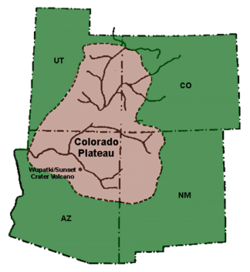
The Ute Mountain Ute Tribe are descendants of the Weeminuche band who moved to the Southern Ute reservation in 1897. Two thousand years ago, the Utes lived and ranged in the mountains and desert over much of the Colorado PlateauColorado Plateau
The Colorado Plateau, also called the Colorado Plateau Province, is a physiographic region of the Intermontane Plateaus, roughly centered on the Four Corners region of the southwestern United States. The province covers an area of 337,000 km2 within western Colorado, northwestern New Mexico,...
: much of present day eastern Utah
Utah
Utah is a state in the Western United States. It was the 45th state to join the Union, on January 4, 1896. Approximately 80% of Utah's 2,763,885 people live along the Wasatch Front, centering on Salt Lake City. This leaves vast expanses of the state nearly uninhabited, making the population the...
, western Colorado
Colorado
Colorado is a U.S. state that encompasses much of the Rocky Mountains as well as the northeastern portion of the Colorado Plateau and the western edge of the Great Plains...
, northern Arizona
Arizona
Arizona ; is a state located in the southwestern region of the United States. It is also part of the western United States and the mountain west. The capital and largest city is Phoenix...
and northwestern New Mexico
New Mexico
New Mexico is a state located in the southwest and western regions of the United States. New Mexico is also usually considered one of the Mountain States. With a population density of 16 per square mile, New Mexico is the sixth-most sparsely inhabited U.S...
. The use of lands in the Four Corners area, where the Ute Mountain Ute tribe now live, though, came later. Most anthropologists agree that Utes were established in the Four Corners area by 1500 A.D. The Ute people were hunters and gatherers
Hunter-gatherer
A hunter-gatherer or forage society is one in which most or all food is obtained from wild plants and animals, in contrast to agricultural societies which rely mainly on domesticated species. Hunting and gathering was the ancestral subsistence mode of Homo, and all modern humans were...
who moved on foot to hunting grounds and gathering land based upon the season. The men hunted animals, including deer, antelope, buffalo, rabbits, and other small mammals and birds. Women gathered grasses, nuts, berries, roots, and greens in woven baskets; They also processed and stored meat and plant materials for winter use. Ute in the western part of their territory lived in wickiups and ramadas; Hide tipi
Tipi
A tipi is a Lakota name for a conical tent traditionally made of animal skins and wooden poles used by the nomadic tribes and sedentary tribal dwellers of the Great Plains...
s were used in the eastern reaches of their territory.
As a result of American westward expansion, the Utes now possess only a small fraction of the land that they once traveled seasonally. The Ute people consist of three populations of people:
- Ute Indian Tribe of the Uintah and Ouray ReservationUte Indian Tribe of the Uintah and Ouray ReservationThe Ute Indian Tribe of the Uintah and Ouray Reservation is a federally recognized tribe of Ute Indians in Utah. The Uintah are a western band of Ute.-Government:The Uintah and Ouray Reservation headquarters is located in Fort Duchesne, Utah....
near Fort DuchesneFort Duchesne, UtahFort Duchesne is a census-designated place in Uintah County, Utah, United States. The population was 621 at the 2000 census, a slight decrease from the 1990 figure of 655...
in northeastern Utah. - The Southern UteSouthern Ute Indian ReservationThe Southern Ute Indian Reservation lies in southwestern Colorado, USA, along the northern border of New Mexico. Its territory consists of land from three counties; in descending order of surface area they are La Plata, Archuleta, and Montezuma Counties. The reservation has a land area of 1,058.785...
live on a reservation in southwestern Colorado near IgnacioIgnacio, ColoradoThe Town of Ignacio is a Statutory Town located in La Plata County, Colorado, United States. The population was 669 at the 2000 census.Located within the boundaries of the Southern Ute Indian Reservation, the town is the capital of the Southern Ute Indian tribe. It was named for their...
. - The Ute Mountain Ute Tribe headquartered in Towaoc, ColoradoTowaoc, ColoradoTowaoc is a census-designated place on the Ute Mountain Ute Tribe Reservation in Montezuma County, Colorado, United States. The population was 1,097 at the 2000 census. The Towaoc Post Office has the ZIP Code 81334....
, the subjects of this article.
Colonial Spain in America
The Mesa Verde region, the present day area of the Ute Mountain Ute Tribe reservation and the Mesa Verde National Park, was the northern most edge of the colonial territory of Spain. Initial exploration of the American Southwest by the Spanish occurred in 1540, but Spaniards didn't settle into present day New Mexico until 1598. They established their first capital near the pueblo of Ohkay OwingehOhkay Owingeh, New Mexico
Ohkay Owingeh is a pueblo and census designated place in Rio Arriba County, New Mexico, United States. Its elevation is and it is located at . One of its boundaries is contiguous with Española, about north of Santa Fe....
, which they renamed San Juan de los Caballeros.
In 1626 an account was taken of the Utes by a Spanish scribe in New Mexico. About 1640 the Utes began trading with the Spanish for horses. Spanish traders followed trails to Ute villages and Utes traveled to New Mexican towns. The Utes brought buckskin, dried meats, furs, and slaves to exchange for horses, knives, and blankets. Spanish officials negotiate the first peace treaty with the Utes in 1670. In search of gold, Juan de Rivera made three expeditions between 1761 and 1765 from Taos through southwestern Colorado to the Gunnison River. He did not return with gold, but did establish trade with Utes and other Native Americans along the Gunnison River.
On July 29,1776 two Franciscan
Franciscan
Most Franciscans are members of Roman Catholic religious orders founded by Saint Francis of Assisi. Besides Roman Catholic communities, there are also Old Catholic, Anglican, Lutheran, ecumenical and Non-denominational Franciscan communities....
priests, Francisco Atanasio Domínguez and Silvestre Vélez de Escalante and eight men left Santa Fe
Santa Fe, New Mexico
Santa Fe is the capital of the U.S. state of New Mexico. It is the fourth-largest city in the state and is the seat of . Santa Fe had a population of 67,947 in the 2010 census...
to conduct an expedition through Ute territory to find a route to Spanish missions in California
Spanish missions in California
The Spanish missions in California comprise a series of religious and military outposts established by Spanish Catholics of the Franciscan Order between 1769 and 1823 to spread the Christian faith among the local Native Americans. The missions represented the first major effort by Europeans to...
. They traveled through western Colorado
Colorado
Colorado is a U.S. state that encompasses much of the Rocky Mountains as well as the northeastern portion of the Colorado Plateau and the western edge of the Great Plains...
and Utah
Utah
Utah is a state in the Western United States. It was the 45th state to join the Union, on January 4, 1896. Approximately 80% of Utah's 2,763,885 people live along the Wasatch Front, centering on Salt Lake City. This leaves vast expanses of the state nearly uninhabited, making the population the...
, documenting the "lush, mountainous land filled with game and timber, strange ruins of stone cities and villages, and rivers showing signs of precious metals." Beset by hunger and illness, the men turned back at Salt Lake Valley
Salt Lake Valley
Salt Lake Valley is a valley in Salt Lake County in the north-central portion of the U.S. state of Utah. It contains Salt Lake City and many of its suburbs, notably West Valley City, Murray, Sandy, and West Jordan; its total population is 1,029,655 as of 2010...
and returned to Santa Fe. The maps and information provided from the expedition provided useful information for future travel and their route from Santa Fe to the Salt Lake Valley became known as the Old Spanish Trail
Old Spanish Trail (trade route)
The Old Spanish Trail is a historical trade route which connected the northern New Mexico settlements near or in Santa Fe, New Mexico with that of Los Angeles, California and southern California. Approximately long, it ran through areas of high mountains, arid deserts, and deep canyons. It is...
.
The Adams–Onís Treaty of 1819 established an official boundary line between Spanish and United States possessions in the southwest. Spanish territory included the southern plains, a large part of the western Rocky Mountains, and the entire western plateau region of Colorado. Even with the boundary, the Spanish did little to maintain their northern borders. When Mexico gained its independence from Spain, the Spanish lands became Mexican land.
American westward expansion
American fur trappers head into the western frontier in 1811 and encounter Utes. The Santa Fe TrailSanta Fe Trail
The Santa Fe Trail was a 19th-century transportation route through central North America that connected Missouri with Santa Fe, New Mexico. Pioneered in 1822 by William Becknell, it served as a vital commercial and military highway until the introduction of the railroad to Santa Fe in 1880...
is opened in 1821 by William Bucknell; passage of goods through Ute territory becomes common. William Bent
William Bent
William Wells Bent was a frontier trapper, trader, and rancher in the American West who mediated among the Cheyenne Nation, other Native American tribes and the expanding United States. With his brothers, Bent established a trade business along the Santa Fe Trail. In the early 1830s Bent built an...
and Ceran St. Vrain
Ceran St. Vrain
Ceran St. Vrain , also known as Ceran de Hault de Lassus de St. Vrain, was a major fur trader near Taos, New Mexico, where he and his partner William Bent established the trading post of Bent's Fort. St...
complete Bent's Fort
Bent's Old Fort National Historic Site
Bent's Old Fort is an 1833 fort located in Otero County in southeastern Colorado, USA. William and Charles Bent, along with Ceran St. Vrain, built the fort to trade with Southern Cheyenne and Arapaho Plains Indians and trappers for buffalo robes...
in 1834 on the Arkansas River
Arkansas River
The Arkansas River is a major tributary of the Mississippi River. The Arkansas generally flows to the east and southeast as it traverses the U.S. states of Colorado, Kansas, Oklahoma, and Arkansas. The river's initial basin starts in the Western United States in Colorado, specifically the Arkansas...
, a trading stop along the Santa Fe trail.
In 1848 the Treaty of Guadalupe Hidalgo
Treaty of Guadalupe Hidalgo
The Treaty of Guadalupe Hidalgo is the peace treaty, largely dictated by the United States to the interim government of a militarily occupied Mexico City, that ended the Mexican-American War on February 2, 1848...
ends the Mexican-American War and New Mexico and southern Colorado are ceded to the United States. The next year, the first United States treaty is made with Utes made at Abiquiú, New Mexico
Abiquiú, New Mexico
Abiquiú, or Abiquiu is a small unincorporated town located in Rio Arriba County, in northern New Mexico in the southwestern United States, about 53 miles north of Santa Fe. In the 1730s, it was the third largest settlement in the New Mexico Territory...
; Utes acknowledge United States authority and the United States agrees to pay the Utes $5,000 per year the keep the peace. Americans recruited Southern Utes to aid them in conflicts with the Navajos, which the Ute saw as an economic need. Ironically, in 1868 both the Navajo and Ute tribes were removed to reservations.
As more Americans moved into the western frontier, conflicts arose with the establishment of forts, reduction in land and access to ancient hunting and gathering grounds, and significant reduction in the Ute population from disease and malnutrition. In 1868 Utes are confined to western third of Colorado Territory
Colorado Territory
The Territory of Colorado was an organized incorporated territory of the United States that existed from February 28, 1861, until August 1, 1876, when it was admitted to the Union as the State of Colorado....
by treaty. In 1873 the gold and silver rush occurred in San Juan Mountains
San Juan Mountains
The San Juan Mountains are a high and rugged mountain range in the Rocky Mountains in southwestern Colorado. The area is highly mineralized and figured in the gold and silver mining industry of early Colorado. Major towns, all old mining camps, include Creede, Lake City, Silverton, Ouray, and...
; the Utes cede the San Juan mining area to the United States, it is one-fourth of their remaining lands. In the 1870s, Utes were pushed to the western part of the state of Colorado and held just a small portion of their land in Utah. Between 1859 and 1879 the Ute population fell from 8,000 to 2,000 due to disease and diminished hunting grounds.
In 1880, a year after the Meeker Massacre, a Ute delegation, including Chief Ouray
Chief Ouray
Ouray was a Native American chief of the Uncompahgre band of the Ute tribe, then located in western Colorado...
, went to Washington, D.C. to negotiate a treaty. In 1888 the United States takes more Ute lands, paying $50,000 to be divided among the Southern Utes. In 1895 the Hunter Act repeals 1888 treaties and establishes permanent reservation as outlined by 1880 treaties. The following year land allotments are distributed to Southern Utes. The tribe moved to the western end of the Southern Ute Reservation in 1897 (they were led by Chief Ignacio
Chief Ignacio
Chief Ignacio was a chief of the Weeminuche band of the Ute tribe of American Indians, also called the Southern Utes, located in present-day Colorado north of the San Juan River....
, for whom the eastern capital is named). In 1906 an agreement was made to trade Utes out of Mesa Verde National Park for land on Utah border. In 1905 the U.S. Government allotted new reservations with 80 to 160 acre plats for farming and access to communal grazing areas; This reduced the Ute land holdings by more than 85%, limited water access and limited the viability of successful livestock ranching. The remainder of the land was opened for white entry. In 1918 the Consolidated Ute Indian Reservation is established.
By 1934, a reservation is established in southwestern Colorado for Southern Utes, an arid, desolate strip of land 15 by 100 or 110 miles. In 1937 the Restoration Act returns 222,000 acres to Southern Utes. 30,000 acres were returned to Ute Mountain Utes in 1938. The U.S. Court of Claims awards the Confederated Bands of Colorado and Utah almost $32 million in 1950.
Tribal government
The Ute Mountain Utes adopt a constitution in 1940. In 1990 the tribe had 1,262 enrolled members.Reservation
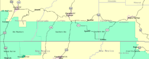
The Ute Mountain Ute Indian Reservation is located in southwestern ColoradoColorado
Colorado is a U.S. state that encompasses much of the Rocky Mountains as well as the northeastern portion of the Colorado Plateau and the western edge of the Great Plains...
and northwestern New Mexico
New Mexico
New Mexico is a state located in the southwest and western regions of the United States. New Mexico is also usually considered one of the Mountain States. With a population density of 16 per square mile, New Mexico is the sixth-most sparsely inhabited U.S...
consisting of 553,008 acres belonging to the Ute Mountain Ute Tribe, but held in trust by the U.S. Government. The reservation is located in the counties of Montezuma
Montezuma County, Colorado
Montezuma County is the southwesternmost of the 64 counties of the state of Colorado of the United States. The county population was 23,830 at U.S. Census 2000...
and La Plata
La Plata County, Colorado
La Plata County is the fourteenth most populous of the 64 counties of the State of Colorado of the United States. The county was named for the La Plata River and the La Plata Mountains. "La plata" is the Spanish language word for "silver". The United States Census Bureau estimated that the...
in Colorado and San Juan County, New Mexico
San Juan County, New Mexico
-2010:Whereas according to the 2010 U.S. Census Bureau:*51.6% White*0.6% Black*36.6% Native American*0.4% Asian*0.1% Native Hawaiian or Pacific Islander*3.5% Two or more races*7.2% Other races*19.1% Hispanic or Latino -2000:...
. There are also individually owned lands at Allen Canyon and White Mesa totally 8,499 acres, and 40 acres of school property, in San Juan County, Utah. Most of the people on the reservation live in the town of Towaoc
Towaoc, Colorado
Towaoc is a census-designated place on the Ute Mountain Ute Tribe Reservation in Montezuma County, Colorado, United States. The population was 1,097 at the 2000 census. The Towaoc Post Office has the ZIP Code 81334....
which is the also the site of the Ute Mountain Indian Agency.
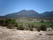
The elevation of the reservation varies from about 4,600 feet along the San Juan River near Four Corners to about 9,977 feet at the peak of the Ute Mountain
Ute Mountain
Ute Mountain , is a peak within the Ute Mountains, a small mountain range in the southwestern corner of Colorado. It is on the northern edge of the Ute Mountain Ute Reservation. The Reservation forms the southwestern corner of the state and of Montezuma County.Nomenclature for this peak and its...
. The reservation lands consist of Sleeping Ute Mountain
Ute Mountain
Ute Mountain , is a peak within the Ute Mountains, a small mountain range in the southwestern corner of Colorado. It is on the northern edge of the Ute Mountain Ute Reservation. The Reservation forms the southwestern corner of the state and of Montezuma County.Nomenclature for this peak and its...
, the Mancos River
Mancos River
Mancos River is an tributary of the San Juan River. It flows from the confluence of West Mancos River and East Mancos River near Mancos, Colorado and joins the San Juan near Four Corners Monument in New Mexico.-See also:*List of rivers of Colorado...
and canyons, a high mesas and semi-desert grassland. U.S. Highways 160 and 666 and State Highways 41 and 789 cross the reservation. In addition, there are two maintained gravel roads, one that follows the Mancos River
Mancos River
Mancos River is an tributary of the San Juan River. It flows from the confluence of West Mancos River and East Mancos River near Mancos, Colorado and joins the San Juan near Four Corners Monument in New Mexico.-See also:*List of rivers of Colorado...
Canyon and another from Towaoc to the Cache oilfield and Aneth, Utah
Aneth, Utah
Aneth is a census-designated place in San Juan County, Utah, United States. The population was 598 at the 2000 census.-Geography:Aneth is located at ....
, and off-road trails.
The population was 1,687 as of the 2000 census
United States Census, 2000
The Twenty-second United States Census, known as Census 2000 and conducted by the Census Bureau, determined the resident population of the United States on April 1, 2000, to be 281,421,906, an increase of 13.2% over the 248,709,873 persons enumerated during the 1990 Census...
.
Ute Mountain Tribal Park
The Ute Mountain Tribal Park, part of the Ute Mountain Ute Indian Reservation, is approximately 125,000 acres of land along the Mancos River. Hundreds of surface sites, cliff dwellings, petroglyphs and wall paintings of Ancestral Puebloan and Ute cultures are preserved in the park. Native American Ute tour guides provide background information about the people, culture and history who lived in the park lands. National Geographic Traveler chose it as one of "80 World Destinations for Travel in the 21st Century", one of only 9 places selected in the United States.Notable people
In 1880 Chief Ouray went to Washington, D.C. as part of the Ute delegation to negotiate a treaty. He made it to Washington, but died that year at 47 years of age. Chief Jack HouseChief Jack House
Chief Jack House was the last traditional, hereditary leader of the Ute Mountain Ute Tribe of Colorado. His grandson, Ernest House Sr., was later elected to serve as the Chairman of the Ute Mountain Ute Tribe for four, nonconsecutive four year terms in office from 1982 to 2010.-References:...
, the last traditional chief of the Utes, died in 1971.
See also
- Ute people
- Southern Ute Indian ReservationSouthern Ute Indian ReservationThe Southern Ute Indian Reservation lies in southwestern Colorado, USA, along the northern border of New Mexico. Its territory consists of land from three counties; in descending order of surface area they are La Plata, Archuleta, and Montezuma Counties. The reservation has a land area of 1,058.785...
of southwestern Colorado, east of Ute Mountain Ute Indian Reservation - Uintah and Ouray Indian ReservationUintah and Ouray Indian ReservationThe Uintah and Ouray Indian Reservation is located in northeastern Utah, USA. It is the homeland of the Northern Ute Tribe, and is the largest of three Indian reservations inhabited by members of the Ute Tribe of Native Americans. It lies in parts of seven counties; in descending order of land area...
of northeastern Utah, the homeland of the Northern Ute Tribe.
External links
- Ute Mountain Ute Tribe, official website
- Ute Mountain Tribal Park