
False Pass, Alaska
Encyclopedia
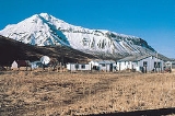
False Pass is a city in Aleutians East Borough, Alaska
, United States. Isanax̂ (variously spelled Issannakh, Isanak etc.) is the Aleut name for present day Isanotski Strait and means gap, hole, rent, or tear in the Aleut language which was rendered as Isanotski (or Issanakskie, Isanotskoi, Isanakh etc.) in transliterated Russian. The strait appears as Исанакъ in 1802 and Исаноцкый in 1844 on Russian maps. Isanotski Strait lies between the tip of the Alaska Peninsula and Unimak Island, the first of the Aleutian Islands and it connects the northern Gulf of Alaska with the Bering Sea. This strait was used for safe passage for millennia by Aleuts and later by the Russians during their occupation of the area. The strait is used today by most vessels less than 200 feet in length traveling to and from northern Alaska and points in southwest and southeast Alaska and the "lower 48" states.
False Pass is an early English name for Isanotski Strait on which the City of False Pass is located. The strait was called "False Pass" by early American sailing ship captains because it was thought to be impassable for their deep draft vessels at the northern end. A salmon cannery was built on the Unimak Island side of the strait in 1919 which provided the nucleus for the modern settlement. A U.S. post office with the name of False Pass was established in 1921 which gave official status to the community. Commercial fishing for salmon, cod, halibut and crab continues to be the core of the community's lifestyle and economy. The city population was 64 at the 2000 census.
, in the Aleutian Islands chain. Part of the city (26.093 km², or 10.075 sq mi) is actually on the westernmost tip of the mainland Alaska Peninsula
, across the Isanotski Strait (about 600 meters at the closest point), although that section is nearly unpopulated. The city boundaries include the abandoned villages of Morzhovoi and Ikatan.
According to the U.S. Census Bureau, the city has a total area of 68.3 square miles (176.9 km²), of which, 26.9 square miles (69.7 km²) of it is land and 41.4 square miles (107.2 km²) of it (60.63%) is water.
, 26.56% White
, 1.56% from other races
, and 9.38% from two or more races. 1.56% of the population were Hispanic
or Latino
of any race.
There were 22 households out of which 31.8% had children under the age of 18 living with them, 22.7% were married couples living together, 18.2% had a female householder with no husband present, and 36.4% were non-families. 31.8% of all households were made up of individuals and 9.1% had someone living alone who was 65 years of age or older. The average household size was 2.91 and the average family size was 3.79.
In the city the age distribution of the population shows 35.9% under the age of 18, 9.4% from 18 to 24, 18.8% from 25 to 44, 31.3% from 45 to 64, and 4.7% who were 65 years of age or older. The median age was 32 years. For every 100 females there were 100.0 males. For every 100 females age 18 and over, there were 115.8 males.
The median income for a household in the city was $49,375, and the median income for a family was $70,625. Males had a median income of $23,750 versus $37,083 for females. The per capita income
for the city was $21,465. There were 11.1% of families and 8.0% of the population living below the poverty line, including no under eighteens and 50.0% of those over 64.
Occupation categories for the 2000 census are shown in the accompanying pie chart. The community has traditionally depended upon commercial fishing, but it now employs only 24% of the workforce or 10 individuals. These individuals are boat captains and crewmen. As in many modern American communities, white collar sales/office and management positions now employ 51% of the employment positions or 21 people.
.
Aleutians East Borough, Alaska
- See also :*List of airports in the Aleutians East Borough*National Register of Historic Places listings in Aleutians East Borough, Alaska-External links:*-References:...
, United States. Isanax̂ (variously spelled Issannakh, Isanak etc.) is the Aleut name for present day Isanotski Strait and means gap, hole, rent, or tear in the Aleut language which was rendered as Isanotski (or Issanakskie, Isanotskoi, Isanakh etc.) in transliterated Russian. The strait appears as Исанакъ in 1802 and Исаноцкый in 1844 on Russian maps. Isanotski Strait lies between the tip of the Alaska Peninsula and Unimak Island, the first of the Aleutian Islands and it connects the northern Gulf of Alaska with the Bering Sea. This strait was used for safe passage for millennia by Aleuts and later by the Russians during their occupation of the area. The strait is used today by most vessels less than 200 feet in length traveling to and from northern Alaska and points in southwest and southeast Alaska and the "lower 48" states.
False Pass is an early English name for Isanotski Strait on which the City of False Pass is located. The strait was called "False Pass" by early American sailing ship captains because it was thought to be impassable for their deep draft vessels at the northern end. A salmon cannery was built on the Unimak Island side of the strait in 1919 which provided the nucleus for the modern settlement. A U.S. post office with the name of False Pass was established in 1921 which gave official status to the community. Commercial fishing for salmon, cod, halibut and crab continues to be the core of the community's lifestyle and economy. The city population was 64 at the 2000 census.
Geography
False Pass is located at 54°49′40"N 163°23′57"W (54.827886, -163.399090). It is near the eastern end of Unimak IslandUnimak Island
Unimak Island is the largest island in the Aleutian Islands chain of the U.S. state of Alaska. It is the easternmost island in the Aleutians and, with an area of 1,571.41 mi² , the ninth largest island in the United States and the 134th largest island in the world. It is home to Mount...
, in the Aleutian Islands chain. Part of the city (26.093 km², or 10.075 sq mi) is actually on the westernmost tip of the mainland Alaska Peninsula
Alaska Peninsula
The Alaska Peninsula is a peninsula extending about to the southwest from the mainland of Alaska and ending in the Aleutian Islands. The peninsula separates the Pacific Ocean from Bristol Bay, an arm of the Bering Sea....
, across the Isanotski Strait (about 600 meters at the closest point), although that section is nearly unpopulated. The city boundaries include the abandoned villages of Morzhovoi and Ikatan.
According to the U.S. Census Bureau, the city has a total area of 68.3 square miles (176.9 km²), of which, 26.9 square miles (69.7 km²) of it is land and 41.4 square miles (107.2 km²) of it (60.63%) is water.
2000 Census
As of the census of 2000, there were 64 people, 22 households, and 13 families residing in the city. The population density was 2.4 people per square mile (0.9/km²). There were 40 housing units at an average density of 1.5 per square mile (0.6/km²). The racial makeup of the city was 62.50% Native AmericanRace (United States Census)
Race and ethnicity in the United States Census, as defined by the Federal Office of Management and Budget and the United States Census Bureau, are self-identification data items in which residents choose the race or races with which they most closely identify, and indicate whether or not they are...
, 26.56% White
Race (United States Census)
Race and ethnicity in the United States Census, as defined by the Federal Office of Management and Budget and the United States Census Bureau, are self-identification data items in which residents choose the race or races with which they most closely identify, and indicate whether or not they are...
, 1.56% from other races
Race (United States Census)
Race and ethnicity in the United States Census, as defined by the Federal Office of Management and Budget and the United States Census Bureau, are self-identification data items in which residents choose the race or races with which they most closely identify, and indicate whether or not they are...
, and 9.38% from two or more races. 1.56% of the population were Hispanic
Race (United States Census)
Race and ethnicity in the United States Census, as defined by the Federal Office of Management and Budget and the United States Census Bureau, are self-identification data items in which residents choose the race or races with which they most closely identify, and indicate whether or not they are...
or Latino
Race (United States Census)
Race and ethnicity in the United States Census, as defined by the Federal Office of Management and Budget and the United States Census Bureau, are self-identification data items in which residents choose the race or races with which they most closely identify, and indicate whether or not they are...
of any race.
There were 22 households out of which 31.8% had children under the age of 18 living with them, 22.7% were married couples living together, 18.2% had a female householder with no husband present, and 36.4% were non-families. 31.8% of all households were made up of individuals and 9.1% had someone living alone who was 65 years of age or older. The average household size was 2.91 and the average family size was 3.79.
In the city the age distribution of the population shows 35.9% under the age of 18, 9.4% from 18 to 24, 18.8% from 25 to 44, 31.3% from 45 to 64, and 4.7% who were 65 years of age or older. The median age was 32 years. For every 100 females there were 100.0 males. For every 100 females age 18 and over, there were 115.8 males.
The median income for a household in the city was $49,375, and the median income for a family was $70,625. Males had a median income of $23,750 versus $37,083 for females. The per capita income
Per capita income
Per capita income or income per person is a measure of mean income within an economic aggregate, such as a country or city. It is calculated by taking a measure of all sources of income in the aggregate and dividing it by the total population...
for the city was $21,465. There were 11.1% of families and 8.0% of the population living below the poverty line, including no under eighteens and 50.0% of those over 64.
Occupation categories for the 2000 census are shown in the accompanying pie chart. The community has traditionally depended upon commercial fishing, but it now employs only 24% of the workforce or 10 individuals. These individuals are boat captains and crewmen. As in many modern American communities, white collar sales/office and management positions now employ 51% of the employment positions or 21 people.
Transportation
Boats and aircraft are the only way to get to False Pass. Aircraft use False Pass AirportFalse Pass Airport
False Pass Airport is a state-owned public-use airport located in False Pass, a city in the Aleutians East Borough of the U.S. state of Alaska. Scheduled airline service to Cold Bay Airport is provided by Peninsula Airways ....
.