
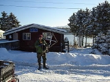
Port Lions, Alaska
Encyclopedia
Port Lions is a city located on Kodiak Island
in the Kodiak Island Borough
of the U.S. state of Alaska
. As of the 2000 census
, the population of the city was 256.
Port Lions was built to house the inhabitants of Ag'waneq
from the neighboring island of Afognak
and Port Wakefield
from Raspberry Island
, after their villages were destroyed by the Good Friday Earthquake
in 1964. Port Lions was built with help from the United States government and the Lions Club
. It was named in honor of the club.
According to the United States Census Bureau
, the city has a total area of 10.1 square miles (26.2 km²), of which, 6.3 square miles (16.3 km²) of it is land and 3.7 square miles (9.6 km²) of it (36.98%) is water.
, 63.28% Native American
, and 1.95% from two or more races. 1.95% of the population were Hispanic
or Latino
of any race.
There were 89 households out of which 44.9% had children under the age of 18 living with them, 74.2% were married couples living together, 7.9% had a female householder with no husband present, and 14.6% were non-families. 13.5% of all households were made up of individuals and 4.5% had someone living alone who was 65 years of age or older. The average household size was 2.88 and the average family size was 3.11.
In the city the age distribution of the population shows 33.2% under the age of 18, 3.9% from 18 to 24, 29.7% from 25 to 44, 26.2% from 45 to 64, and 7.0% who were 65 years of age or older. The median age was 36 years. For every 100 females there were 113.3 males. For every 100 females age 18 and over, there were 106.0 males.
The median income for a household in the city was $39,107, and the median income for a family was $42,656. Males had a median income of $41,250 versus $30,625 for females. The per capita income
for the city was $17,492. About 12.7% of families and 12.1% of the population were below the poverty line, including 15.0% of those under the age of eighteen and 10.7% of those sixty five or over.
operates a remote scientific radio receiver in Port Lions to study very low frequency
radio signals.
Kodiak Island
Kodiak Island is a large island on the south coast of the U.S. state of Alaska, separated from the Alaska mainland by the Shelikof Strait. The largest island in the Kodiak Archipelago, Kodiak Island is the second largest island in the United States and the 80th largest island in the world, with an...
in the Kodiak Island Borough
Kodiak Island Borough, Alaska
-National protected areas:* Alaska Maritime National Wildlife Refuge ** Barren Islands** Semidi Wilderness*** Semidi Islands** Trinity Islands*** Sitkinak Island*** Tugidak Island...
of the U.S. state of Alaska
Alaska
Alaska is the largest state in the United States by area. It is situated in the northwest extremity of the North American continent, with Canada to the east, the Arctic Ocean to the north, and the Pacific Ocean to the west and south, with Russia further west across the Bering Strait...
. As of the 2000 census
United States Census, 2000
The Twenty-second United States Census, known as Census 2000 and conducted by the Census Bureau, determined the resident population of the United States on April 1, 2000, to be 281,421,906, an increase of 13.2% over the 248,709,873 persons enumerated during the 1990 Census...
, the population of the city was 256.
Port Lions was built to house the inhabitants of Ag'waneq
Afognak, Alaska
Afognak was an Alutiiq village on the island of Afognak in Kodiak Island Borough, Alaska, United States. It was located on Afognak Bay on the southwest coast of the island, north of Kodiak Island.- History :...
from the neighboring island of Afognak
Afognak
Afognak is an island north of Kodiak Island in the U.S. state of Alaska. It is 43 miles from east to west and 23 miles from north to south and has a land area of , making it the 18th largest island in the United States. The coast is split by many long, narrow bays...
and Port Wakefield
Port Wakefield, Alaska
Port Wakefield, Alaska is a ghost town on the north-east coat of Raspberry Island in the Kodiak Archipelago located in the Gulf of Alaska.It was established shortly after World War II by Lowell A...
from Raspberry Island
Raspberry Island (Alaska)
Raspberry Island is an island of the Kodiak Archipelago located in the Gulf of Alaska in the U.S. state of Alaska. It is located two miles northwest of Whale Island, and just across the mile wide Raspberry Strait from the southwestern end of Afognak. The island is separated from Kodiak Island by...
, after their villages were destroyed by the Good Friday Earthquake
Good Friday Earthquake
The 1964 Alaska earthquake, also known as the Great Alaskan Earthquake, the Portage Earthquake and the Good Friday Earthquake, was a megathrust earthquake that began at 5:36 P.M. AST on Good Friday, March 27, 1964...
in 1964. Port Lions was built with help from the United States government and the Lions Club
Lions Clubs International
Lions Clubs International is a secular service organization with over 44,500 clubs and more than 1,368,683 members in 191 countries around the world founded by Melvin Jones Headquartered in Oak Brook, Illinois, United States, the organization aims to meet the needs of communities on a local and...
. It was named in honor of the club.
Geography
Port Lions is located at 57°52′5"N 152°52′48"W (57.868070, -152.880047).According to the United States Census Bureau
United States Census Bureau
The United States Census Bureau is the government agency that is responsible for the United States Census. It also gathers other national demographic and economic data...
, the city has a total area of 10.1 square miles (26.2 km²), of which, 6.3 square miles (16.3 km²) of it is land and 3.7 square miles (9.6 km²) of it (36.98%) is water.
Demographics
As of the census of 2000, there were 256 people, 89 households, and 76 families residing in the city. The population density was 40.3 people per square mile (15.6/km²). There were 106 housing units at an average density of 16.7 per square mile (6.4/km²). The racial makeup of the city was 34.77% WhiteRace (United States Census)
Race and ethnicity in the United States Census, as defined by the Federal Office of Management and Budget and the United States Census Bureau, are self-identification data items in which residents choose the race or races with which they most closely identify, and indicate whether or not they are...
, 63.28% Native American
Race (United States Census)
Race and ethnicity in the United States Census, as defined by the Federal Office of Management and Budget and the United States Census Bureau, are self-identification data items in which residents choose the race or races with which they most closely identify, and indicate whether or not they are...
, and 1.95% from two or more races. 1.95% of the population were Hispanic
Race (United States Census)
Race and ethnicity in the United States Census, as defined by the Federal Office of Management and Budget and the United States Census Bureau, are self-identification data items in which residents choose the race or races with which they most closely identify, and indicate whether or not they are...
or Latino
Race (United States Census)
Race and ethnicity in the United States Census, as defined by the Federal Office of Management and Budget and the United States Census Bureau, are self-identification data items in which residents choose the race or races with which they most closely identify, and indicate whether or not they are...
of any race.
There were 89 households out of which 44.9% had children under the age of 18 living with them, 74.2% were married couples living together, 7.9% had a female householder with no husband present, and 14.6% were non-families. 13.5% of all households were made up of individuals and 4.5% had someone living alone who was 65 years of age or older. The average household size was 2.88 and the average family size was 3.11.
In the city the age distribution of the population shows 33.2% under the age of 18, 3.9% from 18 to 24, 29.7% from 25 to 44, 26.2% from 45 to 64, and 7.0% who were 65 years of age or older. The median age was 36 years. For every 100 females there were 113.3 males. For every 100 females age 18 and over, there were 106.0 males.
The median income for a household in the city was $39,107, and the median income for a family was $42,656. Males had a median income of $41,250 versus $30,625 for females. The per capita income
Per capita income
Per capita income or income per person is a measure of mean income within an economic aggregate, such as a country or city. It is calculated by taking a measure of all sources of income in the aggregate and dividing it by the total population...
for the city was $17,492. About 12.7% of families and 12.1% of the population were below the poverty line, including 15.0% of those under the age of eighteen and 10.7% of those sixty five or over.
Communications
Stanford UniversityStanford University
The Leland Stanford Junior University, commonly referred to as Stanford University or Stanford, is a private research university on an campus located near Palo Alto, California. It is situated in the northwestern Santa Clara Valley on the San Francisco Peninsula, approximately northwest of San...
operates a remote scientific radio receiver in Port Lions to study very low frequency
Very low frequency
225px|thumb|right|A VLF receiving antenna at [[Palmer Station]], Antarctica, operated by Stanford UniversityVery low frequency or VLF refers to radio frequencies in the range of 3 kHz to 30 kHz. Since there is not much bandwidth in this band of the radio spectrum, only the very simplest signals...
radio signals.