
Puna, Hawaii
Encyclopedia
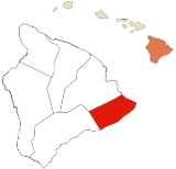
Puna is one of the nine districts in Hawaii County
, Big Island
, Hawaii
. The District of Puna is located on the easternmost portion of the island and shares borders to the north with the District of South Hilo and a border to the west with the District of Kaū
. With its size of just under 320000 acres (1,295 km²), Puna is slightly smaller than the island of Kauai
.
Summary=
In the Hawaiian language, puna can mean a spring (of water) and is also the name of the district. The shoreline of the Big Island is famous for its percolating spring water and along the coast in Puna there are several tide pools where one can experience the cold spring water bubbling up from the ground.
The eastern flank of Kīlauea
lies completely within the District of Puna. Most terrain in Puna contains gradual slopes, (usually less than 15 degrees in angle/7.5% grade), which increase in elevation towards the summit of Kīlauea
at the western point of the District.
Due to the porosity of the volcanic rock and the relative scarcity of any deep soil, there are no permanently running streams or waterways in the district of Puna. However, there are several intermittent streams which flow during periods of heavy rain. These streams usually disappear within several hours of the heavy precipitation. There is also an extensive network of subterranean lava tubes throughout much of the District of Puna which are sometimes accessible through collapsed openings.
Puna contains nearly 45% of Hawaii County's total subdivided lots, a low build-out percentage, and the highest growth rate, all on a landscape that is exposed to the highest risk of volcanic and seismic activity.
Agricultural tourism is emerging as part of a mix of attractions drawing more visitors to Puna. With the renewal of native Hawaiian culture and an appreciation for nature, Puna has established itself as a premier natural and cultural attraction, with Hawaii Volcanoes National Park
as a main draw.
Puna has a high percentage of lower-income residents, and the District of Puna is regarded as a place of opportunity for affordable housing. Many of the subdivision lots offer some of the lowest price home sites in Hawaii for owner-built housing. Approximately 85 percent of Hawaii Island's Section 8
low-income rental housing certificate holders are Puna residents. Nevertheless, there are still many residents without adequate housing. Opportunities for retaining and expanding the stock of affordable housing are narrowing as land values rise in Puna and government housing subsidies shrink.
Introduction=
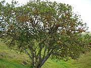
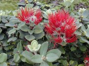 Puna's natural environment is dominated by volcanic activity, unique geological events and formations, and a variety of plant communities that provide habitat for native species. Eruptions of Kīlauea and the nearby volcano Mauna Loa continue to shape the ecology of the region, and even the land itself. Rainfall is higher on the windward slopes of Kīlauea, while the leeward slopes, extending into Kau, are relatively arid. The wetter side is covered by thick forests of ōhia lehua trees and hāpuu tree ferns on all but the youngest of lava flows or cleared land. On the drier side, vegetation is more open, exposing the underlying geology.
A distinguishing feature of Puna's native forest is its interaction with repeated, relatively recent lava flows, creating varied ages of forests underlain by different compositions of lava flows, ash and explosion deposits. This, in turn, enriches biodiversity, especially in older stands of forest, known as kīpuka
, that have been isolated by younger lava flows.
Some of the native animal and plant species present in Puna are endemic to Hawaii, found nowhere else in the world. In addition, Puna harbors many other native species, such as
the Pueo
(Hawaiian Owl), the Amakihi, the Apapane, and various insects, some of which are rare.
Puna's unique lava tube caves are a notable geological feature and popular attraction. Kazumura Cave
is recognized as the world's longest lava cave at nearly 40 miles (64.4 km). The lava caves are also important as natural habitats for endemic cave-adapted species of insects and invertebrates. In addition, some of caves were used by ancient Hawaiians as burial sites for Alii
(royalty) and others.
Puna's geology and biological resources inspired reverence for the landscape by the original human inhabitants of Hawaii. By cultural tradition, Kīlauea is the home of the goddess Pele, giving the volcano and its surroundings a sacred status. Ancient Hawaiians recognized Puna as the land of Pele, with human habitation subject to Pele's will. Makaainana, or commoners, were free to relocate to other ahupuaa
(the lands of another chief) when Pele reasserted her dominion over the land. A map dated from 1826 indicates 24 ahupuaa located around the entire coast of Puna. While human settlement from ancient times was concentrated in a wide band of habitation within about 3 miles (5 km) of the shoreline, areas near the volcano and upper reaches of forest were visited for gathering as well as spiritual purposes.
Hilo and Kau are linked both geographically and historically through Puna. Prior to the arrival of western civilization there were routes which connected these two very different areas of the island through Puna. Many of the ancient trails, which are still protected as public land or with traditional access rights, connect areas of natural beauty that have cultural significance. Even though the 19th and 20th centuries brought rapid physical and cultural changes, some of the trails lead to remote spots that are important for traditional gathering and other cultural practices. The areas they traverse include some stands of fairly intact native vegetation with little modern development, offering a glimpse into the past.
Climate & Weather=
Climate in Puna varies with location (windward and leeward), and elevation (from sea level to over 4,000 feet). On the windward side, (the northern facing slopes of Kīlauea
), rainfall is generally abundant (80 inches - 200 inches/year) with most of the rain falling around the 2,000 to 3000 ft (914.4 m) elevation (averaging above 140 inches/year in this elevation). On the leeward side, the southern facing slopes of the eastern rift of Kīlauea, there is significantly less rainfall (usually 40-80 inches). This reduced rainfall and cloud cover means there is a greater amount of direct sunlight received in the leeward areas than in the windward areas.
The climate along the coastal areas from sea level to about 500 feet (152.4 m) in elevation tends to be a mild tropical climate with fairly significant amounts of rain and milder temperatures. Rainfall amounts increase significantly on the windward facing slopes as one increases in elevation, with average rainfall amounts peaking at the 2800 feet (853.4 m) elevation, (near Glenwood). Noticeable cooling from sea level temperatures begins at around 1000 feet (304.8 m) with temperatures decreasing as one increases elevation, towards the summit of Kīlauea. The coolest temperatures in Puna tend to be near Volcano Village, which is around 4000 feet (1,219.2 m) in elevation.
Trade winds, which blow from the northeast to the southwest, are the common wind throughout most days on the windward side of Puna. In the evenings, cooler air from the slopes of Mauna Loa
sinks down toward Puna and this phenomenon causes air colder than normal to come down into Puna, dropping temperatures as much as 25°F overnight from the temperature at sunset.
Several locations flood during periods of heavy rainfall throughout Puna. Flooding in Puna is short lived, due to the high porosity of the volcanic rock and the lack of any significant soil to retain or hold the water. The lava flows on the slopes of Kīlauea are the newest on the island and therefore the amount of soil in this area is significantly reduced compared to other areas of the island which are much older. The slopes on Kīlauea have not had the time needed to erode yet and to form regularly running streams.
 Extensive tracts of Puna's landscape were transformed when Western contact brought large scale resource exploitation and agriculture in successive waves. Sandalwood
export began in 1790, reaching its peak between 1810 and 1825. After Hawaii's first forestry law in 1839 restricted the removal of sandalwood trees, cattle ranching and coffee
cultivation became the leading commercial activities. By 1850, agriculture diversified with the cultivation of potatoes, onions, pumpkins, oranges
, and molasses
.
 Before 1900, coffee
was the chief agricultural crop in the area. Over 6000 acre of coffee trees were owned by approximately 200 independent coffee planters and 6 incorporated companies.
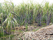
In 1899, the Olaa Sugar Company was founded. The coffee trees were uprooted to make way for sugarcane
. Ōhia forests also had to be cleared, field rock piled, land plowed by mules or dug up by hand with a pick. Sugarcane was in large-scale production. In 1960, the company would be renamed the Puna Sugar Company due to a jinxed feeling of the name Olaa. The sugar mill operation ran for just over 80 years, until 1984. The plantation fields extended for 10 miles (16.1 km) along both sides of Highway 11 between Keaau and Mountain View (from sea level to 2,200 feet), as well as in the Pāhoa and Kapoho areas.
Within the last 15 years, some farmers began farming coffee again in the District of Puna, primarily in the Hawaiian Acres subdivision. Coffee has become an increasingly popular product to grow in Puna and some people seem to prefer Puna coffee over other Hawaiian coffee. Whether Puna coffee will return to the significant size of the 19th century has yet to be determined.
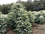
 Macadamia
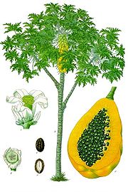
nuts and papaya
were introduced in 1881 and 1919 respectively. Since the closure of the Puna Sugar Company in 1991, papaya and macadamia nut production have become the leading cash crops of Puna, (along with cannabis
). About 97% of the state's papaya production occurs in Puna, primarily in the Kapoho area. The closure of sugar production in Puna potentially opened a large amount of agriculture land to a more diversified industry, although much of the former plantation land lies unused and covered predominantly by non-native trees, shrubs and grasses.
Mauna Loa Macadamia Nut Corporation
has been running their macadamia growing operation out of Keaau continuously since 1948, with their first harvest in 1956. Their operation has grown to almost 10000 acres (40 km²) of orchards on the slopes of the Mauna Loa
volcano on the Big Island of Hawaii, on the Puna side of the border with the South Hilo district, just outside of Hilo town. This is also the location of the primary nut processing plant for the Mauna Loa Macadamia Nut Corporation
which is now owned by The Hershey Company
.
Volcano area are suitable for growing crops that cannot thrive in many other areas of Hawaii. Even the wettest of areas have produced well under greenhouse cover. Also, due to volcanic activity, the age of the soils varies considerably throughout Puna, with corresponding variations in inherent natural fertility and tendency to resist weeds.
The cut flower industry
is a large part of the agricultural market in Puna. Orchids and anthuriums, some which are very rare, are the bulk of the cut flower market. Many types of agricultural products are sent out every day from Puna, via FedEx
at Hilo International Airport
, to customers all around the world.
Water Bottling=
Hawaiian Springs has their headquarters and main bottling plant located in Keaau. The water is artesian
, bottled at the source; pumped directly from the aquifer to the bottling facility. It is 100% natural water bottled in Hawaii at the source, which distinguishes it from other "purified drinking water" or "filtered tap water" bottled in Hawaii and elsewhere around the world. Hawaiian Springs natural artesian water is distributed throughout Hawaii, and is now available in select US mainland and international markets.
Residential Living in Puna=
The recent pattern of residential development and population growth in Puna is the result of widespread land subdivision within the past half century. Between 1958 and 1973, more than 52,500 subdivision lots were created. Since that time, nearly 2,500 of these lots have been covered by lava flows or have been rendered unbuildable by shoreline subsidence, reflecting the risks of building on a landscape subject to volcanic and seismic hazards. Moreover, most subdivision lots are accessed by private, unpaved roads. The streets generally lack sidewalks and lighting, and do not meet current Hawaii County standards in terms of pavement width, vertical geometrics, drainage and other design parameters. None of the subdivisions have central sewer systems and only a couple have private water systems. Most lots rely on individual water catchment systems supplemented with private delivery trucks for potable water. Large sections of some subdivisions are off the power grid.
Despite the natural hazards and rudimentary infrastructure and services in these subdivisions, build-out of the lots has been occurring, especially within the northeast quadrant of Puna (from Keaau to Pāhoa) and in the vicinity of Volcano where the highest rates of population growth have been occurring. Puna is experiencing the fastest rate of growth of all the districts in the County of Hawaii. The U.S. Census population count in 2000 for Puna was 27,232. The 2010 U.S. Census results shows the population in Puna to now be 45,326, an increase of 66% in 10 years. By 2030, the population is projected to grow to approximately 75,000. Since only about one-quarter of the available lots have been developed at present, it is clear that these extensive subdivisions present formidable challenges to the natural environment and the rational management of development for future population growth.
While much of the natural environment and some of the cultural heritage of these areas has been altered and compromised, effective and timely intervention can do much to prevent further degradation and possibly even restore some of what has been lost or undergoing change.
, but there are many other sites throughout the district that have been identified as having historic significance.
Puna's coastal areas have relatively dense concentrations of historical, cultural, and burial sites. Burial sites and cultural artifacts are not uncommon on subdivision lots, although many
are hidden in lava tubes, making them susceptible to destruction due to grading. While the State Historic Preservation Division (SHPD) plays a role in reviewing construction permits, Hawaii State law requires that construction activity be halted in the event of discovery of archaeological remains.
Puna's history is also evident in the architecture of its older towns and villages; namely, Keaau, the Kurtistown-Mountain View corridor, Pāhoa, and Volcano. Each of these places has a distinctive design character that reflects its history and location. Volcano presently has a small, legally recognized historic district, but otherwise there are no special design controls to preserve the design character of these towns.
Scenic natural settings are numerous in Puna, but they are, for the most part, protected by existing land use controls or public land agencies. Trails and scenic byways deserve special mention, since they are continuous visual experiences along a designated corridor and are particularly vulnerable to loss.
Puna Healthcare=
There are no hospital facilities in the District of Puna. With a growing population, Puna needs more social and health care services within the District of Puna boundaries. Yet, there are two major challenges to making them accessible to residents:
Public Safety & Sanitation Services in Puna=
Public safety and sanitation services in Puna have needed to adapt to the widely dispersed settlement pattern in the District of Puna and the poor road conditions throughout most of the subdivisions. It is neither cost-efficient nor practical for the County of Hawaii to provide a sufficient number of police, fire and paramedical facilities with associated staffing and equipment to provide coverage to all populated areas with the response times that are typical of urban or most suburban areas. Therefore, County services are supplemented with community policing programs and volunteer fire stations, usually with at least some degree of County assistance in the form of training, equipment and/or personnel.
There are no public wastewater treatment systems in Puna. Similarly, there is no municipal house-to-house solid waste collection service. Most homes have a cesspool for wastewater which goes directly into the ground. The County provides solid waste transfer stations located in Pāhoa, Glenwood, Volcano, Kalapana, and Keaau. Until recently, all solid waste was disposed in landfills. Following previous upgrades to the Keaau solid waste transfer station the County upgraded the Pāhoa, Glenwood, and Volcano facilities in late 2007 to support recycling, including an improved redemption center for bottles and cans, collection bins for scrap metal, mixed recyclables, and green waste.
A new fire station was recently opened in 2010 just outside of Pāhoa on Highway 130. A new police station is currently under construction directly adjacent to the fire station and should be completed some time in 2011.
Parks & recreation in Puna=
Puna contains most of Hawaii Volcanoes National Park
, which is the premier nature park in the Hawaiian Islands
, (although the actual entrance to the park is located in the District of Kau). Added to the inventory of nature parks are the State-owned: MacKenzie State Recreation Area (13.1 acres (53,013.9 m²)), located between Pohoiki and Opihikao at the edge of the Mālama-Kī Forest Reserve; and Lava Tree State Monument
(17.1 acres (69,201.3 m²)), located near the junction of Kapoho-Pahoa Road and Pohoiki Road. There is also an undeveloped State parcel of 78.3 acres (316,869.1 m²) located adjacent to Honolulu Landing along the Puna Coast Road between Kapoho and the Hawaiian Shores subdivision that at one time had been provided to the County of Hawaii by the State through Executive Order for development as a park.
The County owns smaller shoreline parks: two undeveloped sites within Hawaiian Paradise Park; Isaac Hale Beach Park
, located adjacent to Pohoiki Bay; and the nearby Ahalanui
Park site, which was purchased in 1993 to replace the two former parks (Kaimū Beach Park and Harry K. Brown Park) that were destroyed by lava flows.
There are few community parks in the District of Puna for active recreation. The largest public facilities are the County's W. H. Shipman
Park in Keaau and Pāhoa Park, which includes a pool and a neighborhood center for meetings, programs and indoor recreational activities. The County of Hawaii maintains a gymnasium at Mountain View, outdoor basketball courts at Kurtistown and Hawaiian Beaches, and tennis courts at Kurtistown and Keaau.
The Department of Education maintains recreational facilities at their schools in Keaau, Pāhoa and Mountain View, but these are primarily for use by students and not always available for general community use. There are also some recreational facilities that are owned and maintained by community associations. Some of the subdivisions contain undeveloped parcels that have been set aside for future community use, including parks. However, funds have not been available to develop significant facilities on them, either from private or public sources.
Energy Demands in Puna=
Puna's energy demand continues to rise because of rapidly increasing residential development. The cost of installing and maintaining the electrical grid is very high because of weather, vegetation, and the relatively great distances from house-to-house. Many people live "off-the-grid"; that is where dwellings are not connected to the electrical power service provided by the local utility company Hawaiian Electric Light Company (HELCO), particularly in more remote locations. While many residences remain unconnected to the power grid, some choose to connect to the grid to supply at least a portion of their power needs or to provide back-up power.
There are two power generation facilities in Puna. HELCO's Puna Steam Plant and the geothermal power generation source at Kapoho operated by Puna Geothermal Venture (PGV).
The first geothermal well in Hawaii tapping volcanic steam for energy was drilled in 1976, in the District of Puna. Today there are now six wells which provide over 25% of Hawaii County's power.
Transportation in Puna=
Sprawl development is increasingly evident in the travel patterns of Puna residents. At present, most of Puna's workforce commutes by personal vehicle to employment locations outside of the District, primarily to Hilo. Residents also make frequent trips to Hilo for shopping and services. About a quarter of the workforce carpools, but congestion is growing along Puna's principal corridors during peak commute periods.
State highways are the primary transportation routes. Highway 11 between Kurtistown and Hilo and Highway 130 between Pāhoa and Keaau carry the greatest amount of traffic during peak commuting periods. Most roads in Puna's nonconforming subdivisions are privately owned, often in poor physical condition and not designed for through traffic. There are many missing connections between the road networks of adjacent subdivisions. The present circulation network, combined with the district’s sprawl development pattern, results in a number of problems:
The County Mass Transit Agency (MTA) is currently planning significant system improvements by converting to a “hub-and-spoke” system, consisting of the following elements:
Highways 11 and 130 are under the jurisdiction of the State of Hawaii Department of Transportation (DOT).
Recent Lava Activity=
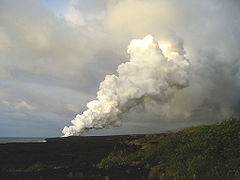
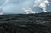 The current eruption has been going on now since 1983. Recent Kilauea Status Reports, Updates, and Information Releases are published daily by the Hawaii Volcano Observatory Historic photos and details of previous flows are also available on that website.
As of May 22nd 2011 the "Current Volcano Alert Level" was rated as being "WATCH".
Hawaii Volcanoes National Park, when constructed, had two entrances. The entrance via the lower Puna was cutoff in 1986 and several miles of the road along the ocean were paved by several flows that occurred over the course of the eruption. Tourists are particularly keen on observing the lava when it is flowing into the ocean and they can get a close look. To find out where the flow is currently going and best place to park consult links provided.
Lava flows have continued to add new land to the old shoreline in an intermittent fashion, with lava constantly changing directions and sometimes relocating into new areas. The lava itself, and the new land it creates can be hazardous and anyone visiting the area should consult publication Volcanic Hazards on the Island of Hawai`i
Additionally, the Volcano Observatory Website is the best place to check for any closures at the summit of Kīlauea. Occasionally, portions of Crater Rim Drive are closed owing to activity and venting of gas inside of Halemaumau Crater
. Trails may also be closed including several trails that lead inside and across the Kīlauea Caldera.
Affordable Land & Housing=
Between 2002 and 2006 the price of houses throughout the District of Puna often doubled and the price of vacant land in many areas of Puna increased anywhere from two to fivefold. Increasing numbers of people from outside the District of Puna, many from the mainland U.S., bought into the last affordable market in the state. However, despite this rise, overall, Puna continues to remain one of the least expensive areas of Hawaii
.
Two common misconceptions about Puna are frequently cited with no supporting evidence. One belief is that the area's rainfall helps depress land values and the other is that the risk of volcanic flow from Kilauea deters buyers. Both beliefs are false.
If rain was a valid factor, one would expect places in Hawaii that received more rain to be less desirable than Puna. However, Hawaii's rainiest spot is also one of the most expensive. Princeville, Hawaii
on Kauai's North Shore had estimated median house or condo value in 2009 of $865,280. Meanwhile drier and sunnier Puna had median or condo values in 2009 of only $230,612.
If volcanic risk was a valid factor, one would expect to find inexpensive homes in the riskiest areas. However, the reverse is true. Kapoho, Hawaii is right in the middle of the riskiest of all lava zones and the original town was inundated in 1960. Yet despite obvious and recent lava flow activity, Kapoho is the most expensive area of Puna with many homes going for over $1,000,000.
Leilani Estates, Hawaii is also in the riskiest zone, however, this neighborhood is considered to be one of the most desirable with a very active community association. Trees in Leilani Estates date back hundreds of years and only about 25% of the riskiest zone received a fresh surface in the last 200 years.
Insurance Issues=
To help guarantee the availability of homeowners insurance, the State of Hawaii formed the Hawaii Property Insurance Association (HPIA). Every provider of homeowners insurance in Hawaii is required to participate in this organization. All policies issued in Hawaii at a minimum most provide the same coverage outlined in the standard form fire insurance policy as authorized and in effect in the State of New York on December 31, 1943 and extended coverage
endorsement.
No one back in 1943 thought to write in an exclusion for volcanic activity in the State of New York, and as a consequence no insurance firms can use that as an excuse to deny a claim of fire caused by lava flow. All homeowners regardless of where they live in Hawaii have this protection despite what they may read in their policy fine print.
HPIA policies are sold via independent insurance representatives in Hawaii. HPIA caps insurance replacement coverage at $350,000. Homeowners also have the option of buying comprehensive policies with higher liability limits than HPIA through insurers like LLoyds of London.
Lava Zones in Hawaii=
The United States Geological Survey classified the Island of Hawaii into one of 9 different "Lava Zones". The map broadly outlines the probability of lava flow depending on the activity level of the 5 different volcanoes that form the Hawaii Island. Zone 1 represents the most likely to suffer damage and Zone 9 the least.
Areas where lava is likely to erupt directly from below are considered to be Zone 1. In Puna, Zone 1 is also known as the East-Rift Zone
and it extends from the top of Kilauea through Kapoho and down into the sea. Zone 2 is directly down-slope from this zone.
Most property damage owing to recent flow activity has occurred in Puna. Sections of [Kapoho]] were inundated in 1960, and an area known as Kalapana and Kaimū were effected by the current eruption that has been going on since 1983. Only approximately 10% or 50 square miles (129.5 km²) out of the 500 square miles (1,295 km²) of Puna have been covered by lava flows since 1790 when George Washington was still President of the US. Since 1983 the current flow has taken 190 structures.
by some lenders and insurance firms, the USGS 9 Zone system is being rethought and new Zones 11, 12, and 13 have been proposed to account for current lava flow activity.
Fresh Water in Puna=
Living in Puna has other unique considerations. For example, many homes in the District of Puna are located within private subdivisions which do not have any county or privately provided water services. Most homes within these subdivisions rely on rainwater catchment for their daily household water requirements. This proves feasible for many residents who live there because the amount of rainfall which occurs generally allows for an ample supply of water. However, this lack of residential water service and fire hydrants has been an ongoing issue with some homeowner insurance companies in regards to meeting the demands of firefighting, which could cause higher insurance premiums in some areas. During times of drought this can become problematic as the catchment tanks will run dry. Water then has to be delivered to homes by one of several privately owned water trucks. The water delivered by the truck is "free", however a delivery fee will be charged which runs anywhere from $100–$125 for around 3,500 gallons of water to be delivered to a home and placed in the tank.
Due to the lack of infrastructure requirements for most of the original landowners who created these "subdivisions", many large residential communities were created within the District of Puna which were completely off-grid and essentially severed from any county services. At the time these subdivisions were created during the late 1950s and throughout the 1960s, many people thought this wouldn't be a big issue. As time has moved forward these subdivisions have significantly increased in population.
US Postal Service post office boxes located within one of the local post offices are only available in a limited capacity from Keaau, Pāhoa, Kurtistown, Mountain View, and Volcano. The USPS has been inundated with requests for post office boxes, which they do not have available, prompting waiting lists for many people to get a private post office box. The USPS accommodates those residents who are unable to be provided with a private post office box an option to have their mail delivered to their local post office addressable to "General Delivery". The resident (or their designated representative) would then be required to come inside their local post office during business hours to collect any mail addressed as General Delivery.
Due to this increased availability of services throughout the area, combined with significantly lower prices of real estate and a boom in the housing market in the late 1990s
to early 2000s, home and land sales in Puna would skyrocket to levels never before seen from 2002-2006. This large volume of sales would significantly slow down after the real estate crisis hit the rest of the country in 2007.
Invasive Species=
There are many non-native plants which are thriving throughout the District of Puna. Another tree of notable mention is the invasive species Falcataria moluccana known locally in Puna as Albizia
, or the "Tree that Ate Puna".
Subcultures=
A major floral product seen in Puna is the cannabis
plant, as this has been a main underground staple of the Puna economy since the days of the sugar industry. Local law enforcement of "guerilla gardeners" of cannabis
(also known as marijuana or pakalolo in Hawaiian
) has been an ongoing battle in Puna. This continuous method of marijuana eradication from the air by helicopters has enraged many local residents throughout the years.
Pāhoa and many areas throughout Puna have been known to be populated by "hippies" or people who are into the "counter-culture". There is a significant cannabis movement in Puna. Certain locations in Puna have become notorious for their outright open consumption, and even in some places the distribution of cannabis, especially in areas around Pāhoa, Kapoho, Kalapana and Kehena. There are a few communities who practice communal lifestyle habits and there is a significantly large vegetarian or vegan community. Additionally, there are several yoga studios and health food stores located in an around Pāhoa.
Census-designated places and other areas within Puna=
Due to the land development from many years ago, Puna has the largest number of available building lots on the Island of Hawaii, numbering in over 50,000 buildable lots. Many of these subdivisions were created from the large tracts of private landowners who were able to arrange deals to create subdivisions without any major infrastructure requirements. Little thought was given at the time in the late 1950s of what would happen when people would actually move there to the slopes of Kīlauea.
Puna places of interest=
Besides visiting the active Kīlauea
volcano and the currently active lava flows in the area of Kalapana, another interesting site within the Puna district are the heated tide pools at Ahalanui Beach Park (aka Pualaa County Park), where spring water has been naturally heated through geothermal energy and this mixes with ocean water along the shoreline. Prior to the eruption in 1960 at Kapoho, the pools were not heated but were cold.
Notable people from Puna=
Hawaii County, Hawaii
Hawaii County is a county located in the U.S. state of Hawaii in the Hawaiian Islands. It is coterminous with the Island of Hawaii, often called the "Big Island" to distinguish it from the state as a whole. As of the 2010 Census the population was 185,079. The county seat is Hilo. There are no...
, Big Island
Hawaii (island)
The Island of Hawaii, also called the Big Island or Hawaii Island , is a volcanic island in the North Pacific Ocean...
, Hawaii
Hawaii
Hawaii is the newest of the 50 U.S. states , and is the only U.S. state made up entirely of islands. It is the northernmost island group in Polynesia, occupying most of an archipelago in the central Pacific Ocean, southwest of the continental United States, southeast of Japan, and northeast of...
. The District of Puna is located on the easternmost portion of the island and shares borders to the north with the District of South Hilo and a border to the west with the District of Kaū
Kau, Hawaii
thumb|right|300px|The districts of the [[Hawaii |Big Island]]. From Northernmost, clockwise; [[Kohala, Hawaii|Kohala]], [[Hamakua]], [[Hilo, Hawaii|Hilo]], [[Puna, Hawaii|Puna]], Kau , [[Kona District, Hawaii|Kona]]...
. With its size of just under 320000 acres (1,295 km²), Puna is slightly smaller than the island of Kauai
Kauai
Kauai or Kauai, known as Tauai in the ancient Kaua'i dialect, is geologically the oldest of the main Hawaiian Islands. With an area of , it is the fourth largest of the main islands in the Hawaiian archipelago, and the 21st largest island in the United States. Known also as the "Garden Isle",...
.
Summary=
In the Hawaiian language, puna can mean a spring (of water) and is also the name of the district. The shoreline of the Big Island is famous for its percolating spring water and along the coast in Puna there are several tide pools where one can experience the cold spring water bubbling up from the ground.
The eastern flank of Kīlauea
Kilauea
Kīlauea is a volcano in the Hawaiian Islands, and one of five shield volcanoes that together form the island of Hawaii. Kīlauea means "spewing" or "much spreading" in the Hawaiian language, referring to its frequent outpouring of lava. The Puu Ōō cone has been continuously erupting in the eastern...
lies completely within the District of Puna. Most terrain in Puna contains gradual slopes, (usually less than 15 degrees in angle/7.5% grade), which increase in elevation towards the summit of Kīlauea
Kilauea
Kīlauea is a volcano in the Hawaiian Islands, and one of five shield volcanoes that together form the island of Hawaii. Kīlauea means "spewing" or "much spreading" in the Hawaiian language, referring to its frequent outpouring of lava. The Puu Ōō cone has been continuously erupting in the eastern...
at the western point of the District.
Due to the porosity of the volcanic rock and the relative scarcity of any deep soil, there are no permanently running streams or waterways in the district of Puna. However, there are several intermittent streams which flow during periods of heavy rain. These streams usually disappear within several hours of the heavy precipitation. There is also an extensive network of subterranean lava tubes throughout much of the District of Puna which are sometimes accessible through collapsed openings.
Puna contains nearly 45% of Hawaii County's total subdivided lots, a low build-out percentage, and the highest growth rate, all on a landscape that is exposed to the highest risk of volcanic and seismic activity.
Agricultural tourism is emerging as part of a mix of attractions drawing more visitors to Puna. With the renewal of native Hawaiian culture and an appreciation for nature, Puna has established itself as a premier natural and cultural attraction, with Hawaii Volcanoes National Park
Hawaii Volcanoes National Park
Hawaii Volcanoes National Park, established in 1916, is a United States National Park located in the U.S. State of Hawaii on the island of Hawaii. It encompasses two active volcanoes: Kīlauea, one of the world's most active volcanoes, and Mauna Loa, the world's most massive volcano...
as a main draw.
Puna has a high percentage of lower-income residents, and the District of Puna is regarded as a place of opportunity for affordable housing. Many of the subdivision lots offer some of the lowest price home sites in Hawaii for owner-built housing. Approximately 85 percent of Hawaii Island's Section 8
Section 8 (housing)
Section 8 of the United States Housing Act of 1937 , as repeatedly amended, authorizes the payment of rental housing assistance to private landlords on behalf of approximately 3.1 million low-income households...
low-income rental housing certificate holders are Puna residents. Nevertheless, there are still many residents without adequate housing. Opportunities for retaining and expanding the stock of affordable housing are narrowing as land values rise in Puna and government housing subsidies shrink.
Introduction=
A distinguishing feature of Puna's native forest is its interaction with repeated, relatively recent lava flows, creating varied ages of forests underlain by different compositions of lava flows, ash and explosion deposits. This, in turn, enriches biodiversity, especially in older stands of forest, known as kīpuka
Kipuka
A kīpuka is an area of land completely surrounded by one or more younger lava flows. A kīpuka forms when lava flows on either side of a hill, ridge, or older lava dome as it moves downslope or spreads from its source. Older and more weathered than their surroundings, kīpukas often appear to be like...
, that have been isolated by younger lava flows.
Some of the native animal and plant species present in Puna are endemic to Hawaii, found nowhere else in the world. In addition, Puna harbors many other native species, such as
the Pueo
Pueo
The Pueo is a subspecies of Short-eared owl that is endemic to Hawaii. The pueo is one of the various nā aumākua in Hawaiian culture....
(Hawaiian Owl), the Amakihi, the Apapane, and various insects, some of which are rare.
Puna's unique lava tube caves are a notable geological feature and popular attraction. Kazumura Cave
Kazumura Cave
Kazumura Cave is a lava tube and has been surveyed at 40.7 miles long and 3,614 feet deep making it the longest and deepest lava tube in the world. The cave is located on the island of Hawaii on the eastern slope of Kilauea. Kilauea is the most recently active volcano on the Big Island...
is recognized as the world's longest lava cave at nearly 40 miles (64.4 km). The lava caves are also important as natural habitats for endemic cave-adapted species of insects and invertebrates. In addition, some of caves were used by ancient Hawaiians as burial sites for Alii
Ali'i
Alii is a word in the Polynesian language denoting chiefly status in ancient Hawaii and the Samoa Islands. A similar word with the same concept is found in other Polynesian societies. In the Cook Islands, an ariki is a high chief and the House of Ariki is a parliamentary house...
(royalty) and others.
Puna's geology and biological resources inspired reverence for the landscape by the original human inhabitants of Hawaii. By cultural tradition, Kīlauea is the home of the goddess Pele, giving the volcano and its surroundings a sacred status. Ancient Hawaiians recognized Puna as the land of Pele, with human habitation subject to Pele's will. Makaainana, or commoners, were free to relocate to other ahupuaa
Ahupua'a
In old Hawaii, ahupuaa was the common subdivision of the land. It is comparable to the tapere in the Southern Cook Islands. The traditional subdivision has four hierarchical levels:*mokupuni *moku...
(the lands of another chief) when Pele reasserted her dominion over the land. A map dated from 1826 indicates 24 ahupuaa located around the entire coast of Puna. While human settlement from ancient times was concentrated in a wide band of habitation within about 3 miles (5 km) of the shoreline, areas near the volcano and upper reaches of forest were visited for gathering as well as spiritual purposes.
Hilo and Kau are linked both geographically and historically through Puna. Prior to the arrival of western civilization there were routes which connected these two very different areas of the island through Puna. Many of the ancient trails, which are still protected as public land or with traditional access rights, connect areas of natural beauty that have cultural significance. Even though the 19th and 20th centuries brought rapid physical and cultural changes, some of the trails lead to remote spots that are important for traditional gathering and other cultural practices. The areas they traverse include some stands of fairly intact native vegetation with little modern development, offering a glimpse into the past.
Climate & Weather=
Climate in Puna varies with location (windward and leeward), and elevation (from sea level to over 4,000 feet). On the windward side, (the northern facing slopes of Kīlauea
Kilauea
Kīlauea is a volcano in the Hawaiian Islands, and one of five shield volcanoes that together form the island of Hawaii. Kīlauea means "spewing" or "much spreading" in the Hawaiian language, referring to its frequent outpouring of lava. The Puu Ōō cone has been continuously erupting in the eastern...
), rainfall is generally abundant (80 inches - 200 inches/year) with most of the rain falling around the 2,000 to 3000 ft (914.4 m) elevation (averaging above 140 inches/year in this elevation). On the leeward side, the southern facing slopes of the eastern rift of Kīlauea, there is significantly less rainfall (usually 40-80 inches). This reduced rainfall and cloud cover means there is a greater amount of direct sunlight received in the leeward areas than in the windward areas.
The climate along the coastal areas from sea level to about 500 feet (152.4 m) in elevation tends to be a mild tropical climate with fairly significant amounts of rain and milder temperatures. Rainfall amounts increase significantly on the windward facing slopes as one increases in elevation, with average rainfall amounts peaking at the 2800 feet (853.4 m) elevation, (near Glenwood). Noticeable cooling from sea level temperatures begins at around 1000 feet (304.8 m) with temperatures decreasing as one increases elevation, towards the summit of Kīlauea. The coolest temperatures in Puna tend to be near Volcano Village, which is around 4000 feet (1,219.2 m) in elevation.
Trade winds, which blow from the northeast to the southwest, are the common wind throughout most days on the windward side of Puna. In the evenings, cooler air from the slopes of Mauna Loa
Mauna Loa
Mauna Loa is one of five volcanoes that form the Island of Hawaii in the U.S. state of Hawaii in the Pacific Ocean, and the largest on Earth in terms of volume and area covered. It is an active shield volcano, with a volume estimated at approximately , although its peak is about lower than that...
sinks down toward Puna and this phenomenon causes air colder than normal to come down into Puna, dropping temperatures as much as 25°F overnight from the temperature at sunset.
Several locations flood during periods of heavy rainfall throughout Puna. Flooding in Puna is short lived, due to the high porosity of the volcanic rock and the lack of any significant soil to retain or hold the water. The lava flows on the slopes of Kīlauea are the newest on the island and therefore the amount of soil in this area is significantly reduced compared to other areas of the island which are much older. The slopes on Kīlauea have not had the time needed to erode yet and to form regularly running streams.
Historical background
Sandalwood
Sandalwood is the name of a class of fragrant woods from trees in the genus Santalum. The woods are heavy, yellow, and fine-grained, and unlike many other aromatic woods they retain their fragrance for decades. As well as using the harvested and cut wood in-situ, essential oils are also extracted...
export began in 1790, reaching its peak between 1810 and 1825. After Hawaii's first forestry law in 1839 restricted the removal of sandalwood trees, cattle ranching and coffee
Coffee
Coffee is a brewed beverage with a dark,init brooo acidic flavor prepared from the roasted seeds of the coffee plant, colloquially called coffee beans. The beans are found in coffee cherries, which grow on trees cultivated in over 70 countries, primarily in equatorial Latin America, Southeast Asia,...
cultivation became the leading commercial activities. By 1850, agriculture diversified with the cultivation of potatoes, onions, pumpkins, oranges
Orange (fruit)
An orange—specifically, the sweet orange—is the citrus Citrus × sinensis and its fruit. It is the most commonly grown tree fruit in the world....
, and molasses
Molasses
Molasses is a viscous by-product of the processing of sugar cane, grapes or sugar beets into sugar. The word molasses comes from the Portuguese word melaço, which ultimately comes from mel, the Latin word for "honey". The quality of molasses depends on the maturity of the sugar cane or sugar beet,...
.
Coffee & sugar days
Coffee
Coffee is a brewed beverage with a dark,init brooo acidic flavor prepared from the roasted seeds of the coffee plant, colloquially called coffee beans. The beans are found in coffee cherries, which grow on trees cultivated in over 70 countries, primarily in equatorial Latin America, Southeast Asia,...
was the chief agricultural crop in the area. Over 6000 acre of coffee trees were owned by approximately 200 independent coffee planters and 6 incorporated companies.
In 1899, the Olaa Sugar Company was founded. The coffee trees were uprooted to make way for sugarcane
Sugarcane
Sugarcane refers to any of six to 37 species of tall perennial grasses of the genus Saccharum . Native to the warm temperate to tropical regions of South Asia, they have stout, jointed, fibrous stalks that are rich in sugar, and measure two to six metres tall...
. Ōhia forests also had to be cleared, field rock piled, land plowed by mules or dug up by hand with a pick. Sugarcane was in large-scale production. In 1960, the company would be renamed the Puna Sugar Company due to a jinxed feeling of the name Olaa. The sugar mill operation ran for just over 80 years, until 1984. The plantation fields extended for 10 miles (16.1 km) along both sides of Highway 11 between Keaau and Mountain View (from sea level to 2,200 feet), as well as in the Pāhoa and Kapoho areas.
Within the last 15 years, some farmers began farming coffee again in the District of Puna, primarily in the Hawaiian Acres subdivision. Coffee has become an increasingly popular product to grow in Puna and some people seem to prefer Puna coffee over other Hawaiian coffee. Whether Puna coffee will return to the significant size of the 19th century has yet to be determined.
Macadamia & Papayas
Macadamia
Macadamia is a genus of nine species of flowering plants in the family Proteaceae, with a disjunct distribution native to eastern Australia , New Caledonia and Sulawesi in Indonesia ....
nuts and papaya
Papaya
The papaya , papaw, or pawpaw is the fruit of the plant Carica papaya, the sole species in the genus Carica of the plant family Caricaceae...
were introduced in 1881 and 1919 respectively. Since the closure of the Puna Sugar Company in 1991, papaya and macadamia nut production have become the leading cash crops of Puna, (along with cannabis
Cannabis
Cannabis is a genus of flowering plants that includes three putative species, Cannabis sativa, Cannabis indica, and Cannabis ruderalis. These three taxa are indigenous to Central Asia, and South Asia. Cannabis has long been used for fibre , for seed and seed oils, for medicinal purposes, and as a...
). About 97% of the state's papaya production occurs in Puna, primarily in the Kapoho area. The closure of sugar production in Puna potentially opened a large amount of agriculture land to a more diversified industry, although much of the former plantation land lies unused and covered predominantly by non-native trees, shrubs and grasses.
Mauna Loa Macadamia Nut Corporation
Mauna Loa Macadamia Nut Corporation
The Mauna Loa Macadamia Nut Corporation is the world's largest processor of macadamia nuts. The American company has been a subsidiary of The Hershey Company since 2004. The company takes its name from the volcano Mauna Loa...
has been running their macadamia growing operation out of Keaau continuously since 1948, with their first harvest in 1956. Their operation has grown to almost 10000 acres (40 km²) of orchards on the slopes of the Mauna Loa
Mauna Loa
Mauna Loa is one of five volcanoes that form the Island of Hawaii in the U.S. state of Hawaii in the Pacific Ocean, and the largest on Earth in terms of volume and area covered. It is an active shield volcano, with a volume estimated at approximately , although its peak is about lower than that...
volcano on the Big Island of Hawaii, on the Puna side of the border with the South Hilo district, just outside of Hilo town. This is also the location of the primary nut processing plant for the Mauna Loa Macadamia Nut Corporation
Mauna Loa Macadamia Nut Corporation
The Mauna Loa Macadamia Nut Corporation is the world's largest processor of macadamia nuts. The American company has been a subsidiary of The Hershey Company since 2004. The company takes its name from the volcano Mauna Loa...
which is now owned by The Hershey Company
The Hershey Company
The Hershey Company, known until April 2005 as the Hershey Foods Corporation and commonly called Hershey's, is the largest chocolate manufacturer in North America. Its headquarters are in Hershey, Pennsylvania, which is also home to Hershey's Chocolate World. It was founded by Milton S...
.
Diversified Agriculture
A variety of growing conditions supports diversified agriculture in Puna. Presently, Puna produces at least 40 different agricultural products including cut flowers, fruits, vegetables, and livestock. While the district is generally a wet, warm climate, drier conditions at lowland areas such as Kapoho are ideal for cultivating papaya, whereas wetter, cooler conditions in theVolcano area are suitable for growing crops that cannot thrive in many other areas of Hawaii. Even the wettest of areas have produced well under greenhouse cover. Also, due to volcanic activity, the age of the soils varies considerably throughout Puna, with corresponding variations in inherent natural fertility and tendency to resist weeds.
The cut flower industry
Floriculture
Floriculture, or flower farming, is a discipline of horticulture concerned with the cultivation of flowering and ornamental plants for gardens and for floristry, comprising the floral industry...
is a large part of the agricultural market in Puna. Orchids and anthuriums, some which are very rare, are the bulk of the cut flower market. Many types of agricultural products are sent out every day from Puna, via FedEx
FedEx
FedEx Corporation , originally known as FDX Corporation, is a logistics services company, based in the United States with headquarters in Memphis, Tennessee...
at Hilo International Airport
Hilo International Airport
Hilo International Airport , formerly General Lyman Field, is owned and operated by the Hawaii state Department of Transportation. Located in Hilo, Hawaii County, the airport encompasses and is one of two major airports on Hawaii Island and one of five major airports in the state...
, to customers all around the world.
Water Bottling=
Hawaiian Springs has their headquarters and main bottling plant located in Keaau. The water is artesian
Artesian aquifer
An artesian aquifer is a confined aquifer containing groundwater under positive pressure. This causes the water level in a well to rise to a point where hydrostatic equilibrium has been reached. This type of well is called an artesian well...
, bottled at the source; pumped directly from the aquifer to the bottling facility. It is 100% natural water bottled in Hawaii at the source, which distinguishes it from other "purified drinking water" or "filtered tap water" bottled in Hawaii and elsewhere around the world. Hawaiian Springs natural artesian water is distributed throughout Hawaii, and is now available in select US mainland and international markets.
Residential Living in Puna=
The recent pattern of residential development and population growth in Puna is the result of widespread land subdivision within the past half century. Between 1958 and 1973, more than 52,500 subdivision lots were created. Since that time, nearly 2,500 of these lots have been covered by lava flows or have been rendered unbuildable by shoreline subsidence, reflecting the risks of building on a landscape subject to volcanic and seismic hazards. Moreover, most subdivision lots are accessed by private, unpaved roads. The streets generally lack sidewalks and lighting, and do not meet current Hawaii County standards in terms of pavement width, vertical geometrics, drainage and other design parameters. None of the subdivisions have central sewer systems and only a couple have private water systems. Most lots rely on individual water catchment systems supplemented with private delivery trucks for potable water. Large sections of some subdivisions are off the power grid.
Despite the natural hazards and rudimentary infrastructure and services in these subdivisions, build-out of the lots has been occurring, especially within the northeast quadrant of Puna (from Keaau to Pāhoa) and in the vicinity of Volcano where the highest rates of population growth have been occurring. Puna is experiencing the fastest rate of growth of all the districts in the County of Hawaii. The U.S. Census population count in 2000 for Puna was 27,232. The 2010 U.S. Census results shows the population in Puna to now be 45,326, an increase of 66% in 10 years. By 2030, the population is projected to grow to approximately 75,000. Since only about one-quarter of the available lots have been developed at present, it is clear that these extensive subdivisions present formidable challenges to the natural environment and the rational management of development for future population growth.
The Planning Challenge
If Puna continues to develop at the present rate within the framework of the extensive subdivisions, there will be several types of significant, long-term consequences:- An increasing number of people and property improvements are being put at risk due to natural hazards. All of Puna lies within the three most hazardous geological risk zones: Lava Hazard Zones 1, 2 and 3 (LF1, LF2, and LF3). About 6,400 subdivision lots lie in the highest hazard zone, LF1, and over 500 of these are exposed to additional risks from subsidence, tsunami and earthquakes. The fact 2,038 lots in the lower hazard zone LF2 have been covered or cut off by lava flows in recent decades underscores the hazardous nature of much of the district.
- Because Puna's subdivisions are so large and have few arterial streets, evacuation of residents on short notice in the event a lava flow, earthquake, tsunami or hurricane is a significant problem with potentially serious consequences to public safety. The potential problem worsens as subdivision lots continue to develop and no infrastructure improvements are made.
- As more lots are developed, an increasing number of residents expect improved infrastructure. The cumulative impact of widespread use of cesspools on the quality of the aquifer and coastal waters is undetermined. Retrofitting infrastructure improvements is expensive, and not all residents are willing to either bear the cost or accept the transition from a “rural” setting to one that is more suburban.
- Because subdivision lots were sold in their undeveloped state rather than with dwellings, development has occurred in an uneven, “leap-frog” pattern, which makes it even more difficult to develop infrastructure and provide services to the population. Residents often must make long trips to employment, schools, shopping and other destinations to meet daily needs.
- While most of these subdivisions are on agricultural-zoned lands, the actual use of developed lots is predominantly residential. As residential development continues on these lots yet to be built on, it will be more difficult for existing small-lot agricultural uses to remain viable due to complaints from neighbors about nuisance effects of agricultural operations and potential increases in crop theft or vandalism.
Protected areas
Puna contains large areas of largely intact natural area that comes under the protection of Federal and State regulations; for example:- The western portion of Puna is dominated by Hawaii Volcanoes National ParkHawaii Volcanoes National ParkHawaii Volcanoes National Park, established in 1916, is a United States National Park located in the U.S. State of Hawaii on the island of Hawaii. It encompasses two active volcanoes: Kīlauea, one of the world's most active volcanoes, and Mauna Loa, the world's most massive volcano...
and the adjoining upper east Hawaii rainforest. The Park was designated by the United Nations Educational, Scientific, and Cultural Organization (UNESCO) as an International Biosphere Reserve in 1980, reflecting its value for research and protection of evolutionary resources, and as a World Heritage SiteWorld Heritage SiteA UNESCO World Heritage Site is a place that is listed by the UNESCO as of special cultural or physical significance...
in 1987, citing its geological resources. - The State of Hawaii designated two areas adjoining the Park as Natural Area Reserves—Kahaualea and Puu Makaala—meeting the same standards of resource quality and protective management as the Biosphere Reserve.
- The State of Hawaii also manages several other forest reserves in Puna comprising 131659 acres (533 km²): Upper Waiakea Forest Reserve, Waiakea Forest Reserve, Olaa Forest Reserve-Mountain View Section, Nanawale Forest Reserve, Mālama Kī Forest Reserve, Keauohana Forest Reserve, and the recently acquired Wao Kele O PunaWao Kele o PunaWao Kele O Puna is Hawaii's largest remaining lowland wet forest, about south of the city of Hilo, along the East Rift Zone of Kīlauea volcano on the Island of Hawaii. The name means the upland rainforest of Puna. Puna is one of 9 districts on the island...
Forest Reserve. - The State Conservation District, which encompasses almost all of the above areas as well as some additional lands, is organized as a regulatory hierarchy under the jurisdiction of the Hawaii Department of Land and Natural Resources (DLNR). There are five subzones of the Conservation District, each intended to provide a degree of regulatory protection that reflects the intactness or relative significance of the resources that are present in those subzones. About half of Puna's Conservation District is in the Protective Subzone, which is the most restrictive of the five subzones in terms of allowable uses. The remainder is in either the Limited Subzone, which is designated for areas with potential high risk of natural hazard, or the Resource Subzone, which is generally applied to less intact forest reserves.
- The Conservation District also includes the submerged lands beneath coastal waters. DLNR's Office of Conservation and Coastal Lands therefore addresses shoreline and near-shore issues and regulations. The Hawaii Department of Health (DOH) is responsible for monitoring and protecting the quality of the waters themselves under the authority of the Federal Clean Water ActClean Water ActThe Clean Water Act is the primary federal law in the United States governing water pollution. Commonly abbreviated as the CWA, the act established the goals of eliminating releases of high amounts of toxic substances into water, eliminating additional water pollution by 1985, and ensuring that...
.
Unprotected Areas
The remainder of Puna – about 56% of the entire land area of the district – lies predominately within the State Agricultural District and, to a lesser extent, in the State Urban and Rural Districts. The County has primary jurisdiction over land use and development in these Districts and can take proactive measures to protect resources in these areas, which encompass former agricultural fields and pastures, early towns and villages, extensive partially developed subdivisions, and large tracts of native forest.While much of the natural environment and some of the cultural heritage of these areas has been altered and compromised, effective and timely intervention can do much to prevent further degradation and possibly even restore some of what has been lost or undergoing change.
Historic, Cultural, and Scenic Resources
Only nine sites in Puna are listed on the Hawaii and/or National Register of Historic PlacesNational Register of Historic Places
The National Register of Historic Places is the United States government's official list of districts, sites, buildings, structures, and objects deemed worthy of preservation...
, but there are many other sites throughout the district that have been identified as having historic significance.
Puna's coastal areas have relatively dense concentrations of historical, cultural, and burial sites. Burial sites and cultural artifacts are not uncommon on subdivision lots, although many
are hidden in lava tubes, making them susceptible to destruction due to grading. While the State Historic Preservation Division (SHPD) plays a role in reviewing construction permits, Hawaii State law requires that construction activity be halted in the event of discovery of archaeological remains.
Puna's history is also evident in the architecture of its older towns and villages; namely, Keaau, the Kurtistown-Mountain View corridor, Pāhoa, and Volcano. Each of these places has a distinctive design character that reflects its history and location. Volcano presently has a small, legally recognized historic district, but otherwise there are no special design controls to preserve the design character of these towns.
Scenic natural settings are numerous in Puna, but they are, for the most part, protected by existing land use controls or public land agencies. Trails and scenic byways deserve special mention, since they are continuous visual experiences along a designated corridor and are particularly vulnerable to loss.
Puna Healthcare=
There are no hospital facilities in the District of Puna. With a growing population, Puna needs more social and health care services within the District of Puna boundaries. Yet, there are two major challenges to making them accessible to residents:
- As a rural area with a rudimentary transportation system and dispersed population, it is difficult for residents in need to reach the services; and
- Puna's high percentage of low-income residents tends to increase the need for social services, yet discourages private health care providers from locating in Puna due to insurance issues.
Public Safety & Sanitation Services in Puna=
Public safety and sanitation services in Puna have needed to adapt to the widely dispersed settlement pattern in the District of Puna and the poor road conditions throughout most of the subdivisions. It is neither cost-efficient nor practical for the County of Hawaii to provide a sufficient number of police, fire and paramedical facilities with associated staffing and equipment to provide coverage to all populated areas with the response times that are typical of urban or most suburban areas. Therefore, County services are supplemented with community policing programs and volunteer fire stations, usually with at least some degree of County assistance in the form of training, equipment and/or personnel.
There are no public wastewater treatment systems in Puna. Similarly, there is no municipal house-to-house solid waste collection service. Most homes have a cesspool for wastewater which goes directly into the ground. The County provides solid waste transfer stations located in Pāhoa, Glenwood, Volcano, Kalapana, and Keaau. Until recently, all solid waste was disposed in landfills. Following previous upgrades to the Keaau solid waste transfer station the County upgraded the Pāhoa, Glenwood, and Volcano facilities in late 2007 to support recycling, including an improved redemption center for bottles and cans, collection bins for scrap metal, mixed recyclables, and green waste.
A new fire station was recently opened in 2010 just outside of Pāhoa on Highway 130. A new police station is currently under construction directly adjacent to the fire station and should be completed some time in 2011.
Parks & recreation in Puna=
Puna contains most of Hawaii Volcanoes National Park
Hawaii Volcanoes National Park
Hawaii Volcanoes National Park, established in 1916, is a United States National Park located in the U.S. State of Hawaii on the island of Hawaii. It encompasses two active volcanoes: Kīlauea, one of the world's most active volcanoes, and Mauna Loa, the world's most massive volcano...
, which is the premier nature park in the Hawaiian Islands
Hawaiian Islands
The Hawaiian Islands are an archipelago of eight major islands, several atolls, numerous smaller islets, and undersea seamounts in the North Pacific Ocean, extending some 1,500 miles from the island of Hawaii in the south to northernmost Kure Atoll...
, (although the actual entrance to the park is located in the District of Kau). Added to the inventory of nature parks are the State-owned: MacKenzie State Recreation Area (13.1 acres (53,013.9 m²)), located between Pohoiki and Opihikao at the edge of the Mālama-Kī Forest Reserve; and Lava Tree State Monument
Lava Tree State Monument
Lava Tree State Monument is a public park located southeast of Pāhoa in the Puna District on the island of Hawaii.It preserves lava molds of the tree trunks that were formed when a lava flow swept through a forested area in 1790.-Features:...
(17.1 acres (69,201.3 m²)), located near the junction of Kapoho-Pahoa Road and Pohoiki Road. There is also an undeveloped State parcel of 78.3 acres (316,869.1 m²) located adjacent to Honolulu Landing along the Puna Coast Road between Kapoho and the Hawaiian Shores subdivision that at one time had been provided to the County of Hawaii by the State through Executive Order for development as a park.
The County owns smaller shoreline parks: two undeveloped sites within Hawaiian Paradise Park; Isaac Hale Beach Park
Isaac Hale Beach Park
thumb|280px|Isaac Hale Beach Park from pierIsaac Hale Beach Park, also known as Pohoiki is an oceanfront park, boat launch and surf location along Pohoiki Bay in the Puna district of the Big Island of Hawaii. It is only one of a few places in the Southeast shore of Hawaii that allows for such...
, located adjacent to Pohoiki Bay; and the nearby Ahalanui
Park site, which was purchased in 1993 to replace the two former parks (Kaimū Beach Park and Harry K. Brown Park) that were destroyed by lava flows.
There are few community parks in the District of Puna for active recreation. The largest public facilities are the County's W. H. Shipman
William Herbert Shipman
William Herbert Shipman was a wealthy businessman on the island of Hawaii. One estate of his family was used to preserve an endangered species of Hawaiian Goose. A historic house associated with his family for over a hundred years is called the W. H. Shipman House in Hilo, Hawaii...
Park in Keaau and Pāhoa Park, which includes a pool and a neighborhood center for meetings, programs and indoor recreational activities. The County of Hawaii maintains a gymnasium at Mountain View, outdoor basketball courts at Kurtistown and Hawaiian Beaches, and tennis courts at Kurtistown and Keaau.
The Department of Education maintains recreational facilities at their schools in Keaau, Pāhoa and Mountain View, but these are primarily for use by students and not always available for general community use. There are also some recreational facilities that are owned and maintained by community associations. Some of the subdivisions contain undeveloped parcels that have been set aside for future community use, including parks. However, funds have not been available to develop significant facilities on them, either from private or public sources.
Energy Demands in Puna=
Puna's energy demand continues to rise because of rapidly increasing residential development. The cost of installing and maintaining the electrical grid is very high because of weather, vegetation, and the relatively great distances from house-to-house. Many people live "off-the-grid"; that is where dwellings are not connected to the electrical power service provided by the local utility company Hawaiian Electric Light Company (HELCO), particularly in more remote locations. While many residences remain unconnected to the power grid, some choose to connect to the grid to supply at least a portion of their power needs or to provide back-up power.
There are two power generation facilities in Puna. HELCO's Puna Steam Plant and the geothermal power generation source at Kapoho operated by Puna Geothermal Venture (PGV).
The first geothermal well in Hawaii tapping volcanic steam for energy was drilled in 1976, in the District of Puna. Today there are now six wells which provide over 25% of Hawaii County's power.
Transportation in Puna=
Sprawl development is increasingly evident in the travel patterns of Puna residents. At present, most of Puna's workforce commutes by personal vehicle to employment locations outside of the District, primarily to Hilo. Residents also make frequent trips to Hilo for shopping and services. About a quarter of the workforce carpools, but congestion is growing along Puna's principal corridors during peak commute periods.
State highways are the primary transportation routes. Highway 11 between Kurtistown and Hilo and Highway 130 between Pāhoa and Keaau carry the greatest amount of traffic during peak commuting periods. Most roads in Puna's nonconforming subdivisions are privately owned, often in poor physical condition and not designed for through traffic. There are many missing connections between the road networks of adjacent subdivisions. The present circulation network, combined with the district’s sprawl development pattern, results in a number of problems:
- There is a lack of alternative routes for emergency access, especially when highways are blocked by a traffic crash or downed utility pole, or when there is a natural disaster such as a hurricane, tsunami, lava flow or earthquake that requires evacuation;
- Highways become more congested during peak periods due to the lack of alternative roadways;
- Highway intersections with substandard private streets are dangerous due to inadequate lighting or intersection controls, combined with high traffic speed along the highway;
- It is difficult for the County’s Mass Transit Agency (MTA) to operate an efficient Hele-On Bus service that offers a viable travel option for a large number of Puna residents, especially those in more remote areas;
- There are few facilities for walking or bicycling, even in more built-up areas; and
- It can be life-threatening to cross Highways 130 and 11 on foot. This is particularly true for youth, the elderly and the disabled.
Mass transit
Poor road conditions, combined with incomplete connectivity in the street system and a dispersed pattern of development, make it challenging to devise and sustain a viable mass transit system for Puna. The County’s Hele-On bus operates a Hilo-Pāhoa route along Highway 130 five times a day, and a Hilo-Kau route along Highway 11 once a day. These are long, circuitous routes that, while providing reasonably good coverage to more remote areas, also results in high operating costs and lengthy trip time that discourages ridership. While the 2000 United States Census indicated that less than 1% of Puna's workforce commuted by bus, ridership more than doubled after the County initiated a free fare service between Pāhoa and Hilo in 2005.The County Mass Transit Agency (MTA) is currently planning significant system improvements by converting to a “hub-and-spoke” system, consisting of the following elements:
- Large Hele-On coaches operating frequent runs on a shorter route between Hilo and a primary Puna "hub" at Keaau and secondary hubs at Pāhoa and other village centers near highways.
- Paratransit vans to pick-up passengers who have called in from outlying areas to be brought to one of the transit hubs.
- Central coordination by MTA of all paratransit services, including those operated by social service agencies for designated residents with special needs.
- Park-and-ride lots at transit hubs and possibly other locations.
Road networks
Presently, the County maintains nearly 188 miles (302.6 km) of roads in Puna, including some that serve as collector roads and emergency access routes, as well as some local paved streets in a limited number of subdivisions. Roads within most subdivisions are privately-owned and maintained by community road maintenance associations. Most of the roads are narrow and lack paving, lighting, traffic control signs and drainage systems. In many sections, there is inadequate sight distance due to sharp curves or irregular road gradients. There is also poor roadway connectivity between most subdivisions, which means that one must take a circuitous route to travel from one subdivision to another. This, in turn, puts an additional strain on the highways and the few collector streets in the network. Of greater concern to public safety in an area prone to natural hazards, there are few alternative routes for emergency access and evacuation. The rapidly developing subdivisions whose principal access is Highway 130 are of particular concern.Highways
There are four highways within the district of Puna:- Volcano Highway (Highway 11), which provides access to and from Hilo, serves the upper Puna region, and connects Puna to Ka‘u;
- Puna Road (Highway 130), which runs from Kea‘au to Kalapana-Kaimu, providing access from upper to lower Puna;
- Kapoho Road (Highway 132), which spans between Pāhoa and Kapoho; and
- Puna Coast Road (Highway 137), which links Kapoho to Kalapana-Kaimu.
Highways 11 and 130 are under the jurisdiction of the State of Hawaii Department of Transportation (DOT).
Non-motorized travel & scenic byways
Within Puna, bicycle and pedestrian facilities are very limited. Two multi-use trails of significant length are planned. One is the restoration and improvement of Old Volcano Trail, which roughly parallels Highway 11 for a length of about 14 miles (23 km) between Keaau and Volcano. The other is Puna Railroad Bikeway, which, as the name implies, follows the alignment of the former railroad and a portion of Railroad Avenue, and would extend between Kapoho and Hilo, traversing Hawaiian Paradise Park (HPP). The first project is now underway, but the second project requires acquisition of a substantial amount of right-of-way from private owners before it can proceed.Recent Lava Activity=
As of May 22nd 2011 the "Current Volcano Alert Level" was rated as being "WATCH".
Hawaii Volcanoes National Park, when constructed, had two entrances. The entrance via the lower Puna was cutoff in 1986 and several miles of the road along the ocean were paved by several flows that occurred over the course of the eruption. Tourists are particularly keen on observing the lava when it is flowing into the ocean and they can get a close look. To find out where the flow is currently going and best place to park consult links provided.
Lava flows have continued to add new land to the old shoreline in an intermittent fashion, with lava constantly changing directions and sometimes relocating into new areas. The lava itself, and the new land it creates can be hazardous and anyone visiting the area should consult publication Volcanic Hazards on the Island of Hawai`i
Additionally, the Volcano Observatory Website is the best place to check for any closures at the summit of Kīlauea. Occasionally, portions of Crater Rim Drive are closed owing to activity and venting of gas inside of Halemaumau Crater
Halemaumau Crater
Halemaumau crater is a pit crater located within the much larger summit caldera of Kīlauea in Hawaii Volcanoes National Park. The roughly circular crater floor is x and is below the floor of Kīlauea caldera, located at coordinates . Halemaumau is home to Pele, Goddess of Hawaiian Volcanoes,...
. Trails may also be closed including several trails that lead inside and across the Kīlauea Caldera.
Affordable Land & Housing=
Between 2002 and 2006 the price of houses throughout the District of Puna often doubled and the price of vacant land in many areas of Puna increased anywhere from two to fivefold. Increasing numbers of people from outside the District of Puna, many from the mainland U.S., bought into the last affordable market in the state. However, despite this rise, overall, Puna continues to remain one of the least expensive areas of Hawaii
Hawaii
Hawaii is the newest of the 50 U.S. states , and is the only U.S. state made up entirely of islands. It is the northernmost island group in Polynesia, occupying most of an archipelago in the central Pacific Ocean, southwest of the continental United States, southeast of Japan, and northeast of...
.
Two common misconceptions about Puna are frequently cited with no supporting evidence. One belief is that the area's rainfall helps depress land values and the other is that the risk of volcanic flow from Kilauea deters buyers. Both beliefs are false.
If rain was a valid factor, one would expect places in Hawaii that received more rain to be less desirable than Puna. However, Hawaii's rainiest spot is also one of the most expensive. Princeville, Hawaii
Princeville, Hawaii
Princeville is a census-designated place on the north shore of the island of Kauai in Kauai County, Hawaii, United States. The population was 1,698 at the 2000 census.-Geography:Princeville is located at ....
on Kauai's North Shore had estimated median house or condo value in 2009 of $865,280. Meanwhile drier and sunnier Puna had median or condo values in 2009 of only $230,612.
If volcanic risk was a valid factor, one would expect to find inexpensive homes in the riskiest areas. However, the reverse is true. Kapoho, Hawaii is right in the middle of the riskiest of all lava zones and the original town was inundated in 1960. Yet despite obvious and recent lava flow activity, Kapoho is the most expensive area of Puna with many homes going for over $1,000,000.
Leilani Estates, Hawaii is also in the riskiest zone, however, this neighborhood is considered to be one of the most desirable with a very active community association. Trees in Leilani Estates date back hundreds of years and only about 25% of the riskiest zone received a fresh surface in the last 200 years.
Insurance Issues=
To help guarantee the availability of homeowners insurance, the State of Hawaii formed the Hawaii Property Insurance Association (HPIA). Every provider of homeowners insurance in Hawaii is required to participate in this organization. All policies issued in Hawaii at a minimum most provide the same coverage outlined in the standard form fire insurance policy as authorized and in effect in the State of New York on December 31, 1943 and extended coverage
Extended coverage
Extended coverage is a term used in the property insurance business. All insurance policies have exclusions - specific causes of loss that are not covered by the insurance company. An Extended coverage endorsement was a common extension of property insurance beyond coverage for fire and lightning...
endorsement.
No one back in 1943 thought to write in an exclusion for volcanic activity in the State of New York, and as a consequence no insurance firms can use that as an excuse to deny a claim of fire caused by lava flow. All homeowners regardless of where they live in Hawaii have this protection despite what they may read in their policy fine print.
HPIA policies are sold via independent insurance representatives in Hawaii. HPIA caps insurance replacement coverage at $350,000. Homeowners also have the option of buying comprehensive policies with higher liability limits than HPIA through insurers like LLoyds of London.
Lava Zones in Hawaii=
The United States Geological Survey classified the Island of Hawaii into one of 9 different "Lava Zones". The map broadly outlines the probability of lava flow depending on the activity level of the 5 different volcanoes that form the Hawaii Island. Zone 1 represents the most likely to suffer damage and Zone 9 the least.
Areas where lava is likely to erupt directly from below are considered to be Zone 1. In Puna, Zone 1 is also known as the East-Rift Zone
Rift zone
A rift zone is a feature of some volcanoes, especially the shield volcanoes of Hawaii, in which a linear series of fissures in the volcanic edifice allows lava to be erupted from the volcano's flank instead of from its summit...
and it extends from the top of Kilauea through Kapoho and down into the sea. Zone 2 is directly down-slope from this zone.
Most property damage owing to recent flow activity has occurred in Puna. Sections of [Kapoho]] were inundated in 1960, and an area known as Kalapana and Kaimū were effected by the current eruption that has been going on since 1983. Only approximately 10% or 50 square miles (129.5 km²) out of the 500 square miles (1,295 km²) of Puna have been covered by lava flows since 1790 when George Washington was still President of the US. Since 1983 the current flow has taken 190 structures.
Lender and Insurance Redlining Of Lava Zone 1 and 2
In response to the redliningRedlining
Redlining is the practice of denying, or increasing the cost of services such as banking, insurance, access to jobs, access to health care, or even supermarkets to residents in certain, often racially determined, areas. The term "redlining" was coined in the late 1960s by John McKnight, a...
by some lenders and insurance firms, the USGS 9 Zone system is being rethought and new Zones 11, 12, and 13 have been proposed to account for current lava flow activity.
Fresh Water in Puna=
Living in Puna has other unique considerations. For example, many homes in the District of Puna are located within private subdivisions which do not have any county or privately provided water services. Most homes within these subdivisions rely on rainwater catchment for their daily household water requirements. This proves feasible for many residents who live there because the amount of rainfall which occurs generally allows for an ample supply of water. However, this lack of residential water service and fire hydrants has been an ongoing issue with some homeowner insurance companies in regards to meeting the demands of firefighting, which could cause higher insurance premiums in some areas. During times of drought this can become problematic as the catchment tanks will run dry. Water then has to be delivered to homes by one of several privately owned water trucks. The water delivered by the truck is "free", however a delivery fee will be charged which runs anywhere from $100–$125 for around 3,500 gallons of water to be delivered to a home and placed in the tank.
Due to the lack of infrastructure requirements for most of the original landowners who created these "subdivisions", many large residential communities were created within the District of Puna which were completely off-grid and essentially severed from any county services. At the time these subdivisions were created during the late 1950s and throughout the 1960s, many people thought this wouldn't be a big issue. As time has moved forward these subdivisions have significantly increased in population.
US Mail in Puna
US Mail service for many Puna residents (especially within the numerous private subdivisions) is usually to a clustered central mailbox at various points within the subdivisions, addressed as a HC or (Highway Contract) delivery address, rather than mail delivery to an actual residence. While these private cluster boxes are controlled by the USPS, mail to these locations is delivered via a private contractor and not the USPS directly, (hence the HC).US Postal Service post office boxes located within one of the local post offices are only available in a limited capacity from Keaau, Pāhoa, Kurtistown, Mountain View, and Volcano. The USPS has been inundated with requests for post office boxes, which they do not have available, prompting waiting lists for many people to get a private post office box. The USPS accommodates those residents who are unable to be provided with a private post office box an option to have their mail delivered to their local post office addressable to "General Delivery". The resident (or their designated representative) would then be required to come inside their local post office during business hours to collect any mail addressed as General Delivery.
Increasing Utilities in Puna
With a steadily increasing population over the last 20 years throughout Puna, a demand for more readily available electric and telephone services became apparent. Utility companies continued to bring in more services as the population in the area grew. Services such as high-speed cable and DSL internet access, which were practically unavailable in Puna only 10 years ago, have become a more common feature throughout the District of Puna. Areas which used to have party-line telephone service as recent as 10 years ago, have now advanced forward into the digital age. However, there are still several areas throughout Puna which are completely off-grid, (without utility company services of any type). Many people in these areas seem to prefer the disconnected lifestyle and say it reminds them of a Hawaii from long ago.Due to this increased availability of services throughout the area, combined with significantly lower prices of real estate and a boom in the housing market in the late 1990s
1990s
File:1990s decade montage.png|From left, clockwise: The Hubble Space Telescope floats in space after it was taken up in 1990; American F-16s and F-15s fly over burning oil fields and the USA Lexie in Operation Desert Storm, also known as the 1991 Gulf War; The signing of the Oslo Accords on...
to early 2000s, home and land sales in Puna would skyrocket to levels never before seen from 2002-2006. This large volume of sales would significantly slow down after the real estate crisis hit the rest of the country in 2007.
Invasive Species=
There are many non-native plants which are thriving throughout the District of Puna. Another tree of notable mention is the invasive species Falcataria moluccana known locally in Puna as Albizia
Falcataria
Falcataria is a genus of flowering plants in the legume family, Fabaceae. It belongs to the subfamily Mimosoideae....
, or the "Tree that Ate Puna".
Subcultures=
A major floral product seen in Puna is the cannabis
Cannabis
Cannabis is a genus of flowering plants that includes three putative species, Cannabis sativa, Cannabis indica, and Cannabis ruderalis. These three taxa are indigenous to Central Asia, and South Asia. Cannabis has long been used for fibre , for seed and seed oils, for medicinal purposes, and as a...
plant, as this has been a main underground staple of the Puna economy since the days of the sugar industry. Local law enforcement of "guerilla gardeners" of cannabis
Cannabis
Cannabis is a genus of flowering plants that includes three putative species, Cannabis sativa, Cannabis indica, and Cannabis ruderalis. These three taxa are indigenous to Central Asia, and South Asia. Cannabis has long been used for fibre , for seed and seed oils, for medicinal purposes, and as a...
(also known as marijuana or pakalolo in Hawaiian
Hawaiian language
The Hawaiian language is a Polynesian language that takes its name from Hawaii, the largest island in the tropical North Pacific archipelago where it developed. Hawaiian, along with English, is an official language of the state of Hawaii...
) has been an ongoing battle in Puna. This continuous method of marijuana eradication from the air by helicopters has enraged many local residents throughout the years.
Pāhoa and many areas throughout Puna have been known to be populated by "hippies" or people who are into the "counter-culture". There is a significant cannabis movement in Puna. Certain locations in Puna have become notorious for their outright open consumption, and even in some places the distribution of cannabis, especially in areas around Pāhoa, Kapoho, Kalapana and Kehena. There are a few communities who practice communal lifestyle habits and there is a significantly large vegetarian or vegan community. Additionally, there are several yoga studios and health food stores located in an around Pāhoa.
Census-designated places and other areas within Puna=
Due to the land development from many years ago, Puna has the largest number of available building lots on the Island of Hawaii, numbering in over 50,000 buildable lots. Many of these subdivisions were created from the large tracts of private landowners who were able to arrange deals to create subdivisions without any major infrastructure requirements. Little thought was given at the time in the late 1950s of what would happen when people would actually move there to the slopes of Kīlauea.
- Āinaloa
- Fern Acres
- Fern Forest
- Glenwood
- Hawaiian Acres
- Hawaiian Beaches
- Hawaiian Paradise Park
- Kalapana
- Kapoho
- Keaau
- Kehena
- Kurtistown
- Mountain View
- Nānāwale Estates
- Orchidland
- Pāhoa
- Volcano Village
Puna places of interest=
Besides visiting the active Kīlauea
Kilauea
Kīlauea is a volcano in the Hawaiian Islands, and one of five shield volcanoes that together form the island of Hawaii. Kīlauea means "spewing" or "much spreading" in the Hawaiian language, referring to its frequent outpouring of lava. The Puu Ōō cone has been continuously erupting in the eastern...
volcano and the currently active lava flows in the area of Kalapana, another interesting site within the Puna district are the heated tide pools at Ahalanui Beach Park (aka Pualaa County Park), where spring water has been naturally heated through geothermal energy and this mixes with ocean water along the shoreline. Prior to the eruption in 1960 at Kapoho, the pools were not heated but were cold.
- Ahalanui Beach Park
- Akatsuka Orchid Gardens
- Hawaii Volcanoes National ParkHawaii Volcanoes National ParkHawaii Volcanoes National Park, established in 1916, is a United States National Park located in the U.S. State of Hawaii on the island of Hawaii. It encompasses two active volcanoes: Kīlauea, one of the world's most active volcanoes, and Mauna Loa, the world's most massive volcano...
, (the entrance is actually inside the district of KaūKau, Hawaiithumb|right|300px|The districts of the [[Hawaii |Big Island]]. From Northernmost, clockwise; [[Kohala, Hawaii|Kohala]], [[Hamakua]], [[Hilo, Hawaii|Hilo]], [[Puna, Hawaii|Puna]], Kau , [[Kona District, Hawaii|Kona]]...
) - Hilo Coffee Mill, Mountain View
- Issac Hale Beach Park (Pohoiki)Isaac Hale Beach Parkthumb|280px|Isaac Hale Beach Park from pierIsaac Hale Beach Park, also known as Pohoiki is an oceanfront park, boat launch and surf location along Pohoiki Bay in the Puna district of the Big Island of Hawaii. It is only one of a few places in the Southeast shore of Hawaii that allows for such...
- J. Hara Store, Kurtistown
- Kalani Honua Retreat Center
- Keaau Shopping Center
- MacKenzie State Recreation Area
- Makuu Farmer's Market
- Mauna Loa Macadamia Nut CorporationMauna Loa Macadamia Nut CorporationThe Mauna Loa Macadamia Nut Corporation is the world's largest processor of macadamia nuts. The American company has been a subsidiary of The Hershey Company since 2004. The company takes its name from the volcano Mauna Loa...
- Lava Tree State Monument
- Pāhoa Park
- Puna Hongwanji Mission
- Star of the Sea Painted Church
- Ulua Theatre, Volcano Village
- Volcano Skate Park
- W. H. Shipman Park
Notable people from Puna=
- Jason Scott Lee, Actor, owner and creator of Ulua Theatre, Volcano Village resident
- William "Billy" Kenoi, Mayor of Hawaii County (2008–present)
- Harry KimHarry Kim (politician)Harry Kim is a former mayor of Hawaii County, Hawaii. Hawaii County is the government of Hawaii island, known as the Big Island. He was elected in 2000, and served until 2008.- Life :...
, Mayor of Hawaii County (2000–2008) - Joseph NāwahīJoseph NawahiJoseph Nāwahī also known as Joseph Kahooluhi Nāwahī and as Joseph Kahooluhi Nāwahīokalaniōpuu was a native Hawaiian legislator, lawyer, newspaper publisher, and painter.-Life:...
, Native Hawaiian legislator, newspaper publisher, and painter - Emily Naeole, Hawaii County Councilwoman
- Abra MooreAbra MooreAbra Moore is a folk-styled rock singer-songwriter. Her 1997 album Strangest Places included the hit "Four Leaf Clover", which received airplay in Midwest U.S. radio markets and VH1 and MTV2 rotation, and charted on the Billboard Hot 100.-Biography:Moore's parents named Abra after the heroine of...
, Folk-styled rock singer-songwriter - William H. ShipmanWilliam Herbert ShipmanWilliam Herbert Shipman was a wealthy businessman on the island of Hawaii. One estate of his family was used to preserve an endangered species of Hawaiian Goose. A historic house associated with his family for over a hundred years is called the W. H. Shipman House in Hilo, Hawaii...
, Founder of W. H. Shipman Ltd., agricultural entrepreneur, and major private land owner in Puna - Herbert C. Shipman, Son of W. H. Shipman, known for saving nēnēHawaiian GooseThe Nene, also known as Nēnē and Hawaiian Goose, is a species of goose endemic to the Hawaiian Islands. The official bird of the state of Hawaii, the Nene is exclusively found in the wild on the islands of Maui, Kauai and Hawaii...
through breeding at the Shipman Estate