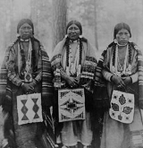
Warm Springs Indian Reservation
Overview
Oregon
Oregon is a state in the Pacific Northwest region of the United States. It is located on the Pacific coast, with Washington to the north, California to the south, Nevada on the southeast and Idaho to the east. The Columbia and Snake rivers delineate much of Oregon's northern and eastern...
, in the United States
United States
The United States of America is a federal constitutional republic comprising fifty states and a federal district...
, and is occupied and governed by the Confederated Tribes of Warm Springs
Confederated Tribes of Warm Springs
The Confederated Tribes of Warm Springs is a federally recognized confederation of Native American Tribes who currently live on and govern the Warm Springs Indian Reservation in the U.S...
.
Three tribes form the confederation: the Wasco, Warm Springs and Paiute
Paiute
Paiute refers to three closely related groups of Native Americans — the Northern Paiute of California, Idaho, Nevada and Oregon; the Owens Valley Paiute of California and Nevada; and the Southern Paiute of Arizona, southeastern California and Nevada, and Utah.-Origin of name:The origin of...
. Since 1938 they have been unified as the Confederated Tribes of Warm Springs.
The reservation was created by treaty
Treaty
A treaty is an express agreement under international law entered into by actors in international law, namely sovereign states and international organizations. A treaty may also be known as an agreement, protocol, covenant, convention or exchange of letters, among other terms...
in 1855, which defined its boundaries as follows:
Commencing in the middle of the channel of the Deschutes River opposite the eastern termination of a range of high lands usually known as the Mutton Mountains; thence westerly to the summit of said range, along the divide to its connection with the Cascade MountainsCascade RangeThe Cascade Range is a major mountain range of western North America, extending from southern British Columbia through Washington and Oregon to Northern California. It includes both non-volcanic mountains, such as the North Cascades, and the notable volcanoes known as the High Cascades...
; thence to the summit of said mountains; thence southerly to Mount JeffersonMount Jefferson (Oregon)Mount Jefferson is a stratovolcano in the Cascade Volcanic Arc, part of the Cascade Range, and is the second highest mountain in Oregon. Situated in the far northeastern corner of Linn County on the Jefferson County line, about east of Corvallis, Mount Jefferson is in a rugged wilderness and is...
; thence down the main branch of Deschutes River; heading in this peak, to its junction with Deschutes River; and thence down the middle of the channel of said river to the place of beginning.
The Warm Springs and Wasco bands gave up ownership rights to 10000000 acres (40,468.6 km²) area, which they had inhabited for over 10,000 years, in exchange for basic health care, education, and other forms of assistance as outlined by the Treaty with the Tribes of Middle Oregon (June 25, 1855).
Unanswered Questions

