

Puunene
Encyclopedia
Unincorporated area
In law, an unincorporated area is a region of land that is not a part of any municipality.To "incorporate" in this context means to form a municipal corporation, a city, town, or village with its own government. An unincorporated community is usually not subject to or taxed by a municipal government...
in the central part of Maui
Maui
The island of Maui is the second-largest of the Hawaiian Islands at and is the 17th largest island in the United States. Maui is part of the state of Hawaii and is the largest of Maui County's four islands, bigger than Lānai, Kahoolawe, and Molokai. In 2010, Maui had a population of 144,444,...
, Hawaii
Hawaii
Hawaii is the newest of the 50 U.S. states , and is the only U.S. state made up entirely of islands. It is the northernmost island group in Polynesia, occupying most of an archipelago in the central Pacific Ocean, southwest of the continental United States, southeast of Japan, and northeast of...
, near Kahului. Although the land in that area is fairly level, the words Puu nēnē mean "nene
Hawaiian Goose
The Nene, also known as Nēnē and Hawaiian Goose, is a species of goose endemic to the Hawaiian Islands. The official bird of the state of Hawaii, the Nene is exclusively found in the wild on the islands of Maui, Kauai and Hawaii...
goose hill" in Hawaiian
Hawaiian language
The Hawaiian language is a Polynesian language that takes its name from Hawaii, the largest island in the tropical North Pacific archipelago where it developed. Hawaiian, along with English, is an official language of the state of Hawaii...
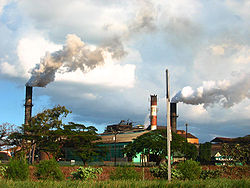
. With a population of around 50, Puunēnē's primary industry is growing, harvesting and processing sugar cane.
The nonprofit Alexander & Baldwin Sugar Museum is housed in the former residence of the superintendent of Puunēnē Sugar Mill, which the Hawaiian Commercial & Sugar Company (a division of Alexander & Baldwin
Alexander & Baldwin
Following World War II, the company entered a new business: land development and real estate. The company formed a new subsidiary, the Kahului Development Co., to develop housing in the Kahului area. In the following years, the company became more involved in the development of its land and the...
) has operated across the street since 1901. Its mission is "to preserve and present the history and heritage of Hawaii's sugar industry, and the multi-ethnic
Multiculturalism
Multiculturalism is the appreciation, acceptance or promotion of multiple cultures, applied to the demographic make-up of a specific place, usually at the organizational level, e.g...
plantation
Plantation
A plantation is a long artificially established forest, farm or estate, where crops are grown for sale, often in distant markets rather than for local on-site consumption...
life which it engendered." Also located in Puunēnē is the Puunēnē School
Puunene School
The Puunēnē School, also known as Puunene School, is a historic school building in the community of Puunēnē in the central part of Maui, Hawaii, United States. Built in 1922 by the Hawaiian Commercial and Sugar Company , which ran the community, it was erected on of land donated by the company in...
, which is listed on the National Register of Historic Places
National Register of Historic Places
The National Register of Historic Places is the United States government's official list of districts, sites, buildings, structures, and objects deemed worthy of preservation...
.
Puunēnē's Zip code
ZIP Code
ZIP codes are a system of postal codes used by the United States Postal Service since 1963. The term ZIP, an acronym for Zone Improvement Plan, is properly written in capital letters and was chosen to suggest that the mail travels more efficiently, and therefore more quickly, when senders use the...
is 96784. The mill is located at 20°52′3"N 156°27′16"W, just east of Mokulele Highway, Hawaii Route 311.
About three miles to the south of Puunēnē is the site of a former Naval Air Station
Naval Air Station
A Naval Air Station is a military airbase, and consists of a permanent land-based operations locations for the military aviation division of the relevant branch of their Navy...
(1940-1947), 20°48′59"N 156°27′38"W. An old runway is now used as a drag strip for Maui Raceway Park.