
Flathead Indian Reservation
Overview
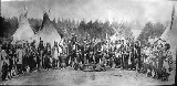
The Flathead Indian Reservation, located in western Montana
Montana
Montana is a state in the Western United States. The western third of Montana contains numerous mountain ranges. Smaller, "island ranges" are found in the central third of the state, for a total of 77 named ranges of the Rocky Mountains. This geographical fact is reflected in the state's name,...
on the Flathead River
Flathead River
The Flathead River, in the northwestern part of the U.S. state of Montana, originates in the Rocky Mountains near Glacier National Park and flows southwest into Flathead Lake, then after a journey of , empties into the Clark Fork. The river is part of the Columbia River drainage basin, as the Clark...
, is home to the Bitterroot Salish
Bitterroot Salish (tribe)
The Bitterroot Salish are one of three tribes of the Confederated Salish and Kootenai Tribes of the Flathead Nation in Montana. The Flathead Reservation is home to the Kootenai and Pend d'Oreilles tribes also.-Language:...
, Kootenai
Kootenai (tribe)
The Ktunaxa , also known as Kootenai, Kutenai or Kootenay , are an indigenous people of North America. They are one of three tribes of the Confederated Salish and Kootenai Tribes of the Flathead Nation in Montana, and they form the Ktunaxa Nation in British Columbia...
, and Pend d'Oreilles
Pend d'Oreilles (tribe)
The Pend d'Oreilles, also known as the Kalispel, are a tribe of Native Americans who lived around Lake Pend Oreille, as well as the Pend Oreille River, and Priest Lake although some of them live spread throughout Montana and eastern Washington...
Tribes - also known as the
Confederated Salish and Kootenai Tribes of the Flathead Nation
Confederated Salish and Kootenai Tribes of the Flathead Nation
The Confederated Salish and Kootenai Tribes of the Flathead Reservation are the Bitterroot Salish, Kootenai and Pend d'Oreilles Tribes. The Flatheads lived between the Cascade Mountains and Rocky Mountains. The Salish initially lived entirely east of the Continental Divide but established their...
. The reservation was created through the July 16, 1855, Treaty of Hellgate
Treaty of Hellgate
The Treaty of Hellgate was signed in Hellgate on July 16, 1855 between Indian commissioner Isaac Stevens and the Native American tribes located in western Montana. The treaty was ratified by Congress, signed by President James Buchanan, and proclaimed on April 18, 1859.The tribes involved in the...
and includes parts of four Montana counties: Lake
Lake County, Montana
-National protected areas:*Flathead National Forest *National Bison Range *Ninepipe National Wildlife Refuge*Pablo National Wildlife Refuge*Swan River National Wildlife Refuge-Demographics:...
, Sanders
Sanders County, Montana
Sanders County is a county located in the U.S. state of Montana. As of 2010, the population was 11,413. Its county seat is Thompson Falls.-Geography:According to the U.S...
, Missoula
Missoula County, Montana
-National protected areas:*Bitterroot National Forest *Flathead National Forest *Lolo National Forest *Rattlesnake National Recreation Area-Demographics:...
, and Flathead
Flathead County, Montana
-National protected areas:* Pacific Northwest National Scenic Trail * Flathead National Forest * Glacier National Park * Kootenai National Forest * Lolo National Forest * Lost Trail National Wildlife Refuge-Demographics:...
. The Flathead Indian Reservation is an area of 1938 square miles (5,019.4 km²) (1317000 acres (532,971.5 ha)) of forested mountains and valleys just west of the Continental Divide
Continental Divide
The Continental Divide of the Americas, or merely the Continental Gulf of Division or Great Divide, is the name given to the principal, and largely mountainous, hydrological divide of the Americas that separates the watersheds that drain into the Pacific Ocean from those river systems that drain...
.
The Bitteroot Salish migrated from the West and share similar language with coastal Salish tribes.