

Great Recycling and Northern Development Canal
Encyclopedia
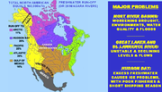
.jpg)
Water management
Water management is the activity of planning, developing, distributing and managing the optimum use of water resources. In an ideal world. water management planning has regard to all the competing demands for water and seeks to allocate water on an equitable basis to satisfy all uses and demands...
proposal designed by Newfoundland
Newfoundland and Labrador
Newfoundland and Labrador is the easternmost province of Canada. Situated in the country's Atlantic region, it incorporates the island of Newfoundland and mainland Labrador with a combined area of . As of April 2011, the province's estimated population is 508,400...
engineer Thomas Kierans
Thomas Kierans
Thomas William Kierans, FCSCE, P. Eng. is an engineer and innovator. He is the originator and principal proponent of the Great Recycling and Northern Development Canal or GRAND Canal....
to alleviate North American freshwater
Freshwater
Fresh water is naturally occurring water on the Earth's surface in ice sheets, ice caps, glaciers, bogs, ponds, lakes, rivers and streams, and underground as groundwater in aquifers and underground streams. Fresh water is generally characterized by having low concentrations of dissolved salts and...
shortage problems
Water politics
Water politics, sometimes called hydropolitics, is politics affected by the availability of water and water resources, a necessity for all life forms and human development...
. The GCNA, which relies upon water management technologies used in the Zuider Zee
Zuider Zee
The Zuiderzee was a shallow bay of the North Sea in the northwest of the Netherlands, extending about 100 km inland and at most 50 km wide, with an overall depth of about 4 to 5 metres and a coastline of about 300 km . It covered...
/ IJsselmeer
IJsselmeer
IJsselmeer is a shallow artificial lake of 1100 km² in the central Netherlands bordering the provinces of Flevoland, North Holland and Friesland, with an average depth of 5 to 6 m. The IJsselmeer is the largest lake in Western Europe....
and California Aqueduct
California Aqueduct
The Governor Edmund G. Brown California Aqueduct is a system of canals, tunnels, and pipelines that conveys water collected from the Sierra Nevada Mountains and valleys of Northern- and Central California to Southern California. The Department of Water Resources operates and maintains the...
, has been promoted by Kierans since 1959.
This plan arose as water quality issues
Great Lakes Areas of Concern
Great Lakes Areas of Concern are designated geographic areas within the Great Lakes Basin that show severe environmental degradation. There are a total of 43 areas of concern within the Great Lakes, 26 being in the U.S., 17 in Canada, with five shared by the two countries.The Great Lakes, the...
threatened the Great Lakes
Great Lakes
The Great Lakes are a collection of freshwater lakes located in northeastern North America, on the Canada – United States border. Consisting of Lakes Superior, Michigan, Huron, Erie, and Ontario, they form the largest group of freshwater lakes on Earth by total surface, coming in second by volume...
and other vital areas in Canada
Canada
Canada is a North American country consisting of ten provinces and three territories. Located in the northern part of the continent, it extends from the Atlantic Ocean in the east to the Pacific Ocean in the west, and northward into the Arctic Ocean...
and the United States
United States
The United States of America is a federal constitutional republic comprising fifty states and a federal district...
. Kierans proposes that to avoid a water crisis
Water crisis
Water crisis is a general term used to describe a situation where the available water within a region is less than the region's demand. The term has been used to describe the availability of potable water in a variety of regions by the United Nations and other world organizations...
from future droughts in Canada and the United States, in addition to water conservation
Water conservation
Water conservation refers to reducing the usage of water and recycling of waste water for different purposes such as cleaning, manufacturing, and agricultural irrigation.- Water conservation :Water conservation can be defined as:...
, acceptable new fresh water sources must be found.
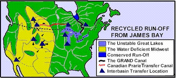
The premise of the GCNA is that fresh water run-off from natural precipitation
Precipitation (meteorology)
In meteorology, precipitation In meteorology, precipitation In meteorology, precipitation (also known as one of the classes of hydrometeors, which are atmospheric water phenomena is any product of the condensation of atmospheric water vapor that falls under gravity. The main forms of precipitation...
will be collected in James Bay by means of a series of outflow-only, sea level dikes-constructed across the northern end of James Bay
James Bay
James Bay is a large body of water on the southern end of Hudson Bay in Canada. Both bodies of water extend from the Arctic Ocean. James Bay borders the provinces of Quebec and Ontario; islands within the bay are part of Nunavut...
. These dikes will capture the fresh water before it mixes with the salty water of Hudson Bay and create a new source of fresh water the equivalent of 2.5 times the flow over Niagara Falls for Canada and the United States. In the second phase of the GRAND Canal proposal a percentage of the captured fresh water run-off would be transferred from the new freshwater reservoir in James Bay by a series of canals and pumping stations south to the Great Lakes. Once in the Great Lakes the new fresh water will be available to stabilize water levels in the Great Lakes/St. Lawrence water basin and to be transferred by natural and man made canals and pumping stations to water deficit areas of Canada and the United States.
In US/Canada sixty percent of precipitation run-off occurs in Canada, which has only 10% of the total population of both nations.
Background
In 1959, Canada officially claimed that U.S. expansion of a Chicago diversionChicago Sanitary and Ship Canal
The Chicago Sanitary and Ship Canal, historically known as the Chicago Drainage Canal, is the only shipping link between the Great Lakes and the Mississippi River system, by way of the Illinois and Des Plaines Rivers...
from Lake Michigan
Lake Michigan
Lake Michigan is one of the five Great Lakes of North America and the only one located entirely within the United States. It is the second largest of the Great Lakes by volume and the third largest by surface area, after Lake Superior and Lake Huron...
would harm downstream Canadian areas in the Great Lakes Basin.
The Canadian government further stated that exhaustive studies had indicated no additional sources of freshwater were available in Canada to replace the waters that would be removed from the Great Lakes by the proposed diversion. Kierans refuted the accuracy of the 1959 Canadian government's position and asserted that the GRAND Canal could provide additional fresh water to the Great Lakes.
Waters from the Ogoki River
Ogoki River
The Ogoki River is a river in the Thunder Bay and Cochrane Districts of Ontario.The river flows northeast from lakes west of Lake Nipigon to Ogoki, where it joins the Albany River which empties into James Bay. The river is 480 km in length...
and Longlac are now being diverted into the Great Lakes at a rate equivalent to that taken by the U.S. at the Chicago diversion.
Similar projects
The NetherlandsNetherlands
The Netherlands is a constituent country of the Kingdom of the Netherlands, located mainly in North-West Europe and with several islands in the Caribbean. Mainland Netherlands borders the North Sea to the north and west, Belgium to the south, and Germany to the east, and shares maritime borders...
has recycled run-off precipitation since 1928 from a sea level, outflow-only, multi-use, freshwater dyke-enclosure in the former Zuider Zee
Zuider Zee
The Zuiderzee was a shallow bay of the North Sea in the northwest of the Netherlands, extending about 100 km inland and at most 50 km wide, with an overall depth of about 4 to 5 metres and a coastline of about 300 km . It covered...
Sea and newly created IJsselmeer
IJsselmeer
IJsselmeer is a shallow artificial lake of 1100 km² in the central Netherlands bordering the provinces of Flevoland, North Holland and Friesland, with an average depth of 5 to 6 m. The IJsselmeer is the largest lake in Western Europe....
fresh water lake. For 50 years, an expanding California Aqueduct
California Aqueduct
The Governor Edmund G. Brown California Aqueduct is a system of canals, tunnels, and pipelines that conveys water collected from the Sierra Nevada Mountains and valleys of Northern- and Central California to Southern California. The Department of Water Resources operates and maintains the...
with a 1200 m pump-lift, has recycled up to 115 m3/sec of northern river run-off from upstream of the sea in San Francisco Bay
San Francisco Bay
San Francisco Bay is a shallow, productive estuary through which water draining from approximately forty percent of California, flowing in the Sacramento and San Joaquin rivers from the Sierra Nevada mountains, enters the Pacific Ocean...
over 700 km southward in the San Joaquin River
San Joaquin River
The San Joaquin River is the largest river of Central California in the United States. At over long, the river starts in the high Sierra Nevada, and flows through a rich agricultural region known as the San Joaquin Valley before reaching Suisun Bay, San Francisco Bay, and the Pacific Ocean...
valley. This recycled fresh water has been used to create productive new farm and urban areas in former arid land. New recycled run-off proposals are now being considered throughout the world.
Another North America-wide proposal is the North American Water and Power Alliance
North American Water and Power Alliance
The North American Water and Power Alliance was conceived in the 1950s by the US Army Corps of Engineers as a 'Great Project' to develop more water sources for the United States...
(NAWAPA) proposal, which would divert waters from rivers draining into the Pacific Ocean
Pacific Ocean
The Pacific Ocean is the largest of the Earth's oceanic divisions. It extends from the Arctic in the north to the Southern Ocean in the south, bounded by Asia and Australia in the west, and the Americas in the east.At 165.2 million square kilometres in area, this largest division of the World...
.
See also Siberian river reversal.
Proposal
James Bay
James Bay is a large body of water on the southern end of Hudson Bay in Canada. Both bodies of water extend from the Arctic Ocean. James Bay borders the provinces of Quebec and Ontario; islands within the bay are part of Nunavut...
by collecting run-off from many adjacent river basins in a sea level, outflow-only dyke-enclosure. The project would capture and make available for recycling the entire outflows of the La Grande
La Grande River
La Grande River is a river in northwestern Quebec, Canada, which rises in the highlands of north central Quebec and flows roughly west to drain into James Bay. It is the second largest river in Quebec, surpassed only by the Saint Lawrence River....
, Eastmain
Eastmain River
The Eastmain River is a river in northwestern Quebec which rises in north central Quebec and flows 800 km west to drain into James Bay. 'East Main' is an old name for the east side of James Bay. This river drains an area of 46,400 km²...
, Rupert
Rupert River
The Rupert River is one of the largest rivers in Quebec, Canada. From its headwaters in Lake Mistassini, the largest natural lake in Québec, it flows west into Rupert Bay on James Bay. The Rupert drains an area of . There is some extremely large whitewater on the river, but paddlers can avoid...
, Broadback
Broadback River
The Broadback River is a river in northern Quebec, Canada. It drains into Rupert Bay , just south of the Rupert River and Cree community Waskaganish...
, Nottaway
Nottaway River
The Nottaway River is a river in Quebec, Canada. The river drains Lake Matagami and travels north-west before emptying into Rupert Bay at the south end of James Bay. Its drainage basin is and has a mean discharge of 1190 m³/s...
, Harricana
Harricana River
The Harricana River is a river in western Quebec and northeastern Ontario, Canada. It is long, has a drainage area of , and has a mean discharge of 570 m³/s...
, Moose
Moose River (Ontario)
The Moose River is a Canadian river in the Hudson Plains ecozone of northern Ontario which flows 100 km northeast from the junction of the Mattagami and Missinaibi Rivers into James Bay. Its drainage basin is 108,500 km² and it has a mean discharge rate of 1370 m³/s. Its full length...
, Albany
Albany River
The Albany River is a river in Northern Ontario, Canada, which flows northeast from Lake St. Joseph in Northwestern Ontario and empties into James Bay. It is long to the head of the Cat River, tying it with the Severn River for the title of longest river in Ontario...
, Kapiskau, Attawapiskat
Attawapiskat River
The Attawapiskat River is a river in Kenora District in northwestern Ontario, Canada that flows east from Attawapiskat Lake to James Bay.-Course:The Attawapiskat River travels a distance of , and has a drainage area of ....
and Ekawan rivers.
Moreover, Kierans claims that California’s Aqueduct proves that run-off to James Bay can be beneficially recycled long distances and over high elevations via the GRAND Canal. The GCNA would stabilize water levels in the Great Lakes and St. Lawrence River and improve water quality. The GRAND Canal system would also deliver new fresh water from the James Bay dyke-enclosure, via the Great Lakes, to many water deficit areas in Canada and the United States. The project was estimated in 1994 to cost CA$100 billion to build and a further CA$1 billion annually to operate, involving a string of nuclear reactors and hydroelectric dams to pump water uphill and into other waterbasins.
Benefits / costs
Kierans argues recycling run-off from a dike-enclosure in Canada’s James Bay is not harmful and can bring both nations many useful benefits including:- More fresh water for Canada and the United States to stabilize Great Lakes/St. Lawrence water levels and to relieve water shortages and droughts in western Canada and in the south-west U.S. and in particular to halt the depletion and start the replenishment of the Ogallala AquiferOgallala AquiferThe Ogallala Aquifer, also known as the High Plains Aquifer, is a vast yet shallow underground water table aquifer located beneath the Great Plains in the United States...
(see water exportWater exportWater exports involve exporting freshwater from one country to another. Large increases in human population and economic growth throughout the world during the twentieth century placed a huge stress on the world’s freshwater resources. Combined with climate change, they will place an even greater...
); - Improved fisheries and shipping in Hudson BayHudson BayHudson Bay , sometimes called Hudson's Bay, is a large body of saltwater in northeastern Canada. It drains a very large area, about , that includes parts of Ontario, Quebec, Saskatchewan, Alberta, most of Manitoba, southeastern Nunavut, as well as parts of North Dakota, South Dakota, Minnesota,...
. Oceanographer Professor Max Dunbar pointed out in his paper "Hudson Bay has too much fresh water" that as a result of its low salinity Hudson Bay currently "offers no possibilities for commercial fisheries". By recycling the fresh water run-off from James Bay south to the Great Lakes and away from Hudson's Bay the GRAND Canal will increase Hudson Bay’s now harmfully low salinity and consequently improve the commercial fisheries. Increasing the salinity of Hudson Bay will also have the benefit of reducing the freeze-over period during the winter and thereby lengthen the navigation season in Hudson Bay; - Improved Great Lakes water quality due to the increased flows;
- Increased electricity available for alternate uses and lowered user cost of electricity by integrating water transfer energy needs with peak power demand;
- Enhanced flood controls; and
- Improved forest fire protection for both nations>.
- The construction and operation of the GCNA would provide economic stimulus to create employment and avoid recession. This would be similar to the economic stimulus that the Tennessee Valley AuthorityTennessee Valley AuthorityThe Tennessee Valley Authority is a federally owned corporation in the United States created by congressional charter in May 1933 to provide navigation, flood control, electricity generation, fertilizer manufacturing, and economic development in the Tennessee Valley, a region particularly affected...
development and other public works had in the 1930s to start the recovery from the Great DepressionGreat DepressionThe Great Depression was a severe worldwide economic depression in the decade preceding World War II. The timing of the Great Depression varied across nations, but in most countries it started in about 1929 and lasted until the late 1930s or early 1940s...
.
According to Kierans, project organization to recycle run-off from James Bay Basin could be like that for the St. Lawrence Seaway. Capital costs for about 160 million users will exceed $100 billion. But, he claims, “before construction is completed, the total value of social, ecologic and economic benefits in Canada and the U.S. will surpass the project’s costs.”
Developments
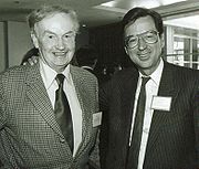
The GRAND Canal proposal attracted the attention of former Québec premier Robert BourassaRobert Bourassa
Jean-Robert Bourassa, was a politician in Quebec, Canada. He served as the 22nd Premier of Quebec in two different mandates, first from May 12, 1970, to November 25, 1976, and then from December 12, 1985, to January 11, 1994, serving a total of just under 15 years as Provincial Premier.-Early...
and former Prime Minister of Canada Brian Mulroney
Brian Mulroney
Martin Brian Mulroney, was the 18th Prime Minister of Canada from September 17, 1984, to June 25, 1993 and was leader of the Progressive Conservative Party of Canada from 1983 to 1993. His tenure as Prime Minister was marked by the introduction of major economic reforms, such as the Canada-U.S...
. By 1985, Bourassa and several major engineering companies endorsed detailed GRAND Canal concept studies.. However these concept studies have not proceeded because, as Kierans says: "...some misinformed environmentalists and news media refuse to accept the proven Netherlands and California recycled run-off projects. Further, they refuse to acknowledge the fundamental differences between NAWAPA's (North American Water and Power Alliance
North American Water and Power Alliance
The North American Water and Power Alliance was conceived in the 1950s by the US Army Corps of Engineers as a 'Great Project' to develop more water sources for the United States...
) harmful 'headwater diversion' and the environmentally friendly 'recycled run-off' of the GRAND Canal (see map and table below and Cadillac Desert
Cadillac Desert
Cadillac Desert, by Marc Reisner, is a 1986 book published by Viking about land development and water policy in the western United States. Subtitled The American West and its Disappearing Water, it gives the history of the Bureau of Reclamation and U.S. Army Corps of Engineers, and their struggle...
). Unfortunately, their political influence continues to block Canadian government support for the urgently needed detailed studies of recycled run-off from James Bay. Until the Canadian Government supports such studies, drought and freshwater quality in Canada and the U.S. will continue to worsen”

Recycling vs. Diversion
Below are two maps showing the contrasting North American drought relief proposals: on the left the GRAND Canal Proposal and on the right the NAWAPA Plan.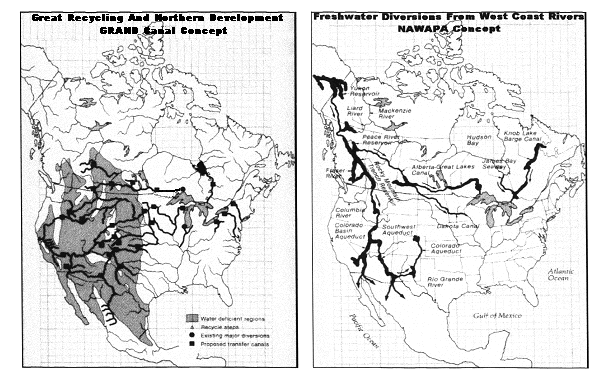
With the NAWAPA diversionary plan no new fresh water will be added to the system. NAWAPA proposes to dam mostly Canadian rivers to create massive new reservoirs and then divert the water to drought afflicted regions mostly in the American South-west. Only existing sources of fresh water will be collected and redirected. By necessity and by plan NAWAPA will deprive some areas (mostly in Canada) that now have water and flood other areas for reservoirs (also mostly in Canada) where at the present time no water flows. The ultimate recipients of the NAWAPA water will for the most part be in the American South-west. Aside from being tremendously expensive to build and operate, NAWAPA will have massive and yet to be determined environmental impacts. Abundant animal and vegetable life will be damaged and destroyed. Populations of human and other species will have to be relocated.
The GRAND Canal proposes no such flooding or diversion. The new water will collected in existing reservoirs (James Bay and the Great Lakes) and flow along existing or new man made and environmentally friendly waterways to existing reservoirs or aquifers. Nature will be respected and environmental impacts will be kept to a minimum.
Below is a table that, according to Kierans, compares the two proposals.
| The GRAND Canal | NAWAPA |
|---|---|
| 1. Basic proposal: Recycling of fresh water at point where it would otherwise be lost to Hudson Bay/Arctic Ocean. New source of fresh water 2.5 X Niagara Falls transferred to American South-west and Canadian West. | 1. Basic Proposal: Damming and diverting existing rivers from Alaska and Northern Canada to the American South-west. No new water source created. |
| 2. Use of existing reservoirs (James Bay, Great Lakes) No flooding to create new reservoirs. | 2. Massive flooding of mountain valleys to create new reservoirs. Displacement of populations. |
| 3. No diverting of water away from where it now flows. | 3. Massive diversion and rerouting of rivers. Downstream locations deprived of water. |
| 4. Cost: 100 Billion repaid in 2 years. Cost of pumping water offset by peak power sales. As with the St. Lawrence Seaway each country pays for part of construction on its own soil. | 4. Cost: Enormous. Impossible to accurately estimate. Would required revamping of economy. Complex sharing of cost arrangements between Canada and U.S. necessary. |
| 5. Technology (see Zuider Zee and the California Aqueduct) existing for over a hundred years. Construction could start tomorrow. | 5. Technology. The size and complexity of the scheme makes the project many years away from being realizable. Delay of drought solution costly |
| 6. Canada/US International Agreement: Simple scheme whereby Canada sells water from the newly created source and a renewable natural resource, to the United States for agreed upon price. Similar to the sale of electrical energy. | 6. Canada/US International Agreement: Very complex and unclear how Canada will be compensated for its water (if at all) most of which will be shipped to the South-western states. Negotiations could take decades. |
| 7. Precedents. Many precedents, including NORAD and St Lawrence Seaway, of this type of Canada/US co-operation. | 7. Precedents. No precedents for this type of co-operation where one country suffers environmentally for the almost exclusive benefit of the other. |
Environmental concerns
- Later ice formation, and earlier ice breakup outside the dike corresponding to an opposite change in the fresh waters inside;
- Diminished ecological productivity, possibly as far away as the Labrador SeaLabrador SeaThe Labrador Sea is an arm of the North Atlantic Ocean between the Labrador Peninsula and Greenland. The sea is flanked by continental shelves to the southwest, northwest, and northeast. It connects to the north with Baffin Bay through the Davis Strait...
; - Fewer nutrients being deposited into Hudson Bay during spring melts;
- Removal of James Bay's dampening effect on tidal and wind disturbances; and
- Adversely affected migratory bird populations
The reduced freshwater flow into Hudson Bay will alter the salinity and stratification of the bay, possibly impacting primary production
Primary production
400px|thumb|Global oceanic and terrestrial photoautotroph abundance, from September [[1997]] to August 2000. As an estimate of autotroph biomass, it is only a rough indicator of primary production potential, and not an actual estimate of it...
in Hudson Bay, along the Labrador
Labrador
Labrador is the distinct, northerly region of the Canadian province of Newfoundland and Labrador. It comprises the mainland portion of the province, separated from the island of Newfoundland by the Strait of Belle Isle...
coast, and as far away as the fishing grounds in the Grand Banks of Newfoundland, the Scotian Shelf, and Georges Bank
Georges Bank
Georges Bank is a large elevated area of the sea floor which separates the Gulf of Maine from the Atlantic Ocean and is situated between Cape Cod, Massachusetts and Cape Sable Island, Nova Scotia ....
.
If the James Bay dike is built, "[v]irtually all marine organisms would be destroyed [in the newly formed lake]". Freshwater species would move in, but northern reservoirs tend to fail to produce viable fisheries.
The inter-basin connections would be ideal vectors for invasive species
Invasive species
"Invasive species", or invasive exotics, is a nomenclature term and categorization phrase used for flora and fauna, and for specific restoration-preservation processes in native habitats, with several definitions....
to invade new waters.
The construction of a dike across James Bay could negatively impact many mammal species, including ringed
Ringed Seal
The ringed seal , also known as the jar seal and as netsik or nattiq by the Inuit, is an earless seal inhabiting the Arctic and sub-Arctic regions...
and bearded seal
Bearded Seal
The bearded seal , also called the square flipper seal, is a medium-sized pinniped that is found in and near to the Arctic Ocean. It gets its generic name from two Greek words that refer to its heavy jaw...
s, walrus
Walrus
The walrus is a large flippered marine mammal with a discontinuous circumpolar distribution in the Arctic Ocean and sub-Arctic seas of the Northern Hemisphere. The walrus is the only living species in the Odobenidae family and Odobenus genus. It is subdivided into three subspecies: the Atlantic...
es, and bowhead whale
Bowhead Whale
The bowhead whale is a baleen whale of the right whale family Balaenidae in suborder Mysticeti. A stocky dark-colored whale without a dorsal fin, it can grow to in length. This thick-bodied species can weigh to , second only to the blue whale, although the bowhead's maximum length is less than...
s, as well as vulnerable populations of polar bear
Polar Bear
The polar bear is a bear native largely within the Arctic Circle encompassing the Arctic Ocean, its surrounding seas and surrounding land masses. It is the world's largest land carnivore and also the largest bear, together with the omnivorous Kodiak Bear, which is approximately the same size...
s and beluga whales. The impacts would also affect many species of migratory bird, including lesser snow geese
Snow Goose
The Snow Goose , also known as the Blue Goose, is a North American species of goose. Its name derives from the typically white plumage. The genus of this bird is disputed...
, Canada geese
Canada Goose
The Canada Goose is a wild goose belonging to the genus Branta, which is native to arctic and temperate regions of North America, having a black head and neck, white patches on the face, and a brownish-gray body....
, black scoter
Black Scoter
The Black or American Scoter is a large sea duck, 43 to 49 centimeters in length. Together with the Common Scoter M. nigra, it forms the subgenus Oidemia; the two are sometimes considered conspecific, the Black Scoter then being referred to as M. nigra americana...
s, brant
Brent Goose
The Brant or Brent Goose, Branta bernicla, is a species of goose of the genus Branta. The Black Brant is an American subspecies. The specific descriptor bernicla is from the same source as "barnacle" in Barnacle Goose, which looks similar but is not a close relation.-Appearance:The Brant Goose is...
s, American black duck
American Black Duck
The American Black Duck is a large dabbling duck. American Black Ducks are similar to Mallards in size, and resemble the female Mallard in coloration, although the Black Duck's plumage is darker...
s, northern pintail
Northern Pintail
The Pintail or Northern Pintail is a widely occurring duck which breeds in the northern areas of Europe, Asia and North America. It is strongly migratory and winters south of its breeding range to the equator...
s, mallard
Mallard
The Mallard , or Wild Duck , is a dabbling duck which breeds throughout the temperate and subtropical Americas, Europe, Asia, and North Africa, and has been introduced to New Zealand and Australia....
s, American wigeon
American Wigeon
The American Wigeon, also American Widgeon or Baldpate, is a species of wigeon in the dabbling duck genus Anas. If this is split up, all wigeons will go into their old genus Mareca again...
s, Green-winged teal
Green-winged Teal
The Green-winged Teal is a common and widespread duck that breeds in the northern areas of North America except on the Aleutian Islands. It was considered conspecific with the Common Teal The Green-winged Teal (Anas carolinensis) is a common and widespread duck that breeds in the northern areas of...
s, greater scaup
Greater Scaup
The Greater Scaup , just Scaup in Europe, or colloquially known as "Bluebill", for its bright blue bill, is small compared to other diving ducks, however it is larger than the closely related Lesser Scaup...
s, common eider
Common Eider
The Common Eider, Somateria mollissima, is a large sea-duck that is distributed over the northern coasts of Europe, North America and eastern Siberia. It breeds in Arctic and some northern temperate regions, but winters somewhat farther south in temperate zones, when it can form large flocks on...
s, red knot
Red Knot
The Red Knot, Calidris canutus , is a medium sized shorebird which breeds in tundra and the Arctic Cordillera in the far north of Canada, Europe, and Russia. It is a large member of the Calidris sandpipers, second only to the Great Knot...
s, dunlin
Dunlin
The Dunlin, Calidris alpina, is a small wader, sometimes separated with the other "stints" in Erolia. It is a circumpolar breeder in Arctic or subarctic regions. Birds that breed in northern Europe and Asia are long-distance migrants, wintering south to Africa, southeast Asia and the Middle East...
s, black-bellied, American golden
American Golden Plover
The American Golden Plover is a medium-sized plover.Adults are spotted gold and black on the crown, back and wings. Their face and neck are black with a white border; they have a black breast and a dark rump. The legs are black....
s, and semipalmated plover
Semipalmated Plover
The Semipalmated Plover is a small plover.This species weighs and measures in length and across the wings. Adults have a grey-brown back and wings, a white belly, and a white breast with one black neckband...
s, greater
Greater Yellowlegs
The Greater Yellowlegs, Tringa melanoleuca, is a large North American shorebird, similar in appearance to the smaller Lesser Yellowlegs. Its closest relative, however, is the Greenshank, which together with the Spotted Redshank form a close-knit group...
and lesser yellowlegs
Lesser Yellowlegs
The Lesser Yellowlegs is a medium-sized shorebird similar in appearance to the larger Greater Yellowlegs. It is not closely related to this bird, however, but instead to the much larger and quite dissimilar Willet; merely the fine, clear and dense pattern of the neck shown in breeding plumage...
, sanderling
Sanderling
The Sanderling is a small wader. It is a circumpolar Arctic breeder, and is a long-distance migrant, wintering south to South America, South Europe, Africa, and Australia...
s, many species of sandpipers, whimbrel
Whimbrel
The Whimbrel Numenius phaeopus, is a wader in the large family Scolopacidae. It is one of the mostwidespread of the curlews, breeding across much of subarctic North America, Europe and Asia as far south as Scotland....
s, and marbled godwit
Marbled Godwit
The Marbled Godwit, Limosa fedoa, is a large shorebird. On average, it is the largest of the 4 species of godwit. The total length is , including a large bill of , and wingspan is . Body mass can vary from ....
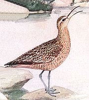
s, as well as the critically endangered Eskimo curlew
Eskimo Curlew
The Eskimo or the "Northern Curlew" is a critically endangered shorebird, now considered by many to be extinct.-Taxonomy:The Eskimo Curlew is one of eight species of curlew, and is classed with them in the genus Numenius. It was formerly placed in the separate genus Mesoscolopax. Numenius is...
.
Social concerns
The project is expected to cost CA$100 billion to implement, and a further CA$1 billion a year to operate. Most of the water diverted would be exported to the US.In addition, the shoreline communities of Attawapiskat, Kashechewan, Fort Albany
Fort Albany, Ontario
Fort Albany First Nation is a community in within the Cochrane District of Northern Ontario, Canada. Situated on the southern shore of the Albany River, Fort Albany First Nation is only accessible by air or by winter road....
, Moosonee
Moosonee, Ontario
Moosonee is a town in northern Ontario, Canada, on the Moose River approximately south of James Bay. It is considered as "the Gateway to the Arctic" and has Ontario's only saltwater port...
, Moose Factory
Moose Factory, Ontario
Moose Factory is a community in the Cochrane District, Ontario, Canada. It is on Moose Factory Island, near the mouth of the Moose River, which is at the southern end of James Bay. It was the first English-speaking settlement in Ontario and the second Hudson's Bay Company post to be set up in North...
(Ontario), Waskaganish
Waskaganish, Quebec
Waskaganish is a Cree village of about 2000 people at the mouth of the Rupert River on the south-east shore of James Bay in the Eeyou Istchee territory in Northern Quebec, Canada...
, Eastmain
Eastmain, Quebec
Eastmain is a Cree community located on James Bay at the mouth of the Eastmain River, Quebec, Canada. It is the smallest of the coastal Cree villages with a population of 606 people...
, Wemindji
Wemindji, Quebec
Wemindji is a small Cree community on Paint Hills Bay off James Bay at the mouth of the Maquatua River in Quebec, Canada. The community has a population of 1238 people ....
and Chisasibi
Chisasibi, Quebec
Chisasibi is a village on the eastern shore of James Bay, in the Eeyou Istchee territory in northern Quebec, Canada. It is situated on the south shore of La Grande River , less than from the river's mouth...
(Québec) would be forced to relocate.
Conspiracy theory
In the 1990s, Canadian conspiracy theorists believed the "GRAND Canal" was part of a conspiracy to end Canadian sovereignty and force it into a union with the USA and Mexico. Conspiracy theorists believed forces interested in North American union would agitate for a Quebec separation, which would then touch off a Canadian civil war and plunge the Canadian economy into a depression. Impoverished Canadians would then look to the canal project and North American union to revitalize the Canadian economy. Much of the scenario was lifted from Lansing Lamont's 1994 book Breakup: The Coming End of Canada and the Stakes for America.Allegedly masterminding this conspiracy was Simon Reisman
Simon Reisman
Sol Simon Reisman, was a Canadian civil servant, and the country's chief negotiator for the Canada-United States Free Trade Agreement....
, ostensibly a Freemason.
External links
- * A Brief History of the Great Recycling and Northern Development (GRAND) Canal Project, Undercurrents
- GRAND Canal official website
- Hunter, David (1992) Interbasin water transfers after NAFTA: Is water a commodity or ecological resource? Center for International Environmental Law
- Milko, Robert (1986, December). Potential ecological effects of the proposed GRAND Canal diversion project on Hudson and James Bays. Arctic, 39(4): 316-325.
- Thomas Kierans ZoomInfo Bio
- Video interview of Thomas Kierans post on Globe and Mail web site.