
.gif)
Hurricane Danielle (1998)
Encyclopedia
Hurricane Danielle was the fourth named storm
, second hurricane, and fourth most intense storm of the active 1998 Atlantic hurricane season
, and was a long-tracking Cape Verde-type hurricane
across the Atlantic Ocean
that originated off the Africa
n coastline on August 21, reaching its peak intensity of 105 mph (170 km/h) four times periodically in its track across the Atlantic. Following just days behind Hurricane Bonnie
, Danielle remained offshore, although it came close to the continental United States. Although it did not make landfall or have significant impact on land as a hurricane, Danielle had a serious impact on the British Isles
as an extratropical cyclone on September 6, where it caused significant erosion and high seas shortly before merging with another extratropical low near Ireland
, resulting in the rescue of several people from difficult sea conditions and the evacuation of coastal beach areas in some places, including Cornwall
. Fortunately, little damage was associated from the remnants of Danielle in the coastal British Isles. Aside from the British Isles, Danielle also delivered tropical storm-force winds to Bermuda
, although it did little damage.
marked by a persistent west-northwest motion for several days since it first formed, the origins of Danielle have been traced to a tropical wave
that exited the western coast
of Africa
on August 21. Bearing an ill-defined circulation center amid a cyclonic cloud formation, deep convection began to cluster around the circulation within 24 hours, and Dvorak
satellite presentation classifications were issued the following day around 1100 UTC
. Shortly thereafter, convective organization improved as clusters of showers and cloudiness became more concentrated, and later, on August 24, the developing system was upgraded to Tropical Depression Four as the system was approximately 600 miles (965.6 km) west-southwest of Cape Verde
. Organization continued as the system continued to strengthen, and convective activity became more tightly wrapped around the center, and late on August 24, the system was upgraded to the fourth named storm of the season, Tropical Storm Danielle.
Due to well-defined tropospheric outflow, Danielle's intensification trend continued; on August 25, a pinhole-type eye developed, and Danielle was upgraded to a hurricane. The system was quite compact, with tropical storm-force winds extending over an area slightly more than 115 miles (185.1 km). With the small size aiding in further intensification of the well-established hurricane, satellite imagery indicated that Danielle continued to intensify to a first peak intensity of 105 mph (170 km/h) while about 1036 miles (1,667.3 km) east of the Lesser Antilles
on August 26. After reaching its first peak intensity, southeasterly vertical wind shear
disrupted Danielle's organization, and reconnaissance aircraft
data on August 27 indicated that the system was not well-organized. However, despite a relatively high pressure of 993 mbar (29.3 inHg), the storm continued to maintain its intensity of 105 mph (170 km/h). This deviation from the wind-pressure relationship was probably due to the storm's small size.
Significant further strengthening of Danielle continued to be hampered by moderate vertical shear, but the storm managed to gain a second 105 mph (170 km/h) peak indicated by aircraft data later on August 27. Afterwards, some weakening took place over the next few days, and the storm was barely a hurricane by August 30, likely due to the cool wake left by Hurricane Bonnie
just days earlier.
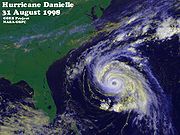
Danielle's persistent west-northwest motion continued as it neared the western periphery of the subtropical ridge
on August 30, where it began to slow in speed. Continuing to lose speed, a turn to the northwest and north began, reaching its westernmost point on August 31. Reaching its third 105 mph (170 km/h) peak intensity, Danielle completed recurvature, and southwesterly flow ahead of an approaching trough off the eastern United States coastline began to accelerate Danielle northeast on September 1, briefly reaching a fourth and final peak intensity of 105 mph (170 km/h). After passing 230 miles (370.1 km) northwest of Bermuda
the next day, Danielle began to lose tropical characteristics as the storm was centered approximately 230 miles (370.1 km) south of Cape Race, Newfoundland
, still bearing hurricane-force winds. Danielle became an extratropical cyclone on September 4, then continued to move east to east-northeast across the Atlantic for the next two days, with gradual weakening taking place. It slowed in speed and turned northeast on September 6 while 345 miles (555.2 km) west of the British Isles, losing identity on September 8 while merging with another extratropical cyclone 230 miles (370.1 km) north of Iceland
.
 At 1500 UTC on September 1, a tropical storm warning was issued for Bermuda, as the storm was considered a likely threat to the island. Elsewhere, tropical cyclone advisories were not required. The storm was generally well-forecast by the National Hurricane Center
, with a low degree of errors compared to average; therefore, the storm's recurvature away from land was anticipated well in advance. Along the U.S. East Coast, Danielle's effects were minimal, though sustained winds of 40 mph (64.4 km/h), along with gusts to 54 mph (86.9 km/h), were recorded on Bermuda.
While passing near the British Isles
on September 6 as an extratropical storm, Danielle delivered severe sea conditions to the western part of the isles. Erosion became a problem in some areas, and many people were rescued from rough seas. Coast
al portions of Cornwall
were evacuated as high waves broke over the tops of homes, and an all-terrain police vehicle was shoved into the sea by a rogue wave in the Isles of Scilly
. No direct deaths, however, occurred in the British Isles, and no significant damage was reported.
Tropical cyclone
A tropical cyclone is a storm system characterized by a large low-pressure center and numerous thunderstorms that produce strong winds and heavy rain. Tropical cyclones strengthen when water evaporated from the ocean is released as the saturated air rises, resulting in condensation of water vapor...
, second hurricane, and fourth most intense storm of the active 1998 Atlantic hurricane season
1998 Atlantic hurricane season
The 1998 Atlantic hurricane season officially began on June 1, 1998, and lasted until November 30, 1998. These dates conventionally delimit the period of each year when most tropical cyclones form in the Atlantic basin; however, the season extended through December 1 as Hurricane Nicole remained...
, and was a long-tracking Cape Verde-type hurricane
Cape Verde-type hurricane
A Cape Verde-type hurricane is an Atlantic hurricane that develops near the Cape Verde islands, off the west coast of Africa. The average hurricane season has about two Cape Verde-type hurricanes, which are usually the largest and most intense storms of the season because they often have plenty of...
across the Atlantic Ocean
Atlantic Ocean
The Atlantic Ocean is the second-largest of the world's oceanic divisions. With a total area of about , it covers approximately 20% of the Earth's surface and about 26% of its water surface area...
that originated off the Africa
Africa
Africa is the world's second largest and second most populous continent, after Asia. At about 30.2 million km² including adjacent islands, it covers 6% of the Earth's total surface area and 20.4% of the total land area...
n coastline on August 21, reaching its peak intensity of 105 mph (170 km/h) four times periodically in its track across the Atlantic. Following just days behind Hurricane Bonnie
Hurricane Bonnie (1998)
Hurricane Bonnie was a major hurricane that made landfall in North Carolina, United States, inflicting severe crop damage. The second named storm, first hurricane, and first major hurricane of the 1998 Atlantic hurricane season, Bonnie developed from a tropical wave that emerged off the coast of...
, Danielle remained offshore, although it came close to the continental United States. Although it did not make landfall or have significant impact on land as a hurricane, Danielle had a serious impact on the British Isles
British Isles
The British Isles are a group of islands off the northwest coast of continental Europe that include the islands of Great Britain and Ireland and over six thousand smaller isles. There are two sovereign states located on the islands: the United Kingdom of Great Britain and Northern Ireland and...
as an extratropical cyclone on September 6, where it caused significant erosion and high seas shortly before merging with another extratropical low near Ireland
Ireland
Ireland is an island to the northwest of continental Europe. It is the third-largest island in Europe and the twentieth-largest island on Earth...
, resulting in the rescue of several people from difficult sea conditions and the evacuation of coastal beach areas in some places, including Cornwall
Cornwall
Cornwall is a unitary authority and ceremonial county of England, within the United Kingdom. It is bordered to the north and west by the Celtic Sea, to the south by the English Channel, and to the east by the county of Devon, over the River Tamar. Cornwall has a population of , and covers an area of...
. Fortunately, little damage was associated from the remnants of Danielle in the coastal British Isles. Aside from the British Isles, Danielle also delivered tropical storm-force winds to Bermuda
Bermuda
Bermuda is a British overseas territory in the North Atlantic Ocean. Located off the east coast of the United States, its nearest landmass is Cape Hatteras, North Carolina, about to the west-northwest. It is about south of Halifax, Nova Scotia, Canada, and northeast of Miami, Florida...
, although it did little damage.
Meteorological history
A Cape Verde-type hurricaneCape Verde-type hurricane
A Cape Verde-type hurricane is an Atlantic hurricane that develops near the Cape Verde islands, off the west coast of Africa. The average hurricane season has about two Cape Verde-type hurricanes, which are usually the largest and most intense storms of the season because they often have plenty of...
marked by a persistent west-northwest motion for several days since it first formed, the origins of Danielle have been traced to a tropical wave
Tropical wave
Tropical waves, easterly waves, or tropical easterly waves, also known as African easterly waves in the Atlantic region, are a type of atmospheric trough, an elongated area of relatively low air pressure, oriented north to south, which move from east to west across the tropics causing areas of...
that exited the western coast
Coast
A coastline or seashore is the area where land meets the sea or ocean. A precise line that can be called a coastline cannot be determined due to the dynamic nature of tides. The term "coastal zone" can be used instead, which is a spatial zone where interaction of the sea and land processes occurs...
of Africa
Africa
Africa is the world's second largest and second most populous continent, after Asia. At about 30.2 million km² including adjacent islands, it covers 6% of the Earth's total surface area and 20.4% of the total land area...
on August 21. Bearing an ill-defined circulation center amid a cyclonic cloud formation, deep convection began to cluster around the circulation within 24 hours, and Dvorak
Dvorak technique
The Dvorak technique is a widely used system to subjectively estimate tropical cyclone intensity based solely on visible and infrared satellite images. Several agencies issue Dvorak intensity numbers for cyclones of sufficient intensity...
satellite presentation classifications were issued the following day around 1100 UTC
Universal Time
Universal Time is a time scale based on the rotation of the Earth. It is a modern continuation of Greenwich Mean Time , i.e., the mean solar time on the Prime Meridian at Greenwich, and GMT is sometimes used loosely as a synonym for UTC...
. Shortly thereafter, convective organization improved as clusters of showers and cloudiness became more concentrated, and later, on August 24, the developing system was upgraded to Tropical Depression Four as the system was approximately 600 miles (965.6 km) west-southwest of Cape Verde
Cape Verde
The Republic of Cape Verde is an island country, spanning an archipelago of 10 islands located in the central Atlantic Ocean, 570 kilometres off the coast of Western Africa...
. Organization continued as the system continued to strengthen, and convective activity became more tightly wrapped around the center, and late on August 24, the system was upgraded to the fourth named storm of the season, Tropical Storm Danielle.
Due to well-defined tropospheric outflow, Danielle's intensification trend continued; on August 25, a pinhole-type eye developed, and Danielle was upgraded to a hurricane. The system was quite compact, with tropical storm-force winds extending over an area slightly more than 115 miles (185.1 km). With the small size aiding in further intensification of the well-established hurricane, satellite imagery indicated that Danielle continued to intensify to a first peak intensity of 105 mph (170 km/h) while about 1036 miles (1,667.3 km) east of the Lesser Antilles
Lesser Antilles
The Lesser Antilles are a long, partly volcanic island arc in the Western Hemisphere. Most of its islands form the eastern boundary of the Caribbean Sea with the Atlantic Ocean, with the remainder located in the southern Caribbean just north of South America...
on August 26. After reaching its first peak intensity, southeasterly vertical wind shear
Wind shear
Wind shear, sometimes referred to as windshear or wind gradient, is a difference in wind speed and direction over a relatively short distance in the atmosphere...
disrupted Danielle's organization, and reconnaissance aircraft
Reconnaissance aircraft
A reconnaissance aircraft is a manned military aircraft designed, or adapted, to carry out aerial reconnaissance.-History:The majority of World War I aircraft were reconnaissance designs...
data on August 27 indicated that the system was not well-organized. However, despite a relatively high pressure of 993 mbar (29.3 inHg), the storm continued to maintain its intensity of 105 mph (170 km/h). This deviation from the wind-pressure relationship was probably due to the storm's small size.
Significant further strengthening of Danielle continued to be hampered by moderate vertical shear, but the storm managed to gain a second 105 mph (170 km/h) peak indicated by aircraft data later on August 27. Afterwards, some weakening took place over the next few days, and the storm was barely a hurricane by August 30, likely due to the cool wake left by Hurricane Bonnie
Hurricane Bonnie (1998)
Hurricane Bonnie was a major hurricane that made landfall in North Carolina, United States, inflicting severe crop damage. The second named storm, first hurricane, and first major hurricane of the 1998 Atlantic hurricane season, Bonnie developed from a tropical wave that emerged off the coast of...
just days earlier.
Danielle's persistent west-northwest motion continued as it neared the western periphery of the subtropical ridge
Subtropical ridge
The subtropical ridge is a significant belt of high pressure situated around the latitudes of 30°N in the Northern Hemisphere and 30°S in the Southern Hemisphere. It is characterized by mostly calm winds, which acts to reduce air quality under its axis by causing fog overnight, and haze during...
on August 30, where it began to slow in speed. Continuing to lose speed, a turn to the northwest and north began, reaching its westernmost point on August 31. Reaching its third 105 mph (170 km/h) peak intensity, Danielle completed recurvature, and southwesterly flow ahead of an approaching trough off the eastern United States coastline began to accelerate Danielle northeast on September 1, briefly reaching a fourth and final peak intensity of 105 mph (170 km/h). After passing 230 miles (370.1 km) northwest of Bermuda
Bermuda
Bermuda is a British overseas territory in the North Atlantic Ocean. Located off the east coast of the United States, its nearest landmass is Cape Hatteras, North Carolina, about to the west-northwest. It is about south of Halifax, Nova Scotia, Canada, and northeast of Miami, Florida...
the next day, Danielle began to lose tropical characteristics as the storm was centered approximately 230 miles (370.1 km) south of Cape Race, Newfoundland
Cape Race
Cape Race is a point of land located at the southeastern tip of the Avalon Peninsula on the island of Newfoundland, Canada. Its name is thought to come from the original Portuguese name for this cape, "Raso", or "bare"...
, still bearing hurricane-force winds. Danielle became an extratropical cyclone on September 4, then continued to move east to east-northeast across the Atlantic for the next two days, with gradual weakening taking place. It slowed in speed and turned northeast on September 6 while 345 miles (555.2 km) west of the British Isles, losing identity on September 8 while merging with another extratropical cyclone 230 miles (370.1 km) north of Iceland
Iceland
Iceland , described as the Republic of Iceland, is a Nordic and European island country in the North Atlantic Ocean, on the Mid-Atlantic Ridge. Iceland also refers to the main island of the country, which contains almost all the population and almost all the land area. The country has a population...
.
Preparations and impact
National Hurricane Center
The National Hurricane Center , located at Florida International University in Miami, Florida, is the division of the National Weather Service responsible for tracking and predicting weather systems within the tropics between the Prime Meridian and the 140th meridian west poleward to the 30th...
, with a low degree of errors compared to average; therefore, the storm's recurvature away from land was anticipated well in advance. Along the U.S. East Coast, Danielle's effects were minimal, though sustained winds of 40 mph (64.4 km/h), along with gusts to 54 mph (86.9 km/h), were recorded on Bermuda.
While passing near the British Isles
British Isles
The British Isles are a group of islands off the northwest coast of continental Europe that include the islands of Great Britain and Ireland and over six thousand smaller isles. There are two sovereign states located on the islands: the United Kingdom of Great Britain and Northern Ireland and...
on September 6 as an extratropical storm, Danielle delivered severe sea conditions to the western part of the isles. Erosion became a problem in some areas, and many people were rescued from rough seas. Coast
Coast
A coastline or seashore is the area where land meets the sea or ocean. A precise line that can be called a coastline cannot be determined due to the dynamic nature of tides. The term "coastal zone" can be used instead, which is a spatial zone where interaction of the sea and land processes occurs...
al portions of Cornwall
Cornwall
Cornwall is a unitary authority and ceremonial county of England, within the United Kingdom. It is bordered to the north and west by the Celtic Sea, to the south by the English Channel, and to the east by the county of Devon, over the River Tamar. Cornwall has a population of , and covers an area of...
were evacuated as high waves broke over the tops of homes, and an all-terrain police vehicle was shoved into the sea by a rogue wave in the Isles of Scilly
Isles of Scilly
The Isles of Scilly form an archipelago off the southwestern tip of the Cornish peninsula of Great Britain. The islands have had a unitary authority council since 1890, and are separate from the Cornwall unitary authority, but some services are combined with Cornwall and the islands are still part...
. No direct deaths, however, occurred in the British Isles, and no significant damage was reported.
See also
- List of North Carolina hurricanes
- Other storms of the same nameHurricane DanielleThe name Danielle has been used for six tropical cyclones in the Atlantic Ocean:* Tropical Storm Danielle – flooded the area of Beaumont-Port Arthur, Texas* Tropical Storm Danielle – caused light damage to the Windward Islands...