
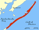
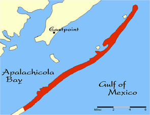
St. George Island
Encyclopedia
Gulf of Mexico
The Gulf of Mexico is a partially landlocked ocean basin largely surrounded by the North American continent and the island of Cuba. It is bounded on the northeast, north and northwest by the Gulf Coast of the United States, on the southwest and south by Mexico, and on the southeast by Cuba. In...
. It is a part of Franklin County
Franklin County, Florida
Franklin County is a coastal county located in the panhandle of the U.S. state of Florida. As of 2000, the population was 11,057. The U.S. Census Bureau 2005 estimate for the county is 11,177...
, Florida
Florida
Florida is a state in the southeastern United States, located on the nation's Atlantic and Gulf coasts. It is bordered to the west by the Gulf of Mexico, to the north by Alabama and Georgia and to the east by the Atlantic Ocean. With a population of 18,801,310 as measured by the 2010 census, it...
.
Physical characteristics
St. George is a barrier islandBarrier island
Barrier islands, a coastal landform and a type of barrier system, are relatively narrow strips of sand that parallel the mainland coast. They usually occur in chains, consisting of anything from a few islands to more than a dozen...
, 28 miles (45 km) long and 2 miles (3 km) wide at its widest point. St. George Island is adjacent to Cape St. George Island
Cape St. George Island
Cape St. George Island is an uninhabited barrier island situated on Florida’s North Gulf Coast, south-southeast of St. Vincent Island, west of St. George Island and 8-10 miles south-southwest of the town of Apalachicola in Franklin County, Florida. It was formerly part of St...
. The island is separated from the mainland by a four-mile (6 km) long bridge across Apalachicola Bay
Apalachicola Bay
Apalachicola Bay is an estuary and lagoon located on Florida's northwest coast renowned for its oysters. The Apalachicola Bay system also includes St. Georges Sound, St. Vincent Sound and East Bay, covering an area of about . Four islands St. Vincent Island to the west, Cape St. George Island and St...
, connecting to Eastpoint, Florida
Eastpoint, Florida
Eastpoint is a census-designated place in Franklin County, Florida, United States. The population was 2,158 at the 2000 census.-Geography:Eastpoint is located at ....
. Nearby towns include Eastpoint
Eastpoint, Florida
Eastpoint is a census-designated place in Franklin County, Florida, United States. The population was 2,158 at the 2000 census.-Geography:Eastpoint is located at ....
, Carrabelle
Carrabelle, Florida
Carrabelle is a city in Franklin County, Florida, United States. The population was 1,303 at the 2000 census. According to the U.S Census estimates of 2009, the city had a population of 1,231.-Location:...
and Apalachicola
Apalachicola, Florida
Apalachicola is a city in Franklin County, Florida, on US 98 about southwest of Tallahassee. The population was 2,334 at the 2000 census. The 2005 census estimated the city's population at 2,340...
. St. George Island is informally divided into three regions: Dr. Julian G. Bruce St. George Island State Park, a public strip of restaurants, bars, small businesses, homes and public beach, and a private and gated, highly exclusive housing community complete with its own airstrip. It is in this community that some of the most expensive multi-million dollar beach homes on the Gulf of Mexico are located.
The island is known for being quiet and tranquil due to its small size. Many occupants of the island rent out their homes during the spring and summer months. As of 2008, the island has no central sewage system and receives very little funding for road and infrastructure improvements, leading some to believe the island should form its own special taxing district. Saint George Island is said to be one of the most expensive islands on the Gulf to rent or own, and many purchase land on the island as an investment. A typical plot of land can range from $300,000 to $10,000,000.
St. George Island State Park
St. George Island State Park
St. George Island State Park is a Florida State Park located on the east end of St. George Island, approximately 10 miles southeast of Eastpoint, in northwestern Florida. Access to the park is off U.S. 98, by way of a 4-mile long bridge. The address is 1900 E...
occupies the eastern nine miles (14 km) of the island. People can camp there as well as swim with reservations. Many fishing reservations are also available in the area. The park has a series of hiking trails, boardwalks and observation platforms. Bird watching is a popular activity there. The area is well known for its excellent variety of Apalachicola Bay
Apalachicola Bay
Apalachicola Bay is an estuary and lagoon located on Florida's northwest coast renowned for its oysters. The Apalachicola Bay system also includes St. Georges Sound, St. Vincent Sound and East Bay, covering an area of about . Four islands St. Vincent Island to the west, Cape St. George Island and St...
and Gulf of Mexico
Gulf of Mexico
The Gulf of Mexico is a partially landlocked ocean basin largely surrounded by the North American continent and the island of Cuba. It is bounded on the northeast, north and northwest by the Gulf Coast of the United States, on the southwest and south by Mexico, and on the southeast by Cuba. In...
fish and seafood including oysters, scallops, grouper, flounder, redfish, snapper, trout, mullet and others.
History
St. George Island was first inhabited by the Creek Indians between the 10th and 15th centuries, who were all killed off by disease. With the arrival of EuropeanEuropean ethnic groups
The ethnic groups in Europe are the various ethnic groups that reside in the nations of Europe. European ethnology is the field of anthropology focusing on Europe....
colonists to the area in the late 18th century came an intense struggle for control. In 1803, the Creek Indians ceded a large tract of land, which included St. George Island, to trader John Forbes and Company, known as the Forbes Grant.
During the early and mid-20th century the island's pine forest was used for turpentine
Turpentine
Turpentine is a fluid obtained by the distillation of resin obtained from trees, mainly pine trees. It is composed of terpenes, mainly the monoterpenes alpha-pinene and beta-pinene...
production in naval stores
Naval stores
Naval Stores is a broad term which originally applied to the resin-based components used in building and maintaining wooden sailing ships, a category which includes cordage, mask, turpentine, rosin, pitch and tar...
.
During World War II
World War II
World War II, or the Second World War , was a global conflict lasting from 1939 to 1945, involving most of the world's nations—including all of the great powers—eventually forming two opposing military alliances: the Allies and the Axis...
, St. George Island was a practice range for B-24 bombers from nearby Apalachicola.
In 1954, the U.S. Army Corps of Engineers constructed the ship
Ship
Since the end of the age of sail a ship has been any large buoyant marine vessel. Ships are generally distinguished from boats based on size and cargo or passenger capacity. Ships are used on lakes, seas, and rivers for a variety of activities, such as the transport of people or goods, fishing,...
channel known as Bob Sikes Cut across St. George Island creating Cape St. George Island or "Little St. George Island" and enhanced its remoteness. The cut is used by the fishing fleet
Fishing fleet
A fishing fleet is an aggregate of commercial fishing vessels. The term may be used of all vessels operating out of a particular port, all vessels engaged in a particular type of fishing , or all fishing vessels of a country or region.Although fishing vessels are not formally organized as if they...
from Apalachicola and provides an access to the Gulf waters from the bayside.
St. George Island's early history began when in 1823 when John Lee Williams sought refuge there. With a shortage of food supplies, his crew depended on the island’s ample store of oysters and crabs. Soon afterwards, the island experienced a surge in trading activities especially along the banks of the Apalachicola River. This led to the construction of the central lighthouse on the island in 1833. It was used in those times as a navigational tool for incoming ships. However, it was destroyed in 2005 by a storm, much to the chagrin of native islanders. The lighthouse has since been reconstructed.
Geography
The island is composed of mostly sand dunes with sea oats and pine trees. The west end of the island is known as the St George Plantation. Its over 1200 acres (4.9 km²) with 24/7 security and accessible only to owners and their rental designees. It is quite a bit wider than the eastern portion of the island.Vegetation
Scrub and sea oatsSea oats
Uniola paniculata, or Sea oats, is a species of grass that grows along the East Coast and the Gulf Coast of the United States, Mexico, and on islands in the Caribbean.-Description:...
can be found on the newer dunes, Slash pine
Slash Pine
Pinus elliottii, commonly known as the Slash Pine, is a pine native to the southeastern United States, from southern South Carolina west to southeastern Louisiana, and south to the Florida Keys....
flatwoods in the older relic dunes. The western part of the island is more forested while the eastern two-thirds is more sparse in trees.