
Dalhart, Texas
Encyclopedia
Dalhart is a city in Dallam and Hartley counties in the U.S. state
of Texas
, and the county seat
of Dallam County. The population was 7,237 at the 2000 census. Founded in 1901, Dalhart is named for its location on the border of Dallam and Hartley counties. Dalhart sits at the intersection of U.S. Highway 87, 385, and 54. Two miles south of Dalhart is Rita Blanca Canyon, site of Rita Blanca Lake State Park.
The city of Dalhart is known by many Texans as a gateway to the Colorado
Rockies
. The city's position in the northwestern corner of the Texas Panhandle
-- only the town of Texline
is further northwestward in Texas—makes it a pivotal stopover for travelers going to or returning from the mountains. The City was founded at the site of a Railroad junction, which heavily contributed to its early growth.
Past and present notable residents: None
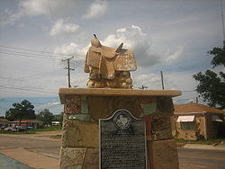 Dalhart is also known as the "XIT City" because of its relationship with the historic XIT Ranch
. The ranch was a 3000000 acres (12,140.6 km²) plot of land traded in exchange for the construction of the Texas State Capitol
in Austin
. The ranch was dissolved in 1912, but its history
is celebrated with the city's XIT Museum
and the XIT Rodeo and Reunion. Held annually on the first full Thursday through Sunday weekend of August, the event includes the world's largest free barbecue
, junior rodeo
as well as Professional Rodeo Cowboys Association
events, three nights of live music, and a variety of other offering to celebrate the occasion. The Empty Saddle Monument, located at the crossroads of Dalhart, was constructed in 1940 at the request of Bobby Dycke, the wife of a ranch hand, to recognize the contribution of the XIT cowboy
s to the history
of the region.
Dalhart was in the center of the Dust Bowl
, an area adversely affected by a long period of drought
and dust storms during the Great Depression
of the 1930s. It was here that Tex Thornton
operating on the now debunked concussion theory coaxed today's inflation adjusted equivalent of $1 million from the locals on claims he could fire rocket-powered explosives into the clouds and cause rain.
At the Dallam County Courthouse
, Dalhart honors the memory of James R. Fox, Jr. (March 16, 1919—March 11, 1943), who flew supplies to China
for Pan American Airways, then a joint Chinese and American company, during World War II
through the treacherous Hump Route
. Fox and his two Chinese copilots were killed, when their Douglas C-52 cargo plane crashed. In 2002, the Peoples Republic of China made a bronze bust
in Fox's honor and presented it to Dalhart.
According to the United States Census Bureau
, the city has a total area of 4.3 square miles (11.1 km²). None of the area is covered with water.
Dalhart is located closer to six other state capitals than to Texas' capital of Austin. In surface mileage (over major highways), Dalhart is 579 miles (931.8 km) from Austin http://maps.google.com/maps?f=q&hl=en&geocode=&q=from:+Dalhart,+TX+to:+Austin,+TX&sll=38.44085,-99.61514&sspn=7.104826,14.941406&ie=UTF8&ll=33.137551,-100.129395&spn=7.59481,14.941406&z=6&om=1, but is 263 miles (423.3 km) from Santa Fe, New Mexico
http://maps.google.com/maps?f=q&hl=en&geocode=&q=Dalhart,+TX+to+Santa+Fe,+NM&sll=37.0625,-95.677068&sspn=28.805654,59.765625&ie=UTF8&z=8&om=1, 343 miles (552 km) from Oklahoma City, Oklahoma
http://maps.google.com/maps?f=q&hl=en&geocode=&q=from:+Dalhart,+TX+to:+Oklahoma+City,+OK&sll=35.501365,-104.239575&sspn=1.846853,3.735352&ie=UTF8&z=7&om=1, 348 miles (560.1 km) from Denver, Colorado
http://maps.google.com/maps?f=q&hl=en&geocode=&q=from:+Dalhart,+TX+to:+Denver,+CO&sll=35.619295,-100.02144&sspn=3.687815,7.470703&ie=UTF8&z=6&om=1, 448 miles (721 km) from Cheyenne, Wyoming
http://maps.google.com/maps?f=q&hl=en&geocode=&q=from:+Dalhart,+TX+to:+Cheyenne,+WY&sll=37.8998,-103.76909&sspn=7.158782,14.941406&ie=UTF8&ll=38.5997,-103.776855&spn=7.089605,14.941406&z=6&om=1, 461 miles (741.9 km) from Topeka, Kansas
http://maps.google.com/maps?f=q&hl=en&geocode=&q=from:+Dalhart,+TX+to:+Topeka,+KS&sll=38.5997,-103.776855&sspn=7.089605,14.941406&ie=UTF8&z=7&om=1, and 540 miles (869 km) from Lincoln, Nebraska
http://maps.google.com/maps?f=q&hl=en&geocode=&q=from:+Dalhart,+TX+to:+Lincoln,+NE&sll=37.558025,-99.10002&sspn=3.596282,7.470703&ie=UTF8&z=6&om=1.
As the "crow flies," Dalhart is 491 miles (790.2 km) from Austin, but 201 miles (323.5 km) from Santa Fe, New Mexico
, 281 miles (452.2 km) from Oklahoma City
, 289 miles (465.1 km) from Denver, Colorado
, 375 miles (603.5 km) from Cheyenne, Wyoming
, 434 miles (698.5 km) from Topeka, Kansas
, and 458 miles (737.1 km) from Lincoln, Nebraska
.http://gc.kls2.com/cgi-bin/gc?PATH=dht-aus%2C+dht-saf%2C+dht-den%2C+dht-okc%2C+dht-top%2C+dht-lnk%2C+dht-cys%0D%0A&RANGE=&PATH-COLOR=navy&PATH-UNITS=mi&PATH-MINIMUM=&MARKER=1&SPEED-GROUND=&SPEED-UNITS=kts&RANGE-STYLE=best&RANGE-COLOR=navy&MAP-STYLE=
The city also has an impressively prodigious cattle feed lot in its outskirts, which contains thousands upon thousands of cows.
BSk) with cool, dry winters and hot, wetter summers.
of 2000, there were 7,237 people, 2,779 households, and 1,939 families residing in the city. The population density
was 1,686.1 people per square mile (651.3/km²). There were 3,101 housing units at an average density of 722.5 per square mile (279.1/km²). The racial makeup of the city was 85.44% White, 1.46% African American, 0.79% Native American, 0.32% Asian, 0.01% Pacific Islander, 9.96% from other races
, and 2.02% from two or more races. Hispanic or Latino of any race were 22.80% of the population.
There were 2,779 households out of which 36.2% had children under the age of 18 living with them, 55.7% were married couples
living together, 9.6% had a female householder with no husband present, and 30.2% were non-families. 26.8% of all households were made up of individuals and 12.3% had someone living alone who was 65 years of age or older. The average household size was 2.57 and the average family size was 3.12.
In the city the population was spread out with 29.7% under the age of 18, 7.7% from 18 to 24, 27.7% from 25 to 44, 21.7% from 45 to 64, and 13.2% who were 65 years of age or older. The median age was 34 years. For every 100 females there were 95.0 males. For every 100 females age 18 and over, there were 92.8 males.
The median income for a household in the city was $30,897, and the median income for a family was $39,193. Males had a median income of $29,521 versus $19,899 for females. The per capita income
for the city was $16,530. About 8.5% of families and 11.8% of the population were below the poverty line, including 13.0% of those under age 18 and 19.5% of those age 65 or over.
's Dalhart Unit
prison is located in unincorporated
Hartley County, near Dalhart.
, including farming, ranching, feedlot
operations, large scale pig
farms, and, more recently, relocated California
dairies
. The construction of a cheese
processing plant near the city by California based Hilmar Cheese Company will add an estimated three hundred jobs to the local economy and require additional dairies to meet the daily needs of the plant. The Hilmar plant itself is employing 120 people, of which about 30 were relocated from their original facility. Dalhart is also home to a state prison
.
During the heyday of the XIT Ranch, the land was in native grass. Some land was diverted into dry farmland, but there was insufficient rain to make it productive. Then a few irrigation wells were drilled in areas where the soil was not sandy and was level enough for row irrigation. Later center pivot irrigation
entered and was perfect for the rolling sandy soils. About the same time frame, big feedlots were built due to the low-humidity climate. This created a good market for corn
.
U.S. state
A U.S. state is any one of the 50 federated states of the United States of America that share sovereignty with the federal government. Because of this shared sovereignty, an American is a citizen both of the federal entity and of his or her state of domicile. Four states use the official title of...
of Texas
Texas
Texas is the second largest U.S. state by both area and population, and the largest state by area in the contiguous United States.The name, based on the Caddo word "Tejas" meaning "friends" or "allies", was applied by the Spanish to the Caddo themselves and to the region of their settlement in...
, and the county seat
County seat
A county seat is an administrative center, or seat of government, for a county or civil parish. The term is primarily used in the United States....
of Dallam County. The population was 7,237 at the 2000 census. Founded in 1901, Dalhart is named for its location on the border of Dallam and Hartley counties. Dalhart sits at the intersection of U.S. Highway 87, 385, and 54. Two miles south of Dalhart is Rita Blanca Canyon, site of Rita Blanca Lake State Park.
The city of Dalhart is known by many Texans as a gateway to the Colorado
Colorado
Colorado is a U.S. state that encompasses much of the Rocky Mountains as well as the northeastern portion of the Colorado Plateau and the western edge of the Great Plains...
Rockies
Rocky Mountains
The Rocky Mountains are a major mountain range in western North America. The Rocky Mountains stretch more than from the northernmost part of British Columbia, in western Canada, to New Mexico, in the southwestern United States...
. The city's position in the northwestern corner of the Texas Panhandle
Texas Panhandle
The Texas Panhandle is a region of the U.S. state of Texas consisting of the northernmost 26 counties in the state. The panhandle is a rectangular area bordered by New Mexico to the west and Oklahoma to the north and east...
-- only the town of Texline
Texline, Texas
Texline is a town in northwestern Dallam County, Texas, United States. The population was 511 at the 2000 census. The town is named for its location near the New Mexico-Texas state line. U.S. Highway 87 constitutes the main street of Texline....
is further northwestward in Texas—makes it a pivotal stopover for travelers going to or returning from the mountains. The City was founded at the site of a Railroad junction, which heavily contributed to its early growth.
Past and present notable residents: None
XIT Ranch
The XIT Ranch was a cattle ranch in the Texas Panhandle which operated from 1885 to 1912. Comprising over 3,000,000 acres of land, it ran for two hundred miles along the border with New Mexico, varying in width from 20 to 30 miles...
. The ranch was a 3000000 acres (12,140.6 km²) plot of land traded in exchange for the construction of the Texas State Capitol
Texas State Capitol
The Texas State Capitol is located in Austin, Texas, and is the fourth building to be the house of Texas government in Austin. It houses the chambers of the Texas Legislature and the office of the governor of Texas. It was designed originally during 1881 by architect Elijah E. Myers, and was...
in Austin
Austin, Texas
Austin is the capital city of the U.S. state of :Texas and the seat of Travis County. Located in Central Texas on the eastern edge of the American Southwest, it is the fourth-largest city in Texas and the 14th most populous city in the United States. It was the third-fastest-growing large city in...
. The ranch was dissolved in 1912, but its history
History
History is the discovery, collection, organization, and presentation of information about past events. History can also mean the period of time after writing was invented. Scholars who write about history are called historians...
is celebrated with the city's XIT Museum
XIT Museum
The XIT Museum in Dalhart, Texas, seeks to preserve the history and culture of one of the best-known ranches of the American West, the legendary XIT, which at its peak encompassed parts of ten Texas counties along a stretch of acreage in the late 19th century. The ranch operated from...
and the XIT Rodeo and Reunion. Held annually on the first full Thursday through Sunday weekend of August, the event includes the world's largest free barbecue
Barbecue
Barbecue or barbeque , used chiefly in the United States, Canada, the United Kingdom, New Zealand and Australia is a method and apparatus for cooking meat, poultry and occasionally fish with the heat and hot smoke of a fire, smoking wood, or hot coals of...
, junior rodeo
Rodeo
Rodeo is a competitive sport which arose out of the working practices of cattle herding in Spain, Mexico, and later the United States, Canada, South America and Australia. It was based on the skills required of the working vaqueros and later, cowboys, in what today is the western United States,...
as well as Professional Rodeo Cowboys Association
Professional Rodeo Cowboys Association
The Professional Rodeo Cowboys Association is an organization whose members compete in rodeos throughout North America, primarily in the United States. The PRCA sanctions rodeo venues and events through the PRCA Circuit System. Its championship event is the Wrangler National Finals Rodeo...
events, three nights of live music, and a variety of other offering to celebrate the occasion. The Empty Saddle Monument, located at the crossroads of Dalhart, was constructed in 1940 at the request of Bobby Dycke, the wife of a ranch hand, to recognize the contribution of the XIT cowboy
Cowboy
A cowboy is an animal herder who tends cattle on ranches in North America, traditionally on horseback, and often performs a multitude of other ranch-related tasks. The historic American cowboy of the late 19th century arose from the vaquero traditions of northern Mexico and became a figure of...
s to the history
History
History is the discovery, collection, organization, and presentation of information about past events. History can also mean the period of time after writing was invented. Scholars who write about history are called historians...
of the region.
Dalhart was in the center of the Dust Bowl
Dust Bowl
The Dust Bowl, or the Dirty Thirties, was a period of severe dust storms causing major ecological and agricultural damage to American and Canadian prairie lands from 1930 to 1936...
, an area adversely affected by a long period of drought
Drought
A drought is an extended period of months or years when a region notes a deficiency in its water supply. Generally, this occurs when a region receives consistently below average precipitation. It can have a substantial impact on the ecosystem and agriculture of the affected region...
and dust storms during the Great Depression
Great Depression
The Great Depression was a severe worldwide economic depression in the decade preceding World War II. The timing of the Great Depression varied across nations, but in most countries it started in about 1929 and lasted until the late 1930s or early 1940s...
of the 1930s. It was here that Tex Thornton
Tex Thornton
Charles Bates "Tex" Thornton was an American business executive who was the founder of Litton Industries.-Biography:...
operating on the now debunked concussion theory coaxed today's inflation adjusted equivalent of $1 million from the locals on claims he could fire rocket-powered explosives into the clouds and cause rain.
At the Dallam County Courthouse
Courthouse
A courthouse is a building that is home to a local court of law and often the regional county government as well, although this is not the case in some larger cities. The term is common in North America. In most other English speaking countries, buildings which house courts of law are simply...
, Dalhart honors the memory of James R. Fox, Jr. (March 16, 1919—March 11, 1943), who flew supplies to China
China
Chinese civilization may refer to:* China for more general discussion of the country.* Chinese culture* Greater China, the transnational community of ethnic Chinese.* History of China* Sinosphere, the area historically affected by Chinese culture...
for Pan American Airways, then a joint Chinese and American company, during World War II
World War II
World War II, or the Second World War , was a global conflict lasting from 1939 to 1945, involving most of the world's nations—including all of the great powers—eventually forming two opposing military alliances: the Allies and the Axis...
through the treacherous Hump Route
The Hump
The Hump was the name given by Allied pilots in the Second World War to the eastern end of the Himalayan Mountains over which they flew military transport aircraft from India to China to resupply the Chinese war effort of Chiang Kai-shek and the units of the United States Army Air Forces based in...
. Fox and his two Chinese copilots were killed, when their Douglas C-52 cargo plane crashed. In 2002, the Peoples Republic of China made a bronze bust
Bust (sculpture)
A bust is a sculpted or cast representation of the upper part of the human figure, depicting a person's head and neck, as well as a variable portion of the chest and shoulders. The piece is normally supported by a plinth. These forms recreate the likeness of an individual...
in Fox's honor and presented it to Dalhart.
Geography
Dalhart is located at 36°3′39"N 102°31′7"W (36.060856, -102.518656).According to the United States Census Bureau
United States Census Bureau
The United States Census Bureau is the government agency that is responsible for the United States Census. It also gathers other national demographic and economic data...
, the city has a total area of 4.3 square miles (11.1 km²). None of the area is covered with water.
Dalhart is located closer to six other state capitals than to Texas' capital of Austin. In surface mileage (over major highways), Dalhart is 579 miles (931.8 km) from Austin http://maps.google.com/maps?f=q&hl=en&geocode=&q=from:+Dalhart,+TX+to:+Austin,+TX&sll=38.44085,-99.61514&sspn=7.104826,14.941406&ie=UTF8&ll=33.137551,-100.129395&spn=7.59481,14.941406&z=6&om=1, but is 263 miles (423.3 km) from Santa Fe, New Mexico
Santa Fe, New Mexico
Santa Fe is the capital of the U.S. state of New Mexico. It is the fourth-largest city in the state and is the seat of . Santa Fe had a population of 67,947 in the 2010 census...
http://maps.google.com/maps?f=q&hl=en&geocode=&q=Dalhart,+TX+to+Santa+Fe,+NM&sll=37.0625,-95.677068&sspn=28.805654,59.765625&ie=UTF8&z=8&om=1, 343 miles (552 km) from Oklahoma City, Oklahoma
Oklahoma City, Oklahoma
Oklahoma City is the capital and the largest city in the state of Oklahoma. The county seat of Oklahoma County, the city ranks 31st among United States cities in population. The city's population, from the 2010 census, was 579,999, with a metro-area population of 1,252,987 . In 2010, the Oklahoma...
http://maps.google.com/maps?f=q&hl=en&geocode=&q=from:+Dalhart,+TX+to:+Oklahoma+City,+OK&sll=35.501365,-104.239575&sspn=1.846853,3.735352&ie=UTF8&z=7&om=1, 348 miles (560.1 km) from Denver, Colorado
Denver, Colorado
The City and County of Denver is the capital and the most populous city of the U.S. state of Colorado. Denver is a consolidated city-county, located in the South Platte River Valley on the western edge of the High Plains just east of the Front Range of the Rocky Mountains...
http://maps.google.com/maps?f=q&hl=en&geocode=&q=from:+Dalhart,+TX+to:+Denver,+CO&sll=35.619295,-100.02144&sspn=3.687815,7.470703&ie=UTF8&z=6&om=1, 448 miles (721 km) from Cheyenne, Wyoming
Cheyenne, Wyoming
Cheyenne is the capital and most populous city of the U.S. state of Wyoming and the county seat of Laramie County. It is the principal city of the Cheyenne, Wyoming, Metropolitan Statistical Area which encompasses all of Laramie County. The population is 59,466 at the 2010 census. Cheyenne is the...
http://maps.google.com/maps?f=q&hl=en&geocode=&q=from:+Dalhart,+TX+to:+Cheyenne,+WY&sll=37.8998,-103.76909&sspn=7.158782,14.941406&ie=UTF8&ll=38.5997,-103.776855&spn=7.089605,14.941406&z=6&om=1, 461 miles (741.9 km) from Topeka, Kansas
Topeka, Kansas
Topeka |Kansa]]: Tó Pee Kuh) is the capital city of the U.S. state of Kansas and the county seat of Shawnee County. It is situated along the Kansas River in the central part of Shawnee County, located in northeast Kansas, in the Central United States. As of the 2010 census, the city population was...
http://maps.google.com/maps?f=q&hl=en&geocode=&q=from:+Dalhart,+TX+to:+Topeka,+KS&sll=38.5997,-103.776855&sspn=7.089605,14.941406&ie=UTF8&z=7&om=1, and 540 miles (869 km) from Lincoln, Nebraska
Lincoln, Nebraska
The City of Lincoln is the capital and the second-most populous city of the US state of Nebraska. Lincoln is also the county seat of Lancaster County and the home of the University of Nebraska. Lincoln's 2010 Census population was 258,379....
http://maps.google.com/maps?f=q&hl=en&geocode=&q=from:+Dalhart,+TX+to:+Lincoln,+NE&sll=37.558025,-99.10002&sspn=3.596282,7.470703&ie=UTF8&z=6&om=1.
As the "crow flies," Dalhart is 491 miles (790.2 km) from Austin, but 201 miles (323.5 km) from Santa Fe, New Mexico
Santa Fe, New Mexico
Santa Fe is the capital of the U.S. state of New Mexico. It is the fourth-largest city in the state and is the seat of . Santa Fe had a population of 67,947 in the 2010 census...
, 281 miles (452.2 km) from Oklahoma City
Oklahoma city
Oklahoma City is the capital and largest city of the U.S. state of Oklahoma.Oklahoma City may also refer to:*Oklahoma City metropolitan area*Downtown Oklahoma City*Uptown Oklahoma City*Oklahoma City bombing*Oklahoma City National Memorial...
, 289 miles (465.1 km) from Denver, Colorado
Denver, Colorado
The City and County of Denver is the capital and the most populous city of the U.S. state of Colorado. Denver is a consolidated city-county, located in the South Platte River Valley on the western edge of the High Plains just east of the Front Range of the Rocky Mountains...
, 375 miles (603.5 km) from Cheyenne, Wyoming
Cheyenne, Wyoming
Cheyenne is the capital and most populous city of the U.S. state of Wyoming and the county seat of Laramie County. It is the principal city of the Cheyenne, Wyoming, Metropolitan Statistical Area which encompasses all of Laramie County. The population is 59,466 at the 2010 census. Cheyenne is the...
, 434 miles (698.5 km) from Topeka, Kansas
Topeka, Kansas
Topeka |Kansa]]: Tó Pee Kuh) is the capital city of the U.S. state of Kansas and the county seat of Shawnee County. It is situated along the Kansas River in the central part of Shawnee County, located in northeast Kansas, in the Central United States. As of the 2010 census, the city population was...
, and 458 miles (737.1 km) from Lincoln, Nebraska
Lincoln, Nebraska
The City of Lincoln is the capital and the second-most populous city of the US state of Nebraska. Lincoln is also the county seat of Lancaster County and the home of the University of Nebraska. Lincoln's 2010 Census population was 258,379....
.http://gc.kls2.com/cgi-bin/gc?PATH=dht-aus%2C+dht-saf%2C+dht-den%2C+dht-okc%2C+dht-top%2C+dht-lnk%2C+dht-cys%0D%0A&RANGE=&PATH-COLOR=navy&PATH-UNITS=mi&PATH-MINIMUM=&MARKER=1&SPEED-GROUND=&SPEED-UNITS=kts&RANGE-STYLE=best&RANGE-COLOR=navy&MAP-STYLE=
The city also has an impressively prodigious cattle feed lot in its outskirts, which contains thousands upon thousands of cows.
Climate
Dalhart experiences a semi-arid climate (KöppenKöppen climate classification
The Köppen climate classification is one of the most widely used climate classification systems. It was first published by Crimea German climatologist Wladimir Köppen in 1884, with several later modifications by Köppen himself, notably in 1918 and 1936...
BSk) with cool, dry winters and hot, wetter summers.
Demographics
As of the censusCensus
A census is the procedure of systematically acquiring and recording information about the members of a given population. It is a regularly occurring and official count of a particular population. The term is used mostly in connection with national population and housing censuses; other common...
of 2000, there were 7,237 people, 2,779 households, and 1,939 families residing in the city. The population density
Population density
Population density is a measurement of population per unit area or unit volume. It is frequently applied to living organisms, and particularly to humans...
was 1,686.1 people per square mile (651.3/km²). There were 3,101 housing units at an average density of 722.5 per square mile (279.1/km²). The racial makeup of the city was 85.44% White, 1.46% African American, 0.79% Native American, 0.32% Asian, 0.01% Pacific Islander, 9.96% from other races
Race (United States Census)
Race and ethnicity in the United States Census, as defined by the Federal Office of Management and Budget and the United States Census Bureau, are self-identification data items in which residents choose the race or races with which they most closely identify, and indicate whether or not they are...
, and 2.02% from two or more races. Hispanic or Latino of any race were 22.80% of the population.
There were 2,779 households out of which 36.2% had children under the age of 18 living with them, 55.7% were married couples
Marriage
Marriage is a social union or legal contract between people that creates kinship. It is an institution in which interpersonal relationships, usually intimate and sexual, are acknowledged in a variety of ways, depending on the culture or subculture in which it is found...
living together, 9.6% had a female householder with no husband present, and 30.2% were non-families. 26.8% of all households were made up of individuals and 12.3% had someone living alone who was 65 years of age or older. The average household size was 2.57 and the average family size was 3.12.
In the city the population was spread out with 29.7% under the age of 18, 7.7% from 18 to 24, 27.7% from 25 to 44, 21.7% from 45 to 64, and 13.2% who were 65 years of age or older. The median age was 34 years. For every 100 females there were 95.0 males. For every 100 females age 18 and over, there were 92.8 males.
The median income for a household in the city was $30,897, and the median income for a family was $39,193. Males had a median income of $29,521 versus $19,899 for females. The per capita income
Per capita income
Per capita income or income per person is a measure of mean income within an economic aggregate, such as a country or city. It is calculated by taking a measure of all sources of income in the aggregate and dividing it by the total population...
for the city was $16,530. About 8.5% of families and 11.8% of the population were below the poverty line, including 13.0% of those under age 18 and 19.5% of those age 65 or over.
Government and infrastructure
The Texas Department of Criminal JusticeTexas Department of Criminal Justice
The Texas Department of Criminal Justice is a department of the government of the state of Texas. The TDCJ is responsible for statewide criminal justice for adult offenders, including managing offenders in state prisons, state jails and private correctional facilities, funding and certain...
's Dalhart Unit
Dalhart Unit
The Dalhart Unit is a Texas Department of Criminal Justice prison for men located in unincorporated Hartley County, Texas. The unit is along Farm to Market Road 998 and near U.S. Highway 54, west and south of Dalhart. As of 2000 Dalhart serves minimum and medium security inmates.-History:The unit...
prison is located in unincorporated
Unincorporated area
In law, an unincorporated area is a region of land that is not a part of any municipality.To "incorporate" in this context means to form a municipal corporation, a city, town, or village with its own government. An unincorporated community is usually not subject to or taxed by a municipal government...
Hartley County, near Dalhart.
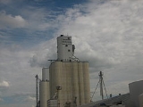
Economy
Dalhart's economy is centered around agribusinessAgribusiness
In agriculture, agribusiness is a generic term for the various businesses involved in food production, including farming and contract farming, seed supply, agrichemicals, farm machinery, wholesale and distribution, processing, marketing, and retail sales....
, including farming, ranching, feedlot
Feedlot
A feedlot or feedyard is a type of animal feeding operation which is used in factory farming for finishing livestock, notably beef cattle, but also swine, horses, sheep, turkeys, chickens or ducks, prior to slaughter. Large beef feedlots are called Concentrated Animal Feeding Operations . They...
operations, large scale pig
Pig
A pig is any of the animals in the genus Sus, within the Suidae family of even-toed ungulates. Pigs include the domestic pig, its ancestor the wild boar, and several other wild relatives...
farms, and, more recently, relocated California
California
California is a state located on the West Coast of the United States. It is by far the most populous U.S. state, and the third-largest by land area...
dairies
Dairy
A dairy is a business enterprise established for the harvesting of animal milk—mostly from cows or goats, but also from buffalo, sheep, horses or camels —for human consumption. A dairy is typically located on a dedicated dairy farm or section of a multi-purpose farm that is concerned...
. The construction of a cheese
Cheese
Cheese is a generic term for a diverse group of milk-based food products. Cheese is produced throughout the world in wide-ranging flavors, textures, and forms....
processing plant near the city by California based Hilmar Cheese Company will add an estimated three hundred jobs to the local economy and require additional dairies to meet the daily needs of the plant. The Hilmar plant itself is employing 120 people, of which about 30 were relocated from their original facility. Dalhart is also home to a state prison
Prison
A prison is a place in which people are physically confined and, usually, deprived of a range of personal freedoms. Imprisonment or incarceration is a legal penalty that may be imposed by the state for the commission of a crime...
.
During the heyday of the XIT Ranch, the land was in native grass. Some land was diverted into dry farmland, but there was insufficient rain to make it productive. Then a few irrigation wells were drilled in areas where the soil was not sandy and was level enough for row irrigation. Later center pivot irrigation
Center pivot irrigation
Center-pivot irrigation , also called circle irrigation, is a method of crop irrigation in which equipment rotates around a pivot...
entered and was perfect for the rolling sandy soils. About the same time frame, big feedlots were built due to the low-humidity climate. This created a good market for corn
Maize
Maize known in many English-speaking countries as corn or mielie/mealie, is a grain domesticated by indigenous peoples in Mesoamerica in prehistoric times. The leafy stalk produces ears which contain seeds called kernels. Though technically a grain, maize kernels are used in cooking as a vegetable...
.