
Folly Beach, South Carolina
Encyclopedia
Folly Beach is a city, located on historic Folly Island
, in Charleston County, South Carolina
, United States. The population was 2,117 at the 2000 census. As defined by the U.S. Office of Management and Budget, and used by the U.S. Census Bureau for statistical purposes only, Folly Beach is included within the Charleston-North Charleston-Summerville metropolitan area and the Charleston-North Charleston Urbanized Area.
According to the United States Census Bureau
, the city has a total area of 18.6 square miles (48.2 km²), of which, 12.3 square miles (31.9 km²) of it is land and 6.4 square miles (16.6 km²) of it (34.23%) is water.
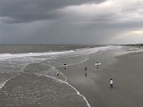
Known to Charleston locals as "the Edge of America", Folly Beach is home to numerous surf spots, the most popular being the Washout, 10th Street and the Folly Beach Pier. Despite its usually calm conditions, Folly Beach has gained prominence as one of the more popular surf spots along the East Coast. Folly Beach is an eclectic beach community with surf shops, restaurants, gift shops, offices, and bars along Center Street; the main road and gateway to the community.
, and 1.42% from two or more races. Hispanic or Latino of any race were 1.42% of the population.
There were 1,060 households out of which 13.0% had children under the age of 18 living with them, 38.0% were married couples living together, 4.9% had a female householder with no husband present, and 53.8% were non-families. 33.6% of all households were made up of individuals and 6.3% had someone living alone who was 65 years of age or older. The average household size was 2.00 and the average family size was 2.51.
In the city the age distribution of the population shows 10.9% under the age of 18, 13.6% from 18 to 24, 33.5% from 25 to 44, 29.6% from 45 to 64, and 12.4% who were 65 years of age or older. The median age was 41 years. For every 100 females there were 104.2 males. For every 100 females age 18 and over, there were 104.6 males.
The median income for a household in the city was $46,935, and the median income for a family was $66,058. Males had a median income of $34,125 versus $30,075 for females. The per capita income
for the city was $30,493. About 4.6% of families and 12.5% of the population were below the poverty line, including 8.7% of those under age 18 and 2.5% of those age 65 or over.
Beach parks:
Fishing piers:
Marinas and boat landings:
Day parks:
Water parks:
Off-leash dog parks are offered at James Island, Palmetto Islands, and North Charleston Wannamaker County Park.
James Island County Park, features a 50-foot climbing wall and bouldering cave; cabin, RV, and tent camping facilities; rental facilities, fishing dock, challenge course, kayaking programs, summer camps, paved trails, and many special events such as the Lowcountry Cajun Festival (usually the first weekend in April), East Coast Canoe and Kayak Festival (3rd weekend in April), Holiday Festival of Lights (mid-November through the first of the year), and the summer outdoor reggae concerts.
Folly Island
Folly Island is a barrier island in the Atlantic Ocean near Charleston, South Carolina. It is one of the Sea Islands and is within the boundaries of Charleston County, South Carolina. During the American Civil War, the island served as a major staging area for troops of the Union Army that were...
, in Charleston County, South Carolina
Charleston County, South Carolina
Charleston County is a county located in the U.S. state of South Carolina. According to a 2005 U.S. Census Bureau estimate, its population was 330,368. Its county seat is Charleston. It is the third-most populous county in the state . Charleston County was created in 1901 by an act of the South...
, United States. The population was 2,117 at the 2000 census. As defined by the U.S. Office of Management and Budget, and used by the U.S. Census Bureau for statistical purposes only, Folly Beach is included within the Charleston-North Charleston-Summerville metropolitan area and the Charleston-North Charleston Urbanized Area.
Geography
Folly Beach is located at 32°39′58"N 79°56′21"W (32.666152, -79.939213).According to the United States Census Bureau
United States Census Bureau
The United States Census Bureau is the government agency that is responsible for the United States Census. It also gathers other national demographic and economic data...
, the city has a total area of 18.6 square miles (48.2 km²), of which, 12.3 square miles (31.9 km²) of it is land and 6.4 square miles (16.6 km²) of it (34.23%) is water.
Known to Charleston locals as "the Edge of America", Folly Beach is home to numerous surf spots, the most popular being the Washout, 10th Street and the Folly Beach Pier. Despite its usually calm conditions, Folly Beach has gained prominence as one of the more popular surf spots along the East Coast. Folly Beach is an eclectic beach community with surf shops, restaurants, gift shops, offices, and bars along Center Street; the main road and gateway to the community.
Demographics
As of the census of 2000, there were 2,116 people, 1,060 households, and 489 families residing in the city. The population density was 172.7 people per square mile (66.6/km²). There were 1,747 housing units at an average density of 142.5 per square mile (55.0/km²). The racial makeup of the city was 96.64% White, 0.76% African American, 0.47% Native American, 0.19% Asian, 0.52% from other racesRace (United States Census)
Race and ethnicity in the United States Census, as defined by the Federal Office of Management and Budget and the United States Census Bureau, are self-identification data items in which residents choose the race or races with which they most closely identify, and indicate whether or not they are...
, and 1.42% from two or more races. Hispanic or Latino of any race were 1.42% of the population.
There were 1,060 households out of which 13.0% had children under the age of 18 living with them, 38.0% were married couples living together, 4.9% had a female householder with no husband present, and 53.8% were non-families. 33.6% of all households were made up of individuals and 6.3% had someone living alone who was 65 years of age or older. The average household size was 2.00 and the average family size was 2.51.
In the city the age distribution of the population shows 10.9% under the age of 18, 13.6% from 18 to 24, 33.5% from 25 to 44, 29.6% from 45 to 64, and 12.4% who were 65 years of age or older. The median age was 41 years. For every 100 females there were 104.2 males. For every 100 females age 18 and over, there were 104.6 males.
The median income for a household in the city was $46,935, and the median income for a family was $66,058. Males had a median income of $34,125 versus $30,075 for females. The per capita income
Per capita income
Per capita income or income per person is a measure of mean income within an economic aggregate, such as a country or city. It is calculated by taking a measure of all sources of income in the aggregate and dividing it by the total population...
for the city was $30,493. About 4.6% of families and 12.5% of the population were below the poverty line, including 8.7% of those under age 18 and 2.5% of those age 65 or over.
Council Members
Paul Hume, Pennell Clamp, Charlie McCarty, Laura Beck, Eddie Ellis, and D.J. RichCounty parks
The Charleston County Park and Recreation Commission (CCPRC) http://www.ccprc.com operates numerous facilities within Charleston County.Beach parks:
- Kiawah Beachwalker County Park, Kiawah Island, South CarolinaKiawah Island, South CarolinaKiawah is a sea island, or barrier island, on the Atlantic coast of the United States. Located south of Charleston in Charleston County, South Carolina, it is operated today largely as a beach and golf resort — the Kiawah Island Golf Resort — with spacious villas, beaches, large and acclaimed golf...
- Isle of Palms County Park, Isle of Palms, South CarolinaIsle of Palms, South CarolinaIsle of Palms is a city in Charleston County, South Carolina, United States. As of the 2010 census, the population on the island was 4,133. Isle of Palms is a barrier island on the South Carolina coast. As defined by the U.S. Office of Management and Budget, and used by the U.S...
- Folly Beach County Park, Folly Beach, South Carolina
Fishing piers:
- Folly Beach Fishing Pier, Folly Beach, South Carolina
- Mt. Pleasant Pier, Mt. Pleasant, South Carolina
Marinas and boat landings:
- Cooper River Marina
- Multiple county-wide boat landings
Day parks:
- Palmetto Islands County Park, Mt. Pleasant, South Carolina
- Caw Caw Nature and History Interpretive Center, Ravenel, South CarolinaRavenel, South CarolinaRavenel is a town in Charleston County and Dorchester County, South Carolina, United States. The population was 2,214 at the 2000 census. As defined by the U.S. Office of Management and Budget, and used by the U.S...
- North Charleston Wannamaker County Park, North Charleston, South CarolinaNorth Charleston, South CarolinaNorth Charleston is the 3rd largest city in the U.S. state of South Carolina with incorporated areas in Berkeley, Charleston, and Dorchester counties. On June 12, 1972 the city of North Charleston incorporated and was the 9th largest city in South Carolina. According to the 2010 Census, North...
- Mullet Hall Equestrian Center, Johns Island, South CarolinaJohns Island, South CarolinaJohns Island, also spelled John's Island, is the largest island in the U.S. State of South Carolina. It is one of the many Sea Islands along the coast of South Carolina.-Background:...
- James Island County Park, Charleston, South CarolinaCharleston, South CarolinaCharleston is the second largest city in the U.S. state of South Carolina. It was made the county seat of Charleston County in 1901 when Charleston County was founded. The city's original name was Charles Towne in 1670, and it moved to its present location from a location on the west bank of the...
Water parks:
- Splash Island at Palmetto Islands County Park
- Splash Zone at James Island County Park
- Whirlin' Waters at North Charleston Wannamaker County Park
Off-leash dog parks are offered at James Island, Palmetto Islands, and North Charleston Wannamaker County Park.
James Island County Park, features a 50-foot climbing wall and bouldering cave; cabin, RV, and tent camping facilities; rental facilities, fishing dock, challenge course, kayaking programs, summer camps, paved trails, and many special events such as the Lowcountry Cajun Festival (usually the first weekend in April), East Coast Canoe and Kayak Festival (3rd weekend in April), Holiday Festival of Lights (mid-November through the first of the year), and the summer outdoor reggae concerts.