
Ham Hill Country Park
Encyclopedia
Ham Hill is a geological Site of Special Scientific Interest (SSSI), Scheduled Ancient Monument
, Iron Age
hill fort
, Roman
site, Local Nature Reserve
and country park
, to the west of Yeovil
in Somerset
, England.
The hill has given its name to the distinctive quarried hamstone
, and also to two nearby villages: Stoke-sub-Hamdon
and Norton Sub Hamdon
, whose names mean under-Ham-hill (where Ham is Old English for a small settlement).
From Ham Hill the Mendip Hills
and Blackdown Hills
, Quantock Hills
and Dorset Downs
are all visible. It is popular for picnicking, walking, and mountain biking in the grassy hollows of the old quarry workings.
The geology supports a wide range of Fauna including mammals, birds, invertebrates, reptiles and amphibians living on lichens, fungi, ferns and flowering plants.
rock that is elevated above the lower lying clay
vale
s and nearby Somerset Levels
. The sedimentary rocks were laid down in the part of the early Jurassic
known as the Toarcian
Stage. They are given their colour by the weathering of the iron content of the stone and contain fossils such as the ammonite Dumortieria moorei.
The hamstone
is a distinctive honey-coloured building stone that has been used in local villages and for buildings such as Montacute House
and Sherborne Abbey
. Extensive old quarry
workings have changed the landscape into a warren of stoney ridges and grassy hollows. Quarrying has unearthed many important historical artefacts, but also destroyed much of the archaeological context.
The hill is an 11.1 ha
geological Site of Special Scientific Interest (SSSI), notified in 1971, because of its particular importance to geologists because of the assemblages of fossils which it contains, the sedimentary features which it displays and the way it relates to other rocks of equivalent age in the close vicinity.
, under Section 21 of the National Parks and Access to the Countryside Act 1949
, because of the rare calcareous grassland which supports a wide variety of plant and animal species and it's wild flower meadows and wide open grassland areas such as Witcombe Valley.
Fauna includes mammals, birds, invertebrates, reptiles and amphibians while the flora includes lichens, fungi, ferns and flowering plants.
 The name may come from the Old English ham and hyll giving a meaning of the settlement hill, however its original name was Hamdon, meaning the hill among the water meadows. There is evidence for occupation from the mesolithic
and neolithic
periods. Ham Hill is the site of a very large Bronze Age
and Iron Age
hill fort
of the Durotriges
tribe, from the 1st century BC. The 3 miles (5 km) ramparts enclose an area of 210 acres (85 ha). Most of the perimeter is a double bank and ditch (multivallate). There is a major entrance to the south-east, on the line of the modern road, and another to the north-east, following a track from the Church of St Mary the Virgin
at East Stoke in Stoke-sub-Hamdon
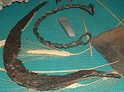
. Archaeological finds include bronze-work, chariot parts, iron currency bars, gold and silver coins, cremations and burials.
The hill was captured around AD
45 by the Roman
Second Legion (Augusta)
, led by the future emperor Vespasian
, who had already captured Maiden Castle
and other hill forts to the south. Many Roman military artefacts have been found, and it is quite likely that the Second Legion made a temporary camp on the hill, as at Hod Hill
. After the initial campaigns, a more permanent Roman camp was established at nearby Ilchester
, and the Fosse Way
military road was constructed within 1 miles (2 km) of Ham Hill, on its way to Axminster
and the garrison at Exeter
. The area was very prosperous in the Roman period, and several major villas have been found nearby, including one on the eastern part of the hill in the field known as "Warren", with extensive mosaic. Other villas have been found at Stoke-sub-Hamdon
, Odcombe
, Lufton, and West Coker
. Just to the east of the main plateau is the isolated St. Michael's Hill, the pointed hill that gives its name to the village of Montacute
, and which was turned into a motte-and-bailey
castle by the Normans
.
 South of the main hill are strip lynchets, or low terraces created by ancient ploughing and cultivation, and the deserted medieval village
of Witcombe (or Whitcombe), which was finally abandoned in the 17th century.
In the 1800s there were 24 small quarries operating on the hill employing some 200 men. This continued into the Victorian era
with over of 200 small family run quarries and masonry businesses. Many of these small quarries ceased working by 1910. Today Hamstone is only quarried in two areas on the top of Ham Hill. The North quarry, near the modern stone circle and war memorial, is the longest running Hamstone quarry in existence. The southern, Norton Quarry extracts its stone from some 20–30 metres below the surface and is quarried by Harvey Stone. This quarry was reopened around 15 years ago, having been the last quarry abandoned in the 1930s due to there being, according to the masons working the hill "no good quality stone left". Both quarries are owned by the Duchy of Cornwall
.
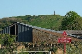
The northern end of the plateau is crowned by a war memorial
to the dead of the nearby village of Stoke-sub-Hamdon
killed during the two World Wars. It was designed in 1920 and unveiled in 1923 with four steps which lead to a square plinth and a tapering four-sided obelisk with a flat top. The memorial is clearly visible from the surrounding countryside, including the A303 trunk road which now follows the course of the Fosse Way
near the base of the hill. Just below the Monument is a bench dedicated to the memory of local student Alan Kneebone, murdered while at Wakefield College
in 2001.
. It is the end of the Leland trail
a 28 miles (45.1 km) footpath which runs from King Alfred's Tower
to Ham Hill Country Park.
There is a limited amount of climbing available at Ham Hill with roughly 20 routes. These are top roped routes due to the nature of the rock, the difficulty of "topping out" and because the rock is or geological interest. There are also several bouldering
problems.
There are two compass trails for orienteering: one in the stone circle area, and one in Witcombe Valley. There are marked by sets of letters printed on small squares from A - J, which are attached to fence posts, signposts, gate and boulders.
Ham Hill is also close to the Monarch's Way
a 615 miles (990 km) long-distance footpath
that approximates the escape
route taken by King Charles II
in 1651 after being defeated in the Battle of Worcester
. and the start of the Liberty Trail
which covers 28 miles (45.1 km) to Lyme Regis
in Dorset
.
by South Somerset
Council and is visited by over 250,000 people each year.
Prior to the designation of Ham Hill as a country park, three local farms used ancient free range grazing rights on the main grass area of the hill. Country Park status brought more visitors, and most importantly more dogs. The dogs made the grazing of sheep impossible. This has resulted in a noticeable change in vegetation in the last forty years. In many areas, what were areas of short-cropped grassland interspersed with short stemmed plants as wild thyme and clovers have been replaced by rank bracken, gorse, bramble and wild parsley. The absence of the sheep has also enabled woodland to overrun and obscure the previously grassed Iron Age earthworks, most noticeably on the northern flank of the hill. A disastrous fire on the south-west flank of the hill (overlooking Little Norton) in the drought summer of 1975 was believed to have been caused by a discarded cigarette. The vegetation on the entire side of the hill was destroyed. When regrowth appeared, Bracken was the dominant vegetation. In some places this has now given way to woodland, but the fine grassland of before the fire has not returned.
Other changes are due to farming habits. In years past the plateau fields were almost exclusively used for grazing or growing spring wheat, and left fallow during the winter. In some years the fields were lightly ploughed and Mangolds grown for winter fodder. Following a change in ownership during the 1980s this altered to winter-sown grain with deep ploughing with sludge injection. The change caused an immediate change to the wildlife. The winter flocks of finches were lost, the yellowhammers disappeared, the skylarks nearly so. The deep ploughing proved counter productive as millions of poppy seeds were brought to the surface making the grain difficult to harvest - something that had been warned of years earlier by a previous farmer but disregarded. It was around this time that deep ploughing probably damaged the remains of the Roman Mozaic at Batemore: the site was ploughed over (it had never been marked on the ground) and small pieces of tile were brought to the surface. The plateau fields are now under the control of the park authorities, who are attempting to restore them by allowing natural grassland regrowth, with controlled sheep grazing.
Scheduled Ancient Monument
In the United Kingdom, a scheduled monument is a 'nationally important' archaeological site or historic building, given protection against unauthorized change. The various pieces of legislation used for legally protecting heritage assets from damage and destruction are grouped under the term...
, Iron Age
Iron Age
The Iron Age is the archaeological period generally occurring after the Bronze Age, marked by the prevalent use of iron. The early period of the age is characterized by the widespread use of iron or steel. The adoption of such material coincided with other changes in society, including differing...
hill fort
Hill fort
A hill fort is a type of earthworks used as a fortified refuge or defended settlement, located to exploit a rise in elevation for defensive advantage. They are typically European and of the Bronze and Iron Ages. Some were used in the post-Roman period...
, Roman
Roman Empire
The Roman Empire was the post-Republican period of the ancient Roman civilization, characterised by an autocratic form of government and large territorial holdings in Europe and around the Mediterranean....
site, Local Nature Reserve
Local Nature Reserve
Local nature reserve or LNR is a designation for nature reserves in the United Kingdom. The designation has its origin in the recommendations of the Wild Life Conservation Special Committee which established the framework for nature conservation in the United Kingdom and suggested a national suite...
and country park
Country park
A country park is an area designated for people to visit and enjoy recreation in a countryside environment.-History:In the United Kingdom the term 'Country Park' has a special meaning. There are over 400 Country Parks in England alone . Most Country Parks were designated in the 1970s, under the...
, to the west of Yeovil
Yeovil
Yeovil is a town and civil parish in south Somerset, England. The parish had a population of 27,949 at the 2001 census, although the wider urban area had a population of 42,140...
in Somerset
Somerset
The ceremonial and non-metropolitan county of Somerset in South West England borders Bristol and Gloucestershire to the north, Wiltshire to the east, Dorset to the south-east, and Devon to the south-west. It is partly bounded to the north and west by the Bristol Channel and the estuary of the...
, England.
The hill has given its name to the distinctive quarried hamstone
Hamstone
Hamstone is the colloquial name given to stone from Ham Hill, Somerset, England. Hamstone is a Jurassic limestone from the Toarcian, or Upper Lias, stage. It is a well cemented medium to coarse grained limestone characterised by its honey-gold colour and marked bedding planes. The stone contains...
, and also to two nearby villages: Stoke-sub-Hamdon
Stoke-sub-Hamdon
Stoke-sub-Hamdon is a village and civil parish in South Somerset, situated west of Yeovil, England. The parish is located near the River Parrett, and includes the village of East Stoke.-History:...
and Norton Sub Hamdon
Norton Sub Hamdon
Norton sub Hamdon is a village in the South Somerset district of the English county of Somerset, situated five miles west of Yeovil. The village has a population of 694....
, whose names mean under-Ham-hill (where Ham is Old English for a small settlement).
From Ham Hill the Mendip Hills
Mendip Hills
The Mendip Hills is a range of limestone hills to the south of Bristol and Bath in Somerset, England. Running east to west between Weston-super-Mare and Frome, the hills overlook the Somerset Levels to the south and the Avon Valley to the north...
and Blackdown Hills
Blackdown Hills
The Blackdown Hills are a range of hills along the Somerset-Devon border in south-western England, which were designated an Area of Outstanding Natural Beauty in 1991....
, Quantock Hills
Quantock Hills
The Quantock Hills is a range of hills west of Bridgwater in Somerset, England. The Quantock Hills were England’s first Area of Outstanding Natural Beauty being designated in 1956 and consists of large amounts of heathland, oak woodlands, ancient parklands and agricultural land.The hills run from...
and Dorset Downs
Dorset Downs
The Dorset Downs are an area of Chalk downland in the centre of the county Dorset in south west England. The downs are the most western part of a larger Chalk Formation which also includes Cranborne Chase, Salisbury Plain, Hampshire Downs, Chiltern Hills, North Downs and South Downs.The Dorset...
are all visible. It is popular for picnicking, walking, and mountain biking in the grassy hollows of the old quarry workings.
The geology supports a wide range of Fauna including mammals, birds, invertebrates, reptiles and amphibians living on lichens, fungi, ferns and flowering plants.
Geology
The hill is part of ridge of sandy limestoneLimestone
Limestone is a sedimentary rock composed largely of the minerals calcite and aragonite, which are different crystal forms of calcium carbonate . Many limestones are composed from skeletal fragments of marine organisms such as coral or foraminifera....
rock that is elevated above the lower lying clay
Clay
Clay is a general term including many combinations of one or more clay minerals with traces of metal oxides and organic matter. Geologic clay deposits are mostly composed of phyllosilicate minerals containing variable amounts of water trapped in the mineral structure.- Formation :Clay minerals...
vale
River Valley
River Valley is the name of an urban planning area within the Central Area, Singapore's central business district.The River Valley Planning Area is defined by the region bounded by Orchard Boulevard, Devonshire Road and Eber Road to the north, Oxley Rise and Mohamed Sultan Road to the east, Martin...
s and nearby Somerset Levels
Somerset Levels
The Somerset Levels, or the Somerset Levels and Moors as they are less commonly but more correctly known, is a sparsely populated coastal plain and wetland area of central Somerset, South West England, between the Quantock and Mendip Hills...
. The sedimentary rocks were laid down in the part of the early Jurassic
Jurassic
The Jurassic is a geologic period and system that extends from about Mya to Mya, that is, from the end of the Triassic to the beginning of the Cretaceous. The Jurassic constitutes the middle period of the Mesozoic era, also known as the age of reptiles. The start of the period is marked by...
known as the Toarcian
Toarcian
The Toarcian is, in the ICS' geologic timescale, an age or stage in the Early or Lower Jurassic. It spans the time between 183.0 Ma and 175.6 Ma...
Stage. They are given their colour by the weathering of the iron content of the stone and contain fossils such as the ammonite Dumortieria moorei.
The hamstone
Hamstone
Hamstone is the colloquial name given to stone from Ham Hill, Somerset, England. Hamstone is a Jurassic limestone from the Toarcian, or Upper Lias, stage. It is a well cemented medium to coarse grained limestone characterised by its honey-gold colour and marked bedding planes. The stone contains...
is a distinctive honey-coloured building stone that has been used in local villages and for buildings such as Montacute House
Montacute House
Montacute House is a late Elizabethan country house situated in the South Somerset village of Montacute. This house is a textbook example of English architecture during a period that was moving from the medieval Gothic to the Renaissance Classical; this has resulted in Montacute being regarded as...
and Sherborne Abbey
Sherborne Abbey
The Abbey Church of St Mary the Virgin at Sherborne in the English county of Dorset, is usually called Sherborne Abbey. It has been a Saxon cathedral , a Benedictine abbey and is now a parish church.- Cathedral :...
. Extensive old quarry
Quarry
A quarry is a type of open-pit mine from which rock or minerals are extracted. Quarries are generally used for extracting building materials, such as dimension stone, construction aggregate, riprap, sand, and gravel. They are often collocated with concrete and asphalt plants due to the requirement...
workings have changed the landscape into a warren of stoney ridges and grassy hollows. Quarrying has unearthed many important historical artefacts, but also destroyed much of the archaeological context.
The hill is an 11.1 ha
Hectare
The hectare is a metric unit of area defined as 10,000 square metres , and primarily used in the measurement of land. In 1795, when the metric system was introduced, the are was defined as being 100 square metres and the hectare was thus 100 ares or 1/100 km2...
geological Site of Special Scientific Interest (SSSI), notified in 1971, because of its particular importance to geologists because of the assemblages of fossils which it contains, the sedimentary features which it displays and the way it relates to other rocks of equivalent age in the close vicinity.
Ecology
Ham Hill is managed as a Local Nature ReserveLocal Nature Reserve
Local nature reserve or LNR is a designation for nature reserves in the United Kingdom. The designation has its origin in the recommendations of the Wild Life Conservation Special Committee which established the framework for nature conservation in the United Kingdom and suggested a national suite...
, under Section 21 of the National Parks and Access to the Countryside Act 1949
National Parks and Access to the Countryside Act 1949
The National Parks and Access to the Countryside Act 1949 is an Act of the Parliament of the United Kingdom which created the National Parks Commission which later became the Countryside Commission and then the Countryside Agency, which became Natural England when it merged with English Nature in...
, because of the rare calcareous grassland which supports a wide variety of plant and animal species and it's wild flower meadows and wide open grassland areas such as Witcombe Valley.
Fauna includes mammals, birds, invertebrates, reptiles and amphibians while the flora includes lichens, fungi, ferns and flowering plants.
History
Mesolithic
The Mesolithic is an archaeological concept used to refer to certain groups of archaeological cultures defined as falling between the Paleolithic and the Neolithic....
and neolithic
Neolithic
The Neolithic Age, Era, or Period, or New Stone Age, was a period in the development of human technology, beginning about 9500 BC in some parts of the Middle East, and later in other parts of the world. It is traditionally considered as the last part of the Stone Age...
periods. Ham Hill is the site of a very large Bronze Age
Bronze Age
The Bronze Age is a period characterized by the use of copper and its alloy bronze as the chief hard materials in the manufacture of some implements and weapons. Chronologically, it stands between the Stone Age and Iron Age...
and Iron Age
Iron Age
The Iron Age is the archaeological period generally occurring after the Bronze Age, marked by the prevalent use of iron. The early period of the age is characterized by the widespread use of iron or steel. The adoption of such material coincided with other changes in society, including differing...
hill fort
Hill fort
A hill fort is a type of earthworks used as a fortified refuge or defended settlement, located to exploit a rise in elevation for defensive advantage. They are typically European and of the Bronze and Iron Ages. Some were used in the post-Roman period...
of the Durotriges
Durotriges
The Durotriges were one of the Celtic tribes living in Britain prior to the Roman invasion. The tribe lived in modern Dorset, south Wiltshire and south Somerset...
tribe, from the 1st century BC. The 3 miles (5 km) ramparts enclose an area of 210 acres (85 ha). Most of the perimeter is a double bank and ditch (multivallate). There is a major entrance to the south-east, on the line of the modern road, and another to the north-east, following a track from the Church of St Mary the Virgin
Church of St Mary the Virgin, East Stoke
The Church of St Mary the Virgin at East Stoke in Stoke-sub-Hamdon, Somerset, England dates from the 12th century. It has been designated as a Grade I listed building....
at East Stoke in Stoke-sub-Hamdon
Stoke-sub-Hamdon
Stoke-sub-Hamdon is a village and civil parish in South Somerset, situated west of Yeovil, England. The parish is located near the River Parrett, and includes the village of East Stoke.-History:...
. Archaeological finds include bronze-work, chariot parts, iron currency bars, gold and silver coins, cremations and burials.
The hill was captured around AD
Anno Domini
and Before Christ are designations used to label or number years used with the Julian and Gregorian calendars....
45 by the Roman
Roman Empire
The Roman Empire was the post-Republican period of the ancient Roman civilization, characterised by an autocratic form of government and large territorial holdings in Europe and around the Mediterranean....
Second Legion (Augusta)
Legio II Augusta
Legio secunda Augusta , was a Roman legion, levied by Gaius Vibius Pansa Caetronianus in 43 BC, and still operative in Britannia in the 4th century...
, led by the future emperor Vespasian
Vespasian
Vespasian , was Roman Emperor from 69 AD to 79 AD. Vespasian was the founder of the Flavian dynasty, which ruled the Empire for a quarter century. Vespasian was descended from a family of equestrians, who rose into the senatorial rank under the Emperors of the Julio-Claudian dynasty...
, who had already captured Maiden Castle
Maiden Castle, Dorset
Maiden Castle is an Iron Age hill fort south west of Dorchester, in the English county of Dorset. Hill forts were fortified hill-top settlements constructed across Britain during the Iron Age...
and other hill forts to the south. Many Roman military artefacts have been found, and it is quite likely that the Second Legion made a temporary camp on the hill, as at Hod Hill
Hod Hill
Hod Hill is a large hill fort in the Blackmore Vale, north-west of Blandford Forum, Dorset, England. The fort sits on a chalk hill that is detached from the Dorset Downs and Cranborne Chase. The hill fort at Hambledon Hill is just to the north.The fort is roughly rectangular , with an enclosed...
. After the initial campaigns, a more permanent Roman camp was established at nearby Ilchester
Ilchester
Ilchester is a village and civil parish, situated on the River Yeo or Ivel, five miles north of Yeovil, in the English county of Somerset. The parish, which includes the village of Sock Dennis and the old parish of Northover, has a population of 2,021...
, and the Fosse Way
Fosse Way
The Fosse Way was a Roman road in England that linked Exeter in South West England to Lincoln in Lincolnshire, via Ilchester , Bath , Cirencester and Leicester .It joined Akeman Street and Ermin Way at Cirencester, crossed Watling Street at Venonis south...
military road was constructed within 1 miles (2 km) of Ham Hill, on its way to Axminster
Woodbury Farm Roman Fort
Moridunum was a fort and small town in the Roman province of Britannia. Its remains are located at Woodbury Farm, immediately south of Axminster in the English county of Devon....
and the garrison at Exeter
Exeter
Exeter is a historic city in Devon, England. It lies within the ceremonial county of Devon, of which it is the county town as well as the home of Devon County Council. Currently the administrative area has the status of a non-metropolitan district, and is therefore under the administration of the...
. The area was very prosperous in the Roman period, and several major villas have been found nearby, including one on the eastern part of the hill in the field known as "Warren", with extensive mosaic. Other villas have been found at Stoke-sub-Hamdon
Stoke-sub-Hamdon
Stoke-sub-Hamdon is a village and civil parish in South Somerset, situated west of Yeovil, England. The parish is located near the River Parrett, and includes the village of East Stoke.-History:...
, Odcombe
Odcombe
Odcombe is a village and civil parish in south Somerset, England, west of the town of Yeovil, with a population of 730 in 2002.The upper part of the village, Higher Odcombe, sits on the crest of the hill, while the lower part, Lower Odcombe, is built on its northern slopes...
, Lufton, and West Coker
West Coker
West Coker is a village and civil parish in Somerset, England, situated south west of Yeovil in the South Somerset district.-History:The name Coker comes from Coker Water ....
. Just to the east of the main plateau is the isolated St. Michael's Hill, the pointed hill that gives its name to the village of Montacute
Montacute
Montacute is a small village and civil parish in Somerset, England, west of Yeovil. The village has a population of 680 . The name Montacute is thought by some to derive from the Latin "Mons Acutus", referring to the small but still quite acute hill dominating the village to the west.The village...
, and which was turned into a motte-and-bailey
Motte-and-bailey
A motte-and-bailey is a form of castle, with a wooden or stone keep situated on a raised earthwork called a motte, accompanied by an enclosed courtyard, or bailey, surrounded by a protective ditch and palisade...
castle by the Normans
Normans
The Normans were the people who gave their name to Normandy, a region in northern France. They were descended from Norse Viking conquerors of the territory and the native population of Frankish and Gallo-Roman stock...
.
Deserted medieval village
In the United Kingdom, a deserted medieval village is a former settlement which was abandoned during the Middle Ages, typically leaving no trace apart from earthworks or cropmarks. If there are fewer than three inhabited houses the convention is to regard the site as deserted; if there are more...
of Witcombe (or Whitcombe), which was finally abandoned in the 17th century.
In the 1800s there were 24 small quarries operating on the hill employing some 200 men. This continued into the Victorian era
Victorian era
The Victorian era of British history was the period of Queen Victoria's reign from 20 June 1837 until her death on 22 January 1901. It was a long period of peace, prosperity, refined sensibilities and national self-confidence...
with over of 200 small family run quarries and masonry businesses. Many of these small quarries ceased working by 1910. Today Hamstone is only quarried in two areas on the top of Ham Hill. The North quarry, near the modern stone circle and war memorial, is the longest running Hamstone quarry in existence. The southern, Norton Quarry extracts its stone from some 20–30 metres below the surface and is quarried by Harvey Stone. This quarry was reopened around 15 years ago, having been the last quarry abandoned in the 1930s due to there being, according to the masons working the hill "no good quality stone left". Both quarries are owned by the Duchy of Cornwall
Duchy of Cornwall
The Duchy of Cornwall is one of two royal duchies in England, the other being the Duchy of Lancaster. The eldest son of the reigning British monarch inherits the duchy and title of Duke of Cornwall at the time of his birth, or of his parent's succession to the throne. If the monarch has no son, the...
.
The northern end of the plateau is crowned by a war memorial
War memorial
A war memorial is a building, monument, statue or other edifice to celebrate a war or victory, or to commemorate those who died or were injured in war.-Historic usage:...
to the dead of the nearby village of Stoke-sub-Hamdon
Stoke-sub-Hamdon
Stoke-sub-Hamdon is a village and civil parish in South Somerset, situated west of Yeovil, England. The parish is located near the River Parrett, and includes the village of East Stoke.-History:...
killed during the two World Wars. It was designed in 1920 and unveiled in 1923 with four steps which lead to a square plinth and a tapering four-sided obelisk with a flat top. The memorial is clearly visible from the surrounding countryside, including the A303 trunk road which now follows the course of the Fosse Way
Fosse Way
The Fosse Way was a Roman road in England that linked Exeter in South West England to Lincoln in Lincolnshire, via Ilchester , Bath , Cirencester and Leicester .It joined Akeman Street and Ermin Way at Cirencester, crossed Watling Street at Venonis south...
near the base of the hill. Just below the Monument is a bench dedicated to the memory of local student Alan Kneebone, murdered while at Wakefield College
Wakefield College
Wakefield College is a Further Education College in Wakefield, West Yorkshire, England. It has provided education within the city since 1868 .-History:...
in 2001.
Recreation
The hill and the country park around it provide a venue for a variety of leisure and recreational uses, including walking, horse riding, mountain biking and orienteeringOrienteering
Orienteering is a family of sports that requires navigational skills using a map and compass to navigate from point to point in diverse and usually unfamiliar terrain, and normally moving at speed. Participants are given a topographical map, usually a specially prepared orienteering map, which they...
. It is the end of the Leland trail
Leland trail
The Leland Trail, a footpath in Somerset, England. It runs from King Alfred's Tower in Penselwood to Ham Hill Country Park.-History:The path was established by creating rights of way via tracks and lanes. It is named after John Leland who visited South Somerset during the years 1535 - 1543...
a 28 miles (45.1 km) footpath which runs from King Alfred's Tower
King Alfred's Tower
King Alfred's Tower or The Folly of King Alfred the Great is in the parish of Brewham, Somerset, and was built as part of the celebrated Stourhead estate and landscape. The tower stands on Kingsettle Hill and nowadays belongs to the National Trust...
to Ham Hill Country Park.
There is a limited amount of climbing available at Ham Hill with roughly 20 routes. These are top roped routes due to the nature of the rock, the difficulty of "topping out" and because the rock is or geological interest. There are also several bouldering
Bouldering
Bouldering is a style of rock climbing undertaken without a rope and normally limited to very short climbs over a crash pad so that a fall will not result in serious injury. It is typically practiced on large natural boulders or artificial boulders in gyms and outdoor urban areas...
problems.
There are two compass trails for orienteering: one in the stone circle area, and one in Witcombe Valley. There are marked by sets of letters printed on small squares from A - J, which are attached to fence posts, signposts, gate and boulders.
Ham Hill is also close to the Monarch's Way
Monarch's Way
The Monarch's Way is a long-distance footpath in England that approximates the escape route taken by King Charles II in 1651 after being defeated in the Battle of Worcester.Most of the footpath is waymarked...
a 615 miles (990 km) long-distance footpath
Trail
A trail is a path with a rough beaten or dirt/stone surface used for travel. Trails may be for use only by walkers and in some places are the main access route to remote settlements...
that approximates the escape
Escape of Charles II
The Escape of Charles II from England in 1651 is a key episode in his life. Although it took only six weeks, it had a major effect on his attitudes for the rest of his life.-The fugitive king:...
route taken by King Charles II
Charles II of England
Charles II was monarch of the three kingdoms of England, Scotland, and Ireland.Charles II's father, King Charles I, was executed at Whitehall on 30 January 1649, at the climax of the English Civil War...
in 1651 after being defeated in the Battle of Worcester
Battle of Worcester
The Battle of Worcester took place on 3 September 1651 at Worcester, England and was the final battle of the English Civil War. Oliver Cromwell and the Parliamentarians defeated the Royalist, predominantly Scottish, forces of King Charles II...
. and the start of the Liberty Trail
Liberty Trail
A 28-mile trail between Ham Hill in Somerset and Lyme Regis in Dorset, England.-History:The route of the Liberty Trail route is based on information recorded by six rebels from various villages in Somerset and Dorset. Villagers from the two counties made their way to join the Protestant Monmouth...
which covers 28 miles (45.1 km) to Lyme Regis
Lyme Regis
Lyme Regis is a coastal town in West Dorset, England, situated 25 miles west of Dorchester and east of Exeter. The town lies in Lyme Bay, on the English Channel coast at the Dorset-Devon border...
in Dorset
Dorset
Dorset , is a county in South West England on the English Channel coast. The county town is Dorchester which is situated in the south. The Hampshire towns of Bournemouth and Christchurch joined the county with the reorganisation of local government in 1974...
.
Country Park
Ham Hill is operated as a 390 acres (157.8 ha) country parkCountry park
A country park is an area designated for people to visit and enjoy recreation in a countryside environment.-History:In the United Kingdom the term 'Country Park' has a special meaning. There are over 400 Country Parks in England alone . Most Country Parks were designated in the 1970s, under the...
by South Somerset
South Somerset
South Somerset is a local government district in Somerset, England.The South Somerset district covers and area of ranging from the borders with Devon and Dorset to the edge of the Somerset Levels. It has a population of approximately 158,000...
Council and is visited by over 250,000 people each year.
Prior to the designation of Ham Hill as a country park, three local farms used ancient free range grazing rights on the main grass area of the hill. Country Park status brought more visitors, and most importantly more dogs. The dogs made the grazing of sheep impossible. This has resulted in a noticeable change in vegetation in the last forty years. In many areas, what were areas of short-cropped grassland interspersed with short stemmed plants as wild thyme and clovers have been replaced by rank bracken, gorse, bramble and wild parsley. The absence of the sheep has also enabled woodland to overrun and obscure the previously grassed Iron Age earthworks, most noticeably on the northern flank of the hill. A disastrous fire on the south-west flank of the hill (overlooking Little Norton) in the drought summer of 1975 was believed to have been caused by a discarded cigarette. The vegetation on the entire side of the hill was destroyed. When regrowth appeared, Bracken was the dominant vegetation. In some places this has now given way to woodland, but the fine grassland of before the fire has not returned.
Other changes are due to farming habits. In years past the plateau fields were almost exclusively used for grazing or growing spring wheat, and left fallow during the winter. In some years the fields were lightly ploughed and Mangolds grown for winter fodder. Following a change in ownership during the 1980s this altered to winter-sown grain with deep ploughing with sludge injection. The change caused an immediate change to the wildlife. The winter flocks of finches were lost, the yellowhammers disappeared, the skylarks nearly so. The deep ploughing proved counter productive as millions of poppy seeds were brought to the surface making the grain difficult to harvest - something that had been warned of years earlier by a previous farmer but disregarded. It was around this time that deep ploughing probably damaged the remains of the Roman Mozaic at Batemore: the site was ploughed over (it had never been marked on the ground) and small pieces of tile were brought to the surface. The plateau fields are now under the control of the park authorities, who are attempting to restore them by allowing natural grassland regrowth, with controlled sheep grazing.