

Leland trail
Encyclopedia
The Leland Trail, a 28 miles (45.1 km) footpath in Somerset
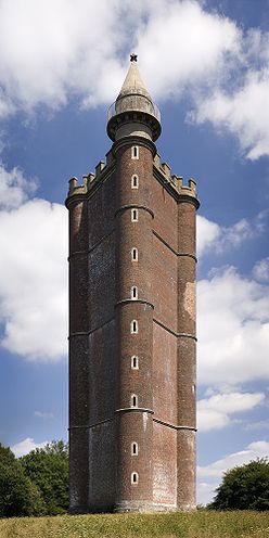
, England. It runs from King Alfred's Tower
in Penselwood
to Ham Hill Country Park
.
during the years 1535 - 1543. In his role as royal librarian, his journeys and tasks during that period were mapped out for him by King Henry VIII
. His job was to reveal to the King all reference to "antiquities
" and possessions of the local churches and priories. The exact route taken by John Leland over much of South Somerset may never be known but what has remained of the records of the time now form the basis of the trail.
 Typical all day walks allow the track to be traversed in manageable stages. Traditionally it is broken down into seven smaller parts.
The walk from Penselwood
to Bruton
, is fairly easy going for 5 miles (8 km) and takes about 3 hours. Then the journey onward to Castle Cary
which takes a little over 2 hours to cover the next 4 miles (6.4 km). The next stage to North Cadbury
will add about another 2 hours to the journey. Queen Camel
is a further 4 miles (6.4 km) and takes just over 2 hours.
The rest of the trail goes from Queen Camel
to Ilchester
covers mainly level ground and takes about 2 hours for a distance of 5 miles (8 km) miles. Montacute
is the next "port of call" enroute, the slightly more difficult terrain will need well over two hours to complete the next 4 miles (6.4 km). Ham Hill, which is the end of the trail takes another hour.
 The forest of Penselwood
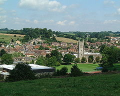
. Bruton
has its packhorse bridge
, dovecote
and famous twin-towered church. Near Castle Cary is Cadbury Castle
whose summit offers a spectacular panorama of the South Somerset countryside. The busy military airfield at Yeovilton
, is also home to the Fleet Air Arm Museum
. Montacute House
is also close to the site of a the former Cluniac Montacute Priory
. At Ham Hill Country Park you can view Exmoor
, the Quantock Hills
, and the Bristol Channel
. Looking east is the trails starting point, Alfred's Tower.
at Ilchester and the Liberty Trail
and the River Parrett Trail
at Ham Hill.
Somerset
The ceremonial and non-metropolitan county of Somerset in South West England borders Bristol and Gloucestershire to the north, Wiltshire to the east, Dorset to the south-east, and Devon to the south-west. It is partly bounded to the north and west by the Bristol Channel and the estuary of the...
, England. It runs from King Alfred's Tower
King Alfred's Tower
King Alfred's Tower or The Folly of King Alfred the Great is in the parish of Brewham, Somerset, and was built as part of the celebrated Stourhead estate and landscape. The tower stands on Kingsettle Hill and nowadays belongs to the National Trust...
in Penselwood
Penselwood
Penselwood is a village and civil parish in the English county of Somerset. It is located north east of Wincanton, south east of Bruton, west of Mere, and north west of Gillingham. The south-east of the parish borders Zeals and Stourhead in Wiltshire, and Bourton in Dorset...
to Ham Hill Country Park
Ham Hill Country Park
Ham Hill is a geological Site of Special Scientific Interest , Scheduled Ancient Monument, Iron Age hill fort, Roman site, Local Nature Reserve and country park, to the west of Yeovil in Somerset, England....
.
History
The path was established by creating rights of way via tracks and lanes. It is named after John Leland who visited South SomersetSouth Somerset
South Somerset is a local government district in Somerset, England.The South Somerset district covers and area of ranging from the borders with Devon and Dorset to the edge of the Somerset Levels. It has a population of approximately 158,000...
during the years 1535 - 1543. In his role as royal librarian, his journeys and tasks during that period were mapped out for him by King Henry VIII
Henry VIII of England
Henry VIII was King of England from 21 April 1509 until his death. He was Lord, and later King, of Ireland, as well as continuing the nominal claim by the English monarchs to the Kingdom of France...
. His job was to reveal to the King all reference to "antiquities
Antiquities
Antiquities, nearly always used in the plural in this sense, is a term for objects from Antiquity, especially the civilizations of the Mediterranean: the Classical antiquity of Greece and Rome, Ancient Egypt and the other Ancient Near Eastern cultures...
" and possessions of the local churches and priories. The exact route taken by John Leland over much of South Somerset may never be known but what has remained of the records of the time now form the basis of the trail.
Route
The walk from Penselwood
Penselwood
Penselwood is a village and civil parish in the English county of Somerset. It is located north east of Wincanton, south east of Bruton, west of Mere, and north west of Gillingham. The south-east of the parish borders Zeals and Stourhead in Wiltshire, and Bourton in Dorset...
to Bruton
Bruton
Bruton is a town and civil parish in Somerset, England, situated on the River Brue seven miles south-east of Shepton Mallet, just south of Snakelake Hill and Coombe Hill, ten miles north-west of Gillingham and twelve miles south-west of Frome in the South Somerset district. The town has a...
, is fairly easy going for 5 miles (8 km) and takes about 3 hours. Then the journey onward to Castle Cary
Castle Cary
Castle Cary is a market town and civil parish in south Somerset, England, north west of Wincanton and south of Shepton Mallet.The town is situated on the River Cary, a tributary of the Parrett.-History:...
which takes a little over 2 hours to cover the next 4 miles (6.4 km). The next stage to North Cadbury
North Cadbury
North Cadbury is a village west of Wincanton in the River Cam in the South Somerset district of Somerset, England. It shares its parish with nearby Yarlington and includes the village of Galhampton, which got its name from the settlement of the rent-paying peasants, and the hamlet of...
will add about another 2 hours to the journey. Queen Camel
Queen Camel
Queen Camel is a village and civil parish, on the River Cam and the A359 road, in the South Somerset district of Somerset, England. It is about north of Yeovil. According to the 2001 census it had a population of 926. The parish includes the hamlet of Wales...
is a further 4 miles (6.4 km) and takes just over 2 hours.
The rest of the trail goes from Queen Camel
Queen Camel
Queen Camel is a village and civil parish, on the River Cam and the A359 road, in the South Somerset district of Somerset, England. It is about north of Yeovil. According to the 2001 census it had a population of 926. The parish includes the hamlet of Wales...
to Ilchester
Ilchester
Ilchester is a village and civil parish, situated on the River Yeo or Ivel, five miles north of Yeovil, in the English county of Somerset. The parish, which includes the village of Sock Dennis and the old parish of Northover, has a population of 2,021...
covers mainly level ground and takes about 2 hours for a distance of 5 miles (8 km) miles. Montacute
Montacute
Montacute is a small village and civil parish in Somerset, England, west of Yeovil. The village has a population of 680 . The name Montacute is thought by some to derive from the Latin "Mons Acutus", referring to the small but still quite acute hill dominating the village to the west.The village...
is the next "port of call" enroute, the slightly more difficult terrain will need well over two hours to complete the next 4 miles (6.4 km). Ham Hill, which is the end of the trail takes another hour.
Places of interest
Penselwood
Penselwood is a village and civil parish in the English county of Somerset. It is located north east of Wincanton, south east of Bruton, west of Mere, and north west of Gillingham. The south-east of the parish borders Zeals and Stourhead in Wiltshire, and Bourton in Dorset...
. Bruton
Bruton
Bruton is a town and civil parish in Somerset, England, situated on the River Brue seven miles south-east of Shepton Mallet, just south of Snakelake Hill and Coombe Hill, ten miles north-west of Gillingham and twelve miles south-west of Frome in the South Somerset district. The town has a...
has its packhorse bridge
Packhorse bridge
A packhorse bridge is a bridge intended to carry packhorses across a river or stream. Typically a packhorse bridge consists of one or more narrow masonry arches, and has low parapets so as not to interfere with the horse's panniers.Packhorse bridges were often built on the trade routes that...
, dovecote
Dovecote
A dovecote or dovecot is a structure intended to house pigeons or doves. Dovecotes may be square or circular free-standing structures or built into the end of a house or barn. They generally contain pigeonholes for the birds to nest. Pigeons and doves were an important food source historically in...
and famous twin-towered church. Near Castle Cary is Cadbury Castle
Cadbury Castle, Somerset
Cadbury Castle is an Iron Age hill fort in the civil parish of South Cadbury in the English county of Somerset. It is a Scheduled Ancient Monument and associated with King Arthur.-Background:...
whose summit offers a spectacular panorama of the South Somerset countryside. The busy military airfield at Yeovilton
Yeovilton
Yeovilton is a village and civil parish in Somerset, England, situated east of Ilchester, north of Yeovil, in the South Somerset district. The village has a population of approximately 670....
, is also home to the Fleet Air Arm Museum
Fleet Air Arm Museum
The Fleet Air Arm Museum is located north of Yeovil, and south of Bristol. It has an extensive collection of military and civilian aircraft, as well as models of Royal Navy ships, especially aircraft carriers. Some of the museum has interactive displays...
. Montacute House
Montacute House
Montacute House is a late Elizabethan country house situated in the South Somerset village of Montacute. This house is a textbook example of English architecture during a period that was moving from the medieval Gothic to the Renaissance Classical; this has resulted in Montacute being regarded as...
is also close to the site of a the former Cluniac Montacute Priory
Montacute Priory
Montacute Priory was a Cluniac priory of the Benedictine order in Montacute, Somerset, England, founded between 1078 and 1102 by William, Count of Mortain, in face of a threat that if he did not do so, the King would take the land from him. It was the only Somerset dependency of Cluny Abbey until...
. At Ham Hill Country Park you can view Exmoor
Exmoor
Exmoor is an area of hilly open moorland in west Somerset and north Devon in South West England, named after the main river that flows out of the district, the River Exe. The moor has given its name to a National Park, which includes the Brendon Hills, the East Lyn Valley, the Vale of Porlock and ...
, the Quantock Hills
Quantock Hills
The Quantock Hills is a range of hills west of Bridgwater in Somerset, England. The Quantock Hills were England’s first Area of Outstanding Natural Beauty being designated in 1956 and consists of large amounts of heathland, oak woodlands, ancient parklands and agricultural land.The hills run from...
, and the Bristol Channel
Bristol Channel
The Bristol Channel is a major inlet in the island of Great Britain, separating South Wales from Devon and Somerset in South West England. It extends from the lower estuary of the River Severn to the North Atlantic Ocean...
. Looking east is the trails starting point, Alfred's Tower.
Intersecting trails
The Leland Trail links with the Monarch's WayMonarch's Way
The Monarch's Way is a long-distance footpath in England that approximates the escape route taken by King Charles II in 1651 after being defeated in the Battle of Worcester.Most of the footpath is waymarked...
at Ilchester and the Liberty Trail
Liberty Trail
A 28-mile trail between Ham Hill in Somerset and Lyme Regis in Dorset, England.-History:The route of the Liberty Trail route is based on information recorded by six rebels from various villages in Somerset and Dorset. Villagers from the two counties made their way to join the Protestant Monmouth...
and the River Parrett Trail
River Parrett Trail
The River Parrett Trail is a long-distance footpath, following the route of the River Parrett in Somerset, England. The trail, which is long, runs from Chedington in Dorset to the mouth of the river in Bridgwater Bay where it joins the West Somerset Coast Path....
at Ham Hill.