
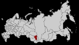
Geography of South-Central Siberia
Encyclopedia
This article covers the region of Siberia
west of Lake Baikal
and north of the Altai Mountains. It is intended to
tie together a number of articles that are hard to understand in isolation.
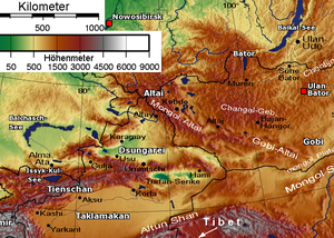
The map at right shows the Kemerovo Oblast
which runs from the Altai Republic
in the south to the Kuznetsk
Alatau Mountains in the north. It is a belt of mountains with steppe on both sides. Since this line makes a convenient landmark, we will look first at the Altai, then the
Kuznetsk Alatau and then the west and east sides of the line. The line separates the upper basins of the Ob
and Yenisei Rivers.
.svg.png)
, China
, Mongolia
and
Kazakhstan
come together to form an X in the Altai Mountains. Mongolia and Kazakhstan do not touch but are separated by a 40 km Russo-Chinese
border. North of the X is the Russian Altai. South of the X is the Altay Prefecture
(need check) of Dzungaria
in
Xinjiang
China. East of the X is the Tavan Bogd Uul in the
Bayan-Ölgii Province of Mongolia
. West of the X is the East Kazakhstan Province of Kazakhstan
.
Only the eastern tip of this province is mountainous.
The Irtysh River flows northwest from
Dzungaria through the steppe on the southwest side of the X.
(not to be confused with the Altai Krai
to the northwest). It contains
the central knot to the Altai Mountains. The area is very mountainous and still has few good roads. It was inhabited by various Turkic groups who gradually became the Altay people
. As the surrounding steppes filled with Russians, many of the lowland Turks were Russified or retreated to the mountains. It only came under definitive Russian control in the 1860s. The M52 highway (Russia)
runs northwest from here.
Abakan Range
in the south(need boundray) and Kuznetsk Alatau
in the north. The name (Kuznets=blacksmith) comes from the 'Blacksmith Tatars' or
Shors
, who were notable metal workers. The Russians reached the area as early as 1618. The Abakans, Kuznetsk Alatau and the Kuznetsk
Basin form the Kemerovo Oblast
with its mostly Russian population.
extends northwest from the Abakans forming a sort to thumb. Between the 'thumb' and the 'fingers' is the
steppe of the Kuznetsk Depression
, which contains the large Kuznetsk Basin
coal fields.
Tom River
drains the east side of the basin and joins the Ob River
north of Tomsk
. The town of Novokuznetsk
was founded in 1618
To the west of this is the agricultural steppe of the Altai Krai
with its Russian population.
Here Katun River and Biya River
s join to form the Ob River
.
Further west, between the Ob and Irtysh River are the Baraba steppe
in the north and the Kalunda Steppe in the south.
flows north through its center.
The Abakan River
flows from the base of the depression north and slightly east to the Yenisei at Abakan
town, near where a (name?) river comes in from the east. Minusinsk
town is a few miles east of Abakan.
The Chulym River (Ob River)
starts in the northwest corner of the depression, arcs into the Taiga north of the Alatau and joins the Ob River
. Between the mountains and the
Yenisei is the Khakassia
republic. East of the river is the southern tip of Krasnoyarsk Krai
.
This area was a centre of the Afanasevo culture
, a suggested homeland for the Tocharians
.
Later it was the home of the Yenisei Kirghiz
, who gave their name to the Kirgiz further south.
The Khakas
of Khakassia may be their descendents.
East of Minusinsk are the Sayan Mountains
which form a twisted 'T'. The Eastern Sayans run from the upper Minusinsk Depression
about 650 km east and slightly south almost to the tip of Lake Baikal
. The Western Sayans run northeast from the Altai about 600 km and
meet the Eastern Sayans near their western end, separating the Minusinsk Depression from Tuva.
North of the Sayans is mostly permafrost and Taiga
with a few patches of steppe around Lake Baikal. Here the proper steppe is south of the border in Mongolia.
. Tuva is bounded on the south by the
Tannu-Ola Mountains
, which separate it from the Mongolian Great Lakes Depression
, on the west by the Altai, on the northwest by the Western Sayans which separate it from the Minusinsk Depression, on the north by the Eastern Sayans and on the east by (name?) mountains on the Mongolian border.
The core area is the Tuva Depression
with the capital Kyzyl
. The Yenisei River
flows west here and then breaks through the Western Sayans in a long narrow gorge which contains the Sayano-Shushenskaya Dam north of the Tuva border. Tuva is somewhat boot-shaped facing west. The shank of the boot is separated from the Tuva Depression by the (name?) mountains. Tuva was traditionally part of Mongolia and only passed to Russian in the 20th century.
Tomsk
is about 50 km north of the Kuznetsk Alatau.
Novosibirsk
is about 100 km northwest of the Salair 'thumb' on the Ob River.
Krasnoyarsk
is about 100 km north of the Minusinsk Depression on the Yenesei.
The Trans-Siberian Railway
runs from Novosibirsk
to Krasnoyarsk
.
There is a parallel line to the south.
Forest and Steppe: The area to the west is steppe or forest-steppe. The steppe curves around north of
the Kuznetsk Alatau into the Minusinsk Depression. The land to the north and east is Taiga
.
The Russians first entered the area about 1620. Seeking furs, they stayed in the forest area to the north. Massive peasant colonization of the steppe
area only began after about 1860.
Orphan Articles: The following places are in the area and need to have their exact location established:
Ukok Plateau
Saylyugem Mountains
Lake Kanas
Darkhad valley
Pazyryk
Siberia
Siberia is an extensive region constituting almost all of Northern Asia. Comprising the central and eastern portion of the Russian Federation, it was part of the Soviet Union from its beginning, as its predecessor states, the Tsardom of Russia and the Russian Empire, conquered it during the 16th...
west of Lake Baikal
Lake Baikal
Lake Baikal is the world's oldest at 30 million years old and deepest lake with an average depth of 744.4 metres.Located in the south of the Russian region of Siberia, between Irkutsk Oblast to the northwest and the Buryat Republic to the southeast, it is the most voluminous freshwater lake in the...
and north of the Altai Mountains. It is intended to
tie together a number of articles that are hard to understand in isolation.
The map at right shows the Kemerovo Oblast
Kemerovo Oblast
Kemerovo Oblast , also known as Kuzbass after the Kuznetsk Basin, is a federal subject of Russia , located in southwestern Siberia, where the West Siberian Plain meets the South Siberian mountains...
which runs from the Altai Republic
Altai Republic
Altai Republic is a federal subject of Russia . Its capital is the town of Gorno-Altaysk. The area of the republic is . Population: -Geography:...
in the south to the Kuznetsk
Kuznetsk
Kuznetsk is a town in Penza Oblast, Russia, located east of Penza and west of Samara and the Volga River. Population: -External links:*...
Alatau Mountains in the north. It is a belt of mountains with steppe on both sides. Since this line makes a convenient landmark, we will look first at the Altai, then the
Kuznetsk Alatau and then the west and east sides of the line. The line separates the upper basins of the Ob
Ob River
The Ob River , also Obi, is a major river in western Siberia, Russia and is the world's seventh longest river. It is the westernmost of the three great Siberian rivers that flow into the Arctic Ocean .The Gulf of Ob is the world's longest estuary.-Names:The Ob is known to the Khanty people as the...
and Yenisei Rivers.
The Four Corners
At about 88 degrees east the borders of RussiaRussia
Russia or , officially known as both Russia and the Russian Federation , is a country in northern Eurasia. It is a federal semi-presidential republic, comprising 83 federal subjects...
, China
China
Chinese civilization may refer to:* China for more general discussion of the country.* Chinese culture* Greater China, the transnational community of ethnic Chinese.* History of China* Sinosphere, the area historically affected by Chinese culture...
, Mongolia
Mongolia
Mongolia is a landlocked country in East and Central Asia. It is bordered by Russia to the north and China to the south, east and west. Although Mongolia does not share a border with Kazakhstan, its western-most point is only from Kazakhstan's eastern tip. Ulan Bator, the capital and largest...
and
Kazakhstan
Kazakhstan
Kazakhstan , officially the Republic of Kazakhstan, is a transcontinental country in Central Asia and Eastern Europe. Ranked as the ninth largest country in the world, it is also the world's largest landlocked country; its territory of is greater than Western Europe...
come together to form an X in the Altai Mountains. Mongolia and Kazakhstan do not touch but are separated by a 40 km Russo-Chinese
border. North of the X is the Russian Altai. South of the X is the Altay Prefecture
Altay Prefecture
Altay Prefecture is located in northern Xinjiang, China. It has an area of 118,015 km² and a population of 561,667 . It is a part of Ili Kazakh Autonomous Prefecture...
(need check) of Dzungaria
Dzungaria
Dzungaria, also called Zungaria, is a geographical region in northwest China corresponding to the northern half of Xinjiang. It covers approximately , lying mostly within Xinjiang, and extending into western Mongolia and eastern Kazakhstan...
in
Xinjiang
Xinjiang
Xinjiang is an autonomous region of the People's Republic of China. It is the largest Chinese administrative division and spans over 1.6 million km2...
China. East of the X is the Tavan Bogd Uul in the
Bayan-Ölgii Province of Mongolia
Mongolia
Mongolia is a landlocked country in East and Central Asia. It is bordered by Russia to the north and China to the south, east and west. Although Mongolia does not share a border with Kazakhstan, its western-most point is only from Kazakhstan's eastern tip. Ulan Bator, the capital and largest...
. West of the X is the East Kazakhstan Province of Kazakhstan
Kazakhstan
Kazakhstan , officially the Republic of Kazakhstan, is a transcontinental country in Central Asia and Eastern Europe. Ranked as the ninth largest country in the world, it is also the world's largest landlocked country; its territory of is greater than Western Europe...
.
Only the eastern tip of this province is mountainous.
The Irtysh River flows northwest from
Dzungaria through the steppe on the southwest side of the X.
South: Altai Republic
At the top of the X is the Altai RepublicAltai Republic
Altai Republic is a federal subject of Russia . Its capital is the town of Gorno-Altaysk. The area of the republic is . Population: -Geography:...
(not to be confused with the Altai Krai
Altai Krai
Altai Krai is a federal subject of Russia . It borders with, clockwise from the south, Kazakhstan, Novosibirsk and Kemerovo Oblasts, and the Altai Republic. The krai's administrative center is the city of Barnaul...
to the northwest). It contains
the central knot to the Altai Mountains. The area is very mountainous and still has few good roads. It was inhabited by various Turkic groups who gradually became the Altay people
Altay people
The Altay or Altai are an ethnic group of Turkic people living in the Siberian Altai Republic and Altai Krai and surrounding areas of Tuva and Mongolia. For alternative ethnonyms see also Teleut, Tele, Telengit, Mountain Kalmuck, White Kalmuck, Black Tatar, Oirat/Oirot.The Uriankhai people were...
. As the surrounding steppes filled with Russians, many of the lowland Turks were Russified or retreated to the mountains. It only came under definitive Russian control in the 1860s. The M52 highway (Russia)
M52 highway (Russia)
The Russian route M52, also known as Chuya Highway or Chuysky Trakt , is a trunk road in Novosibirsk Oblast, Altai Krai and Altai Republic of Russia. Its length is 953 kilometres...
runs northwest from here.
North: Abakans and Kuznetsk Alatau
North of the Altai is the 400 km projection of forested mountains which bends slightly to the west at the tip. It is called theAbakan Range
Abakan Range
Abakan Range is a metamorphic rock mountain range in the Southwestern Siberia, Russia: length: , elevation: up to . It is mostly covered by taiga, up to , followed by mountainous tundra....
in the south(need boundray) and Kuznetsk Alatau
Kuznetsk Alatau
Kuznetsk Alatau is a mountain range, South Siberia, Russia between Kuznetsk Depression and Minusinsk Depression. Length: about 300 km., elevation: up to . It is part of the mountain system of Central Asia. See Geography of South-Central Siberia....
in the north. The name (Kuznets=blacksmith) comes from the 'Blacksmith Tatars' or
Shors
Shors
Shors or Shorians are a Turkic people in the Kemerovo Oblast in Russia. Their self designation is Шор, or Shor. They were also called Kuznetskie Tatars , Kondoma Tatars , Mras-Su Tatars in some of the documents of the 17th-18th centuries.Most of Shors live in the Tom basin along the Kondoma and...
, who were notable metal workers. The Russians reached the area as early as 1618. The Abakans, Kuznetsk Alatau and the Kuznetsk
Basin form the Kemerovo Oblast
Kemerovo Oblast
Kemerovo Oblast , also known as Kuzbass after the Kuznetsk Basin, is a federal subject of Russia , located in southwestern Siberia, where the West Siberian Plain meets the South Siberian mountains...
with its mostly Russian population.
West: Kuznetsk Depression
The Salair RidgeSalair Ridge
Salair Ridge is an eroded plateau-type highland in the Southwestern Siberia, Russia, particularly in Altai Krai, Kemerovo and Novosibirsk Oblast. It is a natural continuation of Altai Mountains and separates the Kuznetsk Depression from the Ob River Plain to the southwest. See Geography of...
extends northwest from the Abakans forming a sort to thumb. Between the 'thumb' and the 'fingers' is the
steppe of the Kuznetsk Depression
Kuznetsk Depression
Kuznetsk Depression is located among mountains of Southern Siberia: Kuznetsk Alatau to the Northeast, Salair Ridge to the Southwest, and Mountainous Shoria to the South. Elevation up to 500 m, area: 70,000 km², length: 400 km, width: 120 km....
, which contains the large Kuznetsk Basin
Kuznetsk Basin
The Kuznetsk Basin in southwestern Siberia, Russia, is one of the largest coal mining areas in the world, covering an area of around . It lies in the Kuznetsk Depression between Tomsk and Novokuznetsk in the basin of the Tom River...
coal fields.
Tom River
Tom River
Tom is a river in Russia, a right tributary of the Ob. Its length is 540 miles . Its source is in the Abakan mountains , and it flows northward through the Kuznetsk Basin...
drains the east side of the basin and joins the Ob River
Ob River
The Ob River , also Obi, is a major river in western Siberia, Russia and is the world's seventh longest river. It is the westernmost of the three great Siberian rivers that flow into the Arctic Ocean .The Gulf of Ob is the world's longest estuary.-Names:The Ob is known to the Khanty people as the...
north of Tomsk
Tomsk
Tomsk is a city and the administrative center of Tomsk Oblast, Russia, located on the Tom River. One of the oldest towns in Siberia, Tomsk celebrated its 400th anniversary in 2004...
. The town of Novokuznetsk
Novokuznetsk
Novokuznetsk is a city in Kemerovo Oblast, Russia. It serves as the administrative center of Novokuznetsky District, but it is not administratively a part of it...
was founded in 1618
To the west of this is the agricultural steppe of the Altai Krai
Altai Krai
Altai Krai is a federal subject of Russia . It borders with, clockwise from the south, Kazakhstan, Novosibirsk and Kemerovo Oblasts, and the Altai Republic. The krai's administrative center is the city of Barnaul...
with its Russian population.
Here Katun River and Biya River
Biya River
The Biya River is a river in the Altai Republic and Altai Krai in Russia. It forms the Ob River as it joins the Katun River. The Biya River is 301 km long; the area of its drainage basin is 37,000 km². It flows out of the Teletskoye Lake. The river freezes up in the mid-November to early December...
s join to form the Ob River
Ob River
The Ob River , also Obi, is a major river in western Siberia, Russia and is the world's seventh longest river. It is the westernmost of the three great Siberian rivers that flow into the Arctic Ocean .The Gulf of Ob is the world's longest estuary.-Names:The Ob is known to the Khanty people as the...
.
Further west, between the Ob and Irtysh River are the Baraba steppe
Baraba steppe
The Baraba steppe, also known as Barabinsk steppe, , is a grassland steppe and wooded flat plain situated in western Siberia.The steppe has an area of 117,000 km² and stretches between the Irtysh and the Ob Rivers. Barabinsk is the largest city on the steppe. The Baraba steppe also contains...
in the north and the Kalunda Steppe in the south.
East: Minusinsk Depression
To the east, between the Kuznetsk Alatau and the Sayans, is the steppe of the Minusinsk Depression. The Yenisei RiverYenisei River
Yenisei , also written as Yenisey, is the largest river system flowing to the Arctic Ocean. It is the central of the three great Siberian rivers that flow into the Arctic Ocean...
flows north through its center.
The Abakan River
Abakan River
The Abakan , the Khakas word for 'bear's blood', is a river in the Republic of Khakassia, Russia formed by the confluence of the Bolshoy Abakan and Maly Abakan Rivers. It rises in the western Sayan Mountains and flows northeast through the Minusinsk Depression to the Yenisei River...
flows from the base of the depression north and slightly east to the Yenisei at Abakan
Abakan
Abakan is the capital city of the Republic of Khakassia, Russia, located in the central part of Minusinsk Depression, at the confluence of the Yenisei and Abakan Rivers. Population: -History:...
town, near where a (name?) river comes in from the east. Minusinsk
Minusinsk
Minusinsk is a historic town in Krasnoyarsk Krai, Russia. It serves as the administrative center of Minusinsky District, although it is not administratively a part of it. Population: 44,500 ....
town is a few miles east of Abakan.
The Chulym River (Ob River)
Chulym River (Ob River)
The Chulym is a river in Krasnoyarsk Krai and Tomsk Oblast in Russia, a right tributary of the Ob River. The length of the river is . The area of its basin is . The Chulym flows into the Ob in Ust-Chulym...
starts in the northwest corner of the depression, arcs into the Taiga north of the Alatau and joins the Ob River
Ob River
The Ob River , also Obi, is a major river in western Siberia, Russia and is the world's seventh longest river. It is the westernmost of the three great Siberian rivers that flow into the Arctic Ocean .The Gulf of Ob is the world's longest estuary.-Names:The Ob is known to the Khanty people as the...
. Between the mountains and the
Yenisei is the Khakassia
Khakassia
The Republic of Khakassia or Khakasiya is a federal subject of Russia located in south-central Siberia. Its capital city is Abakan, which is also the largest city in the republic...
republic. East of the river is the southern tip of Krasnoyarsk Krai
Krasnoyarsk Krai
Krasnoyarsk Krai is a federal subject of Russia . It is the second largest federal subject after the Sakha Republic, and Russia's largest krai, occupying an area of , which is 13% of the country's total territory. The administrative center of the krai is the city of Krasnoyarsk...
.
This area was a centre of the Afanasevo culture
Afanasevo culture
The Afanasevo culture, traditionally dated to 2500–2000 BC , is an archaeological culture of the late copper and early Bronze Age of southern Siberia....
, a suggested homeland for the Tocharians
Tocharian languages
Tocharian or Tokharian is an extinct branch of the Indo-European language family. The name is taken from the people known to the Greeks as the Tocharians . These are sometimes identified with the Yuezhi and the Kushans. The term Tokharistan usually refers to 1st millennium Bactria, which the...
.
Later it was the home of the Yenisei Kirghiz
Yenisei Kirghiz
The Yenisei Kirghiz, also known as the Khyagas or Khakas, were an ancient people that dwelled along the upper Yenisei River in the southern portion of the Minusinsk Depression from the 3rd century BCE to the 13th century CE...
, who gave their name to the Kirgiz further south.
The Khakas
Khakas
The Khakas, or Khakass , are a Turkic-speaking people, who live in Russia, in the republic of Khakassia in southern Siberia. They speak the Khakas language.The origin of the Khakas people is disputed...
of Khakassia may be their descendents.
East of Minusinsk are the Sayan Mountains
Sayan Mountains
The Sayan Mountains are a mountain range between northwestern Mongolia and southern Siberia, Russia.The Eastern Sayan extends from the Yenisei River at 92° E to the southwest end of Lake Baikal at 106° E...
which form a twisted 'T'. The Eastern Sayans run from the upper Minusinsk Depression
about 650 km east and slightly south almost to the tip of Lake Baikal
Lake Baikal
Lake Baikal is the world's oldest at 30 million years old and deepest lake with an average depth of 744.4 metres.Located in the south of the Russian region of Siberia, between Irkutsk Oblast to the northwest and the Buryat Republic to the southeast, it is the most voluminous freshwater lake in the...
. The Western Sayans run northeast from the Altai about 600 km and
meet the Eastern Sayans near their western end, separating the Minusinsk Depression from Tuva.
North of the Sayans is mostly permafrost and Taiga
Taiga
Taiga , also known as the boreal forest, is a biome characterized by coniferous forests.Taiga is the world's largest terrestrial biome. In North America it covers most of inland Canada and Alaska as well as parts of the extreme northern continental United States and is known as the Northwoods...
with a few patches of steppe around Lake Baikal. Here the proper steppe is south of the border in Mongolia.
Southeast: Tuva
East of the Altai and southeast of Minusinsk is TuvaTuva
The Tyva Republic , or Tuva , is a federal subject of Russia . It lies in the geographical center of Asia, in southern Siberia. The republic borders with the Altai Republic, the Republic of Khakassia, Krasnoyarsk Krai, Irkutsk Oblast, and the Republic of Buryatia in Russia and with Mongolia to the...
. Tuva is bounded on the south by the
Tannu-Ola Mountains
Tannu-Ola Mountains
The Tannu-Ola mountains is a mountain range in southern Siberia, in the Tuva Republic of Russia. It extends in an east-west direction and curves along the Mongolian border...
, which separate it from the Mongolian Great Lakes Depression
Great Lakes Depression
The Great Lakes Depression is a large semi-arid depression in Mongolia that covers parts of the Uvs, Khovd, Zavkhan and Govi-Altai aimags. Bounded by the Altai in the West, Khangai in the East and Tannu-Ola Mountains in the North,...
, on the west by the Altai, on the northwest by the Western Sayans which separate it from the Minusinsk Depression, on the north by the Eastern Sayans and on the east by (name?) mountains on the Mongolian border.
The core area is the Tuva Depression
Tuva Depression
Tuva Depression is located among mountains of South Central Siberia — Tannu-Ola Mountains, Eastern Sayans and Western Sayans, and the Altay Mountains region, part of a combination of raised lands and depressions....
with the capital Kyzyl
Kyzyl
-External links:*** in Kyzyl, Russia*...
. The Yenisei River
Yenisei River
Yenisei , also written as Yenisey, is the largest river system flowing to the Arctic Ocean. It is the central of the three great Siberian rivers that flow into the Arctic Ocean...
flows west here and then breaks through the Western Sayans in a long narrow gorge which contains the Sayano-Shushenskaya Dam north of the Tuva border. Tuva is somewhat boot-shaped facing west. The shank of the boot is separated from the Tuva Depression by the (name?) mountains. Tuva was traditionally part of Mongolia and only passed to Russian in the 20th century.
Also
Large Towns:Tomsk
Tomsk
Tomsk is a city and the administrative center of Tomsk Oblast, Russia, located on the Tom River. One of the oldest towns in Siberia, Tomsk celebrated its 400th anniversary in 2004...
is about 50 km north of the Kuznetsk Alatau.
Novosibirsk
Novosibirsk
Novosibirsk is the third-largest city in Russia, after Moscow and Saint Petersburg, and the largest city of Siberia, with a population of 1,473,737 . It is the administrative center of Novosibirsk Oblast as well as of the Siberian Federal District...
is about 100 km northwest of the Salair 'thumb' on the Ob River.
Krasnoyarsk
Krasnoyarsk
Krasnoyarsk is a city and the administrative center of Krasnoyarsk Krai, Russia, located on the Yenisei River. It is the third largest city in Siberia, with the population of 973,891. Krasnoyarsk is an important junction of the Trans-Siberian Railway and one of Russia's largest producers of...
is about 100 km north of the Minusinsk Depression on the Yenesei.
The Trans-Siberian Railway
Trans-Siberian Railway
The Trans-Siberian Railway is a network of railways connecting Moscow with the Russian Far East and the Sea of Japan. It is the longest railway in the world...
runs from Novosibirsk
Novosibirsk
Novosibirsk is the third-largest city in Russia, after Moscow and Saint Petersburg, and the largest city of Siberia, with a population of 1,473,737 . It is the administrative center of Novosibirsk Oblast as well as of the Siberian Federal District...
to Krasnoyarsk
Krasnoyarsk
Krasnoyarsk is a city and the administrative center of Krasnoyarsk Krai, Russia, located on the Yenisei River. It is the third largest city in Siberia, with the population of 973,891. Krasnoyarsk is an important junction of the Trans-Siberian Railway and one of Russia's largest producers of...
.
There is a parallel line to the south.
Forest and Steppe: The area to the west is steppe or forest-steppe. The steppe curves around north of
the Kuznetsk Alatau into the Minusinsk Depression. The land to the north and east is Taiga
Taiga
Taiga , also known as the boreal forest, is a biome characterized by coniferous forests.Taiga is the world's largest terrestrial biome. In North America it covers most of inland Canada and Alaska as well as parts of the extreme northern continental United States and is known as the Northwoods...
.
The Russians first entered the area about 1620. Seeking furs, they stayed in the forest area to the north. Massive peasant colonization of the steppe
area only began after about 1860.
Orphan Articles: The following places are in the area and need to have their exact location established:
Ukok Plateau
Ukok Plateau
Ukok Plateau is a remote and pristine grasslands area located in the heart of southwestern Siberia, the Altai Mountains region of Russia near the borders with China, Kazakhstan and Mongolia...
Saylyugem Mountains
Saylyugem Mountains
Saylyugem Mountains is a mountain range in the Southeastern part of Altai Mountains. The range stretches 130 km northeast from 49° N and 86° E towards the western extremity of the Sayan Mountains in 51° 60' N and 89° E. Their mean elevation is 1,500 to 1,750 m...
Lake Kanas
Lake Kanas
Kanas Lake is a lake in Altay Prefecture, Xinjiang, China. The lake is located in a valley in the Altai Mountains, near the very northern tip of Xinjiang, and the province's borders with Kazakhstan, Mongolia, and Russia. The lake was born around 200, 000 years ago during the Quaternary period,...
Darkhad valley
Darkhad valley
The Darkhad valley is a large valley in northwestern Khövsgöl aimag, Mongolia. It is situated between the Ulaan Taiga and Khoridol Saridag ranges at an altitude of about 1600 m, about 160 km long and 40 km wide. The area is 4270 km²...
Pazyryk
Pazyryk
The Pazyryk burials are a number of Iron Age tombs found in the Pazyryk Valley of the Ukok plateau in the Altai Mountains, Siberia, south of the modern city of Novosibirsk, Russia; the site is close to the borders with China, Kazakhstan and Mongolia.The tombs are Scythian kurgans, that is...