
Geography of Poland
Encyclopedia
Poland
Poland , officially the Republic of Poland , is a country in Central Europe bordered by Germany to the west; the Czech Republic and Slovakia to the south; Ukraine, Belarus and Lithuania to the east; and the Baltic Sea and Kaliningrad Oblast, a Russian exclave, to the north...
is a country in Central Europe
Central Europe
Central Europe or alternatively Middle Europe is a region of the European continent lying between the variously defined areas of Eastern and Western Europe...
with an area of 312,679 square kilometres (120,726 sq mi), and mostly temperate climate. Generally speaking, Poland is an almost unbroken plain reaching from the Baltic Sea
Baltic Sea
The Baltic Sea is a brackish mediterranean sea located in Northern Europe, from 53°N to 66°N latitude and from 20°E to 26°E longitude. It is bounded by the Scandinavian Peninsula, the mainland of Europe, and the Danish islands. It drains into the Kattegat by way of the Øresund, the Great Belt and...
in the north, to the Carpathian Mountains
Carpathian Mountains
The Carpathian Mountains or Carpathians are a range of mountains forming an arc roughly long across Central and Eastern Europe, making them the second-longest mountain range in Europe...
in the south. Within that plain, terrain variations run in bands east to west.
The Baltic coast has two natural harbor
Harbor
A harbor or harbour , or haven, is a place where ships, boats, and barges can seek shelter from stormy weather, or else are stored for future use. Harbors can be natural or artificial...
s, the larger one in the Gdańsk-Gdynia
Tricity
Tricity is an urban area consisting of three Polish cities: Gdańsk, Gdynia and Sopot. They are situated adjacent to one other, in a row, on the coast of the Gdańsk Bay, Baltic Sea, in Pomerelia , northern Poland...
region, and a smaller one near Szczecin
Szczecin
Szczecin , is the capital city of the West Pomeranian Voivodeship in Poland. It is the country's seventh-largest city and the largest seaport in Poland on the Baltic Sea. As of June 2009 the population was 406,427....
in the far northwest. The northeastern region called the Masurian Lake District with more than 2,000 lakes, is densely wooded, sparsely populated and lacks agricultural and industrial resources. To the south of the lake district, and across central Poland a vast region of plains extends all the way to the Sudetes
Sudeten mountains
The Sudetes is a mountain range in Central Europe. It is also known as the Sudeten or Sudety Mountains....
on the Czech
Czech Republic
The Czech Republic is a landlocked country in Central Europe. The country is bordered by Poland to the northeast, Slovakia to the east, Austria to the south, and Germany to the west and northwest....
and Slovak
Slovakia
The Slovak Republic is a landlocked state in Central Europe. It has a population of over five million and an area of about . Slovakia is bordered by the Czech Republic and Austria to the west, Poland to the north, Ukraine to the east and Hungary to the south...
borders southwest, and to the Carpathians
Carpathian Mountains
The Carpathian Mountains or Carpathians are a range of mountains forming an arc roughly long across Central and Eastern Europe, making them the second-longest mountain range in Europe...
on the Czech, Slovak and Ukrainian
Ukraine
Ukraine is a country in Eastern Europe. It has an area of 603,628 km², making it the second largest contiguous country on the European continent, after Russia...
borders southeast. The central lowlands had been formed by glacial erosion in the Pleistocene
Pleistocene
The Pleistocene is the epoch from 2,588,000 to 11,700 years BP that spans the world's recent period of repeated glaciations. The name pleistocene is derived from the Greek and ....
ice age
Ice age
An ice age or, more precisely, glacial age, is a generic geological period of long-term reduction in the temperature of the Earth's surface and atmosphere, resulting in the presence or expansion of continental ice sheets, polar ice sheets and alpine glaciers...
. The neighboring countries are Germany to the west, the Czech Republic and Slovakia to the south,
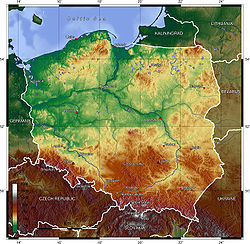
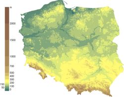
Topography
The country extends 876 kilometers from north to south and 689 kilometers from east to west, at an area of 564,5897 square kilometers including inland waters. The average elevationElevation
The elevation of a geographic location is its height above a fixed reference point, most commonly a reference geoid, a mathematical model of the Earth's sea level as an equipotential gravitational surface ....
is 173 meters, and only 3% of Polish territory, along the southern border, is higher than 500 meters. The highest elevation is Mount Rysy
Rysy
Rysy is a mountain in the crest of the High Tatras, lying on the border between Poland and Slovakia. Rysy has three peaks: the middle at ; the north-western at ; and the south-eastern at...
, which rises 2,499 meters in the Tatra
Tatra Mountains
The Tatra Mountains, Tatras or Tatra , are a mountain range which forms a natural border between Slovakia and Poland, and are the highest mountain range in the Carpathian Mountains...
Range of the Carpathians, 95 kilometers south of Kraków
Kraków
Kraków also Krakow, or Cracow , is the second largest and one of the oldest cities in Poland. Situated on the Vistula River in the Lesser Poland region, the city dates back to the 7th century. Kraków has traditionally been one of the leading centres of Polish academic, cultural, and artistic life...
. About 60 square kilometers along the Gulf of Gdańsk are below sea level. Poland is traditionally divided into five topographic
Topography
Topography is the study of Earth's surface shape and features or those ofplanets, moons, and asteroids...
zones from north to south.
The largest, the central lowlands or "Polish Plain" ( or Nizina Polska), is narrow in the west, then expands to the north and south as it extends eastward. Along the eastern border, this zone reaches from the far northeast to within 200 kilometers of the southern border. The terrain in the central lowlands is quite flat, and earlier glacial lakes have been filled by sediment. The region is cut by several major rivers, including the Oder (Odra), which defines the Silesian Lowlands
Silesian Lowlands
Silesian Lowlands are lowlands located in Silesia, Poland and Czechia. It's part of the North European Plain...
in the southwest, and the Vistula (Wisla), which defines the lowland areas of east-central Poland.
To the south of the lowlands are the lesser Poland uplands, a belt varying in width from 90 to 200 kilometers, formed by the gently sloping foothills of the Sudeten and Carpathian mountain ranges and the uplands that connect the ranges in southcentral Poland. The topography of this region is divided transversely into higher and lower elevations, reflecting its underlying geological
Geology
Geology is the science comprising the study of solid Earth, the rocks of which it is composed, and the processes by which it evolves. Geology gives insight into the history of the Earth, as it provides the primary evidence for plate tectonics, the evolutionary history of life, and past climates...
structure. In the western section, the Silesia-Kraków Upthrust contains rich coal
Coal
Coal is a combustible black or brownish-black sedimentary rock usually occurring in rock strata in layers or veins called coal beds or coal seams. The harder forms, such as anthracite coal, can be regarded as metamorphic rock because of later exposure to elevated temperature and pressure...
deposits.
The third topographic area is located on either side of Poland's southern border and is formed by the Sudeten and Carpathian ranges. Within Poland, neither of these ranges is forbidding enough to prevent substantial habitation; the Carpathians are especially densely populated. The rugged form of the Sudeten range derives from the geological shifts that formed the later Carpathian uplift. The highest elevation in the Sudeten is Śnieżka (1,602 meters) in the Karkonosze Mountains. The Carpathians in Poland, formed as a discrete topographical unit in the relatively recent Tertiary Era
Tertiary
The Tertiary is a deprecated term for a geologic period 65 million to 2.6 million years ago. The Tertiary covered the time span between the superseded Secondary period and the Quaternary...
, are the highest mountains in the country. They are the northernmost edge of a much larger range that extends into the Czech Republic, Slovakia, Ukraine, Hungary
Hungary
Hungary , officially the Republic of Hungary , is a landlocked country in Central Europe. It is situated in the Carpathian Basin and is bordered by Slovakia to the north, Ukraine and Romania to the east, Serbia and Croatia to the south, Slovenia to the southwest and Austria to the west. The...
, and Romania
Romania
Romania is a country located at the crossroads of Central and Southeastern Europe, on the Lower Danube, within and outside the Carpathian arch, bordering on the Black Sea...
. Within Poland the range includes two major basins, the Oświęcim
Oswiecim
Oświęcim is a town in the Lesser Poland province of southern Poland, situated west of Kraków, near the confluence of the rivers Vistula and Soła.- History :...
and Sandomierz
Sandomierz
Sandomierz is a city in south-eastern Poland with 25,714 inhabitants . Situated in the Świętokrzyskie Voivodeship , previously in Tarnobrzeg Voivodeship . It is the capital of Sandomierz County . Sandomierz is known for its Old Town, a major tourist attraction...
, which are rich in several minerals and natural gas
Natural gas
Natural gas is a naturally occurring gas mixture consisting primarily of methane, typically with 0–20% higher hydrocarbons . It is found associated with other hydrocarbon fuel, in coal beds, as methane clathrates, and is an important fuel source and a major feedstock for fertilizers.Most natural...
.
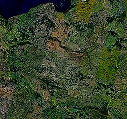
To the north of the central lowlands, the lake region includes the only primeval forests remaining in Europe and much of Poland's shrinking unspoiled natural habitat. Glacial action in this region formed lakes and low hills in the otherwise flat terrain adjacent to Lithuania and the Baltic Sea. Small lakes dot the entire northern half of Poland, and the glacial formations that characterize the lake region extend as much as 200 kilometers inland in western Poland. Wide river valleys divide the lake region into three parts. In the northwest, Pomerania
Pomerania
Pomerania is a historical region on the south shore of the Baltic Sea. Divided between Germany and Poland, it stretches roughly from the Recknitz River near Stralsund in the West, via the Oder River delta near Szczecin, to the mouth of the Vistula River near Gdańsk in the East...
is located south of the Baltic coastal region and north of the Warta
Warta River
The Warta is a river in western-central Poland, a tributary of the Oder river. With a length of approximately it is the country's third longest river. The Warta has a basin area of 54,529 square kilometers...
and Noteć
Notec
Noteć is a river in central Poland with a length of 388 km and a basin area of 17,330 km². It is a tributary of the Warta river and lies completely within Poland....
rivers. Masuria
Masuria
Masuria is an area in northeastern Poland famous for its 2,000 lakes. Geographically, Masuria is part of two adjacent lakeland districts, the Masurian Lake District and the Iława Lake District...
occupies the remainder of northern Poland and features a string of larger lakes. Most of Poland's 9,300 lakes that are more than 10,000 square metres in area are located in the northern part of the lake region, where they occupy about 10 % of the surface area.
The Baltic coastal plains are a low-lying region formed of sediments deposited by the sea. The coastline was shaped by the action of the rising sea after the Scandinavia
Scandinavia
Scandinavia is a cultural, historical and ethno-linguistic region in northern Europe that includes the three kingdoms of Denmark, Norway and Sweden, characterized by their common ethno-cultural heritage and language. Modern Norway and Sweden proper are situated on the Scandinavian Peninsula,...
n ice sheet retreated. The two major inlets in the smooth coast are the Pomeranian Bay on the German border in the far northwest and the Gulf of Gdańsk in the east. The Oder River empties into the former, and the Vistula forms a large delta at the head of the latter. Sandbars with large dunes form lagoons and coastal lakes along much of the coast.
Drainage
Nearly all of Poland is swirled northward into the Baltic Sea by the Vistula, the Oder, and the tributaries of these two major rivers. About half the country is drained by the Vistula, which originates in the Tatra MountainsTatra Mountains
The Tatra Mountains, Tatras or Tatra , are a mountain range which forms a natural border between Slovakia and Poland, and are the highest mountain range in the Carpathian Mountains...
in far south-central Poland. The Vistula Basin includes most of the eastern half of the country and is drained by a system of rivers that mainly join the Vistula from the east. One of the tributaries, the Bug
Bug River
The Bug River is a left tributary of the Narew river flows from central Ukraine to the west, passing along the Ukraine-Polish and Polish-Belarusian border and into Poland, where it empties into the Narew river near Serock. The part between the lake and the Vistula River is sometimes referred to as...
, defines 280 kilometers of Poland's eastern border with Ukraine and Belarus. The Oder and its major tributary, the Warta
Warta River
The Warta is a river in western-central Poland, a tributary of the Oder river. With a length of approximately it is the country's third longest river. The Warta has a basin area of 54,529 square kilometers...
, form a basin that drains the western third of Poland into the bays north of Szczecin
Szczecin
Szczecin , is the capital city of the West Pomeranian Voivodeship in Poland. It is the country's seventh-largest city and the largest seaport in Poland on the Baltic Sea. As of June 2009 the population was 406,427....
. The drainage effect on a large part of Polish terrain is weak, however, especially in the lake region and the inland areas to its south. The predominance of swamp
Swamp
A swamp is a wetland with some flooding of large areas of land by shallow bodies of water. A swamp generally has a large number of hammocks, or dry-land protrusions, covered by aquatic vegetation, or vegetation that tolerates periodical inundation. The two main types of swamp are "true" or swamp...
land, level terrain, and small, shallow lakes hinders large-scale movement of water. The rivers have two high-water periods per year. The first is caused by melting snow and ice dams in spring adding to the volume of lowland rivers; the second is caused by heavy rains in July.
Climate
Poland's long-term and short-term weather patterns are made transitional and variable by the collision of diverse air masses above the country's surface. Maritime air moves across Western EuropeWestern Europe
Western Europe is a loose term for the collection of countries in the western most region of the European continents, though this definition is context-dependent and carries cultural and political connotations. One definition describes Western Europe as a geographic entity—the region lying in the...
, Arctic
Arctic
The Arctic is a region located at the northern-most part of the Earth. The Arctic consists of the Arctic Ocean and parts of Canada, Russia, Greenland, the United States, Norway, Sweden, Finland, and Iceland. The Arctic region consists of a vast, ice-covered ocean, surrounded by treeless permafrost...
air sweeps down from the North Atlantic Ocean, and subtropical air arrives from the South Atlantic Ocean. Although the Arctic air dominates for much of the year, its conjunction with warmer currents generally moderates temperatures and generates considerable precipitation
Precipitation (meteorology)
In meteorology, precipitation In meteorology, precipitation In meteorology, precipitation (also known as one of the classes of hydrometeors, which are atmospheric water phenomena is any product of the condensation of atmospheric water vapor that falls under gravity. The main forms of precipitation...
, clouds, and fog. When the moderating influences are lacking, winter temperatures in mountain valleys may drop to a minimum of -20 °C.
The spring arrives slowly in March or April, bringing mainly sunny days after a period of alternating wintry and springtime conditions. Summer, which extends from June to August, is generally less humid than winter. Showers and thunderstorms alternate with dry sunny weather that is generated when southern winds prevail. Early autumn is generally sunny and warm before a period of rainy, colder weather in November begins the transition into winter. Winter, which may last from one to three months, brings frequent snowstorms but relatively low total precipitation.
The range of mean temperatures is 6 °C (42.8 °F) in the northeast to 10 °C (50 °F) in the southwest, but individual readings in Poland's regions vary widely by season. On the highest mountain peaks, the mean temperature is below 0 °C (32 °F). The Baltic coast, influenced by moderating west winds, has cooler summers and warmer winters. The other temperature extreme is in the southeast along the border with Ukraine, where the greatest seasonal differences occur and winter temperatures average 4.5 °C (40.1 °F) below those in western Poland. The growing season is about 40 days longer in the southwest than in the northeast, where spring arrives latest. The hottest cities in Poland are Tarnów
Tarnów
Tarnów is a city in southeastern Poland with 115,341 inhabitants as of June 2009. The city has been situated in the Lesser Poland Voivodeship since 1999, but from 1975 to 1998 it was the capital of the Tarnów Voivodeship. It is a major rail junction, located on the strategic east-west connection...
, Wrocław and Słubice.
The average annual precipitation for the whole country is 600 mm (23.6 in), but isolated mountain locations receive as much as 1300 mm (51.2 in) per year. The total is slightly higher in the southern uplands than in the central plains. A few areas, notably along the Vistula between Warsaw
Warsaw
Warsaw is the capital and largest city of Poland. It is located on the Vistula River, roughly from the Baltic Sea and from the Carpathian Mountains. Its population in 2010 was estimated at 1,716,855 residents with a greater metropolitan area of 2,631,902 residents, making Warsaw the 10th most...
and the Baltic Sea and in the far northwest, average less than 500 mm (19.7 in). In winter about half the precipitation in the lowlands and the entire amount in the mountains falls as snow. On the average, precipitation in summer is twice that in winter, providing a dependable supply of water for crops.
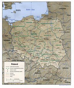
Statistics
- Area - comparative: slightly smaller than New MexicoNew MexicoNew Mexico is a state located in the southwest and western regions of the United States. New Mexico is also usually considered one of the Mountain States. With a population density of 16 per square mile, New Mexico is the sixth-most sparsely inhabited U.S...
. - Land boundaries: total: 2,888 km
- Border countries and length: Belarus: 605 km, Czech Republic: 658 km, Germany: 456 km, Lithuania: 91 km, Russia: (Kaliningrad OblastKaliningrad OblastKaliningrad Oblast is a federal subject of Russia situated on the Baltic coast. It has a population of The oblast forms the westernmost part of the Russian Federation, but it has no land connection to the rest of Russia. Since its creation it has been an exclave of the Russian SFSR and then the...
): 206 km, Slovakia: 444 km, Ukraine: 428 km - Coastline: 491 km
- Maritime claims: exclusive economic zone defined by international treaties
- Territorial sea: 12 nmi (22.2 km; 13.8 mi)
- Elevation extremes: lowest point Raczki ElblaskieRaczki ElblaskieRaczki Elbląskie is a village in the administrative district of Gmina Elbląg, within Elbląg County, Warmian-Masurian Voivodeship, in northern Poland...
-1,8 m; highest point: RysyRysyRysy is a mountain in the crest of the High Tatras, lying on the border between Poland and Slovakia. Rysy has three peaks: the middle at ; the north-western at ; and the south-eastern at...
2,499 m - See islands: WolinWolinWolin is the name both of an island in the Baltic Sea, just off the Polish coast, and a town on that island. It is separated from the island of Usedom by the Świna river, and from mainland Pomerania by the Dziwna river...
, eastern part of UsedomUsedomUsedom is a Baltic Sea island on the border between Germany and Poland. It is situated north of the Szczecin Lagoon estuary of the River Oder in Pomerania...
Resources and land use
- Natural resources: coalCoalCoal is a combustible black or brownish-black sedimentary rock usually occurring in rock strata in layers or veins called coal beds or coal seams. The harder forms, such as anthracite coal, can be regarded as metamorphic rock because of later exposure to elevated temperature and pressure...
, sulfurSulfurSulfur or sulphur is the chemical element with atomic number 16. In the periodic table it is represented by the symbol S. It is an abundant, multivalent non-metal. Under normal conditions, sulfur atoms form cyclic octatomic molecules with chemical formula S8. Elemental sulfur is a bright yellow...
, copperCopperCopper is a chemical element with the symbol Cu and atomic number 29. It is a ductile metal with very high thermal and electrical conductivity. Pure copper is soft and malleable; an exposed surface has a reddish-orange tarnish...
, natural gasNatural gasNatural gas is a naturally occurring gas mixture consisting primarily of methane, typically with 0–20% higher hydrocarbons . It is found associated with other hydrocarbon fuel, in coal beds, as methane clathrates, and is an important fuel source and a major feedstock for fertilizers.Most natural...
, ironIronIron is a chemical element with the symbol Fe and atomic number 26. It is a metal in the first transition series. It is the most common element forming the planet Earth as a whole, forming much of Earth's outer and inner core. It is the fourth most common element in the Earth's crust...
, zincZincZinc , or spelter , is a metallic chemical element; it has the symbol Zn and atomic number 30. It is the first element in group 12 of the periodic table. Zinc is, in some respects, chemically similar to magnesium, because its ion is of similar size and its only common oxidation state is +2...
, leadLeadLead is a main-group element in the carbon group with the symbol Pb and atomic number 82. Lead is a soft, malleable poor metal. It is also counted as one of the heavy metals. Metallic lead has a bluish-white color after being freshly cut, but it soon tarnishes to a dull grayish color when exposed...
, saltSaltIn chemistry, salts are ionic compounds that result from the neutralization reaction of an acid and a base. They are composed of cations and anions so that the product is electrically neutral...
, arable land - Land use: arable landArable landIn geography and agriculture, arable land is land that can be used for growing crops. It includes all land under temporary crops , temporary meadows for mowing or pasture, land under market and kitchen gardens and land temporarily fallow...
: 47%; permanent crops: 15%; permanent pastures 13% - Forests of Poland and woodlandWoodlandEcologically, a woodland is a low-density forest forming open habitats with plenty of sunlight and limited shade. Woodlands may support an understory of shrubs and herbaceous plants including grasses. Woodland may form a transition to shrubland under drier conditions or during early stages of...
s: 29%; other: 10% (1993 est.) - IrrigatedIrrigationIrrigation may be defined as the science of artificial application of water to the land or soil. It is used to assist in the growing of agricultural crops, maintenance of landscapes, and revegetation of disturbed soils in dry areas and during periods of inadequate rainfall...
land: 1,000 km² (1993 est.) - Important rivers: VistulaVistulaThe Vistula is the longest and the most important river in Poland, at 1,047 km in length. The watershed area of the Vistula is , of which lies within Poland ....
(Wisła), Oder (Odra), BugBug RiverThe Bug River is a left tributary of the Narew river flows from central Ukraine to the west, passing along the Ukraine-Polish and Polish-Belarusian border and into Poland, where it empties into the Narew river near Serock. The part between the lake and the Vistula River is sometimes referred to as...
, Warta RiverWarta RiverThe Warta is a river in western-central Poland, a tributary of the Oder river. With a length of approximately it is the country's third longest river. The Warta has a basin area of 54,529 square kilometers...
, NarewNarewThe Narew River , in western Belarus and north-eastern Poland, is a left tributary of the Vistula river...
, SanSan RiverThe San is a river in southeastern Poland and western Ukraine, a tributary of the Vistula River, with a length of 433 km and a basin area of 16,861 km2...
)
Environmental concerns
Natural hazards: occasional floodingNational parks
Environment - current issues:
The situation has improved since 1989 due to decline in heavy industry and
increased environmental concern by postcommunist
Communism
Communism is a social, political and economic ideology that aims at the establishment of a classless, moneyless, revolutionary and stateless socialist society structured upon common ownership of the means of production...
governments; air pollution
Air pollution
Air pollution is the introduction of chemicals, particulate matter, or biological materials that cause harm or discomfort to humans or other living organisms, or cause damage to the natural environment or built environment, into the atmosphere....
nonetheless remains serious because of sulfur dioxide
Sulfur dioxide
Sulfur dioxide is the chemical compound with the formula . It is released by volcanoes and in various industrial processes. Since coal and petroleum often contain sulfur compounds, their combustion generates sulfur dioxide unless the sulfur compounds are removed before burning the fuel...
emissions from
coal-fired power plants
Power station
A power station is an industrial facility for the generation of electric energy....
, and the resulting acid rain
Acid rain
Acid rain is a rain or any other form of precipitation that is unusually acidic, meaning that it possesses elevated levels of hydrogen ions . It can have harmful effects on plants, aquatic animals, and infrastructure. Acid rain is caused by emissions of carbon dioxide, sulfur dioxide and nitrogen...
has caused forest damage; water pollution from industrial and municipal sources is also a problem, as is disposal of hazardous wastes
Environment - international agreements:
party to:
Air Pollution, Antarctic-Environmental Protocol, Antarctic Treaty, Biodiversity, Climate Change, Endangered Species, Environmental Modification, Hazardous Wastes, Law of the Sea, Marine Dumping, Nuclear Test Ban, Ozone Layer Protection, Ship Pollution, Wetlands
signed, but not ratified:
Air Pollution-Nitrogen Oxides, Air Pollution-Persistent Organic Pollutants, Air Pollution-Sulphur 1994, Climate Change-Kyoto Protocol
Geography - note:
historically, an area of conflict because of flat terrain and the lack of natural barriers on the North European Plain
See also
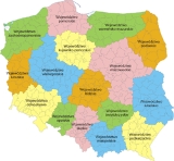
- Administrative division of Poland
- Borders of PolandBorders of PolandThe Borders of Poland are 3511 or 3582 kilometers long. The neighboring countries are Germany to the west, the Czech Republic and Slovakia to the south, Ukraine and Belarus to the east, and Lithuania and the Russian province of Kaliningrad Oblast to the northeast...
- Extreme points of PolandExtreme points of PolandThis is a list of the extreme points of Poland, the points that are farther north, south, east or west than any other location.- Latitude and longitude :* Northernmost point:...
- Tourism in PolandTourism in PolandPoland is a part of the global tourism market with constantly increasing number of visitors, particularly after joining the European Union. Tourism in Poland contributes to the country's overall economy. The most popular cities are Warsaw, Kraków, Wrocław, Gdańsk, Poznań, Lublin, Toruń and the...
- List of caves in Poland
- List of cities in Poland
- List of forests in Poland
- List of islands of Poland
- List of rivers of Poland
- List of mountains in Poland