

Extreme points of Poland
Encyclopedia
Poland
Poland , officially the Republic of Poland , is a country in Central Europe bordered by Germany to the west; the Czech Republic and Slovakia to the south; Ukraine, Belarus and Lithuania to the east; and the Baltic Sea and Kaliningrad Oblast, a Russian exclave, to the north...
, the points that are farther north, south, east or west than any other location.
Latitude and longitude
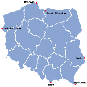
- Northernmost point: 54°50′N 18°04′E
- A beach in Jastrzębia Góra, part of the town WładysławowoWładysławowoWładysławowo is a town on the south coast of the Baltic Sea in the Kashubia in Eastern Pomerania region, northern Poland, with 15,015 inhabitants.-Overview:...
, Pomeranian VoivodeshipPomeranian VoivodeshipPomeranian Voivodeship, or Pomerania Province , is a voivodeship, or province, in north-central Poland. It comprises most of Pomerelia , as well as an area east of the Vistula River...
, marked by the "Northern Star" obelisk, near RozewieRozewieCape Rozewie is a headland on the Baltic coast of Poland, in Pomeranian Voivodeship. It was formerly thought to be the most northerly point in Poland, but since measurements carried out in December 2000, that distinction is now given to a nearby beach in Jastrzębia Góra, marked by the "Northern...
cape on the BalticBaltic SeaThe Baltic Sea is a brackish mediterranean sea located in Northern Europe, from 53°N to 66°N latitude and from 20°E to 26°E longitude. It is bounded by the Scandinavian Peninsula, the mainland of Europe, and the Danish islands. It drains into the Kattegat by way of the Øresund, the Great Belt and...
coast
- A beach in Jastrzębia Góra, part of the town Władysławowo
- Southernmost point: 49°00′N 22°40′E
- Wołosate ridge, near mount Opołonek, Eastern BeskidEastern BeskidsThe Eastern Beskids is a set of mountain ranges spanning the northern Slovakian and southern Polish border....
mountains, Subcarpathian VoivodeshipSubcarpathian VoivodeshipPodkarpackie Voivodeship , or Subcarpathian Voivodeship, is a voivodeship, or province, in extreme-southeastern Poland. Its administrative capital and largest city is Rzeszów...
- Wołosate ridge, near mount Opołonek, Eastern Beskid
- Easternmost point: 50°51′N 24°09′E
- Bug RiverBug RiverThe Bug River is a left tributary of the Narew river flows from central Ukraine to the west, passing along the Ukraine-Polish and Polish-Belarusian border and into Poland, where it empties into the Narew river near Serock. The part between the lake and the Vistula River is sometimes referred to as...
, near Zosin, Hrubieszów CountyZosin, Hrubieszów CountyZosin is a village in the administrative district of Gmina Horodło, within Hrubieszów County, Lublin Voivodeship, in eastern Poland, close to the border with Ukraine. It lies approximately south-east of Horodło, east of Hrubieszów, and east of the regional capital Lublin.The village has a...
, Lublin VoivodeshipLublin Voivodeship- Administrative division :Lublin Voivodeship is divided into 24 counties : 4 city counties and 20 land counties. These are further divided into 213 gminas....
- Bug River
- Westernmost point: 52°50′N 14°07′E
- Oder River, near Osinów DolnyOsinów DolnyOsinów Dolny is Poland's westernmost settlement, in the administrative district of Gmina Cedynia, within Gryfino County, West Pomeranian Voivodeship, in north-western Poland, on the border with Germany...
, West Pomeranian VoivodeshipWest Pomeranian VoivodeshipWest Pomeranian Voivodeship, , is a voivodeship in northwestern Poland. It borders on Pomeranian Voivodeship to the east, Greater Poland Voivodeship to the southeast, Lubusz Voivodeship to the south, the German federal-state of Mecklenburg-West Pomerania to the west, and the Baltic Sea to the north...
- Oder River, near Osinów Dolny
Elevation
- Highest point:
- mount RysyRysyRysy is a mountain in the crest of the High Tatras, lying on the border between Poland and Slovakia. Rysy has three peaks: the middle at ; the north-western at ; and the south-eastern at...
, High TatraHigh TatrasHigh Tatras or High Tatra are a mountain range on the borders between Slovakia and Poland. They are a part of the Tatra Mountains...
mountains, Lesser Poland VoivodeshipLesser Poland VoivodeshipMałopolska Voivodeship , or Lesser Poland Voivodeship, is a voivodeship, in southern Poland...
(2499 m, while its highest peak, 2503 m, is located in SlovakiaSlovakiaThe Slovak Republic is a landlocked state in Central Europe. It has a population of over five million and an area of about . Slovakia is bordered by the Czech Republic and Austria to the west, Poland to the north, Ukraine to the east and Hungary to the south...
)
- mount Rysy
- Lowest point:
- Raczki ElbląskieRaczki ElblaskieRaczki Elbląskie is a village in the administrative district of Gmina Elbląg, within Elbląg County, Warmian-Masurian Voivodeship, in northern Poland...
, in the Vistula LagoonVistula LagoonThe Vistula Lagoon is a fresh water lagoon on the Baltic Sea separated from Gdańsk Bay by the Vistula Spit. It is sometimes known as the Vistula Bay or Vistula Gulf. The modern German name, Frisches Haff, is derived from an earlier form, Friesisches Haff. Both this term and the earlier Polish...
, Pomeranian VoivodeshipPomeranian VoivodeshipPomeranian Voivodeship, or Pomerania Province , is a voivodeship, or province, in north-central Poland. It comprises most of Pomerelia , as well as an area east of the Vistula River...
(-1.8 m)
- Raczki Elbląskie
Central point
A point in the village of Piątek, Łódź Voivodeship is claimed to be the "geometrical centre" (not the exact geographical centreGeographical centre
In geography, the centroid of the two-dimensional shape of region of the Earth's surface is often known as its geographical centre. There has long been debate over the methods of calculation of the geographical centres of various countries and regions, such as whether to include offshore islands,...
) of Poland.
See also
- Geography of PolandGeography of PolandPoland is a country in Central Europe with an area of 312,679 square kilometres , and mostly temperate climate. Generally speaking, Poland is an almost unbroken plain reaching from the Baltic Sea in the north, to the Carpathian Mountains in the south...
- Extreme points of EuropeExtreme points of EuropeThis is a list of the extreme points of Europe: the geographical points that are higher, farther north, south, east or west than any other location in Europe. Some of these positions are open to debate, as the definition of Europe is diverse....
- Extreme points of the European UnionExtreme points of the European UnionThis is a list of the extreme points of the European Union — the points that are farther north, south, east or west than any other location.-In Europe:* North: Nuorgam, Finland...