

Geographical centre of Europe
Encyclopedia
The location of the geographical centre of Europe depends on the definition of the borders of Europe
, mainly whether remote islands are included to define the extreme points of Europe
, and on the method of calculating the final result. Thus, several places claim to host this hypothetical centre.
include:
As noted below, Guinness World Records
recognises Bernotai, 26 km. north of Vilnius
, Lithuania
, as the "official" geographical midpoint of Europe. But that does not preclude other centres, depending on the methodology used in making the determination.
geographers did their own geographic analysis at the beginning of the 1900s and concluded that the Austrian measurements were incorrect. The German scientists stated that the true geographic centre of Europe was in the Saxon
capital city of Dresden
, near the Frauenkirche
.
by Soviet
scientists again proclaimed Rakhiv and Dilove (in Russian: Rakhov and Dyelovoye) to be the geographical centre of Europe. The old marker in the small town was renewed, and a major campaign to convince everyone of its validity was undertaken.
, near the mining town of Kremnica
, now a famous centre for winter sports. There is now a stone commemorating the point at 48°45′N 18°55′E as well as a hotel and a recreation centre called "Centre of Europe".
of Europe
in 1989, Jean-George Affholder, a scientist at the Institut Géographique National
(French National Geographic Institute) determined that the Geographic Centre of Europe is located at 54°54′N 25°19′E. The method used for calculating this point was that of the centre of gravity of the geometrical figure
of Europe.
This point is located in Lithuania
, specifically 26 kilometres (16.2 mi) north of its capital city, Vilnius
, near the village of Purnuškės. A monument, composed by the sculptor Gediminas Jokūbonis and consisting of a column of white granite surmounted by a crown of stars, was erected at the location in 2004. An area of woods and fields surrounding the geographic centre point and including Lake Girija, Bernotai Hill, and an old burial ground, was set aside as a reserve in 1992. The State Tourism Department at the Ministry of Economy of Lithuania has classified the Geographic Centre monument and its reserve as a tourist attraction. This location is the only one listed in the Guinness Book of World Records as the geographical centre of Europe.
17 km away lies Europos Parkas
, Open Air Museum of the Centre of Europe, a sculpture park containing the world's largest sculpture made of TV sets.
, Hungary48.23610°N 21.22574°E. In 2000, a sculpture was erected in the village, with a table on it declaring the place the "Geometric Centre of Europe".
to the Franz Joseph Land and from Crete
to Iceland
, are taken into consideration, it is claimed that the centre of Europe lies on the island of Saaremaa
in western Estonia
, in Mõnnuste village, at 58°18′14"N 22°16′44"E. Again, no author and no method of calculation was disclosed. The local Kärla Parish is looking to verify the location and turn it into a tourist location.
55°11′0"N 30°10′0"E in northeastern Belarus
, or alternatively Babruysk
53°34′01"N 29°23′52"E in the western part of the province of Mahilyow of the eastern Belarus, is the centre of Europe.
In 2000 Belarusian scientists Alexey Solomonov and Valery Anoshko published a report that stated the geographic centre of Europe was located near Lake Sho (55°10′55"N 28°15′30"E; ) in Vitsebsk Voblast
.
Scientists from Russian Central Research Institute of Geodesy, Aerial Survey and Cartography confirmed calculations of Belarusian geodesists that the geographical centre of Europe is located in Polotsk 55°30′0"N 28°48′0"E. A small monument to the Geographical Centre of Europe was set up in Polotsk on May 31, 2008.
ous. Such seems the genesis of the claims that the centre of Europe lies in the following places.
and the states of Georgia
and Azerbaijan
at the Caspian Sea
in the Southeast, Crete
in the South and the Azores
in the Southwest) the centre of Europe will surprisingly be found in Southern Norway
near 60°00′N 07°30′E in the Telemark
region.
If only continental Europe is of interest and outlying islands like Iceland
, Franz Josef Land
and the Azores
are being disregarded, thus having the extreme points in Northern Norway, Gibraltar and again in Crete
and the Caucasus
region, and again based on distances, the centre of Europe would actually be in Poland, somewhere near 53°00′N 16°45′E somewhat North of the city of Poznań
.
(Note: Though further east by longitude than the Caucasus region, the Ural Mountains
can be disregarded as an extreme point because they are actually closer to the centre of Europe.)
(or formerly - European Community).
 As the European Union has been growing the last 50 years, the geographical centre shifted with each expansion.
The calculations of a geographical centre were made by the French Institut Géographique National (IGN) since at least 1987.
, like some Atlantic Ocean
islands, are taken into consideration this point is calculated in different locations. Most of them are located now in Germany
.
is located in France
near the village of Liernais
.
Europe
Europe is, by convention, one of the world's seven continents. Comprising the westernmost peninsula of Eurasia, Europe is generally 'divided' from Asia to its east by the watershed divides of the Ural and Caucasus Mountains, the Ural River, the Caspian and Black Seas, and the waterways connecting...
, mainly whether remote islands are included to define the extreme points of Europe
Extreme points of Europe
This is a list of the extreme points of Europe: the geographical points that are higher, farther north, south, east or west than any other location in Europe. Some of these positions are open to debate, as the definition of Europe is diverse....
, and on the method of calculating the final result. Thus, several places claim to host this hypothetical centre.
Some claimants
Locations currently vying for the distinction of being the centre of EuropeEurope
Europe is, by convention, one of the world's seven continents. Comprising the westernmost peninsula of Eurasia, Europe is generally 'divided' from Asia to its east by the watershed divides of the Ural and Caucasus Mountains, the Ural River, the Caspian and Black Seas, and the waterways connecting...
include:
- the small town of RakhivRakhivRakhiv is a city located in the Zakarpattia Oblast in western Ukraine. It is the administrative center of the Rakhiv Raion .- Demographics :As of 2001, the city population was 15,241 inhabitants which included: * 83.8% Ukrainians...
, or the village of Dilove near Rakhiv, in western UkraineUkraineUkraine is a country in Eastern Europe. It has an area of 603,628 km², making it the second largest contiguous country on the European continent, after Russia...
; - Bernotai, or Purnuškės, near VilniusVilniusVilnius is the capital of Lithuania, and its largest city, with a population of 560,190 as of 2010. It is the seat of the Vilnius city municipality and of the Vilnius district municipality. It is also the capital of Vilnius County...
, in LithuaniaLithuaniaLithuania , officially the Republic of Lithuania is a country in Northern Europe, the biggest of the three Baltic states. It is situated along the southeastern shore of the Baltic Sea, whereby to the west lie Sweden and Denmark...
; - a point on the island of SaaremaaSaaremaaSaaremaa is the largest island in Estonia, measuring 2,673 km². The main island of Saare County, it is located in the Baltic Sea, south of Hiiumaa island, and belongs to the West Estonian Archipelago...
in EstoniaEstoniaEstonia , officially the Republic of Estonia , is a state in the Baltic region of Northern Europe. It is bordered to the north by the Gulf of Finland, to the west by the Baltic Sea, to the south by Latvia , and to the east by Lake Peipsi and the Russian Federation . Across the Baltic Sea lies...
; - the village of KrahuleKrahuleKrahule is a village in Žiar nad Hronom District in the Banská Bystrica Region of central Slovakia. It is the only municipality in Slovakia that officially uses German along with Slovak.-History:...
, near KremnicaKremnicaKremnica is a town in central Slovakia. It has some 5,700 inhabitants. The well-preserved medieval town built above important gold mines is the site of the oldest still-working mint in the world.-History:...
, in central SlovakiaSlovakiaThe Slovak Republic is a landlocked state in Central Europe. It has a population of over five million and an area of about . Slovakia is bordered by the Czech Republic and Austria to the west, Poland to the north, Ukraine to the east and Hungary to the south...
; - SuchowolaSuchowolaSuchowola is a town in north-eastern Poland in Sokółka county, located on both banks of the Olszanka River. Its population is 2,500 ....
, north of Białystok, in northeast PolandPolandPoland , officially the Republic of Poland , is a country in Central Europe bordered by Germany to the west; the Czech Republic and Slovakia to the south; Ukraine, Belarus and Lithuania to the east; and the Baltic Sea and Kaliningrad Oblast, a Russian exclave, to the north...
; and ToruńTorunToruń is an ancient city in northern Poland, on the Vistula River. Its population is more than 205,934 as of June 2009. Toruń is one of the oldest cities in Poland. The medieval old town of Toruń is the birthplace of the astronomer Nicolaus Copernicus....
, in north-central PolandPolandPoland , officially the Republic of Poland , is a country in Central Europe bordered by Germany to the west; the Czech Republic and Slovakia to the south; Ukraine, Belarus and Lithuania to the east; and the Baltic Sea and Kaliningrad Oblast, a Russian exclave, to the north...
; - a point near Polotsk in BelarusBelarusBelarus , officially the Republic of Belarus, is a landlocked country in Eastern Europe, bordered clockwise by Russia to the northeast, Ukraine to the south, Poland to the west, and Lithuania and Latvia to the northwest. Its capital is Minsk; other major cities include Brest, Grodno , Gomel ,...
. - A memorial near TállyaTállyaTállya is a village in Borsod-Abaúj-Zemplén county, Northern Hungary, 45 kilometres from county seat Miskolc, in the famous Tokaj-Hegyalja wine district.-Geography:Tállya is located at . According to the 2001 Census the village has a total area of ....
, HungaryHungaryHungary , officially the Republic of Hungary , is a landlocked country in Central Europe. It is situated in the Carpathian Basin and is bordered by Slovakia to the north, Ukraine and Romania to the east, Serbia and Croatia to the south, Slovenia to the southwest and Austria to the west. The...
As noted below, Guinness World Records
Guinness World Records
Guinness World Records, known until 2000 as The Guinness Book of Records , is a reference book published annually, containing a collection of world records, both human achievements and the extremes of the natural world...
recognises Bernotai, 26 km. north of Vilnius
Vilnius
Vilnius is the capital of Lithuania, and its largest city, with a population of 560,190 as of 2010. It is the seat of the Vilnius city municipality and of the Vilnius district municipality. It is also the capital of Vilnius County...
, Lithuania
Lithuania
Lithuania , officially the Republic of Lithuania is a country in Northern Europe, the biggest of the three Baltic states. It is situated along the southeastern shore of the Baltic Sea, whereby to the west lie Sweden and Denmark...
, as the "official" geographical midpoint of Europe. But that does not preclude other centres, depending on the methodology used in making the determination.
Austria-Hungary
- Modern day Ukraine: In 1887, geographers from the Austro-Hungarian EmpireAustria-HungaryAustria-Hungary , more formally known as the Kingdoms and Lands Represented in the Imperial Council and the Lands of the Holy Hungarian Crown of Saint Stephen, was a constitutional monarchic union between the crowns of the Austrian Empire and the Kingdom of Hungary in...
set up a historical marker and a large stone in what is today a part of UkraineUkraineUkraine is a country in Eastern Europe. It has an area of 603,628 km², making it the second largest contiguous country on the European continent, after Russia...
, believed to mark the geographic centre of Europe. The interpretation of the worn LatinLatinLatin is an Italic language originally spoken in Latium and Ancient Rome. It, along with most European languages, is a descendant of the ancient Proto-Indo-European language. Although it is considered a dead language, a number of scholars and members of the Christian clergy speak it fluently, and...
inscription on the monumentMonumentA monument is a type of structure either explicitly created to commemorate a person or important event or which has become important to a social group as a part of their remembrance of historic times or cultural heritage, or simply as an example of historic architecture...
is debated, with some claiming that the marker is merely one of a number of fixed triangulationTriangulationIn trigonometry and geometry, triangulation is the process of determining the location of a point by measuring angles to it from known points at either end of a fixed baseline, rather than measuring distances to the point directly...
points for surveying purposes established around the territory of the former Empire. The external borders of Europe taken into account during the calculations are not known. According to the description, the methodology used for the calculation is that of the geometrical middle point of the extreme latitudeLatitudeIn geography, the latitude of a location on the Earth is the angular distance of that location south or north of the Equator. The latitude is an angle, and is usually measured in degrees . The equator has a latitude of 0°, the North pole has a latitude of 90° north , and the South pole has a...
s and longitudeLongitudeLongitude is a geographic coordinate that specifies the east-west position of a point on the Earth's surface. It is an angular measurement, usually expressed in degrees, minutes and seconds, and denoted by the Greek letter lambda ....
s of Europe, so the stone was located at 48°30′N 23°23′E. However, the actual location of the monument seems rather 47°57′46.47"N 24°11′14.4"E and not the coordinates to which they relate. The village of Dilove located on the TiszaTiszaThe Tisza or Tisa is one of the main rivers of Central Europe. It rises in Ukraine, and is formed near Rakhiv by the junction of headwaters White Tisa, whose source is in the Chornohora mountains and Black Tisa, which springs in the Gorgany range...
river, close to the RomaniaRomaniaRomania is a country located at the crossroads of Central and Southeastern Europe, on the Lower Danube, within and outside the Carpathian arch, bordering on the Black Sea...
n border, in the county of RakhivRakhivRakhiv is a city located in the Zakarpattia Oblast in western Ukraine. It is the administrative center of the Rakhiv Raion .- Demographics :As of 2001, the city population was 15,241 inhabitants which included: * 83.8% Ukrainians...
in the TranscarpathianCarpathian RutheniaCarpathian Ruthenia is a region in Eastern Europe, mostly located in western Ukraine's Zakarpattia Oblast , with smaller parts in easternmost Slovakia , Poland's Lemkovyna and Romanian Maramureş.It is...
region.
- Modern day Czech Republic/Bavaria: Austrian geographers also marked the 939 metre high Tillenberg (DyleňDyleňDyleň is a mountain in the Karlovy Vary Region of western Bohemia, located roughly from the Czech Republic–Germany border. At above sea level, its summit is the second highest peak in the Upper Palatinate Range ....
) near the BohemiaBohemiaBohemia is a historical region in central Europe, occupying the western two-thirds of the traditional Czech Lands. It is located in the contemporary Czech Republic with its capital in Prague...
n city of Eger/ChebChebCheb is a city in the Karlovy Vary Region of the Czech Republic, with about 33,000 inhabitants. It is situated on the river Ohře , at the foot of one of the spurs of the Smrčiny and near the border with Germany...
with a copper plate as the centre of Europe. As the border to Germany/Bavaria runs 100m west of the mountaintop, the German village of NeualbenreuthNeualbenreuthNeualbenreuth is a municipality in the district of Tirschenreuth in Bavaria, Germany....
uses this for promotional purposes. Bayerischer RundfunkBayerischer RundfunkBayerischer Rundfunk [Bavarian Broadcasting] is the public broadcasting authority for the German Freistaat of Bavaria, with its main offices located in Munich. BR is a member of ARD.- Legal foundation :...
journalists asked the Institut für Geographie of the University of Munich to verify the claims. The institute concluded that the centre lies further to the south, in Hildweinsreuth near FlossenbürgFlossenbürgFlossenbürg is a municipality in the district of Neustadt an der Waldnaab in Bavaria in Germany. The state-approved leisure area is located in the Bavarian Forest and borders the Czech Republic in the east. During World War II, the Flossenbürg concentration camp was located here.- History :The...
.
German measurements
German EmpireGerman Empire
The German Empire refers to Germany during the "Second Reich" period from the unification of Germany and proclamation of Wilhelm I as German Emperor on 18 January 1871, to 1918, when it became a federal republic after defeat in World War I and the abdication of the Emperor, Wilhelm II.The German...
geographers did their own geographic analysis at the beginning of the 1900s and concluded that the Austrian measurements were incorrect. The German scientists stated that the true geographic centre of Europe was in the Saxon
Saxony
The Free State of Saxony is a landlocked state of Germany, contingent with Brandenburg, Saxony Anhalt, Thuringia, Bavaria, the Czech Republic and Poland. It is the tenth-largest German state in area, with of Germany's sixteen states....
capital city of Dresden
Dresden
Dresden is the capital city of the Free State of Saxony in Germany. It is situated in a valley on the River Elbe, near the Czech border. The Dresden conurbation is part of the Saxon Triangle metropolitan area....
, near the Frauenkirche
Dresden Frauenkirche
The Dresden Frauenkirche is a Lutheran church in Dresden, eastern Germany.Built in the 18th century, the church was destroyed in the firebombing of Dresden during World War II. It has been reconstructed as a landmark symbol of reconciliation between former warring enemies...
.
Soviet measurements
Measurements done after World War IIWorld War II
World War II, or the Second World War , was a global conflict lasting from 1939 to 1945, involving most of the world's nations—including all of the great powers—eventually forming two opposing military alliances: the Allies and the Axis...
by Soviet
Soviet Union
The Soviet Union , officially the Union of Soviet Socialist Republics , was a constitutionally socialist state that existed in Eurasia between 1922 and 1991....
scientists again proclaimed Rakhiv and Dilove (in Russian: Rakhov and Dyelovoye) to be the geographical centre of Europe. The old marker in the small town was renewed, and a major campaign to convince everyone of its validity was undertaken.
Slovakia
Another possible centre of Europe is the Central Slovak town of KrahuleKrahule
Krahule is a village in Žiar nad Hronom District in the Banská Bystrica Region of central Slovakia. It is the only municipality in Slovakia that officially uses German along with Slovak.-History:...
, near the mining town of Kremnica
Kremnica
Kremnica is a town in central Slovakia. It has some 5,700 inhabitants. The well-preserved medieval town built above important gold mines is the site of the oldest still-working mint in the world.-History:...
, now a famous centre for winter sports. There is now a stone commemorating the point at 48°45′N 18°55′E as well as a hotel and a recreation centre called "Centre of Europe".
Lithuania
After a re-estimation of the boundaries of the continentContinent
A continent is one of several very large landmasses on Earth. They are generally identified by convention rather than any strict criteria, with seven regions commonly regarded as continents—they are : Asia, Africa, North America, South America, Antarctica, Europe, and Australia.Plate tectonics is...
of Europe
Europe
Europe is, by convention, one of the world's seven continents. Comprising the westernmost peninsula of Eurasia, Europe is generally 'divided' from Asia to its east by the watershed divides of the Ural and Caucasus Mountains, the Ural River, the Caspian and Black Seas, and the waterways connecting...
in 1989, Jean-George Affholder, a scientist at the Institut Géographique National
Institut géographique national (France)
This article is about the French Institut Géographique National; for the similar Belgian institution also called Institut Géographique National see Nationaal Geografisch Instituut - Institut Géographique National...
(French National Geographic Institute) determined that the Geographic Centre of Europe is located at 54°54′N 25°19′E. The method used for calculating this point was that of the centre of gravity of the geometrical figure
Geometry
Geometry arose as the field of knowledge dealing with spatial relationships. Geometry was one of the two fields of pre-modern mathematics, the other being the study of numbers ....
of Europe.
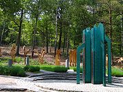
This point is located in Lithuania
Lithuania
Lithuania , officially the Republic of Lithuania is a country in Northern Europe, the biggest of the three Baltic states. It is situated along the southeastern shore of the Baltic Sea, whereby to the west lie Sweden and Denmark...
, specifically 26 kilometres (16.2 mi) north of its capital city, Vilnius
Vilnius
Vilnius is the capital of Lithuania, and its largest city, with a population of 560,190 as of 2010. It is the seat of the Vilnius city municipality and of the Vilnius district municipality. It is also the capital of Vilnius County...
, near the village of Purnuškės. A monument, composed by the sculptor Gediminas Jokūbonis and consisting of a column of white granite surmounted by a crown of stars, was erected at the location in 2004. An area of woods and fields surrounding the geographic centre point and including Lake Girija, Bernotai Hill, and an old burial ground, was set aside as a reserve in 1992. The State Tourism Department at the Ministry of Economy of Lithuania has classified the Geographic Centre monument and its reserve as a tourist attraction. This location is the only one listed in the Guinness Book of World Records as the geographical centre of Europe.
17 km away lies Europos Parkas
Europos Parkas
Europos Parkas is a 50-hectare open-air museum located 17 km from Vilnius, Lithuania. The museum gives an artistic significance to the geographic centre of the European continent and presents Lithuanian and international modern art.-Collection:The museum exhibits more than 90 works from 27...
, Open Air Museum of the Centre of Europe, a sculpture park containing the world's largest sculpture made of TV sets.
Hungary
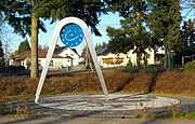
It is claimed that a 1992 survey found that the geometric centre of Europe is in the village of TállyaTállya
Tállya is a village in Borsod-Abaúj-Zemplén county, Northern Hungary, 45 kilometres from county seat Miskolc, in the famous Tokaj-Hegyalja wine district.-Geography:Tállya is located at . According to the 2001 Census the village has a total area of ....
, Hungary48.23610°N 21.22574°E. In 2000, a sculpture was erected in the village, with a table on it declaring the place the "Geometric Centre of Europe".
Estonia
If all the islands of Europe, from AzoresAzores
The Archipelago of the Azores is composed of nine volcanic islands situated in the middle of the North Atlantic Ocean, and is located about west from Lisbon and about east from the east coast of North America. The islands, and their economic exclusion zone, form the Autonomous Region of the...
to the Franz Joseph Land and from Crete
Crete
Crete is the largest and most populous of the Greek islands, the fifth largest island in the Mediterranean Sea, and one of the thirteen administrative regions of Greece. It forms a significant part of the economy and cultural heritage of Greece while retaining its own local cultural traits...
to Iceland
Iceland
Iceland , described as the Republic of Iceland, is a Nordic and European island country in the North Atlantic Ocean, on the Mid-Atlantic Ridge. Iceland also refers to the main island of the country, which contains almost all the population and almost all the land area. The country has a population...
, are taken into consideration, it is claimed that the centre of Europe lies on the island of Saaremaa
Saaremaa
Saaremaa is the largest island in Estonia, measuring 2,673 km². The main island of Saare County, it is located in the Baltic Sea, south of Hiiumaa island, and belongs to the West Estonian Archipelago...
in western Estonia
Estonia
Estonia , officially the Republic of Estonia , is a state in the Baltic region of Northern Europe. It is bordered to the north by the Gulf of Finland, to the west by the Baltic Sea, to the south by Latvia , and to the east by Lake Peipsi and the Russian Federation . Across the Baltic Sea lies...
, in Mõnnuste village, at 58°18′14"N 22°16′44"E. Again, no author and no method of calculation was disclosed. The local Kärla Parish is looking to verify the location and turn it into a tourist location.
Belarus
Recently a new claim has been made that VitebskVitebsk
Vitebsk, also known as Viciebsk or Vitsyebsk , is a city in Belarus, near the border with Russia. The capital of the Vitebsk Oblast, in 2004 it had 342,381 inhabitants, making it the country's fourth largest city...
55°11′0"N 30°10′0"E in northeastern Belarus
Belarus
Belarus , officially the Republic of Belarus, is a landlocked country in Eastern Europe, bordered clockwise by Russia to the northeast, Ukraine to the south, Poland to the west, and Lithuania and Latvia to the northwest. Its capital is Minsk; other major cities include Brest, Grodno , Gomel ,...
, or alternatively Babruysk
Babruysk
Babruysk or Bobruysk is a city in the Mahilyow Voblast of Belarus on the Berezina river. It is a large city in Belarus with a population of approximately 227,000 people . The name Babruysk probably originates from the Belarusian word babyor , many of which used to inhabit the Berezina...
53°34′01"N 29°23′52"E in the western part of the province of Mahilyow of the eastern Belarus, is the centre of Europe.
In 2000 Belarusian scientists Alexey Solomonov and Valery Anoshko published a report that stated the geographic centre of Europe was located near Lake Sho (55°10′55"N 28°15′30"E; ) in Vitsebsk Voblast
Vitsebsk Voblast
Vitsebsk Voblast or Vitebsk Oblast is a province of Belarus with its administrative center being Vitebsk .As of a 2009 estimate, the voblast has a population of 1,230,800...
.
Scientists from Russian Central Research Institute of Geodesy, Aerial Survey and Cartography confirmed calculations of Belarusian geodesists that the geographical centre of Europe is located in Polotsk 55°30′0"N 28°48′0"E. A small monument to the Geographical Centre of Europe was set up in Polotsk on May 31, 2008.
Possibly mistaken claims
Certain people mistakenly take two notions: "geographical centre of Europe" and "geographical centre of a country lying (approximately) in the centre of Europe" to be synonymSynonym
Synonyms are different words with almost identical or similar meanings. Words that are synonyms are said to be synonymous, and the state of being a synonym is called synonymy. The word comes from Ancient Greek syn and onoma . The words car and automobile are synonyms...
ous. Such seems the genesis of the claims that the centre of Europe lies in the following places.
- ČíhošťČíhošťČíhošť is a village and municipality in Havlíčkův Brod District in the Vysočina Region of the Czech Republic.The municipality covers an area of , and has a population of 336 ....
near Ledeč nad SázavouLedec nad SázavouLedeč nad Sázavou is a town in the Vysočina Region, Czech Republic. It is located at around . The Sázava River flows through the town.- External links :* *...
, Czech RepublicCzech RepublicThe Czech Republic is a landlocked country in Central Europe. The country is bordered by Poland to the northeast, Slovakia to the east, Austria to the south, and Germany to the west and northwest....
- place of the geometrical centre of the Czech Republic. Although the Czech Republic considers itself a "country in the heart of Europe", this point does not claim to be a centre of the whole Europe. - PiątekPiatekThe Piatek exists in Armenian folklore as a large mammal from very ancient times. This animal had a very large beak and strange hair which stood on end. This is all that remains today of any description of such a creature, as it can be found only in one Armenian tablet...
in the centre of Poland. - Braunau am InnBraunau am InnBraunau am Inn is a town in the Innviertel region of Upper Austria , the north-western state of Austria. It lies about 90 km west of Linz and about 60 km north of Salzburg, on the border with the German state of Bavaria. The population in 2001 was 16,372...
in AustriaAustriaAustria , officially the Republic of Austria , is a landlocked country of roughly 8.4 million people in Central Europe. It is bordered by the Czech Republic and Germany to the north, Slovakia and Hungary to the east, Slovenia and Italy to the south, and Switzerland and Liechtenstein to the...
, in the province of Upper AustriaUpper AustriaUpper Austria is one of the nine states or Bundesländer of Austria. Its capital is Linz. Upper Austria borders on Germany and the Czech Republic, as well as on the other Austrian states of Lower Austria, Styria, and Salzburg...
(Oberösterreich), on the border with Germany - was declared the centre of Europe supposedly by Napoleon Bonaparte himself—certainly not for purely geographical but for political reasons.
Other calculations
Based on distance calculations to the extreme points of Europe (Franz Josef Land in the Northeast, the border between the Russian FederationRussia
Russia or , officially known as both Russia and the Russian Federation , is a country in northern Eurasia. It is a federal semi-presidential republic, comprising 83 federal subjects...
and the states of Georgia
Georgia (country)
Georgia is a sovereign state in the Caucasus region of Eurasia. Located at the crossroads of Western Asia and Eastern Europe, it is bounded to the west by the Black Sea, to the north by Russia, to the southwest by Turkey, to the south by Armenia, and to the southeast by Azerbaijan. The capital of...
and Azerbaijan
Azerbaijan
Azerbaijan , officially the Republic of Azerbaijan is the largest country in the Caucasus region of Eurasia. Located at the crossroads of Western Asia and Eastern Europe, it is bounded by the Caspian Sea to the east, Russia to the north, Georgia to the northwest, Armenia to the west, and Iran to...
at the Caspian Sea
Caspian Sea
The Caspian Sea is the largest enclosed body of water on Earth by area, variously classed as the world's largest lake or a full-fledged sea. The sea has a surface area of and a volume of...
in the Southeast, Crete
Crete
Crete is the largest and most populous of the Greek islands, the fifth largest island in the Mediterranean Sea, and one of the thirteen administrative regions of Greece. It forms a significant part of the economy and cultural heritage of Greece while retaining its own local cultural traits...
in the South and the Azores
Azores
The Archipelago of the Azores is composed of nine volcanic islands situated in the middle of the North Atlantic Ocean, and is located about west from Lisbon and about east from the east coast of North America. The islands, and their economic exclusion zone, form the Autonomous Region of the...
in the Southwest) the centre of Europe will surprisingly be found in Southern Norway
Norway
Norway , officially the Kingdom of Norway, is a Nordic unitary constitutional monarchy whose territory comprises the western portion of the Scandinavian Peninsula, Jan Mayen, and the Arctic archipelago of Svalbard and Bouvet Island. Norway has a total area of and a population of about 4.9 million...
near 60°00′N 07°30′E in the Telemark
Telemark
is a county in Norway, bordering Vestfold, Buskerud, Hordaland, Rogaland and Aust-Agder. The county administration is in Skien. Until 1919 the county was known as Bratsberg amt.-Location:...
region.
If only continental Europe is of interest and outlying islands like Iceland
Iceland
Iceland , described as the Republic of Iceland, is a Nordic and European island country in the North Atlantic Ocean, on the Mid-Atlantic Ridge. Iceland also refers to the main island of the country, which contains almost all the population and almost all the land area. The country has a population...
, Franz Josef Land
Franz Josef Land
Franz Josef Land, Franz Joseph Land, or Francis Joseph's Land is an archipelago located in the far north of Russia. It is found in the Arctic Ocean north of Novaya Zemlya and east of Svalbard, and is administered by Arkhangelsk Oblast. Franz Josef Land consists of 191 ice-covered islands with a...
and the Azores
Azores
The Archipelago of the Azores is composed of nine volcanic islands situated in the middle of the North Atlantic Ocean, and is located about west from Lisbon and about east from the east coast of North America. The islands, and their economic exclusion zone, form the Autonomous Region of the...
are being disregarded, thus having the extreme points in Northern Norway, Gibraltar and again in Crete
Crete
Crete is the largest and most populous of the Greek islands, the fifth largest island in the Mediterranean Sea, and one of the thirteen administrative regions of Greece. It forms a significant part of the economy and cultural heritage of Greece while retaining its own local cultural traits...
and the Caucasus
Caucasus
The Caucasus, also Caucas or Caucasia , is a geopolitical region at the border of Europe and Asia, and situated between the Black and the Caspian sea...
region, and again based on distances, the centre of Europe would actually be in Poland, somewhere near 53°00′N 16°45′E somewhat North of the city of Poznań
Poznan
Poznań is a city on the Warta river in west-central Poland, with a population of 556,022 in June 2009. It is among the oldest cities in Poland, and was one of the most important centres in the early Polish state, whose first rulers were buried at Poznań's cathedral. It is sometimes claimed to be...
.
(Note: Though further east by longitude than the Caucasus region, the Ural Mountains
Ural Mountains
The Ural Mountains , or simply the Urals, are a mountain range that runs approximately from north to south through western Russia, from the coast of the Arctic Ocean to the Ural River and northwestern Kazakhstan. Their eastern side is usually considered the natural boundary between Europe and Asia...
can be disregarded as an extreme point because they are actually closer to the centre of Europe.)
Geographic centre of the European Union
Other locations have claimed the title of geographic centre of Europe on the basis of calculations taking into account only the territory of those states which are members of the European UnionEuropean Union
The European Union is an economic and political union of 27 independent member states which are located primarily in Europe. The EU traces its origins from the European Coal and Steel Community and the European Economic Community , formed by six countries in 1958...
(or formerly - European Community).
IGN calculations
The calculations of a geographical centre were made by the French Institut Géographique National (IGN) since at least 1987.
- 12 members: In 1987 the centre of the European Community of the 12 members was declared to be in the middle of FranceFranceThe French Republic , The French Republic , The French Republic , (commonly known as France , is a unitary semi-presidential republic in Western Europe with several overseas territories and islands located on other continents and in the Indian, Pacific, and Atlantic oceans. Metropolitan France...
, in the village of Saint-André-le-CoqSaint-André-le-CoqSaint-André-le-Coq is a commune in the Puy-de-Dôme department in Auvergne in central France.-References:*...
(63310), département of Puy-de-DômePuy-de-DômePuy-de-Dôme is a department in the centre of France named after the famous dormant volcano, the Puy-de-Dôme.Inhabitants were called Puydedomois until December 2005...
(63), régionRegionRegion is most commonly found as a term used in terrestrial and astrophysics sciences also an area, notably among the different sub-disciplines of geography, studied by regional geographers. Regions consist of subregions that contain clusters of like areas that are distinctive by their uniformity...
of AuvergneAuvergne (région)Auvergne is one of the 27 administrative regions of France. It comprises the 4 departments of Allier, Puy de Dome, Cantal and Haute Loire.The current administrative region of Auvergne is larger than the historical province of Auvergne, and includes provinces and areas that historically were not...
, and next was shifted after the reunification of GermanyGermanyGermany , officially the Federal Republic of Germany , is a federal parliamentary republic in Europe. The country consists of 16 states while the capital and largest city is Berlin. Germany covers an area of 357,021 km2 and has a largely temperate seasonal climate...
in 1990 some 25 km north-eastward, to the place called Noireterre in the village of Saint-ClémentSaint-Clément-France:Saint-Clément is the name or part of the name of several communes in France:* Saint-Clément, in the Aisne department* Saint-Clément, in the Allier department* Saint-Clément, in the Ardèche department...
(03250), département of AllierAllierAllier is a department in central France named after the river Allier.- History :Allier is one of the original 83 departments created during the French Revolution on 4 March 1790. It was created from parts of the former provinces of Auvergne and Bourbonnais.In 1940, the government of Marshal...
(03), the same région of Auvergne. A small monument commemorating the latter discovery still exists in Saint Clément. - 15 members: Using the same techniques, the IGN has identified the geographic centre of the 15-member Union (1995–2004) to be in ViroinvalViroinvalViroinval is a Walloon municipality located in Belgium in the province of Namur. On January 1, 2006 Viroinval had a total population of 5,680. The total area is 120.90 km² which gives a population density of 47 inhabitants per km².-Villages in Viroinval:...
, BelgiumBelgiumBelgium , officially the Kingdom of Belgium, is a federal state in Western Europe. It is a founding member of the European Union and hosts the EU's headquarters, and those of several other major international organisations such as NATO.Belgium is also a member of, or affiliated to, many...
, at coordinates 50°00′33"N 4°39′59"E, and a monument there records that finding. - 25 members: The 25-member Union (2004–2007), has a centre calculated by the IGN to be situated at 50°31′31"N 7°35′50"E, in the village of KleinmaischeidKleinmaischeidKleinmaischeid is a municipality in the district of Neuwied, in Rhineland-Palatinate, Germany and was the centre point of the European Union from 1 May 2004 until 31 December 2006....
, Rhineland-PalatinateRhineland-PalatinateRhineland-Palatinate is one of the 16 states of the Federal Republic of Germany. It has an area of and about four million inhabitants. The capital is Mainz. English speakers also commonly refer to the state by its German name, Rheinland-Pfalz ....
, GermanyGermanyGermany , officially the Federal Republic of Germany , is a federal parliamentary republic in Europe. The country consists of 16 states while the capital and largest city is Berlin. Germany covers an area of 357,021 km2 and has a largely temperate seasonal climate...
. - 27 members: On January 1, 2007, with the inclusion of RomaniaRomaniaRomania is a country located at the crossroads of Central and Southeastern Europe, on the Lower Danube, within and outside the Carpathian arch, bordering on the Black Sea...
and BulgariaBulgariaBulgaria , officially the Republic of Bulgaria , is a parliamentary democracy within a unitary constitutional republic in Southeast Europe. The country borders Romania to the north, Serbia and Macedonia to the west, Greece and Turkey to the south, as well as the Black Sea to the east...
in the European Union, the geographic centre of the European Union changed, to a wheat field outside of the German town GelnhausenGelnhausenGelnhausen is a town and the capital of the Main-Kinzig-Kreis, in Hesse, Germany. It is located approx. 40 kilometers east of Frankfurt am Main, between the Vogelsberg mountains and the Spessart range at the river Kinzig...
, in HesseHesseHesse or Hessia is both a cultural region of Germany and the name of an individual German state.* The cultural region of Hesse includes both the State of Hesse and the area known as Rhenish Hesse in the neighbouring Rhineland-Palatinate state...
, 115 km east of the previous marker, at 50°10′21"N 9°9′0"E.
Other calculations
The geographical point of the European Union is not free from disputes, either. If some different extreme points of the European UnionExtreme points of the European Union
This is a list of the extreme points of the European Union — the points that are farther north, south, east or west than any other location.-In Europe:* North: Nuorgam, Finland...
, like some Atlantic Ocean
Atlantic Ocean
The Atlantic Ocean is the second-largest of the world's oceanic divisions. With a total area of about , it covers approximately 20% of the Earth's surface and about 26% of its water surface area...
islands, are taken into consideration this point is calculated in different locations. Most of them are located now in Germany
Germany
Germany , officially the Federal Republic of Germany , is a federal parliamentary republic in Europe. The country consists of 16 states while the capital and largest city is Berlin. Germany covers an area of 357,021 km2 and has a largely temperate seasonal climate...
.
Eurozone
The centre of the EurozoneEurozone
The eurozone , officially called the euro area, is an economic and monetary union of seventeen European Union member states that have adopted the euro as their common currency and sole legal tender...
is located in France
France
The French Republic , The French Republic , The French Republic , (commonly known as France , is a unitary semi-presidential republic in Western Europe with several overseas territories and islands located on other continents and in the Indian, Pacific, and Atlantic oceans. Metropolitan France...
near the village of Liernais
Liernais
Liernais is a commune in the Côte-d'Or department in eastern France.-Population:-See also:*Communes of the Côte-d'Or department*Mancini family*Parc naturel régional du Morvan-References:*...
.
See also
- Central EuropeCentral EuropeCentral Europe or alternatively Middle Europe is a region of the European continent lying between the variously defined areas of Eastern and Western Europe...
- CentroidCentroidIn geometry, the centroid, geometric center, or barycenter of a plane figure or two-dimensional shape X is the intersection of all straight lines that divide X into two parts of equal moment about the line. Informally, it is the "average" of all points of X...
- Geography of EuropeGeography of EuropeEurope is traditionally reckoned as one of seven continents. Physiographically, however, it is the northwestern peninsula of the larger landmass known as Eurasia : Asia occupies the eastern bulk of this continuous landmass and all share a common continental shelf...
- Extreme points of the European UnionExtreme points of the European UnionThis is a list of the extreme points of the European Union — the points that are farther north, south, east or west than any other location.-In Europe:* North: Nuorgam, Finland...