
Floods in the United States: 2001-present
Encyclopedia
Floods in the United States: since 2001 is a list of significant floods which have struck the United States since 2001. Floods are generally caused by excessive rainfall, excessive snowmelt, storm surge
from hurricanes, and dam failure. Below is a list of flood
events which were of significant impact to the country, since 2001.
sat and spun over eastern Texas for several days before moving eastward just inland of the Gulf coast
. Heavy rains fell along the western Gulf coast that week, with storm totals of near 940 mm (37 in) near Houston
and 1041mm (41 in) west of Beaumont
. Damage from the storm was estimated near US$6 billion (2001 dollars), and 41 perished from the flood
.
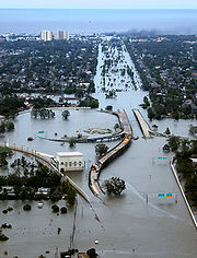 A large category 3 hurricane at landfall along the southeast tip of Louisiana, strong northerly flow behind Katrina while weakening to category 1 strength caused breaks and failures in the levees that protected the lower Ninth Ward
and along other canals in New Orleans, flooding 80 percent of the city for nearly a month. The mouth of the Mississippi River
saw breaks in its levee system due to storm surge. In Mississippi
, a massive storm surge destroyed most structures along the coast including floating casino
s, and preliminary figures show that the storm surge was higher than in Hurricane Camille
of 1969. There were 1,836 fatalities, mostly from flooding.
, as well as an additional tropical disturbance which rode up a stationary frontal zone, set up excessive rains from coastal sections of the Mid-Atlantic states through southern New England. In New Hampshire
, the Monadnock region
was affected, with Alstead
among the hardest hit as 300 mm (12 in) of rain fell within 30 hours, allowing this month to be the wettest in the history of the Granite State. It was considered a once in 500 year flood event.
Prolonged rains fell across Hawaii between February 19 and April 2, 2006 as upper cyclones kept closing off northwest of the archipelago
, virtually eliminating their normal trade winds, and bringing some of the wettest conditions seen for the 50th state since March 1951. Four of the cyclones were kona lows. The heavy rain event of March 1 to March 3 brought severe flooding to the east-facing slopes of the Koolau Range
in Oahu
, with 571 mm (22.47 in) falling in two days at Punalu'u
. During the next rain event from March 8 to March 11, many of the larger islands received significant rain. Flash flooding occurred in Maakua Stream, and severe inundation affected communities from Laie to Kahana. As much as 356 mm (14 in) of rain fell over north Kauai
, forcing the closure of Kuhio Highway at the Hanalei Bridge for the second time in 24-hours. 150–255 mm (6–10 in)of rain fell upon the southeast-facing slopes of the Big Island
causing numerous road closures in Hilo. North and east Kauai experiences 200–300 mm (8–12 in) of rain over a 3 day period. Mount Waialeale
recorded over 711 mm (28 in) during this 4-day period. The Kauai Marriott Resort suffered significant damage due to the overflow of Keonaawanui Stream during the early morning hours of March 11. The third significant rain event between March 13 and March 18 were too much for Ka Loko Dam in northeast Kauai, which failed during the early morning of March 14. The wall of water swept away homes and structures and resulted in 3 confirmed deaths and 4 persons missing. Repeated thunderstorms and heavy rains produced numerous road closures from flooding and inundated many properties.
and Pennsylvania
during late June. Rainfall amounts ranged up to 430 mm (17 in) during the several days of heavy rain. There was threat of dam failure around an earthen dam around Lake Needwood
in eastern Montgomery County, Maryland
, due to the deluge.
 A trio of heavy rainfall events, on October 14–17, October 18–19, and again from October 26–27 set the stage for moderate to significant flooding across portions of eastern Texas, Louisiana
, as well as portions of Arkansas
and Mississippi
. This was the wettest spell for the region since T.S. Allison
of the 1989 Atlantic hurricane season
. Two of these events were fed by tropical cyclones from the 2006 Pacific Hurricane Season
, Norman and Paul, which affected western Mexico. Each rainfall event led to localized maxima in excess of 250 mm (10 in), and helped break a dry spell across the region. Localized totals ranged up to 711 mm (28 in) near Kountze, Texas
during the 13 day period from October 14 through October 27.
and damaged several mountain towns, including North Bend
.
stretching from Iowa
to Ohio
was the focus for several rounds of heavy rainfall resulting in flash flooding the week August 18 – August 25, 2007. Minnesota
, Iowa, Wisconsin
, Illinois
, Indiana
and Ohio were the states hardest hit. Across the six states, 18 counties were declared federal disaster areas. Numerous rainfall records, both for most rain in the month of August as well as 24 hour rainfall totals were recorded. Over 457 mm (18 in) of rain was recorded in some locations during this week. At least $100 million in damages has been reported in Minnesota and Wisconsin alone, and 18 people were killed.
was both closed and damaged.
, White
, Zumbro
, Kickapoo
, Wisconsin
, Baraboo
, Cedar
, Crawfish
, Fox, Iowa
, Rock
, and Des Moines
rivers, as well as the upper Mississippi River
, leading to extensive flooding in Iowa
, Wisconsin
, Indiana
, Minnesota
, Michigan
, and Missouri
.
A major rain event from September 16–22 which brought over ten inches of rain to
the Atlanta, Birmingham, Chattanooga, Athens areas as well as the states of Alabama, Georgia, Tennessee and North Carolina. As of September 22, 2009 in Atlanta, 9 people have been killed due to the floods.
, Blackstone River
and numerous other rivers, lakes, ponds and streams in Rhode Island
. The flooding was the worst in Rhode Island history, as the Pawtuxet River crested over 20 feet—12 feet above flood stage, shattering the previous record by several feet. The rainstorm, which occurred during the cool, dry season, added 8.79" to an already rainy March. At 16.34" of rain, it was the wettest month on record for Rhode Island. A seasonal high tide led to severe coastal flooding in Bristol, Rhode Island
; four of Rhode Island's counties were declared emergency disaster zones. The Warwick Mall
in Warwick was flooded with 20 inches of water, leaving hundreds of employees out of work. A sewage treatment plant in the area failed, contaminating the rainwater with raw sewage. Hundreds of homes in Warwick, Cranston and Johnston were flooded with over a foot of contaminated water. Many towns in Southeastern Massachusetts were also effected by the flood.
Tennessee
, West Tennessee
, south-central and western Kentucky
and northern Mississippi
as the result of torrential rains on May 1 and 2, 2010. Floods from these rains affected the area for several days afterwards, resulting in a number of deaths and widespread property damage.
in New Ulm
, Mankato, St Peter, Jordan
, Shakopee, Savage
, and breaking records in Henderson
. Records were also broken on the Cannon River and the Zumbro River
.
s along the Mississippi River
, flooding some 200 square miles (518 km²) of Missouri
farmland in an effort to save the town of Cairo, Illinois
from record-breaking flood waters. Further downriver in Memphis, Tennessee
the high-end neighborhood of Harbor Town located along the river on Mud Island in Downtown Memphis has begun evacuating its 5,200 residents as flood waters rise to record-levels. Interstate 40
that connects Memphis to Little Rock, Arkansas
has experienced flooding along the White River
where westbound lanes have been closed. Authorities expect the entire highway to be flooded, thus cutting off a major east-west route across the country. In Tunica County, Mississippi
, nine casinos are located in front of the levees in accordance with Mississippi
law restricting gambling to water-born vessels. The hotel portion of the casinos are located on adjacent, low-lying land and have begun to flood with the rising waters. The Harrah's Casino in Tunica has reported nearly six feet of water on the ground floor of the hotel tower.
associated with Lee stalled over the Northeastern states. This drew tropical moisture into the Mid-Atlantic. Over 1 1/2 feet of rain fell in some areas from September 3 to September 7. Moisture from Hurricane Irene had already saturated the ground little over a week before, leaving the runoff plunging straight into waterways. Streams and creaks throughout the region flooded, as well as moderate flooding of the Delaware River
in some spots.
The worst of the flooding stayed in the Susquehanna River
area. Both the West Branch and North Branch, as well as most of their tributaries, flooded. Flood damage was sustained in a swath from southern New York
to the mouth, located at Havre De Grace in northern Maryland
. Record flooding occurred in northeastern and central Pennsylvania
. In Wilkes-Barre, the water was measured at 42.66 feet, an astounding number compared to the record of 40.90 feet Hurricane Agnes
set in 1972. Municipalities along the river sustained major damage, many househoulds and businesses among them declared condemned. The town of Bloomsburg sustained record flood levels, not seen since the flood of 1914 inundated the area. Many homes along U.S. Route 11
had sunken into their foundations, others being stucturely unsound. The Bloomsburg Fair, an event in the town since 1855, was canceled for the first time.
Damages for the disaster will be in the tens of millions (USD), if not hundreds.
Storm surge
A storm surge is an offshore rise of water associated with a low pressure weather system, typically tropical cyclones and strong extratropical cyclones. Storm surges are caused primarily by high winds pushing on the ocean's surface. The wind causes the water to pile up higher than the ordinary sea...
from hurricanes, and dam failure. Below is a list of flood
Flood
A flood is an overflow of an expanse of water that submerges land. The EU Floods directive defines a flood as a temporary covering by water of land not normally covered by water...
events which were of significant impact to the country, since 2001.
Decade of the 2000s
Tropical Storm Allison floods in Louisiana and Texas - June 2001
The remains of the tropical cycloneTropical cyclone
A tropical cyclone is a storm system characterized by a large low-pressure center and numerous thunderstorms that produce strong winds and heavy rain. Tropical cyclones strengthen when water evaporated from the ocean is released as the saturated air rises, resulting in condensation of water vapor...
sat and spun over eastern Texas for several days before moving eastward just inland of the Gulf coast
Gulf of Mexico
The Gulf of Mexico is a partially landlocked ocean basin largely surrounded by the North American continent and the island of Cuba. It is bounded on the northeast, north and northwest by the Gulf Coast of the United States, on the southwest and south by Mexico, and on the southeast by Cuba. In...
. Heavy rains fell along the western Gulf coast that week, with storm totals of near 940 mm (37 in) near Houston
Houston, Texas
Houston is the fourth-largest city in the United States, and the largest city in the state of Texas. According to the 2010 U.S. Census, the city had a population of 2.1 million people within an area of . Houston is the seat of Harris County and the economic center of , which is the ...
and 1041mm (41 in) west of Beaumont
Beaumont, Texas
Beaumont is a city in and county seat of Jefferson County, Texas, United States, within the Beaumont–Port Arthur Metropolitan Statistical Area. The city's population was 118,296 at the 2010 census. With Port Arthur and Orange, it forms the Golden Triangle, a major industrial area on the...
. Damage from the storm was estimated near US$6 billion (2001 dollars), and 41 perished from the flood
Flood
A flood is an overflow of an expanse of water that submerges land. The EU Floods directive defines a flood as a temporary covering by water of land not normally covered by water...
.
Hurricane Katrina (2005) storm surge - Louisiana and Mississippi
Ninth Ward of New Orleans
The Ninth Ward or 9th Ward is a distinctive region of New Orleans, Louisiana that is located in the easternmost downriver portion of the city. It is geographically the largest of the 17 Wards of New Orleans....
and along other canals in New Orleans, flooding 80 percent of the city for nearly a month. The mouth of the Mississippi River
Mississippi River
The Mississippi River is the largest river system in North America. Flowing entirely in the United States, this river rises in western Minnesota and meanders slowly southwards for to the Mississippi River Delta at the Gulf of Mexico. With its many tributaries, the Mississippi's watershed drains...
saw breaks in its levee system due to storm surge. In Mississippi
Mississippi
Mississippi is a U.S. state located in the Southern United States. Jackson is the state capital and largest city. The name of the state derives from the Mississippi River, which flows along its western boundary, whose name comes from the Ojibwe word misi-ziibi...
, a massive storm surge destroyed most structures along the coast including floating casino
Casino
In modern English, a casino is a facility which houses and accommodates certain types of gambling activities. Casinos are most commonly built near or combined with hotels, restaurants, retail shopping, cruise ships or other tourist attractions...
s, and preliminary figures show that the storm surge was higher than in Hurricane Camille
Hurricane Camille
Hurricane Camille was the third and strongest tropical cyclone and second hurricane during the 1969 Atlantic hurricane season. The second of three catastrophic Category 5 hurricanes to make landfall in the United States during the 20th century , which it did near the mouth of the Mississippi River...
of 1969. There were 1,836 fatalities, mostly from flooding.
Mid-Atlantic and New England Flood - October 2005
The combination of a moisture fetch set up by Subtropical Depression 22 and Tropical Storm TammyTropical Storm Tammy (2005)
Tropical Storm Tammy was a short lived tropical storm during October in the 2005 Atlantic hurricane season which caused minor damage to the southeastern United States. More significant, however were its remnants which contributed to the Northeast U.S. flooding of October 2005.Tropical Storm Tammy...
, as well as an additional tropical disturbance which rode up a stationary frontal zone, set up excessive rains from coastal sections of the Mid-Atlantic states through southern New England. In New Hampshire
New Hampshire
New Hampshire is a state in the New England region of the northeastern United States of America. The state was named after the southern English county of Hampshire. It is bordered by Massachusetts to the south, Vermont to the west, Maine and the Atlantic Ocean to the east, and the Canadian...
, the Monadnock region
Monadnock Region
The Monadnock Region is a tourism region in southwestern New Hampshire. It is named after Mount Monadnock, the major geographic landmark in the region. The Monadnock Region is composed of all of Cheshire County and western Hillsborough County. The largest city in the region is Keene...
was affected, with Alstead
Alstead, New Hampshire
Alstead is a town in Cheshire County, New Hampshire, United States. The population was 1,937 at the 2010 census. Alstead is home to Feuer State Forest.-History:...
among the hardest hit as 300 mm (12 in) of rain fell within 30 hours, allowing this month to be the wettest in the history of the Granite State. It was considered a once in 500 year flood event.
Ka Loko Reservoir - March 2006
Prolonged rains fell across Hawaii between February 19 and April 2, 2006 as upper cyclones kept closing off northwest of the archipelago
Archipelago
An archipelago , sometimes called an island group, is a chain or cluster of islands. The word archipelago is derived from the Greek ἄρχι- – arkhi- and πέλαγος – pélagos through the Italian arcipelago...
, virtually eliminating their normal trade winds, and bringing some of the wettest conditions seen for the 50th state since March 1951. Four of the cyclones were kona lows. The heavy rain event of March 1 to March 3 brought severe flooding to the east-facing slopes of the Koolau Range
Koolau Range
Koolau Range is a name given to the fragmented remnant of the eastern or windward shield volcano of the Hawaiian island of Oahu. It is not a mountain range in the normal sense, because it was formed as a single mountain called Koolau Volcano...
in Oahu
Oahu
Oahu or Oahu , known as "The Gathering Place", is the third largest of the Hawaiian Islands and most populous of the islands in the U.S. state of Hawaii. The state capital Honolulu is located on the southeast coast...
, with 571 mm (22.47 in) falling in two days at Punalu'u
Punalu'u, Hawai'i
Punaluu is a census-designated place and rural community in the Koolauloa District on the Island of Oahu, City & County of Honolulu, Hawaii, USA. In Hawaiian, punaluu means "coral dived for", or in the case of the fishpond once located here, possibly "spring dived for"...
. During the next rain event from March 8 to March 11, many of the larger islands received significant rain. Flash flooding occurred in Maakua Stream, and severe inundation affected communities from Laie to Kahana. As much as 356 mm (14 in) of rain fell over north Kauai
Kauai
Kauai or Kauai, known as Tauai in the ancient Kaua'i dialect, is geologically the oldest of the main Hawaiian Islands. With an area of , it is the fourth largest of the main islands in the Hawaiian archipelago, and the 21st largest island in the United States. Known also as the "Garden Isle",...
, forcing the closure of Kuhio Highway at the Hanalei Bridge for the second time in 24-hours. 150–255 mm (6–10 in)of rain fell upon the southeast-facing slopes of the Big Island
Hawaii (island)
The Island of Hawaii, also called the Big Island or Hawaii Island , is a volcanic island in the North Pacific Ocean...
causing numerous road closures in Hilo. North and east Kauai experiences 200–300 mm (8–12 in) of rain over a 3 day period. Mount Waialeale
Mount Waialeale
Mount Waialeale at an elevation of , is a shield volcano and the second highest point on the island of Kauai in the Hawaiian Islands. Averaging more than of rain a year since 1912, with a record in 1982, its summit is one of the rainiest spots on earth....
recorded over 711 mm (28 in) during this 4-day period. The Kauai Marriott Resort suffered significant damage due to the overflow of Keonaawanui Stream during the early morning hours of March 11. The third significant rain event between March 13 and March 18 were too much for Ka Loko Dam in northeast Kauai, which failed during the early morning of March 14. The wall of water swept away homes and structures and resulted in 3 confirmed deaths and 4 persons missing. Repeated thunderstorms and heavy rains produced numerous road closures from flooding and inundated many properties.
Mid-Atlantic Flood - June 2006
A stalled frontal boundary, a tropical connection, and a developing tropical disturbance led to heavy rains across the Mid-Atlantic and Northeast, particularly in central MarylandMaryland
Maryland is a U.S. state located in the Mid Atlantic region of the United States, bordering Virginia, West Virginia, and the District of Columbia to its south and west; Pennsylvania to its north; and Delaware to its east...
and Pennsylvania
Pennsylvania
The Commonwealth of Pennsylvania is a U.S. state that is located in the Northeastern and Mid-Atlantic regions of the United States. The state borders Delaware and Maryland to the south, West Virginia to the southwest, Ohio to the west, New York and Ontario, Canada, to the north, and New Jersey to...
during late June. Rainfall amounts ranged up to 430 mm (17 in) during the several days of heavy rain. There was threat of dam failure around an earthen dam around Lake Needwood
Lake Needwood
Lake Needwood is a reservoir in Derwood, Maryland just east of Rockville, in the eastern part of Montgomery County that is located on Rock Creek. The lake was created to provide flood control. It also protects the water quality of the creek by functioning as a retention basin to trap sediment from...
in eastern Montgomery County, Maryland
Montgomery County, Maryland
Montgomery County is a county in the U.S. state of Maryland, situated just to the north of Washington, D.C., and southwest of the city of Baltimore. It is one of the most affluent counties in the United States, and has the highest percentage of residents over 25 years of age who hold post-graduate...
, due to the deluge.
Western Gulf Coast flood - October 2006
Louisiana
Louisiana is a state located in the southern region of the United States of America. Its capital is Baton Rouge and largest city is New Orleans. Louisiana is the only state in the U.S. with political subdivisions termed parishes, which are local governments equivalent to counties...
, as well as portions of Arkansas
Arkansas
Arkansas is a state located in the southern region of the United States. Its name is an Algonquian name of the Quapaw Indians. Arkansas shares borders with six states , and its eastern border is largely defined by the Mississippi River...
and Mississippi
Mississippi
Mississippi is a U.S. state located in the Southern United States. Jackson is the state capital and largest city. The name of the state derives from the Mississippi River, which flows along its western boundary, whose name comes from the Ojibwe word misi-ziibi...
. This was the wettest spell for the region since T.S. Allison
Tropical Storm Allison (1989)
Tropical Storm Allison was a tropical cyclone that produced severe flooding in the southern United States. The second tropical cyclone and the first named storm of the 1989 Atlantic hurricane season, Allison formed on June 24 in the northwestern Gulf of Mexico. Development of Allison was a result...
of the 1989 Atlantic hurricane season
1989 Atlantic hurricane season
The 1989 Atlantic hurricane season was an active season that produced fifteen tropical cyclones, eleven named storms, seven hurricanes, and two major hurricanes. The season was officially designated from June 1, 1989, to November 30, 1989, dates which conventionally...
. Two of these events were fed by tropical cyclones from the 2006 Pacific Hurricane Season
2006 Pacific hurricane season
The 2006 Pacific hurricane season was the most active Pacific hurricane season since 2000 producing 19 tropical storms or hurricanes. Eighteen developed within the National Hurricane Center area of warning responsibility, which is east of 140ºW, and one storm formed between 140ºW and the...
, Norman and Paul, which affected western Mexico. Each rainfall event led to localized maxima in excess of 250 mm (10 in), and helped break a dry spell across the region. Localized totals ranged up to 711 mm (28 in) near Kountze, Texas
Kountze, Texas
Kountze is a city in Hardin County, Texas, United States. The population was 2,115 at the 2000 census. It is the county seat of Hardin County. The city is part of the Beaumont–Port Arthur Metropolitan Statistical Area....
during the 13 day period from October 14 through October 27.
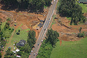
Washington State Flood - November 2006
Severe flooding in Washington state closed Mount Rainier National ParkMount Rainier National Park
Mount Rainier National Park is a United States National Park located in southeast Pierce County and northeast Lewis County in Washington state. It was one of the US's earliest National Parks, having been established on March 2, 1899 as the fifth national park in the United States. The park contains...
and damaged several mountain towns, including North Bend
North Bend, Washington
North Bend is a city in King County, Washington, United States. The town was made famous by David Lynch's television series Twin Peaks Since the Weyerhaeuser sawmill closed, North Bend has become an upscale bedroom community for the Eastside of Seattle, Washington, with property values more than...
.
2007 Midwest flooding - August 2007
A stalled frontal boundaryStationary front
A stationary front is a boundary between two different air masses, neither of which is strong enough to replace the other. On a weather map, this is shown by an inter-playing series of blue spikes pointing one direction and red domes pointing the other. They tend to remain essentially in the same...
stretching from Iowa
Iowa
Iowa is a state located in the Midwestern United States, an area often referred to as the "American Heartland". It derives its name from the Ioway people, one of the many American Indian tribes that occupied the state at the time of European exploration. Iowa was a part of the French colony of New...
to Ohio
Ohio
Ohio is a Midwestern state in the United States. The 34th largest state by area in the U.S.,it is the 7th‑most populous with over 11.5 million residents, containing several major American cities and seven metropolitan areas with populations of 500,000 or more.The state's capital is Columbus...
was the focus for several rounds of heavy rainfall resulting in flash flooding the week August 18 – August 25, 2007. Minnesota
Minnesota
Minnesota is a U.S. state located in the Midwestern United States. The twelfth largest state of the U.S., it is the twenty-first most populous, with 5.3 million residents. Minnesota was carved out of the eastern half of the Minnesota Territory and admitted to the Union as the thirty-second state...
, Iowa, Wisconsin
Wisconsin
Wisconsin is a U.S. state located in the north-central United States and is part of the Midwest. It is bordered by Minnesota to the west, Iowa to the southwest, Illinois to the south, Lake Michigan to the east, Michigan to the northeast, and Lake Superior to the north. Wisconsin's capital is...
, Illinois
Illinois
Illinois is the fifth-most populous state of the United States of America, and is often noted for being a microcosm of the entire country. With Chicago in the northeast, small industrial cities and great agricultural productivity in central and northern Illinois, and natural resources like coal,...
, Indiana
Indiana
Indiana is a US state, admitted to the United States as the 19th on December 11, 1816. It is located in the Midwestern United States and Great Lakes Region. With 6,483,802 residents, the state is ranked 15th in population and 16th in population density. Indiana is ranked 38th in land area and is...
and Ohio were the states hardest hit. Across the six states, 18 counties were declared federal disaster areas. Numerous rainfall records, both for most rain in the month of August as well as 24 hour rainfall totals were recorded. Over 457 mm (18 in) of rain was recorded in some locations during this week. At least $100 million in damages has been reported in Minnesota and Wisconsin alone, and 18 people were killed.
2007 Oregon and Washington floods - December 2007
Flooding occurred in Oregon and Washington along with high winds. Interstate 5Interstate 5
Interstate 5 is the main Interstate Highway on the West Coast of the United States, running largely parallel to the Pacific Ocean coastline from Canada to Mexico . It serves some of the largest cities on the U.S...
was both closed and damaged.
2008 Midwest flooding - Spring 2008
Flooding occurred in the midwest part of the United States.June 2008 Midwest Flood
Extensive flooding is occurring or has occurred on the WabashWabash River
The Wabash River is a river in the Midwestern United States that flows southwest from northwest Ohio near Fort Recovery across northern Indiana to southern Illinois, where it forms the Illinois-Indiana border before draining into the Ohio River, of which it is the largest northern tributary...
, White
White River (Indiana)
The White River is a two-forked river that flows through central and southern Indiana and is the main tributary to the Wabash River. Via the west fork, considered to be the main stem of the river by the U.S. Board on Geographic Names, the White River is long.-West Fork:The West Fork, long, is...
, Zumbro
Zumbro River
The Zumbro River is a tributary of the Mississippi River in the Driftless Area of southeastern Minnesota in the United States. It is about 50 mi long from the confluence of its principal tributaries and drains a watershed of 1,428 sq mi...
, Kickapoo
Kickapoo River
The Kickapoo River is a tributary of the Wisconsin River in the state of Wisconsin, United States. It is named for the Kickapoo Indians who occupied Wisconsin before the influx of white settlers in the early 19th century.-Watershed:...
, Wisconsin
Wisconsin River
-External links:* * * , Wisconsin Historical Society* * * *...
, Baraboo
Baraboo River
The Baraboo River is a tributary of the Wisconsin River, about 70 mi long, in south-central Wisconsin in the United States. Via the Wisconsin River, it is part of the watershed of the Mississippi River....
, Cedar
Cedar River
- Streams :* Cedar River * Cedar River , located in Minnesota and Iowa, a tributary of the Iowa River* Cedar River * Cedar River * Cedar River...
, Crawfish
Crawfish River
The Crawfish River is a tributary of the Rock River, long, in south-central Wisconsin in the United States. Via the Rock River, it is part of the watershed of the Mississippi River....
, Fox, Iowa
Iowa River
The Iowa River is a tributary of the Mississippi River in the state of Iowa in the United States. It is about long and is open to small river craft to Iowa City, about from its mouth...
, Rock
Rock River (Illinois)
The Rock River is a tributary of the Mississippi River, approximately long, in the U.S. states of Wisconsin and Illinois. It rises in southeast Wisconsin, in the Theresa Marsh near Theresa, Wisconsin in northeast Dodge County, Wisconsin approximately south of Fond du Lac, Wisconsin...
, and Des Moines
Des Moines River
The Des Moines River is a tributary river of the Mississippi River, approximately long to its farther headwaters, in the upper Midwestern United States...
rivers, as well as the upper Mississippi River
Mississippi River
The Mississippi River is the largest river system in North America. Flowing entirely in the United States, this river rises in western Minnesota and meanders slowly southwards for to the Mississippi River Delta at the Gulf of Mexico. With its many tributaries, the Mississippi's watershed drains...
, leading to extensive flooding in Iowa
Iowa
Iowa is a state located in the Midwestern United States, an area often referred to as the "American Heartland". It derives its name from the Ioway people, one of the many American Indian tribes that occupied the state at the time of European exploration. Iowa was a part of the French colony of New...
, Wisconsin
Wisconsin
Wisconsin is a U.S. state located in the north-central United States and is part of the Midwest. It is bordered by Minnesota to the west, Iowa to the southwest, Illinois to the south, Lake Michigan to the east, Michigan to the northeast, and Lake Superior to the north. Wisconsin's capital is...
, Indiana
Indiana
Indiana is a US state, admitted to the United States as the 19th on December 11, 1816. It is located in the Midwestern United States and Great Lakes Region. With 6,483,802 residents, the state is ranked 15th in population and 16th in population density. Indiana is ranked 38th in land area and is...
, Minnesota
Minnesota
Minnesota is a U.S. state located in the Midwestern United States. The twelfth largest state of the U.S., it is the twenty-first most populous, with 5.3 million residents. Minnesota was carved out of the eastern half of the Minnesota Territory and admitted to the Union as the thirty-second state...
, Michigan
Michigan
Michigan is a U.S. state located in the Great Lakes Region of the United States of America. The name Michigan is the French form of the Ojibwa word mishigamaa, meaning "large water" or "large lake"....
, and Missouri
Missouri
Missouri is a US state located in the Midwestern United States, bordered by Iowa, Illinois, Kentucky, Tennessee, Arkansas, Oklahoma, Kansas and Nebraska. With a 2010 population of 5,988,927, Missouri is the 18th most populous state in the nation and the fifth most populous in the Midwest. It...
.
September 2009 Southern Flood
See September 2009 Southern FloodA major rain event from September 16–22 which brought over ten inches of rain to
the Atlanta, Birmingham, Chattanooga, Athens areas as well as the states of Alabama, Georgia, Tennessee and North Carolina. As of September 22, 2009 in Atlanta, 9 people have been killed due to the floods.
March 2010 Southern New England Flood
A major rainfall event which lasted from March 28–30 which brought twelve inches of rain and flooded the Pawtuxet RiverPawtuxet River
The Pawtuxet River is a river in the U.S. state of Rhode Island. It flows and drains a watershed of . There are four dams along the river's length.-Course:...
, Blackstone River
Blackstone River
The Blackstone River is a river in the U.S. states of Massachusetts and Rhode Island. It flows approximately 48 mi and drains a watershed of approximately 540 sq. mi...
and numerous other rivers, lakes, ponds and streams in Rhode Island
Rhode Island
The state of Rhode Island and Providence Plantations, more commonly referred to as Rhode Island , is a state in the New England region of the United States. It is the smallest U.S. state by area...
. The flooding was the worst in Rhode Island history, as the Pawtuxet River crested over 20 feet—12 feet above flood stage, shattering the previous record by several feet. The rainstorm, which occurred during the cool, dry season, added 8.79" to an already rainy March. At 16.34" of rain, it was the wettest month on record for Rhode Island. A seasonal high tide led to severe coastal flooding in Bristol, Rhode Island
Bristol, Rhode Island
Bristol is a town in and the historic county seat of Bristol County, Rhode Island, United States. The population was 22,954 at the 2010 census. Bristol, a deepwater seaport, is named after Bristol, England....
; four of Rhode Island's counties were declared emergency disaster zones. The Warwick Mall
Warwick Mall
Warwick Mall is an enclosed shopping mall in Warwick, Rhode Island, on the north side of Interstate 295 near the junction with Interstate 95. Composed of more than of retail space, it features more than 80 stores and a food court...
in Warwick was flooded with 20 inches of water, leaving hundreds of employees out of work. A sewage treatment plant in the area failed, contaminating the rainwater with raw sewage. Hundreds of homes in Warwick, Cranston and Johnston were flooded with over a foot of contaminated water. Many towns in Southeastern Massachusetts were also effected by the flood.
May 2010 Tennessee floods
The May 2010 Tennessee floods were 1000-year floods in MiddleMiddle Tennessee
Middle Tennessee is a distinct portion of the state of Tennessee, delineated according to state law as the 41 counties in the Middle Grand Division of Tennessee....
Tennessee
Tennessee
Tennessee is a U.S. state located in the Southeastern United States. It has a population of 6,346,105, making it the nation's 17th-largest state by population, and covers , making it the 36th-largest by total land area...
, West Tennessee
West Tennessee
West Tennessee is one of the three Grand Divisions of the State of Tennessee. Of the three, it is the one that is most sharply defined geographically. Its boundaries are the Mississippi River on the west and the Tennessee River on the east...
, south-central and western Kentucky
Kentucky
The Commonwealth of Kentucky is a state located in the East Central United States of America. As classified by the United States Census Bureau, Kentucky is a Southern state, more specifically in the East South Central region. Kentucky is one of four U.S. states constituted as a commonwealth...
and northern Mississippi
Mississippi
Mississippi is a U.S. state located in the Southern United States. Jackson is the state capital and largest city. The name of the state derives from the Mississippi River, which flows along its western boundary, whose name comes from the Ojibwe word misi-ziibi...
as the result of torrential rains on May 1 and 2, 2010. Floods from these rains affected the area for several days afterwards, resulting in a number of deaths and widespread property damage.
September 2010 Minnesota/Wisconsin Flood
Flash floods put towns underwater and forced evacuations in Minnesota and Wisconsin. A strong system caused the heavy rain and flash flooding in the Upper Midwest. Some of the worse flooding came a week after the flood. Near record stage on the Minnesota riverMinnesota River
The Minnesota River is a tributary of the Mississippi River, approximately 332 miles long, in the U.S. state of Minnesota. It drains a watershed of nearly , in Minnesota and about in South Dakota and Iowa....
in New Ulm
New Ulm
New Ulm can mean:*New Ulm, Minnesota, USA*New Ulm, Texas, USA*Neu-Ulm, a town in Bavaria, Germany*Neu-Ulm in Bavaria, Germany...
, Mankato, St Peter, Jordan
Jordan, Minnesota
Jordan is a city in Scott County, Minnesota, United States. The population was 5,470 at the 2010 census.-Geography:According to the United States Census Bureau, the city has a total area of , of which, of it is land and of it is water. U.S. Highway 169; and State Highways 21 and 282 are three...
, Shakopee, Savage
Savage, Minnesota
Savage is a suburban city south-southwest of downtown Minneapolis in Scott County in the U.S. state of Minnesota. The city is situated on the south bank of the Minnesota River in a region commonly referred to as South of the River, comprising the southern portion of Minneapolis-St. Paul, the...
, and breaking records in Henderson
Henderson, Minnesota
Henderson is a city in Sibley County, Minnesota, United States. The population was 886 at the 2010 census.-Geography:According to the United States Census Bureau, the city has a total area of , of which, of it is land and of it is water....
. Records were also broken on the Cannon River and the Zumbro River
Zumbro River
The Zumbro River is a tributary of the Mississippi River in the Driftless Area of southeastern Minnesota in the United States. It is about 50 mi long from the confluence of its principal tributaries and drains a watershed of 1,428 sq mi...
.
Spring 2011 Mississippi River Floods
St. Francois County has been the hardest hit thus far. Poplar Bluff has had over 1,000 people evacuated thus far. On May 3, the US Army Corps of Engineers blasted a hole in two leveeLevee
A levee, levée, dike , embankment, floodbank or stopbank is an elongated naturally occurring ridge or artificially constructed fill or wall, which regulates water levels...
s along the Mississippi River
Mississippi River
The Mississippi River is the largest river system in North America. Flowing entirely in the United States, this river rises in western Minnesota and meanders slowly southwards for to the Mississippi River Delta at the Gulf of Mexico. With its many tributaries, the Mississippi's watershed drains...
, flooding some 200 square miles (518 km²) of Missouri
Missouri
Missouri is a US state located in the Midwestern United States, bordered by Iowa, Illinois, Kentucky, Tennessee, Arkansas, Oklahoma, Kansas and Nebraska. With a 2010 population of 5,988,927, Missouri is the 18th most populous state in the nation and the fifth most populous in the Midwest. It...
farmland in an effort to save the town of Cairo, Illinois
Cairo, Illinois
Cairo is the southernmost city in the U.S. state of Illinois. It is the county seat of Alexander County. Cairo is located at the confluence of the Mississippi and Ohio rivers. The rivers converge at Fort Defiance State Park, an American Civil War fort that was commanded by General Ulysses S. Grant...
from record-breaking flood waters. Further downriver in Memphis, Tennessee
Memphis, Tennessee
Memphis is a city in the southwestern corner of the U.S. state of Tennessee, and the county seat of Shelby County. The city is located on the 4th Chickasaw Bluff, south of the confluence of the Wolf and Mississippi rivers....
the high-end neighborhood of Harbor Town located along the river on Mud Island in Downtown Memphis has begun evacuating its 5,200 residents as flood waters rise to record-levels. Interstate 40
Interstate 40
Interstate 40 is the third-longest major east–west Interstate Highway in the United States, after I-90 and I-80. Its western end is at Interstate 15 in Barstow, California; its eastern end is at a concurrency of U.S. Route 117 and North Carolina Highway 132 in Wilmington, North Carolina...
that connects Memphis to Little Rock, Arkansas
Little Rock, Arkansas
Little Rock is the capital and the largest city of the U.S. state of Arkansas. The Metropolitan Statistical Area had a population of 699,757 people in the 2010 census...
has experienced flooding along the White River
White River (Arkansas)
The White River is a 722-mile long river that flows through the U.S. states of Arkansas and Missouri.-Course:The source of the White River is in the Boston Mountains of northwest Arkansas, in the Ozark-St. Francis National Forest southeast of Fayetteville...
where westbound lanes have been closed. Authorities expect the entire highway to be flooded, thus cutting off a major east-west route across the country. In Tunica County, Mississippi
Tunica County, Mississippi
As of the census of 2000, there were 9,227 people, 3,258 households, and 2,192 families residing in the county. The population density was 20 people per square mile . There were 3,705 housing units at an average density of 8 per square mile...
, nine casinos are located in front of the levees in accordance with Mississippi
Mississippi
Mississippi is a U.S. state located in the Southern United States. Jackson is the state capital and largest city. The name of the state derives from the Mississippi River, which flows along its western boundary, whose name comes from the Ojibwe word misi-ziibi...
law restricting gambling to water-born vessels. The hotel portion of the casinos are located on adjacent, low-lying land and have begun to flood with the rising waters. The Harrah's Casino in Tunica has reported nearly six feet of water on the ground floor of the hotel tower.
September 2011 Mid-Atlantic Flooding
In early September, the remnants of Tropical Storm Lee had stalled due to Hurricane Katia. As a result, the main cyclone stalled over the Midwest, and a cold frontCold front
A cold front is defined as the leading edge of a cooler mass of air, replacing a warmer mass of air.-Development of cold front:The cooler and denser air wedges under the less-dense warmer air, lifting it...
associated with Lee stalled over the Northeastern states. This drew tropical moisture into the Mid-Atlantic. Over 1 1/2 feet of rain fell in some areas from September 3 to September 7. Moisture from Hurricane Irene had already saturated the ground little over a week before, leaving the runoff plunging straight into waterways. Streams and creaks throughout the region flooded, as well as moderate flooding of the Delaware River
Delaware River
The Delaware River is a major river on the Atlantic coast of the United States.A Dutch expedition led by Henry Hudson in 1609 first mapped the river. The river was christened the South River in the New Netherland colony that followed, in contrast to the North River, as the Hudson River was then...
in some spots.
The worst of the flooding stayed in the Susquehanna River
Susquehanna River
The Susquehanna River is a river located in the northeastern United States. At long, it is the longest river on the American east coast that drains into the Atlantic Ocean, and with its watershed it is the 16th largest river in the United States, and the longest river in the continental United...
area. Both the West Branch and North Branch, as well as most of their tributaries, flooded. Flood damage was sustained in a swath from southern New York
New York
New York is a state in the Northeastern region of the United States. It is the nation's third most populous state. New York is bordered by New Jersey and Pennsylvania to the south, and by Connecticut, Massachusetts and Vermont to the east...
to the mouth, located at Havre De Grace in northern Maryland
Maryland
Maryland is a U.S. state located in the Mid Atlantic region of the United States, bordering Virginia, West Virginia, and the District of Columbia to its south and west; Pennsylvania to its north; and Delaware to its east...
. Record flooding occurred in northeastern and central Pennsylvania
Pennsylvania
The Commonwealth of Pennsylvania is a U.S. state that is located in the Northeastern and Mid-Atlantic regions of the United States. The state borders Delaware and Maryland to the south, West Virginia to the southwest, Ohio to the west, New York and Ontario, Canada, to the north, and New Jersey to...
. In Wilkes-Barre, the water was measured at 42.66 feet, an astounding number compared to the record of 40.90 feet Hurricane Agnes
Hurricane Agnes
Hurricane Agnes was the first tropical storm and first hurricane of the 1972 Atlantic hurricane season. A rare June hurricane, it made landfall on the Florida Panhandle before moving northeastward and ravaging the Mid-Atlantic region as a tropical storm...
set in 1972. Municipalities along the river sustained major damage, many househoulds and businesses among them declared condemned. The town of Bloomsburg sustained record flood levels, not seen since the flood of 1914 inundated the area. Many homes along U.S. Route 11
U.S. Route 11
U.S. Route 11 is a north–south United States highway extending 1,645 miles across the eastern United States. The southern terminus of the route is at U.S. Route 90 in the Bayou Sauvage National Wildlife Refuge in eastern New Orleans, Louisiana. The northern terminus is at the United...
had sunken into their foundations, others being stucturely unsound. The Bloomsburg Fair, an event in the town since 1855, was canceled for the first time.
Damages for the disaster will be in the tens of millions (USD), if not hundreds.
See also
- Floods in the United States until 1900Floods in the United States until 1900Floods in the United States until 1900 is a list of significant floods which have struck the United States up to 1900. Floods are generally caused by excessive rainfall, excessive snowmelt, and dam failure...
- Floods in the United States: 1901-2000
- Southwest floods of 2006
- United States tropical cyclone rainfall climatologyUnited States tropical cyclone rainfall climatologyThe United States tropical cyclone rainfall climatology concerns the amount of precipitation, primarily in the form of rain, which occurs during tropical cyclones and their extratropical cyclone remnants across the United States...