
Ems
Encyclopedia
The Ems is a river
in northwestern Germany
and the northeastern Netherlands
. It runs through the states
of North Rhine-Westphalia
and Lower Saxony
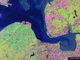
, and discharges into the Wadden Sea
. Its total length is 371 km. The state border
between the Lower Saxon area of East Friesland (Germany) and the province
of Groningen
(Netherlands), whose exact course is the subject of a border dispute between Germany and the Netherlands, runs through the Ems estuary.
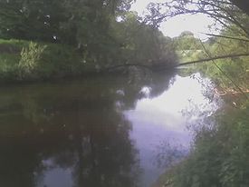
in North Rhine-Westphalia. In Lower Saxony the brook becomes a comparatively large river. Here the swampy region of Emsland
is named after the river. In Meppen
the Ems is joined by its largest tributary, the Hase
River. It then flows northwards, close to the Dutch
border, into East Frisia
. Near Emden
it flows into the Dutch Dollard bay (a national park
) and then continues as a tidal river
towards the Dutch city of Delfzijl
.
Between Emden and Delfzijl, the Ems forms the border between the Netherlands and Germany and is subject to mild dispute: the Dutch believe that the border runs through the geographical centre of the estuary
, whereas the Germans claim it runs through the deepest channel
(which is close to the Dutch coast
). As the parties are friendly states with an open border, the argument goes no further than an agreement to disagree.
Past Delfzijl, the Ems discharges into the Wadden Sea
, part of the North Sea
. The two strait
s that separate the German island
of Borkum
from its neighbours Rottumeroog
(Netherlands) and Memmert
(Germany) continue the name "Ems", as they are called Westere(e)ms and Osterems (West and East Ems).
 The Ems is accompanied and crossed by different long-distance bicycle routes:
in Natural History (4.14), Tacitus
in the Annals (Book 1), Pomponius Mela
(3.3), Strabo
and Ptolemy
, Geography (2.10). Ptolemy's name for it was the Amisios potamos, and in Latin
Amisius fluvius. The others used the same, or Amisia, or Amasia or Amasios. The identification is certain, as it always is listed between the Rhine and the Weser, and was the only river leading to the Teutoburg Forest
.
The Amisius flowed from the Teutoburg Forest
, home of the Cherusci
, with the Bructeri
and others bordering the river. These tribes were among the initial Franks
. The Romans were quite interested in adding them to the empire, and to that end built a fort, Amisia, at the mouth of the Ems. As the river was navigable to their ships, they hoped to use it to access the tribes at its upper end.
Surrounding the river for most of its length, however, were swamps, bogs and marshes. The Romans found they had no place to stand, could not pick the most favourable ground, because there was none, and could not in general follow the strategies and tactics developed by the Roman army
. They were stopped at the Battle of Teutoburg Forest, 9 AD, and were checked again 6 years later. The Ems became a road leading nowhere for them, nor were they ever able to bridge the swamps satisfactorily with causeways.
Construction of canals in more modern times connected the Ems to other waterways, opening it as a highway of industrial transportation.
River
A river is a natural watercourse, usually freshwater, flowing towards an ocean, a lake, a sea, or another river. In a few cases, a river simply flows into the ground or dries up completely before reaching another body of water. Small rivers may also be called by several other names, including...
in northwestern Germany
Germany
Germany , officially the Federal Republic of Germany , is a federal parliamentary republic in Europe. The country consists of 16 states while the capital and largest city is Berlin. Germany covers an area of 357,021 km2 and has a largely temperate seasonal climate...
and the northeastern Netherlands
Netherlands
The Netherlands is a constituent country of the Kingdom of the Netherlands, located mainly in North-West Europe and with several islands in the Caribbean. Mainland Netherlands borders the North Sea to the north and west, Belgium to the south, and Germany to the east, and shares maritime borders...
. It runs through the states
States of Germany
Germany is made up of sixteen which are partly sovereign constituent states of the Federal Republic of Germany. Land literally translates as "country", and constitutionally speaking, they are constituent countries...
of North Rhine-Westphalia
North Rhine-Westphalia
North Rhine-Westphalia is the most populous state of Germany, with four of the country's ten largest cities. The state was formed in 1946 as a merger of the northern Rhineland and Westphalia, both formerly part of Prussia. Its capital is Düsseldorf. The state is currently run by a coalition of the...
and Lower Saxony
Lower Saxony
Lower Saxony is a German state situated in north-western Germany and is second in area and fourth in population among the sixteen states of Germany...
, and discharges into the Wadden Sea
Wadden Sea
The Wadden Sea is an intertidal zone in the southeastern part of the North Sea. It lies between the coast of northwestern continental Europe and the range of Frisian Islands, forming a shallow body of water with tidal flats and wetlands. It is rich in biological diversity...
. Its total length is 371 km. The state border
Border
Borders define geographic boundaries of political entities or legal jurisdictions, such as governments, sovereign states, federated states and other subnational entities. Some borders—such as a state's internal administrative borders, or inter-state borders within the Schengen Area—are open and...
between the Lower Saxon area of East Friesland (Germany) and the province
Province
A province is a territorial unit, almost always an administrative division, within a country or state.-Etymology:The English word "province" is attested since about 1330 and derives from the 13th-century Old French "province," which itself comes from the Latin word "provincia," which referred to...
of Groningen
Groningen (province)
Groningen [] is the northeasternmost province of the Netherlands. In the east it borders the German state of Niedersachsen , in the south Drenthe, in the west Friesland and in the north the Wadden Sea...
(Netherlands), whose exact course is the subject of a border dispute between Germany and the Netherlands, runs through the Ems estuary.
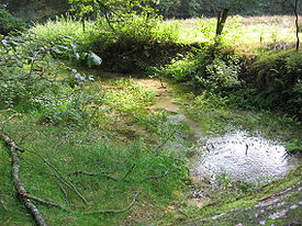
River course
The source of the river is in the southern Teutoburg ForestTeutoburg Forest
The Teutoburg Forest is a range of low, forested mountains in the German states of Lower Saxony and North Rhine-Westphalia which used to be believed to be the scene of a decisive battle in AD 9...
in North Rhine-Westphalia. In Lower Saxony the brook becomes a comparatively large river. Here the swampy region of Emsland
Emsland
Landkreis Emsland is a district in Lower Saxony, Germany named after the river Ems. It is bounded by the districts of Leer, Cloppenburg and Osnabrück, the state of North Rhine-Westphalia , the district of Bentheim and the Netherlands .- History :For a long time the region of the Emsland was...
is named after the river. In Meppen
Meppen, Germany
Meppen is a town in and the seat of the Emsland district of Lower Saxony, Germany, at the confluence of the Ems, Hase, and Nordradde rivers and the Dortmund-Ems canal...
the Ems is joined by its largest tributary, the Hase
Hase
The Hase is a 193 km long river in Lower Saxony, Germany. It is a right tributary of the Ems, but part of its flow goes to the Else, that is part of the Weser basin. Its source is in the Teutoburg Forest, south-east of Osnabrück, on the north slope of the 307 m high Hankenüll hill.- Weser-Ems...
River. It then flows northwards, close to the Dutch
Netherlands
The Netherlands is a constituent country of the Kingdom of the Netherlands, located mainly in North-West Europe and with several islands in the Caribbean. Mainland Netherlands borders the North Sea to the north and west, Belgium to the south, and Germany to the east, and shares maritime borders...
border, into East Frisia
East Frisia
East Frisia or Eastern Friesland is a coastal region in the northwest of the German federal state of Lower Saxony....
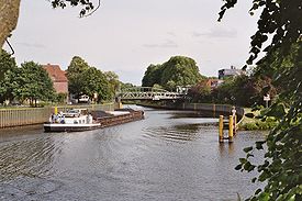
. Near Emden
Emden
Emden is a city and seaport in the northwest of Germany, on the river Ems. It is the main city of the region of East Frisia; in 2006, the city had a total population of 51,692.-History:...
it flows into the Dutch Dollard bay (a national park
National park
A national park is a reserve of natural, semi-natural, or developed land that a sovereign state declares or owns. Although individual nations designate their own national parks differently A national park is a reserve of natural, semi-natural, or developed land that a sovereign state declares or...
) and then continues as a tidal river
River
A river is a natural watercourse, usually freshwater, flowing towards an ocean, a lake, a sea, or another river. In a few cases, a river simply flows into the ground or dries up completely before reaching another body of water. Small rivers may also be called by several other names, including...
towards the Dutch city of Delfzijl
Delfzijl
Delfzijl is a municipality and city in the northeast of the Netherlands. It is situated on the left bank of the river Ems estuary, which forms the border with Germany.-Population centres:...
.
Between Emden and Delfzijl, the Ems forms the border between the Netherlands and Germany and is subject to mild dispute: the Dutch believe that the border runs through the geographical centre of the estuary
Estuary
An estuary is a partly enclosed coastal body of water with one or more rivers or streams flowing into it, and with a free connection to the open sea....
, whereas the Germans claim it runs through the deepest channel
Channel (geography)
In physical geography, a channel is the physical confine of a river, slough or ocean strait consisting of a bed and banks.A channel is also the natural or human-made deeper course through a reef, sand bar, bay, or any shallow body of water...
(which is close to the Dutch coast
Coast
A coastline or seashore is the area where land meets the sea or ocean. A precise line that can be called a coastline cannot be determined due to the dynamic nature of tides. The term "coastal zone" can be used instead, which is a spatial zone where interaction of the sea and land processes occurs...
). As the parties are friendly states with an open border, the argument goes no further than an agreement to disagree.
Past Delfzijl, the Ems discharges into the Wadden Sea
Wadden Sea
The Wadden Sea is an intertidal zone in the southeastern part of the North Sea. It lies between the coast of northwestern continental Europe and the range of Frisian Islands, forming a shallow body of water with tidal flats and wetlands. It is rich in biological diversity...
, part of the North Sea
North Sea
In the southwest, beyond the Straits of Dover, the North Sea becomes the English Channel connecting to the Atlantic Ocean. In the east, it connects to the Baltic Sea via the Skagerrak and Kattegat, narrow straits that separate Denmark from Norway and Sweden respectively...
. The two strait
Strait
A strait or straits is a narrow, typically navigable channel of water that connects two larger, navigable bodies of water. It most commonly refers to a channel of water that lies between two land masses, but it may also refer to a navigable channel through a body of water that is otherwise not...
s that separate the German island
Island
An island or isle is any piece of sub-continental land that is surrounded by water. Very small islands such as emergent land features on atolls can be called islets, cays or keys. An island in a river or lake may be called an eyot , or holm...
of Borkum
Borkum
Borkum is an island and a municipality in the Leer District in Lower Saxony, northwestern Germany.-Geography:Borkum is bordered to the west by the Westerems strait , to the east by the Osterems strait, to the north by the North Sea, and to the south by the Wadden Sea...
from its neighbours Rottumeroog
Rottumeroog
Rottumeroog is one of the three islands that make up Rottum, a group of islands that are part of the West Frisian Islands archipelago. The island is situated off the Dutch coast in the North Sea. The island is named after the village Rottum in Groningen: the Benedictine "St...
(Netherlands) and Memmert
Memmert
Memmert is a small East Frisian island off the northern coast of Germany, with an area of . Memmert is uninhabited, with only one house on the island for wildlife-spotting purposes. Occasionally, some guests from the neighboring islands visit Memmert for recreation...
(Germany) continue the name "Ems", as they are called Westere(e)ms and Osterems (West and East Ems).
Tourism
- EmsAuenWegEmsAuenWegThe EmsAuenWeg is a 115 kilometer long-distance cycle path in Münsterland opened in 2004. The EmsAuenWeg leads past the middle Ems over the village Telgte at Münster. It follows the path of the Rheine through Greven, Saerbeck, and Emsdetten. The path is parallel to railroad lines....
- Emsland Route
- Hase Ems Weg
Cities and municipalities at the Ems
- Schloß Holte-StukenbrockSchloß Holte-StukenbrockSchloß Holte-Stukenbrock is a town in the district of Gütersloh in the state of North Rhine-Westphalia, Germany. It is located near the Eggegebirge, approx. 15 km east of Gütersloh and 15 km south-east of Bielefeld. It is the source of the Ems River....
- HövelhofHövelhofHövelhof is a municipality in the district Paderborn, in North Rhine-Westphalia, Germany.-Geography:Hövelhof is located in the Senne area, the eastern part of the Westfälische Bucht, approx...
- SteinhorstSteinhorstSteinhorst may refer to the following places in Germany:*Steinhorst, Schleswig-Holstein, a municipality in the district of Lauenburg, Schleswig-Holstein*Steinhorst, Lower Saxony, a municipality in the district of Gifhorn, Lower Saxony...
- Westerwiehe
- Schöning
- RietbergRietbergRietberg is a town in the district of Gütersloh in the state of North Rhine-Westphalia, Germany. It is located approx. 10 km south of Gütersloh and 25 km north-west of Paderborn in the region Ostwestfalen-Lippe. The town is located at the river Ems. There are 28,878 people living in...
- Rheda-WiedenbrückRheda-WiedenbrückRheda-Wiedenbrück is a town in the district of Gütersloh, in North Rhine-Westphalia, Germany.-Geography:Rheda-Wiedenbrück is located on the river Ems, approx. 10 km south-west of Gütersloh.-Neighbouring municipalities:* Oelde* Herzebrock-Clarholz...
- HarsewinkelHarsewinkelHarsewinkel is a town in Gütersloh District in the state of North Rhine-Westphalia, Germany. It lies on the river Ems, some 15 km north-west of Gütersloh....
- WarendorfWarendorfWarendorf is a town in North Rhine-Westphalia, Germany, and capital of Warendorf District.The town is best known today for its well-preserved medieval town centre, for horse-riding, and the opportunities it provides for cycling...
- TelgteTelgteTelgte is a town in the Warendorf district, North Rhine-Westphalia, Germany. It is situated on the river Ems, 10 km east of Münster, and 15 km west of Warendorf.-History:...
- GrevenGrevenGreven is a medium-sized town in the district of Steinfurt, in Germany's most populous state of North Rhine-Westphalia and close to the city of Münster.-Geography:Greven is situated on the river Ems, approx...
- EmsdettenEmsdettenEmsdetten is a town in the district of Steinfurt, in North Rhine-Westphalia, Germany.- Geography :Emsdetten is situated on the river Ems, approx...
- RheineRheineRheine is a city in the district of Steinfurt in Westphalia, Germany. It is the largest city in the district and the location of Rheine Air Base.-Geography:Rheine is located on the river Ems, approx. north of Münster, approx...
- SalzbergenSalzbergenSalzbergen is a municipality in the Emsland district, Lower Saxony, Germany. It is situated on the river Ems, approx. 25 km south of Lingen, and 10 km northwest of Rheine.It has the oldest oil refinery in the world, opened in 1860....
- EmsbürenEmsbürenEmsbüren is a municipality in the Emsland district, Lower Saxony, Germany. It is situated on the river Ems, approx. 15 km south of Lingen, and 15 km northwest of Rheine.It has a railway station: Leschede....
- LingenLingenLingen is a town in Lower Saxony, Germany. In 2008 the population was 52,353, and in addition there are about 5,000 people who have registered the city as their secondary residence...
- GeesteGeesteGeeste is a municipality in the district Emsland in Lower Saxony.Situation of the local parts in the municipality of Geeste:-External links:*...
- MeppenMeppen, GermanyMeppen is a town in and the seat of the Emsland district of Lower Saxony, Germany, at the confluence of the Ems, Hase, and Nordradde rivers and the Dortmund-Ems canal...
- HarenHaren- Places :* Haren, Groningen, Netherlands* Haren, North Brabant, Netherlands* Haren, Belgium, Brussels, Belgium* Haren, Germany, Lower Saxony, Germany...
- LathenLathenSamtgemeinde Lathen is a Samtgemeinde in the district Emsland in Lower Saxony, Germany.Following towns are situated in Lathen:...
- Kluse
- DörpenDörpenSamtgemeinde Dörpen is a Samtgemeinde in the district Emsland in Lower Saxony, Germany.Following towns are situated in Dörpen:...
- LeheLeheLehe may refer to the following places in Germany:*Lehe, Lower Saxony, a municipality in the district of Emsland, Lower Saxony "*Lehe, Schleswig-Holstein, a municipality in the district of Dithmarschen, Schleswig-Holstein...
- Aschendorf
- TunxdorfTunxdorfTunxdorf is a little village belonging to Papenburg, Lower Saxony, Germany. Along with the neighbor village Nenndorf it constitutes the "Tunxdorf-Nenndorf" district of Papenburg...
- PapenburgPapenburgPapenburg is a city in the district of Emsland in Lower Saxony, Germany, situated at the river Ems. It is known for its large shipyard, the Meyer-Werft, which specializes in building cruise liners.-Districts:...
- WeenerWeenerWeener is a town in the district of Leer, in Lower Saxony, Germany. It is situated near the border with the Netherlands, on the river Ems, approx. 10 km southwest of Leer, and 25 km southeast of Emden...
- LeerLeerLeer is a town in the district of Leer, the northwestern part of Lower Saxony, Germany. It is situated at the river Ems, near the border with the Netherlands....
- JemgumJemgumJemgum is a municipality in the Leer district, in the northwest of Lower Saxony, Germany. The area is known as Rheiderland or Reiderland . The Rheiderland is located in East Friesland....
- MidlumMidlum, Lower SaxonyMidlum is a municipality in the district of Cuxhaven, in Lower Saxony, Germany.The Land of Wursten, a rather autonomous farmers' republic including Midlum, had long been claimed by the Prince-Archbishopric of Bremen, until in 1524 it could be definitely be subjected...
- Critzum
- Rorichum
- Gandersum
- EmdenEmdenEmden is a city and seaport in the northwest of Germany, on the river Ems. It is the main city of the region of East Frisia; in 2006, the city had a total population of 51,692.-History:...
- Knock
- DelfzijlDelfzijlDelfzijl is a municipality and city in the northeast of the Netherlands. It is situated on the left bank of the river Ems estuary, which forms the border with Germany.-Population centres:...
Tributaries of the Ems
- WapelbachWapelbachWapelbach is a river of North Rhine-Westphalia, Germany....
- DalkeDalkeDalke is a river of North Rhine-Westphalia, Germany....
- Lutter
- AxtbachAxtbachAxtbach is a river of North Rhine-Westphalia, Germany.-See also:*List of rivers of North Rhine-Westphalia...
- HesselHesselThe Hessel is a long, right tributary of the River Ems in the territory of the North Rhine-Westphalian districts of Gütersloh and Warendorf in northwest Germany....
- BeverBever (Ems)The Bever is an approximately 20 km long river in western Germany, right tributary of the river Ems. It has its springs in the Teutoburg Forest. It runs though the northern part of North Rhine-Westphalia and flows into the Ems near Telgte . Another town on the Bever is Ostbevern....
- WerseWerseThe Werse is a 67 km long, left-hand tributary of the River Ems in Münsterland, North Rhine-Westphalia in Germany. The catchment area of the Werse is 762.47 km². Its name may be derived from a pre-Indo-European language, Vasconic, from which the Basque language developed. Its water...
- Eltingmühlenbach
- Große AaGroße AaThe Große Aa is a 25 km long, right, eastern tributary of the River Ems in western Lower Saxony .It begins in the collective municipality of Freren, near the quarter of Overwater, at the confluence of the Deeper Aa and Ahe rivers. From there is flows through Lünne westwards to Hesselte, where...
- HaseHaseThe Hase is a 193 km long river in Lower Saxony, Germany. It is a right tributary of the Ems, but part of its flow goes to the Else, that is part of the Weser basin. Its source is in the Teutoburg Forest, south-east of Osnabrück, on the north slope of the 307 m high Hankenüll hill.- Weser-Ems...
- NordraddeNordraddeNordradde is a river of Lower Saxony, Germany....
- LedaLeda RiverThe Leda is a river in north-western Germany , right tributary of the Ems. It originates at the confluence of the Sagter Ems and the Soeste near the town Barßel. The Leda flows into the Ems near the city Leer...
The Ems in history
The Ems was known to several ancient authors: Pliny the ElderPliny the Elder
Gaius Plinius Secundus , better known as Pliny the Elder, was a Roman author, naturalist, and natural philosopher, as well as naval and army commander of the early Roman Empire, and personal friend of the emperor Vespasian...
in Natural History (4.14), Tacitus
Tacitus
Publius Cornelius Tacitus was a senator and a historian of the Roman Empire. The surviving portions of his two major works—the Annals and the Histories—examine the reigns of the Roman Emperors Tiberius, Claudius, Nero and those who reigned in the Year of the Four Emperors...
in the Annals (Book 1), Pomponius Mela
Pomponius Mela
Pomponius Mela, who wrote around AD 43, was the earliest Roman geographer. He was born in Tingentera and died c. AD 45.His short work occupies less than one hundred pages of ordinary print. It is laconic in style and deficient in method, but of pure Latinity, and occasionally relieved by pleasing...
(3.3), Strabo
Strabo
Strabo, also written Strabon was a Greek historian, geographer and philosopher.-Life:Strabo was born to an affluent family from Amaseia in Pontus , a city which he said was situated the approximate equivalent of 75 km from the Black Sea...
and Ptolemy
Ptolemy
Claudius Ptolemy , was a Roman citizen of Egypt who wrote in Greek. He was a mathematician, astronomer, geographer, astrologer, and poet of a single epigram in the Greek Anthology. He lived in Egypt under Roman rule, and is believed to have been born in the town of Ptolemais Hermiou in the...
, Geography (2.10). Ptolemy's name for it was the Amisios potamos, and in Latin
Latin
Latin is an Italic language originally spoken in Latium and Ancient Rome. It, along with most European languages, is a descendant of the ancient Proto-Indo-European language. Although it is considered a dead language, a number of scholars and members of the Christian clergy speak it fluently, and...
Amisius fluvius. The others used the same, or Amisia, or Amasia or Amasios. The identification is certain, as it always is listed between the Rhine and the Weser, and was the only river leading to the Teutoburg Forest
Teutoburg Forest
The Teutoburg Forest is a range of low, forested mountains in the German states of Lower Saxony and North Rhine-Westphalia which used to be believed to be the scene of a decisive battle in AD 9...
.
The Amisius flowed from the Teutoburg Forest
Teutoburg Forest
The Teutoburg Forest is a range of low, forested mountains in the German states of Lower Saxony and North Rhine-Westphalia which used to be believed to be the scene of a decisive battle in AD 9...
, home of the Cherusci
Cherusci
The Cherusci were a Germanic tribe that inhabited parts of the northern Rhine valley and the plains and forests of northwestern Germany, in the area between present-day Osnabrück and Hanover, during the 1st century BC and 1st century AD...
, with the Bructeri
Bructeri
The Bructeri were a Germanic tribe located in northwestern Germany , between the Lippe and Ems rivers south of the Teutoburg Forest, in present-day North Rhine-Westphalia around 100 BC through 350 AD....
and others bordering the river. These tribes were among the initial Franks
Franks
The Franks were a confederation of Germanic tribes first attested in the third century AD as living north and east of the Lower Rhine River. From the third to fifth centuries some Franks raided Roman territory while other Franks joined the Roman troops in Gaul. Only the Salian Franks formed a...
. The Romans were quite interested in adding them to the empire, and to that end built a fort, Amisia, at the mouth of the Ems. As the river was navigable to their ships, they hoped to use it to access the tribes at its upper end.
Surrounding the river for most of its length, however, were swamps, bogs and marshes. The Romans found they had no place to stand, could not pick the most favourable ground, because there was none, and could not in general follow the strategies and tactics developed by the Roman army
Roman army
The Roman army is the generic term for the terrestrial armed forces deployed by the kingdom of Rome , the Roman Republic , the Roman Empire and its successor, the Byzantine empire...
. They were stopped at the Battle of Teutoburg Forest, 9 AD, and were checked again 6 years later. The Ems became a road leading nowhere for them, nor were they ever able to bridge the swamps satisfactorily with causeways.
Construction of canals in more modern times connected the Ems to other waterways, opening it as a highway of industrial transportation.