

Ditton, Kent
Encyclopedia
Ditton is a large village and civil parish
in the Tonbridge and Malling District
of Kent
, England. The village is about 5 miles (8 km) north-west of Maidstone
town centre and 1.8 miles (2.9 km) east of West Malling
. The parish, which is long and narrow, straddles the A20 (the old Dover
to London
road), with farmland to the south and industry to the north. It lies in the Medway Valley, on the northern edge of the Kent Weald
, and adjoins the ancient parishes of Larkfield, Aylesford
and Barming
.
The origins of the village can be traced to the stream which runs through the parish and gave rise to a number of corn mills along its length. The earliest recorded mention of the village is in the Domesday Book
of 1086. The village contains a number of listed buildings, which include a 12th century church, an old mill house and two oast houses.
More recently, ragstone
and newsprint industries have developed and become important sources of local employment. The population of the village grew rapidly with the overspill of housing from the nearby town of Maidstone. Today Ditton has a mixed agricultural and industrial economy, with a wide range of social and leisure facilities. In 2001 it had a population of 4,753.
Ditton has extensive transport links, being close to the M20 motorway and the national railway network with its regular connections to London. The Channel Tunnel
is within easy driving distance and the village is twinned with Rang-du-Fliers
in the Pas-de-Calais department of the Nord-Pas-de-Calais region of France
.
 The name Ditton comes from the Saxon "Dictune" meaning the village situated on the dike, or trench of water. This derives from the Bradbourne Stream
which rises near East Malling and passes through the village. Today the stream supplies the Aylesford Newsprint site, the largest paper recycling factory in Europe, with part of its water supply.
Evidence of the early occupation of Ditton is scant. A Mesolithic
tranchet axe, a sharpening flake, three microliths and 36 blades were found at Ditton, but the exact site of the find is now unknown. Mesolithic flint implements, Iron Age pottery and pit dwellings have also been reported in the Holt Hill area of Ditton.
An Anglo-Saxon
spearhead was found in July 1962 by D. Tamkin in a cutting through a natural knoll of sand on Messrs Reed's playing fields at Cobdown, Ditton. It is possible that the spearhead came from a grave on the top of the knoll, destroyed during the making or widening of the cutting.
The first recorded mention of Ditton is in the Domesday Book, with an entry dated 1086. At that time the village had 31 dwellings. The Domesday Book states: "Haimo the sheriff holds of the bishop (of Baieux
) Dictune. It was taxed at one suling. The arable land is four carucates. In demesne
there are two, and 20 villeins, with five borderers, having three carucates. There is a church and 6 servants, and one mill of 10 shillings, and eight acres of meadow, and 35 acres of pasture. Wood for the pannage
of six hogs. In the time of King Edward the Confessor
it was worth 8 pounds, when he received it 100 shillings, now 8 pounds. Sbern held it of King Edward."
There was another estate in the parish at that time called Sifletone, which also belonged to the Bishop of Baieux (Bayeux), and was entered into the Domesday Book: "Vitalis holds of the bishop (of Baieux) Sifletone. It was taxed at three yokes
. The arable land is one carucate. In demesne there is one caracate and an half, and six villeins, with one borderer, having half a carucate. There are six servants, and one mill of 10s. There are ten acres of meadow, and thirty acres of pasture. In the time of the Confessor it was worth 40 shillings, when he received it four pounds, now 100 shillings. In the time of king Edward the Confessor, two men, Leuuin and Uluuin, held this land in coparcenary
, and could turn themselves over with this land to whomever they would."
Thus there were three manors within the parish; Ditton Manor, with the appendant Brampton Manor, and Sifletone, all of which were owned by the Bishop of Bayeux at this time. The Bishop of Bayeaux was Odo, Earl of Kent, half brother of William the Conqueror. In 1082, after it was discovered that Odo planned a military expedition to Italy, he was imprisoned and his estates (including Ditton, Brampton and Sifletone) were confiscated to the Crown. Following this, Ditton Manor appears to have been held by the Clares, earls of Gloucester, by a family who assumed their surname from Ditton. Likewise, Sifletone was confiscated and went to another family who took their surname from it.
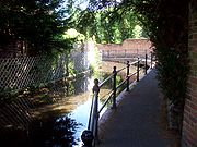
Ditton has a ford
which, along with St Peter's Ad Vincula's Church, is situated in a conservation area on the west of a large green. The church is dated to the 12th century with a later 14th-century tower and the first bell of Ditton church was hung there in 1656. Ditton parish register has as its opening words, "The Register book of Ditton beginning Anno Dom. 1663. William Jole, rector, inducted Rector of Ditton, 1st August, Anno Dom. 1663." Also at the commencement it is recorded, on 1 August 1711, that every acre of woodland in the parish of Ditton by immemorial custom pays tithe to the rector. In 1798 Ditton was recorded as being within the ecclesiastical jurisdiction of the Diocese of Rochester
, and deanery of Malling. This parish, among others, was obliged to contribute to the repair of the fifth pier of Rochester bridge. The church was restored
in 1860 by Sir George Gilbert Scott.
The north nave window has fragments of fourteenth-century glass, and the nave has a good selection of hanging wall monuments and a benefactions board. A lead plaque on the nave wall, removed from the tower roof in 1859, has a picture of a ship from Nelson's time scratched on it. The mill that was recorded in the Domesday Book, Church Mills, was located close to the ford and closed down around 1912.
In 1798 the parish was described in the following terms: "The high road from London, through Wrotham
, to Maidstone, crosses the middle of it, at the thirty-first mile stone; the village stands on it, and the church about a quarter of a mile further southward, on an ascent, beyond which, the parish reaches into the large tract of coppice woods, which extends as far as Teston
and Barming
. The stream, from Bradborne Park runs through this parish and village, across the above road, and having turned two mills, one above and the other below it, runs on to the River Medway
, which is the northern boundary of this parish, near the north-west extremity of which, on the road leading from Larkfield to Newhith
, and not far distant from that hamlet and the river, is Borough Court. This parish is rather an obscure place, and has nothing further worthy of notice in it."
The three manors (estates) of Ditton, Brampton and Sifletone were back in common ownership
in the reign of Henry VII
, when they belonged to "Thomas Leigh of Sibton in Liminge
". The subsequent history of the manors is as follows:
Ditton Manor included a mansion named Ditton Court or Ditton Place that was built in the 16th century, and stood on the present site of Troutbeck House. At the beginning of King James I's reign it was the residence of the Brewer family, many of whom lie buried in the churchyard, and remained with them until the beginning of the 18th century when, by mortgage or purchase, it came into the possession of the sheriff, Thomas Golding of Leyborne, in 1703. He bequeathed it to his nephew, Thomas Golding of Ryarsh, who sold it to John Brewer, counsellor at law. Brewer's niece, Mrs. Carney of West Farleigh, re-conveyed it back to Thomas Golding again in about 1735 and from whom his son, John Golding, inherited it. There is reference in Organa Brittanica to an organ built by renowned organ builder John Avery which was moved in the late 18th century from West Malling Parish Church to a recess in the hall of Ditton Court, described as the manor house of the area and owned by the Golding family. Ditton Place was destroyed by fire in 1987. Today a modern apartment block, named Troutbeck House, has been built on the site of Ditton Place (as shown on an 1896 map), and lies at the centre of a modern housing estate. One of the roads of the estate takes its name from the original house.
Brampton Manor probably stood on the site of the New Road Industrial Estate. After the manor was destroyed the site was known as Brampton Field, at least until the 18th Century, and indeed one of the streets of the housing estate which covers the site today is named Brampton Field.
Sifflington Manor (Sifletone) was an estate within Ditton parish and appears to have been incorporated into Ditton Manor at some stage before the 19th century.
 A manor house, Borough Court (also known as Brooke Court), stood in the northernmost part of the parish; though it no longer exists it probably stood in the vicinity of the modern Aylesford Newsprint site. The Culpepper family of Aylesford owned the house during the reign of King Edward III (1327–1377). The High Sheriff of Kent
in 1426–27, Walter Culpeper, was the owner until the house devolved onto his heirs, eventually passing to Richard Culpeper (later Sir Richard Culpepper) who also owned the manor house at Oxon Hoath
. Sir Richard Culpepper died in 1484 without issue and the house was divided amongst his three daughters, one of whom was Joyce Culpeper—whose daughter was Catherine Howard
and would become the fifth wife of King Henry VIII. The house was then sold to Francis Shakerly who hailed from Shakerly, Kent.
s.
William Boghurst was an apocethary, and native, of Ditton, who remained in London during the Great Plague
of 1665. During the plague his medical practice expanded and he made his name. He stayed in the city throughout the epidemic, treating by his own account "40, 50 or 60 patients a day". By the end of the year his reputation was sufficient to attract offers from the corporation of Norwich, which tried to employ him when the infection reached there. He wrote a book about his experience which, although not printed at the time, was subsequently published in 1894 for the London Epidemiological Society under the title Loimographia :an Account of the Great Plague of London in the year 1665. In later life his fortunes appear to have declined, as he could not afford the livery
of his company in 1682. Boghurst died on 2 September 1685 aged 54 and was conveyed from London to be buried in the churchyard at Ditton.
Thomas Tilson was the rector of Ditton from 1679–1702 and was in correspondence with the Protestant cleric Richard Baxter
. In one letter Tilson described how a woman from Rochester had gone to her father's house in West Malling
where she died on 4 June 1691. While on her death bed, at two o'clock in the morning, she appeared as an apparition to a nurse in Rochester, some nine miles away, where her children were being looked after. It had been the dying woman's wish to see her children before she died but she had been persuaded not to travel because of her ill health. Baxter included this account in his subsequent book The Certainty of the Worlds of the Spirits published in the same year. Tilson died in 1750 and his memorial in St. Peter's AD Vincula Church records a bequest he made to the poor of "£100 in money, the yearly produce to be distributed annually on the feasts of All Saints and the Purification, in wood and wheat" (see inscription in photograph).
Reverend Samuel Bishop
(1731–95) was a poet, headmaster of Merchant Taylors' school
and rector of Ditton. His posthumously published book entitled Poems (1796) was much admired and several times reprinted. Not everyone was complimentary about Bishop and his verses: "the character of Bishop's countenance is not very intellectual, and there is a timid, and almost mean expression about the mouth. He looks but little qualified to insist upon the discipline necessary to be observed at Merchant Tailor's (sic) school, or to wield the weapons of Dr. Busby
. But, we suppose, he did both occasionally, besides writing his epigrams, and composing verses to his wife, — "To Mrs. Bishop." Of this lady he sings sometimes more like the tea-kettle than the nightingale".
Thomas Golding, sheriff of Kent in 1703, was living in the nearby parish of Leybourne
when he bought Ditton Court, around the start of the 18th century. His arms were "argent, a cross voided between four lions passant, guardant gules" (a red hollow cross between four lions lying down with their heads and front paws up, on a white or silver background). He left Ditton Court to his nephew, another Thomas, who seems to have sold it and then bought it back again around 1735.
The surname Golding is synonymous with a variety of hop known as Goldings and, although it is not certain who discovered the hop, it has been accredited to John Golding (who died some time before 1811), the great nephew of Thomas and the owner of Ditton Court, or to his son John (who died at Ditton Place in 1851).
Lt. Col. Clifford Sheldon, DSO, was joint managing and senior director of Reeds, the paper manufacturer, and was connected with that firm and its associated companies from 1911 until his death in 1950 at the age of 62 years. He gave his name to the Clifford Sheldon Club House, a converted oast house
, which subsequently became the Manor and Greenside Oast.
s set up milestone
s along these roads. A series of mileposts made in cast-iron appear on the stretch of road between Aylesford and Addington; at Ditton, Larkfield and Ryarsh. The one at Larkfield is shown on an 1862 Ordnance Survey map and the Ditton post is shown on a similar map of 1869. Both the Larkfield and Ditton posts are classed as Class II listed buildings.
of Aylesford
... containing 192 inhabitants." In 1851 the population was 235 and by 1872 the population was 255, with 51 houses in the parish.
and enlarged in 1887 by the Brassey family for Jubilee of Queen Victoria. A separate infant school opened in 1973.
Ditton Infant School today caters for boys and girls from 4 to 7 years of age and shares its site with Ditton Church of England Junior School. There were 165 children on the infant school roll in 2008, the year it was inspected by Ofsted
.
Ditton Church of England Junior School is a primary school catering for mixed pupils aged 5–11 and is adjacent to the infant school. In 2008 there were 277 children on the school roll and it was inspected by Oftsed in 2010.
Aylesford School – Sports College is a secondary school situated in Teapot Lane, Aylesford, in modern buildings. Its catchment area is to the western side of Maidstone, and includes pupils from Ditton. The school is for mixed gender pupils in years 7 to 11, with a sixth form for those in years 12 and 13. In 2004 the school gained specialist status as a Sports College, with the result that the curriculum now includes an element of sports education of every aspect. In 2010 there were 944 pupils on the school roll and it was inspected by Ofsted
in the same year.
MidKent College
(formerly Mid-Kent College of Higher and Further Education) is the nearest further education
college to Ditton. Three campuses, situated in Maidstone
and Medway
, cater for around 15,000 students aged 16+. The courses offered cover a number of vocational and academic subjects starting with pre-entry level and finishing at degree level.
Ditton Heritage Centre has been established within an old Victorian building in the village to teach children in the style of a Victorian school. The classroom has been fully restored to represent a typical classroom of the Victorian era.
(12 names) and World War II
(7 names). The parade culminates at the War Memorial, which stands on the eastern side of the junction between the A20 road and New Road in Ditton. A wreath is laid on the monument by members of local groups and of the parish council.
The monument was designed by Gilbert Scott, who gifted the land the monument stands on to the village. It records the names of the military personnel who fell in the two world wars. Its design is unique among war memorials in the United Kingdom on account of the roof over the cross. The monument was dedicated and unveiled on 26 September 1920, in a ceremony attended by the Bishop of Rochester and General Archibald Murray
. The monument was granted listed building status in 2000 as a result of Ditton Parish Council approaching the War Memorial Society for assistance to repair it.
The parish of Ditton lies in the Medway valley and borders the River Medway
to the north and the Weald
to the south. The river Medway is Kent’s principal river and rises near East Grinstead
in Sussex
, flowing eastwards to Maidstone. After passing Ditton parish it turns north and cuts through the North Downs
at Rochester, joining the estuary of the River Thames
as its final tributary near Sheerness
. The Medway is some 112 kilometres (70 mi) long.
The availability of water to transport products and raw materials, and as a resource used in the manufacture of paper, was essential to the historical development of paper mills in the area. Bradbourne stream, which meanders through the parish in a south-east to north-west direction, rises in East Malling, crosses under the A20 road and M20 motorway
, and joins the river Medway near the Aylesford Newsprint site. Historically the availability of running water was essential to the early settlements that grew up in Kent, and to the establishment of industries in the area; such as providing power to drive the mills which ground grain.
Ditton is situated between the Lower Weald and the Chalk (North) Downs. The parish encompasses the Lower Greensand strata, where a formation of hard sandy limestone known as the Hythe Beds is abundant. From this formation ragstone is obtained. Kentish ragstone
was a historically important building material in south east England. The Romans used ragstone in the construction of London and villas in the south-east. Medieval builders used ragstone to build churches, civic buildings, houses and bridges over local rivers. The predominance of ragstone beds in the locality gave Ditton a legacy of quarrying which continues today.
. Since 6 May 2010 the Member of Parliament
has been the Conservative party's
Tracey Crouch
. At the 2010 general election, the Conservatives won by a majority of 6,069 with 46.2% of the vote in the constituency. Labour
won 32.3% of the vote, Liberal Democrats
13.3%, the British National Party
3.1% and the United Kingdom Independence Party
3.0%.
of whom seven represent Tonbridge & Malling residents. The remaining 11 councils in Kent are represented by the other members. Tonbridge & Malling borough is divided into six county council divisions with each division having one councillor elected to represent it, except for the Tonbridge division which has two councillors. The county council division of Malling Rural North East includes Aylesford, Burham
, Ditton and Wouldham
.
local government borough and has two of the 53 seats on the Council. As at the 2011 local elections
, eight of those seats were held by the Conservatives
and five by the Liberal Democrats
The Council now comprises: forty-eight Conservatives, four Liberal Democrats and one Labour councillor; all of who will represent local people in the 26 wards until the next elections in 2015.
As of the 2001 UK census, the Ditton electoral ward had a population of 4,753. The ethnicity was 98.3% white, 0.7% mixed race, 0.7% Asian, 0.2% black and 0.1% other. The place of birth of residents was 96.7% United Kingdom, 0.4% Republic of Ireland, 1% other Western European countries, and 1.9% elsewhere. Religion was recorded as 79.4% Christian, 0.1% Buddhist, 0.2% Hindu, 0.1% Sikh, 0.1% Jewish, and 0.4% Muslim. 12.2% were recorded as having no religion, 0.2% had an alternative religion and 7.3% did not state their religion.
The economic activity of residents aged 16–74 was 46.3% in full-time employment, 14.3% in part-time employment, 7.7% self-employed, 2% unemployed, 2.6% students with jobs, 2.3% students without jobs, 14.4% retired, 5.7% looking after home or family, 2.9% permanently sick or disabled and 1.9% economically inactive for other reasons. The industry of employment of residents was 21.9% retail, 14.1% manufacturing, 10% construction, 12% real estate, 8.7% health and social work, 6.2% education, 6.8% transport and communications, 5.2% public administration, 3.1% hotels and restaurants, 4.7% finance, 1.3% agriculture and 6% other. Compared with national figures, the ward had a relatively high proportion of workers in construction and retail, and a relatively low proportion in hotels and restaurants. Of the ward's residents aged 16–74, 12.9% had a higher education
qualification or the equivalent, compared with 19.9% nationwide.
The Medway valley has long been associated with the newsprint industry, and today the most significant surviving example is Aylesford Newsprint, which lies at the northern end of the parish. Ditton's connection with the industry goes back to 1922 when the first factory was built by Reed International on the banks of the river Medway. Reed International were a major paper manufacturer which, at its height, had in the region of 1,500 employees. The business was seriously hampered by the advent of World War II, which caused a shortage of pulp to make newspapers and led to a different material, waste paper, being used in its place. Since then waste paper has been replaced by recycled fibre, which is now fully utilised in the process of producing newsprint. Today the 60 acre plant belongs to SCA, paper manufacturers from Sweden, in partnership with Mondi and £250 million has been invested in developing the site. The business operating from the plant is called Aylesford Newsprint and is one of the world's leading manufacturers of newsprint, recycling around 500,000 tonnes of material to produce some 400,000 tonnes of final product. Media organisations in Europe, America and the Far East rely on the recycled newsprint from the plant for their publications. Ditton stream is a vital water supply for the processes carried out in the plant.
At the opposite end of the parish is part of the 23 acre East Malling Research Station
. This began in 1913 in response to a need among Kent farmers for assistance with their fruit growing activities. Since fruit was an important part of the Kent economy, the station performed a valuable role is carrying out research experiments and advising farmers on fruit production. The land that forms the research station grounds is conducive to the growing of fruit, with good water retention and drainage properties. The station was also well placed in terms of transport links, since the nearby railway connected with London in one direction and the agricultural college at Wye
in the other. It was an indication of the importance of the research station that the government and fruit producers were prepared to give financial support for its work. In 1938 the 360 acre Bradbourne House estate was added to the site. As a result of research work carried out on the site, the station established a reputation as a world centre for the research of perennial crops. Horticultural Research International operated the site until 2009 until 1 April 2010, since when the research station has been owned by the East Malling Trust. The station is fully engaged with local business and contains a lecture hall that can take 200 delegates.
The Ditton Laboratory, a short distance from the research station, was opened in 1930 by the Empire Marketing Board as a part of Cambridge University's Low Temperature Research Station. The purpose of the laboratory was to carry out experiments on the shipping of fruit across the high seas, in order to extend its life over long, seaborne journeys. This led to a experiment being carried out to simulate, as far as was possible, conditions on board a cargo ship, the so-called "ship on land" experiment. One focus of research was the Cox's Orange Pippin Apple
, which had the reputation of being a difficult fruit to transport over long distances. In 1969 the laboratory was incorporated into the East Malling Research Station as the fruit storage section. Today the building is boarded up and appears to be deserted, although a fish farm and fruit distribution business continue at its rear.
Quarrying for ragstone is still an important local industry. Gallagher Aggregates Limited operate the Hermitage Quarry, which is situated 1.5 kilometre (0.93205910497471 mi) to the south of Ditton village. About 50 employees work in the quarry and another 60 on subsidiary functions. According to the firm's estimates there is only enough ragstone left in the quarry for another four years' quarrying, with the result that new sources of production are being sought. Ragstone in an important material the construction industry for roads and buildings.
In 2011 Gallagher Aggregates applied to extend the Hermitage Quarry into Oaken Wood in the parish of Ditton. The planning committee of Kent County Council granted permission for quarrying in part of the woodland, but the decision was referred to the Secretary of State. Planning committee chairman Richard King said that "local residents and environmental groups have argued that the loss of irreplaceable ancient woodland and impact on the local wildlife site is unacceptable. On balance, however, members felt the job prospects and the economic need for ragstone to support construction in the county in future, and benefits of the project, outweighed these objections."
Ditton is five miles from the centre of the county town of Maidstone, which is an important source of employment in the area.
, with connecting trains to London St Pancras
, is within walking distance of Ditton. East Malling railway station
, 1.5 miles (2.4 km) from the village, is on the main London–Maidstone and London–Ashford line with trains leaving London Victoria and Maidstone at hourly intervals. The journey to London takes approximately one hour.
Maidstone West railway station
is 4 miles (6.4 km) from Ditton. On 23 May 2011 a new high speed service began from the station to St Pancras International via Strood
, though on a trial basis. The service consists of three departures from Maidstone West in the morning, and three departures from St Pancras International in the late afternoon though the early evening. The service calls at Strood
, Gravesend
, Stratford International and St Pancras International
, with journey times of forty-seven minutes. There is also one service in the morning departing St Pancras International for Maidstone West. In the evening there is one service departing from Maidstone West for St Pancras International. Passengers can still travel twice an hour from Maidstone West to St Pancras International in sixty-five minutes by changing at Strood (an option also open to passengers boarding at Aylesford).
The M20 motorway is easily accessible from Ditton via junctions 4 and 5.
As Ditton is situated in Kent it has excellent connections to mainland Europe
and farther afield through Kent's major transport nodes: seven freight and passenger ports, including the Port of Dover; two international high-speed railway stations at Ashford and Ebbsfleet
; London City Airport
(approximately 35 miles (56.3 km) away); and London Gatwick (40 miles (64.4 km) away). The railway stations at Ashford (25 miles (40.2 km) away) and Ebbsfleet (20 miles (32.2 km) away) have connections to Paris
and Brussels
.
Many ragstone quarries have been abandoned and backfilled once exhausted. When Ditton Quarry closed down in 1984, quarrying operations had left behind a legacy of a lime-rich soil which formed the foundation of a thriving habitat for plants and wildlife; 140 wild flowers (including five that are rare in Kent), 18 butterfly species, and 50 bird species have been recorded. It is also home to foxes, rabbits, frogs, toads and newts. The quarry is now a Site of Nature Conservation Importance (SNCI). Public access is free.
The quarry is also a prime location for geological research and provides opportunities for field studies in a variety of disciplines: sedimentology
, stratigraphy
, palaeontology, geography
, and industrial archaeology
. Several features make this a unique location for the study of rock formations. Visitors can examine the extensively exposed rock faces, primarily Kentish Ragstone and Hassock facies
, and study changes in vertical and lateral facies. The facies are glauconitic with some horizons of silicification. Shell debris (ammonites, belemnites, nautiloids, bivalves, etc.) and bioturbation
are also present. The quarry could be important for future research via gamma ray
profiling of the rock beds in relation to changes in sea level and climate.
: the New Road 4 acres (16,187.4 m²) recreation ground was acquired in 1954 and a second one measuring 11 acres (44,515.5 m²) was provided in the early 1970s, just prior to the building of the community centre (see Ditton Community Centre). A further 18 acres (72,843.5 m²) of recreational land was handed to the parish in 1991 following the cessation of quarrying at Ditton Court Quarry (see Ditton Nature Reserve). A small section of the land has been leased to Ditton Bowls Club who, with Sports Council grants and loans from the parish council, have provided a thriving member's club with a well kept green, looked after by parish council staff. The club has recently added a pavilion for use by its members.
Outdoor Sports Facilities:
Outdoor Sports Facilities continued:
Amenity Green Spaces:
Natural and Semi-Natural Green Spaces:
(Pte. Pike of "Dads' Army") opened the centre, which was subsequently extended. Providing an important focal point for the local community, the centre has a hall capacity of up to 400 people. Other rooms include a meetings room and a functions room (up to 100 people). Activities throughout the week include: a playgroup & toddler club, keep fit class, badminton, table tennis and indoor bowls on weekdays; discos, dances, roller skating, indoor tennis and craft markets at the weekend. The centre also provides for sporting activities in its grounds: two tennis courts, two football pitches and a cricket pitch. There are showers and changing rooms inside the building. The centre is owned by Ditton Parish Council which holds regular meeetings there.
in 2007, and it has been held there annually since then.
Civil parish
In England, a civil parish is a territorial designation and, where they are found, the lowest tier of local government below districts and counties...
in the Tonbridge and Malling District
Tonbridge and Malling
Tonbridge and Malling is a local government district and borough in the English county of Kent.Tonbridge and Malling borough covers an area from the North Downs at Burham and Snodland in the north to the town of Tonbridge in the south...
of Kent
Kent
Kent is a county in southeast England, and is one of the home counties. It borders East Sussex, Surrey and Greater London and has a defined boundary with Essex in the middle of the Thames Estuary. The ceremonial county boundaries of Kent include the shire county of Kent and the unitary borough of...
, England. The village is about 5 miles (8 km) north-west of Maidstone
Maidstone
Maidstone is the county town of Kent, England, south-east of London. The River Medway runs through the centre of the town linking Maidstone to Rochester and the Thames Estuary. Historically, the river was a source and route for much of the town's trade. Maidstone was the centre of the agricultural...
town centre and 1.8 miles (2.9 km) east of West Malling
West Malling
West Malling is a historic market town in the Tonbridge and Malling district of Kent, England. It has a population of about 3000-5000.-Landmarks:...
. The parish, which is long and narrow, straddles the A20 (the old Dover
Dover
Dover is a town and major ferry port in the home county of Kent, in South East England. It faces France across the narrowest part of the English Channel, and lies south-east of Canterbury; east of Kent's administrative capital Maidstone; and north-east along the coastline from Dungeness and Hastings...
to London
London
London is the capital city of :England and the :United Kingdom, the largest metropolitan area in the United Kingdom, and the largest urban zone in the European Union by most measures. Located on the River Thames, London has been a major settlement for two millennia, its history going back to its...
road), with farmland to the south and industry to the north. It lies in the Medway Valley, on the northern edge of the Kent Weald
Weald
The Weald is the name given to an area in South East England situated between the parallel chalk escarpments of the North and the South Downs. It should be regarded as three separate parts: the sandstone "High Weald" in the centre; the clay "Low Weald" periphery; and the Greensand Ridge which...
, and adjoins the ancient parishes of Larkfield, Aylesford
Aylesford
Aylesford is a village and civil parish on the River Medway in Kent, 4 miles NW of Maidstone in England.Originally a small riverside settlement, the old village comprises around 60 houses, many of which were formerly shops. One pub, a Post Office and four small independent shops remain...
and Barming
Barming
Barming is a civil parish in the Maidstone District of Kent, England. It lies to the west of Maidstone, the county town, and had a population of 2234 persons . The eastern end of the parish is part of the built-up area of Maidstone, although the remainder is much more rural...
.
The origins of the village can be traced to the stream which runs through the parish and gave rise to a number of corn mills along its length. The earliest recorded mention of the village is in the Domesday Book
Domesday Book
Domesday Book , now held at The National Archives, Kew, Richmond upon Thames in South West London, is the record of the great survey of much of England and parts of Wales completed in 1086...
of 1086. The village contains a number of listed buildings, which include a 12th century church, an old mill house and two oast houses.
More recently, ragstone
Kentish Ragstone
Kentish ragstone is a hard grey limestone in Kent, England, drawn from the geological formation known as the Hythe Beds of the Lower Greensand. For centuries it has been quarried for use both locally and farther afield.-Geology:...
and newsprint industries have developed and become important sources of local employment. The population of the village grew rapidly with the overspill of housing from the nearby town of Maidstone. Today Ditton has a mixed agricultural and industrial economy, with a wide range of social and leisure facilities. In 2001 it had a population of 4,753.
Ditton has extensive transport links, being close to the M20 motorway and the national railway network with its regular connections to London. The Channel Tunnel
Channel Tunnel
The Channel Tunnel is a undersea rail tunnel linking Folkestone, Kent in the United Kingdom with Coquelles, Pas-de-Calais near Calais in northern France beneath the English Channel at the Strait of Dover. At its lowest point, it is deep...
is within easy driving distance and the village is twinned with Rang-du-Fliers
Rang-du-Fliers
Rang-du-Fliers is a commune in the Pas-de-Calais department in the Nord-Pas-de-Calais region of France.-Geography:Rang-du-Fliers is located on the Côte d'Opale , 4 miles from the beach and 5 miles southeast of Montreuil-sur-Mer on the D917 road.-History:Rang-du-Fliers became a commune in 1870,...
in the Pas-de-Calais department of the Nord-Pas-de-Calais region of France
France
The French Republic , The French Republic , The French Republic , (commonly known as France , is a unitary semi-presidential republic in Western Europe with several overseas territories and islands located on other continents and in the Indian, Pacific, and Atlantic oceans. Metropolitan France...
.
History
East Malling Stream
The East Malling Stream, known locally as "The Stream", rises at Well Street, East Malling, Kent, and flows in a generally easterly direction to join the River Medway at Mill Hall, Aylesford. It powered six watermills...
which rises near East Malling and passes through the village. Today the stream supplies the Aylesford Newsprint site, the largest paper recycling factory in Europe, with part of its water supply.
Evidence of the early occupation of Ditton is scant. A Mesolithic
Mesolithic
The Mesolithic is an archaeological concept used to refer to certain groups of archaeological cultures defined as falling between the Paleolithic and the Neolithic....
tranchet axe, a sharpening flake, three microliths and 36 blades were found at Ditton, but the exact site of the find is now unknown. Mesolithic flint implements, Iron Age pottery and pit dwellings have also been reported in the Holt Hill area of Ditton.
An Anglo-Saxon
Anglo-Saxon
Anglo-Saxon may refer to:* Anglo-Saxons, a group that invaded Britain** Old English, their language** Anglo-Saxon England, their history, one of various ships* White Anglo-Saxon Protestant, an ethnicity* Anglo-Saxon economy, modern macroeconomic term...
spearhead was found in July 1962 by D. Tamkin in a cutting through a natural knoll of sand on Messrs Reed's playing fields at Cobdown, Ditton. It is possible that the spearhead came from a grave on the top of the knoll, destroyed during the making or widening of the cutting.
The first recorded mention of Ditton is in the Domesday Book, with an entry dated 1086. At that time the village had 31 dwellings. The Domesday Book states: "Haimo the sheriff holds of the bishop (of Baieux
Bayeux
Bayeux is a commune in the Calvados department in Normandy in northwestern France.Bayeux is the home of the Bayeux Tapestry, which depicts the events leading up to the Norman conquest of England.-Administration:Bayeux is a sub-prefecture of Calvados...
) Dictune. It was taxed at one suling. The arable land is four carucates. In demesne
Demesne
In the feudal system the demesne was all the land, not necessarily all contiguous to the manor house, which was retained by a lord of the manor for his own use and support, under his own management, as distinguished from land sub-enfeoffed by him to others as sub-tenants...
there are two, and 20 villeins, with five borderers, having three carucates. There is a church and 6 servants, and one mill of 10 shillings, and eight acres of meadow, and 35 acres of pasture. Wood for the pannage
Pannage
Pannage is the practice of turning out domestic pigs in a wood or forest, in order that they may feed on fallen acorns, beechmast, chestnuts or other nuts. Historically, it was a right or privilege granted to local people on common land or in royal forests...
of six hogs. In the time of King Edward the Confessor
Edward the Confessor
Edward the Confessor also known as St. Edward the Confessor , son of Æthelred the Unready and Emma of Normandy, was one of the last Anglo-Saxon kings of England and is usually regarded as the last king of the House of Wessex, ruling from 1042 to 1066....
it was worth 8 pounds, when he received it 100 shillings, now 8 pounds. Sbern held it of King Edward."
There was another estate in the parish at that time called Sifletone, which also belonged to the Bishop of Baieux (Bayeux), and was entered into the Domesday Book: "Vitalis holds of the bishop (of Baieux) Sifletone. It was taxed at three yokes
Yoke (unit of measurement)
A yoke was a unit of land measurement used in Kent in England at the time of the Domesday Book for tax purposes. It was equal to a quarter of a sulung. A sulung was the amount of land which could be ploughed by 4 ox-pairs , therefore a yoke was a pair of oxen, representing the amount of land that...
. The arable land is one carucate. In demesne there is one caracate and an half, and six villeins, with one borderer, having half a carucate. There are six servants, and one mill of 10s. There are ten acres of meadow, and thirty acres of pasture. In the time of the Confessor it was worth 40 shillings, when he received it four pounds, now 100 shillings. In the time of king Edward the Confessor, two men, Leuuin and Uluuin, held this land in coparcenary
Coparcenary
Coparcenary is the concept whereby two or more people inherit a title equally between them as a result of which none can inherit until all but one have renounced their right to the inheritance. This could arise when a title passes through and vests in female heirs in the absence of a male heir....
, and could turn themselves over with this land to whomever they would."
Thus there were three manors within the parish; Ditton Manor, with the appendant Brampton Manor, and Sifletone, all of which were owned by the Bishop of Bayeux at this time. The Bishop of Bayeaux was Odo, Earl of Kent, half brother of William the Conqueror. In 1082, after it was discovered that Odo planned a military expedition to Italy, he was imprisoned and his estates (including Ditton, Brampton and Sifletone) were confiscated to the Crown. Following this, Ditton Manor appears to have been held by the Clares, earls of Gloucester, by a family who assumed their surname from Ditton. Likewise, Sifletone was confiscated and went to another family who took their surname from it.
Ditton has a ford
Ford (crossing)
A ford is a shallow place with good footing where a river or stream may be crossed by wading or in a vehicle. A ford is mostly a natural phenomenon, in contrast to a low water crossing, which is an artificial bridge that allows crossing a river or stream when water is low.The names of many towns...
which, along with St Peter's Ad Vincula's Church, is situated in a conservation area on the west of a large green. The church is dated to the 12th century with a later 14th-century tower and the first bell of Ditton church was hung there in 1656. Ditton parish register has as its opening words, "The Register book of Ditton beginning Anno Dom. 1663. William Jole, rector, inducted Rector of Ditton, 1st August, Anno Dom. 1663." Also at the commencement it is recorded, on 1 August 1711, that every acre of woodland in the parish of Ditton by immemorial custom pays tithe to the rector. In 1798 Ditton was recorded as being within the ecclesiastical jurisdiction of the Diocese of Rochester
Diocese of Rochester
The Diocese of Rochester is a Church of England diocese in South-East England and forms part of the Province of Canterbury. It is an ancient diocese, having been established in 604; only the neighbouring Diocese of Canterbury is older in the Church of England....
, and deanery of Malling. This parish, among others, was obliged to contribute to the repair of the fifth pier of Rochester bridge. The church was restored
Victorian restoration
Victorian restoration is the term commonly used to refer to the widespread and extensive refurbishment and rebuilding of Church of England churches and cathedrals that took place in England and Wales during the 19th-century reign of Queen Victoria...
in 1860 by Sir George Gilbert Scott.
The north nave window has fragments of fourteenth-century glass, and the nave has a good selection of hanging wall monuments and a benefactions board. A lead plaque on the nave wall, removed from the tower roof in 1859, has a picture of a ship from Nelson's time scratched on it. The mill that was recorded in the Domesday Book, Church Mills, was located close to the ford and closed down around 1912.
In 1798 the parish was described in the following terms: "The high road from London, through Wrotham
Wrotham
Wrotham is a village situated on the Pilgrims' Way in Kent, at the foot of the North Downs. It is located one mile north of Borough Green and approximately five miles east of Sevenoaks. It is within the junction of the M20 and M26 motorways....
, to Maidstone, crosses the middle of it, at the thirty-first mile stone; the village stands on it, and the church about a quarter of a mile further southward, on an ascent, beyond which, the parish reaches into the large tract of coppice woods, which extends as far as Teston
Teston
Teston is a village in the Maidstone District of Kent, England. It is located on the A26 road out of Maidstone, four miles from the town centre. There is a narrow stone bridge over the River Medway here....
and Barming
Barming
Barming is a civil parish in the Maidstone District of Kent, England. It lies to the west of Maidstone, the county town, and had a population of 2234 persons . The eastern end of the parish is part of the built-up area of Maidstone, although the remainder is much more rural...
. The stream, from Bradborne Park runs through this parish and village, across the above road, and having turned two mills, one above and the other below it, runs on to the River Medway
River Medway
The River Medway, which is almost entirely in Kent, England, flows for from just inside the West Sussex border to the point where it enters the Thames Estuary....
, which is the northern boundary of this parish, near the north-west extremity of which, on the road leading from Larkfield to Newhith
New Hythe
New Hythe is a village in mid-Kent, England on the banks of the River Medway approximately 5 miles northwest of the county town of Maidstone. It derives its name from the Old English word Hythe, meaning haven or landing place....
, and not far distant from that hamlet and the river, is Borough Court. This parish is rather an obscure place, and has nothing further worthy of notice in it."
The three manors (estates) of Ditton, Brampton and Sifletone were back in common ownership
Common ownership
Common ownership is a principle according to which the assets of an enterprise or other organization are held indivisibly rather than in the names of the individual members or by a public institution such as a governmental body. It is therefore in contrast to public ownership...
in the reign of Henry VII
Henry VII of England
Henry VII was King of England and Lord of Ireland from his seizing the crown on 22 August 1485 until his death on 21 April 1509, as the first monarch of the House of Tudor....
, when they belonged to "Thomas Leigh of Sibton in Liminge
Lyminge
Lyminge is a village in southeast Kent, England. It lies about five miles from Folkestone and the Channel Tunnel, on the road passing through the Elham Valley. The Nailbourne stream begins in the village and flows north through the Valley, to become one of the tributary streams of the Great Stour...
". The subsequent history of the manors is as follows:
Ditton Manor included a mansion named Ditton Court or Ditton Place that was built in the 16th century, and stood on the present site of Troutbeck House. At the beginning of King James I's reign it was the residence of the Brewer family, many of whom lie buried in the churchyard, and remained with them until the beginning of the 18th century when, by mortgage or purchase, it came into the possession of the sheriff, Thomas Golding of Leyborne, in 1703. He bequeathed it to his nephew, Thomas Golding of Ryarsh, who sold it to John Brewer, counsellor at law. Brewer's niece, Mrs. Carney of West Farleigh, re-conveyed it back to Thomas Golding again in about 1735 and from whom his son, John Golding, inherited it. There is reference in Organa Brittanica to an organ built by renowned organ builder John Avery which was moved in the late 18th century from West Malling Parish Church to a recess in the hall of Ditton Court, described as the manor house of the area and owned by the Golding family. Ditton Place was destroyed by fire in 1987. Today a modern apartment block, named Troutbeck House, has been built on the site of Ditton Place (as shown on an 1896 map), and lies at the centre of a modern housing estate. One of the roads of the estate takes its name from the original house.
Brampton Manor probably stood on the site of the New Road Industrial Estate. After the manor was destroyed the site was known as Brampton Field, at least until the 18th Century, and indeed one of the streets of the housing estate which covers the site today is named Brampton Field.
Sifflington Manor (Sifletone) was an estate within Ditton parish and appears to have been incorporated into Ditton Manor at some stage before the 19th century.
High Sheriff of Kent
The High Sheriff is the oldest secular office under the Crown. Formerly the High Sheriff was the principal law enforcement officer in the county but over the centuries most of the responsibilities associated with the post have been transferred elsewhere or are now defunct, so that its functions...
in 1426–27, Walter Culpeper, was the owner until the house devolved onto his heirs, eventually passing to Richard Culpeper (later Sir Richard Culpepper) who also owned the manor house at Oxon Hoath
Oxon Hoath
Oxon Hoath is a Grade II* listed Châteauesque-style former manor house with 73 acres of grounds at West Peckham, Kent. The spellings Oxenhoath, Oxen Hoath and Oxonhoath are common alternatives. The spelling Oxenholt was also used it the past. The manor is a former royal deer park...
. Sir Richard Culpepper died in 1484 without issue and the house was divided amongst his three daughters, one of whom was Joyce Culpeper—whose daughter was Catherine Howard
Catherine Howard
Catherine Howard , also spelled Katherine, Katheryn or Kathryn, was the fifth wife of Henry VIII of England, and sometimes known by his reference to her as his "rose without a thorn"....
and would become the fifth wife of King Henry VIII. The house was then sold to Francis Shakerly who hailed from Shakerly, Kent.
Notable people
William Kempe, the parson of Ditton, was sued for £80 in 1534 for being absent from his parish and for taking a stipend for saying prayers for the souls of the dead (which was prohibited by a statute of 1529). Although Kempe admitted being absent, he claimed that he was chaplin to baron John Zouche and thus entitled to receive two beneficeBenefice
A benefice is a reward received in exchange for services rendered and as a retainer for future services. The term is now almost obsolete.-Church of England:...
s.
William Boghurst was an apocethary, and native, of Ditton, who remained in London during the Great Plague
Great Plague of London
The Great Plague was a massive outbreak of disease in the Kingdom of England that killed an estimated 100,000 people, 20% of London's population. The disease is identified as bubonic plague, an infection by the bacterium Yersinia pestis, transmitted through a flea vector...
of 1665. During the plague his medical practice expanded and he made his name. He stayed in the city throughout the epidemic, treating by his own account "40, 50 or 60 patients a day". By the end of the year his reputation was sufficient to attract offers from the corporation of Norwich, which tried to employ him when the infection reached there. He wrote a book about his experience which, although not printed at the time, was subsequently published in 1894 for the London Epidemiological Society under the title Loimographia :an Account of the Great Plague of London in the year 1665. In later life his fortunes appear to have declined, as he could not afford the livery
Livery
A livery is a uniform, insignia or symbol adorning, in a non-military context, a person, an object or a vehicle that denotes a relationship between the wearer of the livery and an individual or corporate body. Often, elements of the heraldry relating to the individual or corporate body feature in...
of his company in 1682. Boghurst died on 2 September 1685 aged 54 and was conveyed from London to be buried in the churchyard at Ditton.
Thomas Tilson was the rector of Ditton from 1679–1702 and was in correspondence with the Protestant cleric Richard Baxter
Richard Baxter
Richard Baxter was an English Puritan church leader, poet, hymn-writer, theologian, and controversialist. Dean Stanley called him "the chief of English Protestant Schoolmen". After some false starts, he made his reputation by his ministry at Kidderminster, and at around the same time began a long...
. In one letter Tilson described how a woman from Rochester had gone to her father's house in West Malling
West Malling
West Malling is a historic market town in the Tonbridge and Malling district of Kent, England. It has a population of about 3000-5000.-Landmarks:...
where she died on 4 June 1691. While on her death bed, at two o'clock in the morning, she appeared as an apparition to a nurse in Rochester, some nine miles away, where her children were being looked after. It had been the dying woman's wish to see her children before she died but she had been persuaded not to travel because of her ill health. Baxter included this account in his subsequent book The Certainty of the Worlds of the Spirits published in the same year. Tilson died in 1750 and his memorial in St. Peter's AD Vincula Church records a bequest he made to the poor of "£100 in money, the yearly produce to be distributed annually on the feasts of All Saints and the Purification, in wood and wheat" (see inscription in photograph).
Reverend Samuel Bishop
Samuel Bishop
Samuel Bishop was a poet born in London, and educated at Merchant Taylors' School and Oxford University. He then took orders and served as Headmaster of Merchant Taylor's School . His poems on miscellaneous subjects fill two quarto volumes and the best of them are those to his wife and daughter....
(1731–95) was a poet, headmaster of Merchant Taylors' school
Merchant Taylors' School, Northwood
Merchant Taylors' School is a British independent day school for boys, originally located in the City of London. Since 1933 it has been located at Sandy Lodge in the Three Rivers district of Hertfordshire ....
and rector of Ditton. His posthumously published book entitled Poems (1796) was much admired and several times reprinted. Not everyone was complimentary about Bishop and his verses: "the character of Bishop's countenance is not very intellectual, and there is a timid, and almost mean expression about the mouth. He looks but little qualified to insist upon the discipline necessary to be observed at Merchant Tailor's (sic) school, or to wield the weapons of Dr. Busby
Richard Busby
The Rev. Dr. Richard Busby was an English Anglican priest who served as head master of Westminster School for more than fifty-five years.-Life:...
. But, we suppose, he did both occasionally, besides writing his epigrams, and composing verses to his wife, — "To Mrs. Bishop." Of this lady he sings sometimes more like the tea-kettle than the nightingale".
Thomas Golding, sheriff of Kent in 1703, was living in the nearby parish of Leybourne
Leybourne
Leybourne is a small village in Kent, England situated off Junction 4 of the M20 Motorway. Leybourne is adjacent to Larkfield and West Malling....
when he bought Ditton Court, around the start of the 18th century. His arms were "argent, a cross voided between four lions passant, guardant gules" (a red hollow cross between four lions lying down with their heads and front paws up, on a white or silver background). He left Ditton Court to his nephew, another Thomas, who seems to have sold it and then bought it back again around 1735.
The surname Golding is synonymous with a variety of hop known as Goldings and, although it is not certain who discovered the hop, it has been accredited to John Golding (who died some time before 1811), the great nephew of Thomas and the owner of Ditton Court, or to his son John (who died at Ditton Place in 1851).
Lt. Col. Clifford Sheldon, DSO, was joint managing and senior director of Reeds, the paper manufacturer, and was connected with that firm and its associated companies from 1911 until his death in 1950 at the age of 62 years. He gave his name to the Clifford Sheldon Club House, a converted oast house
Oast house
An oast, oast house or hop kiln is a building designed for kilning hops as part of the brewing process. They can be found in most hop-growing areas and are often good examples of vernacular architecture...
, which subsequently became the Manor and Greenside Oast.
Turnpike
The A20 is a modern road which runs through the village was once a turnpike, probably established between 1780 and 1820 to connect London with Dover. The Turnpike Act of 1744 required that Turnpike trustTurnpike trust
Turnpike trusts in the United Kingdom were bodies set up by individual Acts of Parliament, with powers to collect road tolls for maintaining the principal highways in Britain from the 17th but especially during the 18th and 19th centuries...
s set up milestone
Milestone
A milestone is one of a series of numbered markers placed along a road or boundary at intervals of one mile or occasionally, parts of a mile. They are typically located at the side of the road or in a median. They are alternatively known as mile markers, mileposts or mile posts...
s along these roads. A series of mileposts made in cast-iron appear on the stretch of road between Aylesford and Addington; at Ditton, Larkfield and Ryarsh. The one at Larkfield is shown on an 1862 Ordnance Survey map and the Ditton post is shown on a similar map of 1869. Both the Larkfield and Ditton posts are classed as Class II listed buildings.
Population
In 1663 the population was recorded as 218. The 1831 Topographical Dictionary described Ditton as "a parish in the hundred of Larkfied, latheLathe
A lathe is a machine tool which rotates the workpiece on its axis to perform various operations such as cutting, sanding, knurling, drilling, or deformation with tools that are applied to the workpiece to create an object which has symmetry about an axis of rotation.Lathes are used in woodturning,...
of Aylesford
Aylesford
Aylesford is a village and civil parish on the River Medway in Kent, 4 miles NW of Maidstone in England.Originally a small riverside settlement, the old village comprises around 60 houses, many of which were formerly shops. One pub, a Post Office and four small independent shops remain...
... containing 192 inhabitants." In 1851 the population was 235 and by 1872 the population was 255, with 51 houses in the parish.
Education
The Ditton Church School was founded in 1853 as a place of education for 70 children,and enlarged in 1887 by the Brassey family for Jubilee of Queen Victoria. A separate infant school opened in 1973.
Ditton Infant School today caters for boys and girls from 4 to 7 years of age and shares its site with Ditton Church of England Junior School. There were 165 children on the infant school roll in 2008, the year it was inspected by Ofsted
Ofsted
The Office for Standards in Education, Children's Services and Skills is the non-ministerial government department of Her Majesty's Chief Inspector of Schools In England ....
.
Ditton Church of England Junior School is a primary school catering for mixed pupils aged 5–11 and is adjacent to the infant school. In 2008 there were 277 children on the school roll and it was inspected by Oftsed in 2010.
Aylesford School – Sports College is a secondary school situated in Teapot Lane, Aylesford, in modern buildings. Its catchment area is to the western side of Maidstone, and includes pupils from Ditton. The school is for mixed gender pupils in years 7 to 11, with a sixth form for those in years 12 and 13. In 2004 the school gained specialist status as a Sports College, with the result that the curriculum now includes an element of sports education of every aspect. In 2010 there were 944 pupils on the school roll and it was inspected by Ofsted
Ofsted
The Office for Standards in Education, Children's Services and Skills is the non-ministerial government department of Her Majesty's Chief Inspector of Schools In England ....
in the same year.
MidKent College
MidKent College
MidKent College is a further education college in Kent, England. It runs courses from three separate campuses across Maidstone and Medway....
(formerly Mid-Kent College of Higher and Further Education) is the nearest further education
Further education
Further education is a term mainly used in connection with education in the United Kingdom and Ireland. It is post-compulsory education , that is distinct from the education offered in universities...
college to Ditton. Three campuses, situated in Maidstone
Maidstone
Maidstone is the county town of Kent, England, south-east of London. The River Medway runs through the centre of the town linking Maidstone to Rochester and the Thames Estuary. Historically, the river was a source and route for much of the town's trade. Maidstone was the centre of the agricultural...
and Medway
Medway
Medway is a conurbation and unitary authority in South East England. The Unitary Authority was formed in 1998 when the City of Rochester-upon-Medway amalgamated with Gillingham Borough Council and part of Kent County Council to form Medway Council, a unitary authority independent of Kent County...
, cater for around 15,000 students aged 16+. The courses offered cover a number of vocational and academic subjects starting with pre-entry level and finishing at degree level.
Ditton Heritage Centre has been established within an old Victorian building in the village to teach children in the style of a Victorian school. The classroom has been fully restored to represent a typical classroom of the Victorian era.
War Memorial
Each year a parade takes place in November, starting in the village at 11 am on a Sunday close to 11 November, to commemorate the military personnel who died in World War IWorld War I
World War I , which was predominantly called the World War or the Great War from its occurrence until 1939, and the First World War or World War I thereafter, was a major war centred in Europe that began on 28 July 1914 and lasted until 11 November 1918...
(12 names) and World War II
World War II
World War II, or the Second World War , was a global conflict lasting from 1939 to 1945, involving most of the world's nations—including all of the great powers—eventually forming two opposing military alliances: the Allies and the Axis...
(7 names). The parade culminates at the War Memorial, which stands on the eastern side of the junction between the A20 road and New Road in Ditton. A wreath is laid on the monument by members of local groups and of the parish council.
The monument was designed by Gilbert Scott, who gifted the land the monument stands on to the village. It records the names of the military personnel who fell in the two world wars. Its design is unique among war memorials in the United Kingdom on account of the roof over the cross. The monument was dedicated and unveiled on 26 September 1920, in a ceremony attended by the Bishop of Rochester and General Archibald Murray
Archibald Murray
General Sir Archibald James Murray, GCMG, KCB, CVO, DSO was a British Army officer during World War I, most famous for his commanding the Egyptian Expeditionary Force from 1916 to 1917.-Army career:...
. The monument was granted listed building status in 2000 as a result of Ditton Parish Council approaching the War Memorial Society for assistance to repair it.
Listed buildings in Ditton
- 40, The Stream, Ditton, Kent (Grade II)
- 578 London Road, Ditton, Kent (Grade II)
- Church of St Peter Ad Vincula New Road, Ditton, Kent (Grade II*)
- Golding Tomb 15 Yards South of Ditton Church (Grade II)
- Golding Tomb 20 Yards South East of the Chancel of Ditton Church (Grade II)
- Stream Cottages 44–48 (Grade II*)
- Milepost on the A20 London Road, Ditton, Kent
- The Clifford Sheldon Club House, Cobdown Close, Ditton, Kent (Grade II)
- The Old Mill House, 51 The Stream, Ditton, Kent (Grade II)
- War Memorial, 1 New Road, Ditton, Kent (Grade II)
Geography
This history of Ditton has, in part, been shaped by the availability of natural resources in the area, especially water, soil and rocks. Its position in relation to transport links with London, notably the main roads and railways which tend towards the capital city, has also contributed to the village's development. Nowadays the parish is characterised by industrial units to the north, the middle by residential estates, and the south by fields and woodland.The parish of Ditton lies in the Medway valley and borders the River Medway
River Medway
The River Medway, which is almost entirely in Kent, England, flows for from just inside the West Sussex border to the point where it enters the Thames Estuary....
to the north and the Weald
Weald
The Weald is the name given to an area in South East England situated between the parallel chalk escarpments of the North and the South Downs. It should be regarded as three separate parts: the sandstone "High Weald" in the centre; the clay "Low Weald" periphery; and the Greensand Ridge which...
to the south. The river Medway is Kent’s principal river and rises near East Grinstead
East Grinstead
East Grinstead is a town and civil parish in the northeastern corner of Mid Sussex, West Sussex in England near the East Sussex, Surrey, and Kent borders. It lies south of London, north northeast of Brighton, and east northeast of the county town of Chichester...
in Sussex
Sussex
Sussex , from the Old English Sūþsēaxe , is an historic county in South East England corresponding roughly in area to the ancient Kingdom of Sussex. It is bounded on the north by Surrey, east by Kent, south by the English Channel, and west by Hampshire, and is divided for local government into West...
, flowing eastwards to Maidstone. After passing Ditton parish it turns north and cuts through the North Downs
North Downs
The North Downs are a ridge of chalk hills in south east England that stretch from Farnham in Surrey to the White Cliffs of Dover in Kent. The North Downs lie within two Areas of Outstanding Natural Beauty , the Surrey Hills and the Kent Downs...
at Rochester, joining the estuary of the River Thames
River Thames
The River Thames flows through southern England. It is the longest river entirely in England and the second longest in the United Kingdom. While it is best known because its lower reaches flow through central London, the river flows alongside several other towns and cities, including Oxford,...
as its final tributary near Sheerness
Sheerness
Sheerness is a town located beside the mouth of the River Medway on the northwest corner of the Isle of Sheppey in north Kent, England. With a population of 12,000 it is the largest town on the island....
. The Medway is some 112 kilometres (70 mi) long.
The availability of water to transport products and raw materials, and as a resource used in the manufacture of paper, was essential to the historical development of paper mills in the area. Bradbourne stream, which meanders through the parish in a south-east to north-west direction, rises in East Malling, crosses under the A20 road and M20 motorway
M20 motorway
The M20 is a motorway in Kent, England. It runs from the M25 motorway to Folkestone, providing a link to the Channel Tunnel and the ports at Dover. It is long...
, and joins the river Medway near the Aylesford Newsprint site. Historically the availability of running water was essential to the early settlements that grew up in Kent, and to the establishment of industries in the area; such as providing power to drive the mills which ground grain.
Ditton is situated between the Lower Weald and the Chalk (North) Downs. The parish encompasses the Lower Greensand strata, where a formation of hard sandy limestone known as the Hythe Beds is abundant. From this formation ragstone is obtained. Kentish ragstone
Kentish Ragstone
Kentish ragstone is a hard grey limestone in Kent, England, drawn from the geological formation known as the Hythe Beds of the Lower Greensand. For centuries it has been quarried for use both locally and farther afield.-Geology:...
was a historically important building material in south east England. The Romans used ragstone in the construction of London and villas in the south-east. Medieval builders used ragstone to build churches, civic buildings, houses and bridges over local rivers. The predominance of ragstone beds in the locality gave Ditton a legacy of quarrying which continues today.
Chatham and Aylesford Parliamentary Constituency
Ditton is within the parliamentary constituency of Chatham and AylesfordChatham and Aylesford
Chatham and Aylesford is a county constituency represented in the House of Commons of the Parliament of the United Kingdom. It elects one Member of Parliament by the first past the post system of election...
. Since 6 May 2010 the Member of Parliament
Member of Parliament
A Member of Parliament is a representative of the voters to a :parliament. In many countries with bicameral parliaments, the term applies specifically to members of the lower house, as upper houses often have a different title, such as senate, and thus also have different titles for its members,...
has been the Conservative party's
Conservative Party (UK)
The Conservative Party, formally the Conservative and Unionist Party, is a centre-right political party in the United Kingdom that adheres to the philosophies of conservatism and British unionism. It is the largest political party in the UK, and is currently the largest single party in the House...
Tracey Crouch
Tracey Crouch
Tracey Elizabeth Anne Crouch is a British Conservative Party politician. She is Member of Parliament for Chatham and Aylesford, having won the seat at the 2010 election.-Education:...
. At the 2010 general election, the Conservatives won by a majority of 6,069 with 46.2% of the vote in the constituency. Labour
Labour Party (UK)
The Labour Party is a centre-left democratic socialist party in the United Kingdom. It surpassed the Liberal Party in general elections during the early 1920s, forming minority governments under Ramsay MacDonald in 1924 and 1929-1931. The party was in a wartime coalition from 1940 to 1945, after...
won 32.3% of the vote, Liberal Democrats
Liberal Democrats
The Liberal Democrats are a social liberal political party in the United Kingdom which supports constitutional and electoral reform, progressive taxation, wealth taxation, human rights laws, cultural liberalism, banking reform and civil liberties .The party was formed in 1988 by a merger of the...
13.3%, the British National Party
British National Party
The British National Party is a British far-right political party formed as a splinter group from the National Front by John Tyndall in 1982...
3.1% and the United Kingdom Independence Party
United Kingdom Independence Party
The United Kingdom Independence Party is a eurosceptic and right-wing populist political party in the United Kingdom. Whilst its primary goal is the UK's withdrawal from the European Union, the party has expanded beyond its single-issue image to develop a more comprehensive party platform.UKIP...
3.0%.
Kent County Council
There are 84 elected councillors on Kent County CouncilKent County Council
Kent County Council is the county council that governs the majority of the county of Kent in England. It provides the upper tier of local government, below which are 12 district councils, and around 300 town and parish councils. The county council has 84 elected councillors...
of whom seven represent Tonbridge & Malling residents. The remaining 11 councils in Kent are represented by the other members. Tonbridge & Malling borough is divided into six county council divisions with each division having one councillor elected to represent it, except for the Tonbridge division which has two councillors. The county council division of Malling Rural North East includes Aylesford, Burham
Burham
Burham is a village and civil parish in the Tonbridge and Malling district ofKent, England. According to the 2001 census it had a population of 1,251. The village is near the Medway towns.The history of Burham can be traced to Roman times...
, Ditton and Wouldham
Wouldham
Wouldham is a small village on the bank of the River Medway in Kent, Great Britain. As of 2006 its population is approximately 1000 people, with the 11th century church, one school, one village shop, and three public houses....
.
Tonbridge and Malling Borough Council
Ditton is a ward in the Tonbridge and MallingTonbridge and Malling
Tonbridge and Malling is a local government district and borough in the English county of Kent.Tonbridge and Malling borough covers an area from the North Downs at Burham and Snodland in the north to the town of Tonbridge in the south...
local government borough and has two of the 53 seats on the Council. As at the 2011 local elections
United Kingdom local elections, 2011
The 2011 United Kingdom local elections were held on Thursday 5 May 2011. In England, direct elections were held in all 36 Metropolitan boroughs, 194 Second-tier district authorities, 49 unitary authorities and various mayoral posts, meaning local elections took place in all parts of England with...
, eight of those seats were held by the Conservatives
Conservative Party (UK)
The Conservative Party, formally the Conservative and Unionist Party, is a centre-right political party in the United Kingdom that adheres to the philosophies of conservatism and British unionism. It is the largest political party in the UK, and is currently the largest single party in the House...
and five by the Liberal Democrats
Liberal Democrats
The Liberal Democrats are a social liberal political party in the United Kingdom which supports constitutional and electoral reform, progressive taxation, wealth taxation, human rights laws, cultural liberalism, banking reform and civil liberties .The party was formed in 1988 by a merger of the...
The Council now comprises: forty-eight Conservatives, four Liberal Democrats and one Labour councillor; all of who will represent local people in the 26 wards until the next elections in 2015.
Ditton Parish Council
Created in 1894 as a result of legislation requiring each parish to have its own council, the council presently consists of 13 members and is responsible for a variety aspects of parish life: the general upkeep and maintenance of two recreation grounds, the village green, War Memorial, Community Centre, parish allotments, and (in part) the churchyard. The council also funds floodlights to illuminate the church. A magazine, the Ditton Gazette, is published on a quarterly basis and is circulated among the households of the parish. In February 2006, the council was awarded Quality Parish Council status.Demography
| Ditton compared | |||
|---|---|---|---|
| 2001 UK Census | Ditton ward | Tonbridge and Malling borough | England |
| Population | 4,753 | 107,561 | 49,138,831 |
| Foreign born | 3.3% | 4.6% | 9.2% |
| White | 98.3% | 98.3% | 90.9% |
| Asian | 0.7% | 0.7% | 4.6% |
| Black | 0.2% | 0.1% | 2.3% |
| Christian | 79.4% | 76.1% | 71.7% |
| Muslim | 0.4% | 0.3% | 3.1% |
| Hindu | 0.2% | 0.2% | 1.1% |
| No religion | 12.2% | 15% | 14.6% |
| Unemployed | 2% | 1.9% | 3.3% |
| Retired | 14.4% | 14.2% | 13.5% |
As of the 2001 UK census, the Ditton electoral ward had a population of 4,753. The ethnicity was 98.3% white, 0.7% mixed race, 0.7% Asian, 0.2% black and 0.1% other. The place of birth of residents was 96.7% United Kingdom, 0.4% Republic of Ireland, 1% other Western European countries, and 1.9% elsewhere. Religion was recorded as 79.4% Christian, 0.1% Buddhist, 0.2% Hindu, 0.1% Sikh, 0.1% Jewish, and 0.4% Muslim. 12.2% were recorded as having no religion, 0.2% had an alternative religion and 7.3% did not state their religion.
The economic activity of residents aged 16–74 was 46.3% in full-time employment, 14.3% in part-time employment, 7.7% self-employed, 2% unemployed, 2.6% students with jobs, 2.3% students without jobs, 14.4% retired, 5.7% looking after home or family, 2.9% permanently sick or disabled and 1.9% economically inactive for other reasons. The industry of employment of residents was 21.9% retail, 14.1% manufacturing, 10% construction, 12% real estate, 8.7% health and social work, 6.2% education, 6.8% transport and communications, 5.2% public administration, 3.1% hotels and restaurants, 4.7% finance, 1.3% agriculture and 6% other. Compared with national figures, the ward had a relatively high proportion of workers in construction and retail, and a relatively low proportion in hotels and restaurants. Of the ward's residents aged 16–74, 12.9% had a higher education
Higher education
Higher, post-secondary, tertiary, or third level education refers to the stage of learning that occurs at universities, academies, colleges, seminaries, and institutes of technology...
qualification or the equivalent, compared with 19.9% nationwide.
Economy
The parish of Ditton contains a number of agricultural, small commercial and industrial businesses, marking a historical shift from a farming-based community to a modern, mixed economy.The Medway valley has long been associated with the newsprint industry, and today the most significant surviving example is Aylesford Newsprint, which lies at the northern end of the parish. Ditton's connection with the industry goes back to 1922 when the first factory was built by Reed International on the banks of the river Medway. Reed International were a major paper manufacturer which, at its height, had in the region of 1,500 employees. The business was seriously hampered by the advent of World War II, which caused a shortage of pulp to make newspapers and led to a different material, waste paper, being used in its place. Since then waste paper has been replaced by recycled fibre, which is now fully utilised in the process of producing newsprint. Today the 60 acre plant belongs to SCA, paper manufacturers from Sweden, in partnership with Mondi and £250 million has been invested in developing the site. The business operating from the plant is called Aylesford Newsprint and is one of the world's leading manufacturers of newsprint, recycling around 500,000 tonnes of material to produce some 400,000 tonnes of final product. Media organisations in Europe, America and the Far East rely on the recycled newsprint from the plant for their publications. Ditton stream is a vital water supply for the processes carried out in the plant.
At the opposite end of the parish is part of the 23 acre East Malling Research Station
East Malling Research Station
East Malling Research is a now private company located in East Malling, Kent in England.-History:A research station was established on the East Malling site in 1913 on the impetus of local fruit growers. The original buildings are still in use today...
. This began in 1913 in response to a need among Kent farmers for assistance with their fruit growing activities. Since fruit was an important part of the Kent economy, the station performed a valuable role is carrying out research experiments and advising farmers on fruit production. The land that forms the research station grounds is conducive to the growing of fruit, with good water retention and drainage properties. The station was also well placed in terms of transport links, since the nearby railway connected with London in one direction and the agricultural college at Wye
Wye
Wye is a historic village in Kent, England, located some from Canterbury, and is also the main village in the civil parish of Wye with Hinxhill...
in the other. It was an indication of the importance of the research station that the government and fruit producers were prepared to give financial support for its work. In 1938 the 360 acre Bradbourne House estate was added to the site. As a result of research work carried out on the site, the station established a reputation as a world centre for the research of perennial crops. Horticultural Research International operated the site until 2009 until 1 April 2010, since when the research station has been owned by the East Malling Trust. The station is fully engaged with local business and contains a lecture hall that can take 200 delegates.
The Ditton Laboratory, a short distance from the research station, was opened in 1930 by the Empire Marketing Board as a part of Cambridge University's Low Temperature Research Station. The purpose of the laboratory was to carry out experiments on the shipping of fruit across the high seas, in order to extend its life over long, seaborne journeys. This led to a experiment being carried out to simulate, as far as was possible, conditions on board a cargo ship, the so-called "ship on land" experiment. One focus of research was the Cox's Orange Pippin Apple
Cox's Orange Pippin
Cox's Orange Pippin is an apple cultivar first grown in 1825, at Colnbrook in Buckinghamshire, England, by the retired brewer and horticulturist Richard Cox. Though the origin of the cultivar is unknown, the Ribston Pippin seems a likely candidate. The variety was introduced for sale by the 1850s...
, which had the reputation of being a difficult fruit to transport over long distances. In 1969 the laboratory was incorporated into the East Malling Research Station as the fruit storage section. Today the building is boarded up and appears to be deserted, although a fish farm and fruit distribution business continue at its rear.
Quarrying for ragstone is still an important local industry. Gallagher Aggregates Limited operate the Hermitage Quarry, which is situated 1.5 kilometre (0.93205910497471 mi) to the south of Ditton village. About 50 employees work in the quarry and another 60 on subsidiary functions. According to the firm's estimates there is only enough ragstone left in the quarry for another four years' quarrying, with the result that new sources of production are being sought. Ragstone in an important material the construction industry for roads and buildings.
In 2011 Gallagher Aggregates applied to extend the Hermitage Quarry into Oaken Wood in the parish of Ditton. The planning committee of Kent County Council granted permission for quarrying in part of the woodland, but the decision was referred to the Secretary of State. Planning committee chairman Richard King said that "local residents and environmental groups have argued that the loss of irreplaceable ancient woodland and impact on the local wildlife site is unacceptable. On balance, however, members felt the job prospects and the economic need for ragstone to support construction in the county in future, and benefits of the project, outweighed these objections."
Ditton is five miles from the centre of the county town of Maidstone, which is an important source of employment in the area.
Travel links
Aylesford railway stationAylesford railway station
Aylesford railway station first opened on 18 June 1856. It is on the Medway Valley Line in Kent, and serves Aylesford. Train services are provided by Southeastern.-History:...
, with connecting trains to London St Pancras
St Pancras railway station
St Pancras railway station, also known as London St Pancras and since 2007 as St Pancras International, is a central London railway terminus celebrated for its Victorian architecture. The Grade I listed building stands on Euston Road in St Pancras, London Borough of Camden, between the...
, is within walking distance of Ditton. East Malling railway station
East Malling railway station
East Malling railway station serves the village of East Malling in Kent, and is close to Ditton, Larkfield and Leybourne. The station, and most trains serving it, are operated by Southeastern....
, 1.5 miles (2.4 km) from the village, is on the main London–Maidstone and London–Ashford line with trains leaving London Victoria and Maidstone at hourly intervals. The journey to London takes approximately one hour.
Maidstone West railway station
Maidstone West railway station
Maidstone West railway station is one of three railway stations which serve the Town Centre of Maidstone, the County Town of Kent.It lies approximately halfway along the Medway Valley Line from Paddock Wood; from Strood) and train services are provided by Southeastern.- History :Due largely to...
is 4 miles (6.4 km) from Ditton. On 23 May 2011 a new high speed service began from the station to St Pancras International via Strood
Strood
Strood is a town in the unitary authority of Medway in South East England. It is part of the ceremonial county of Kent. It lies on the north west bank of the River Medway at its lowest bridging point, and is part of the Rochester post town....
, though on a trial basis. The service consists of three departures from Maidstone West in the morning, and three departures from St Pancras International in the late afternoon though the early evening. The service calls at Strood
Strood
Strood is a town in the unitary authority of Medway in South East England. It is part of the ceremonial county of Kent. It lies on the north west bank of the River Medway at its lowest bridging point, and is part of the Rochester post town....
, Gravesend
Gravesend, Kent
Gravesend is a town in northwest Kent, England, on the south bank of the Thames, opposite Tilbury in Essex. It is the administrative town of the Borough of Gravesham and, because of its geographical position, has always had an important role to play in the history and communications of this part of...
, Stratford International and St Pancras International
St Pancras railway station
St Pancras railway station, also known as London St Pancras and since 2007 as St Pancras International, is a central London railway terminus celebrated for its Victorian architecture. The Grade I listed building stands on Euston Road in St Pancras, London Borough of Camden, between the...
, with journey times of forty-seven minutes. There is also one service in the morning departing St Pancras International for Maidstone West. In the evening there is one service departing from Maidstone West for St Pancras International. Passengers can still travel twice an hour from Maidstone West to St Pancras International in sixty-five minutes by changing at Strood (an option also open to passengers boarding at Aylesford).
The M20 motorway is easily accessible from Ditton via junctions 4 and 5.
As Ditton is situated in Kent it has excellent connections to mainland Europe
Europe
Europe is, by convention, one of the world's seven continents. Comprising the westernmost peninsula of Eurasia, Europe is generally 'divided' from Asia to its east by the watershed divides of the Ural and Caucasus Mountains, the Ural River, the Caspian and Black Seas, and the waterways connecting...
and farther afield through Kent's major transport nodes: seven freight and passenger ports, including the Port of Dover; two international high-speed railway stations at Ashford and Ebbsfleet
Ebbsfleet
Ebbsfleet may refer to:* Ebbsfleet Valley, a redevelopment zone of the Thames Gateway in north west Kent, England**Ebbsfleet River**Ebbsfleet International railway station**Ebbsfleet United F.C., formerly Gravesend & Northfleet F.C....
; London City Airport
London City Airport
London City Airport is a single-runway airport. It principally serves the financial district of London and is located on a former Docklands site, east of the City of London, opposite the London Regatta Centre, in the London Borough of Newham in east London. It was developed by the engineering...
(approximately 35 miles (56.3 km) away); and London Gatwick (40 miles (64.4 km) away). The railway stations at Ashford (25 miles (40.2 km) away) and Ebbsfleet (20 miles (32.2 km) away) have connections to Paris
Paris
Paris is the capital and largest city in France, situated on the river Seine, in northern France, at the heart of the Île-de-France region...
and Brussels
Brussels
Brussels , officially the Brussels Region or Brussels-Capital Region , is the capital of Belgium and the de facto capital of the European Union...
.
Ditton Nature Reserve
Since 31 May 2009 Ditton has had an officially recognised nature reserve, Ditton Court Quarry off Kilnbarn Road. Natural England declared it a nature reserve after a partnership had been formed between Ditton Parish Council, local residents, and Tonbridge and Malling Borough Council.Many ragstone quarries have been abandoned and backfilled once exhausted. When Ditton Quarry closed down in 1984, quarrying operations had left behind a legacy of a lime-rich soil which formed the foundation of a thriving habitat for plants and wildlife; 140 wild flowers (including five that are rare in Kent), 18 butterfly species, and 50 bird species have been recorded. It is also home to foxes, rabbits, frogs, toads and newts. The quarry is now a Site of Nature Conservation Importance (SNCI). Public access is free.
The quarry is also a prime location for geological research and provides opportunities for field studies in a variety of disciplines: sedimentology
Sedimentology
Sedimentology encompasses the study of modern sediments such as sand, mud , and clay, and the processes that result in their deposition. Sedimentologists apply their understanding of modern processes to interpret geologic history through observations of sedimentary rocks and sedimentary...
, stratigraphy
Stratigraphy
Stratigraphy, a branch of geology, studies rock layers and layering . It is primarily used in the study of sedimentary and layered volcanic rocks....
, palaeontology, geography
Geography
Geography is the science that studies the lands, features, inhabitants, and phenomena of Earth. A literal translation would be "to describe or write about the Earth". The first person to use the word "geography" was Eratosthenes...
, and industrial archaeology
Industrial archaeology
Industrial archaeology, like other branches of archaeology, is the study of material culture from the past, but with a focus on industry. Strictly speaking, industrial archaeology includes sites from the earliest times to the most recent...
. Several features make this a unique location for the study of rock formations. Visitors can examine the extensively exposed rock faces, primarily Kentish Ragstone and Hassock facies
Facies
In geology, facies are a body of rock with specified characteristics. Ideally, a facies is a distinctive rock unit that forms under certain conditions of sedimentation, reflecting a particular process or environment....
, and study changes in vertical and lateral facies. The facies are glauconitic with some horizons of silicification. Shell debris (ammonites, belemnites, nautiloids, bivalves, etc.) and bioturbation
Bioturbation
In oceanography, limnology, pedology, geology , and archaeology, bioturbation is the displacement and mixing of sediment particles and solutes by fauna or flora . The mediators of bioturbation are typically annelid worms , bivalves In oceanography, limnology, pedology, geology (especially...
are also present. The quarry could be important for future research via gamma ray
Gamma ray
Gamma radiation, also known as gamma rays or hyphenated as gamma-rays and denoted as γ, is electromagnetic radiation of high frequency . Gamma rays are usually naturally produced on Earth by decay of high energy states in atomic nuclei...
profiling of the rock beds in relation to changes in sea level and climate.
Open spaces
Ditton has various urban open spaceUrban open space
In land use planning, urban open space is open space areas for “parks”, “green spaces”, and other open areas. The landscape of urban open spaces can range from playing fields to highly maintained environments to relatively natural landscapes. They are commonly open to public access, however, urban...
: the New Road 4 acres (16,187.4 m²) recreation ground was acquired in 1954 and a second one measuring 11 acres (44,515.5 m²) was provided in the early 1970s, just prior to the building of the community centre (see Ditton Community Centre). A further 18 acres (72,843.5 m²) of recreational land was handed to the parish in 1991 following the cessation of quarrying at Ditton Court Quarry (see Ditton Nature Reserve). A small section of the land has been leased to Ditton Bowls Club who, with Sports Council grants and loans from the parish council, have provided a thriving member's club with a well kept green, looked after by parish council staff. The club has recently added a pavilion for use by its members.
Ditton Parish
Play areas for children and young people:- Kiln Barn Play & Petanque Area
- Ball Court, Kiln Barn Road
Outdoor Sports Facilities:
- Kilnbarn Recreation Ground
- New Road Recreation Ground
- Ditton Church of England Junior School
- Cobdown Park & Sportsground
- Cobdown Park Bowling Green
Outdoor Sports Facilities continued:
- Ditton Bowls Club
- Cobdown Croquet Lawn
- Cobdown Tennis Courts
Amenity Green Spaces:
- Village Green, New Road
Natural and Semi-Natural Green Spaces:
- Ditton Court Quarry
- Nature Area, Bradbourne Lane
Ditton Community Centre
In 1973 Ian LavenderIan Lavender
Arthur Ian Lavender , better known as Ian Lavender, is an English stage, film and television actor, best known for his role as Private Frank Pike in the BBC comedy series Dad's Army.-Early life and career:...
(Pte. Pike of "Dads' Army") opened the centre, which was subsequently extended. Providing an important focal point for the local community, the centre has a hall capacity of up to 400 people. Other rooms include a meetings room and a functions room (up to 100 people). Activities throughout the week include: a playgroup & toddler club, keep fit class, badminton, table tennis and indoor bowls on weekdays; discos, dances, roller skating, indoor tennis and craft markets at the weekend. The centre also provides for sporting activities in its grounds: two tennis courts, two football pitches and a cricket pitch. There are showers and changing rooms inside the building. The centre is owned by Ditton Parish Council which holds regular meeetings there.
Cobdown Sports and Social Club
Set in the grounds of Cobdown Park, the Cobdown Sports and Social Club evolved from the former social club for Reeds International, the paper-maker. A new clubhouse was built in 1985 for Reed International Sports and Social Club and in 1989 the club became the Cobdown Sports & Social Club when it was taken over by the club members. Although it remained a members club, with many of the same activities, the club was opened up to the general public and new activities were added. Sports form an important part of these activities, and the club is an important local centre with a wide range of facilities to cater for groups and organisations, such as schools and businesses. Membership is also open to sports teams that wish to use the club. Facilities include a bar, with snooker and pool tables, a darts board, and a big screen for major sporting events. There is a dedicated function room that is used for social and business events and can accommodate a maximum of 100 people seated.Kentish Quarryman
In 2008 the Kentish Quarryman Public House, which was the former Ditton Working Mens Club located on the western side of New Road, was opened. The house took its name from the historic connection of the parish with ragstone quarrying, which is acknowledged by a large slab of ragstone at its front entrance (see photograph).World Custard Pie Throwing Championship
In the 1980s, Ditton was home to the World Custard Pie Throwing Championship, after Councillor Mike Fitzgerald, who founded the championships, moved to Ditton from Coxheath, bringing the championships with him. Although the competition died out in 1988, it was revived at CoxheathCoxheath
Coxheath is a village and civil parish within the Borough of Maidstone, Kent, England. The parish is approximately south of Maidstone. It is mainly centred along Heath Road which links the villages of Yalding and Boughton Monchelsea to the west and east, respectively.A replica beacon pole and the...
in 2007, and it has been held there annually since then.