
East Malling Stream
Encyclopedia
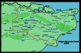
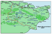 The East Malling Stream, known locally as "The Stream", rises at Well Street, East Malling, Kent, and flows in a generally easterly direction to join the River Medway
River Medway
The River Medway, which is almost entirely in Kent, England, flows for from just inside the West Sussex border to the point where it enters the Thames Estuary....
at Mill Hall, Aylesford
Aylesford
Aylesford is a village and civil parish on the River Medway in Kent, 4 miles NW of Maidstone in England.Originally a small riverside settlement, the old village comprises around 60 houses, many of which were formerly shops. One pub, a Post Office and four small independent shops remain...
. It powered six watermills. The stream may have formerly been known as the Bradbourne, Bradbourne Lane in Ditton
Ditton, Kent
Ditton is a large village and civil parish in the Tonbridge and Malling District of Kent, England. The village is about north-west of Maidstone town centre and east of West Malling. The parish, which is long and narrow, straddles the A20 , with farmland to the south and industry to the north...
bearing witness to this name.
Watermills
The Domesday BookDomesday Book
Domesday Book , now held at The National Archives, Kew, Richmond upon Thames in South West London, is the record of the great survey of much of England and parts of Wales completed in 1086...
recorded two mills worth 10/- at Metlinge (East Malling). In 1363 there were two mills in the village. East Malling possessed a fulling mill from 1567 to 1719, most likely to have been Middle Mill. Thomas Tomlyn was a miller in the 17th century, Thomas Pidgeon, corn miller of East Malling died in 1685, In 1706 there were three mills - Upper, Weir and Middle Mills. The history of the paper mill
Paper mill
A paper mill is a factory devoted to making paper from vegetable fibres such as wood pulp, old rags and other ingredients using a Fourdrinier machine or other type of paper machine.- History :...
s needs to be read together, as they were all linked through various owners.
Upper Mill, East Malling.
TQ 697 571 51.287643°N 0.434611°WJames Brooks was the at the mill in 1752, when the mill was rated at £61, increasing to £122 in 1757. By 1764 the mill was operating as a paper
Paper
Paper is a thin material mainly used for writing upon, printing upon, drawing or for packaging. It is produced by pressing together moist fibers, typically cellulose pulp derived from wood, rags or grasses, and drying them into flexible sheets....
mill, James Brooks insuring the mill for £150 in that year. One of his apprentices was Nicholas Tapsfield, who was later to work at the paper mill at Sundridge
River Darent
The River Darent or River Darenth is a Kentish tributary of the River Thames in England. Its name is believed to be from a Celtic word meaning 'river where oak-trees grow'...
. In 1801 he insured the mill for £350 and died in 1805 aged 69. John Larking took the mill 1n 1806, it being then rated at £131. Larking went into partnership with John Morrice by 1816 and Morrice was recorded as being at the mill from 1817-21. He was succeeded by William Blunden, who was working at Upper Mill in 1819, followed by Robert Tassell c.1823. The mill underwent considerable development between 1840 and 1860. It was demolished in the years between the First and Second World Wars. An illustration of Upper Mill can be seen here.
The mill pond was some 200 yards (182.9 m) long, and covered an area of just over ½ acre in 1840. The mill had an overshot waterwheel of some 10 feet (3.05 m) diameter and 8 feet (2.44 m) wide, the remains of which were on site in 1972. The tail race discharged into the mill pond of Weir Mill.
Weir Mill, East Malling.
Probably one of the two Domesday mills. The mill was marked on a map of 1706. The next known mention of Wier Mill was in 1810 when the mill was marked on the map accompanying the enclosure award. In 1840 James Phillips was the owner-occupier of the mill, which was a water corn mill
Gristmill
The terms gristmill or grist mill can refer either to a building in which grain is ground into flour, or to the grinding mechanism itself.- Early history :...
with 12 feet (3.66 m) waterwheel driving two pairs of stones
Millstone
Millstones or mill stones are used in windmills and watermills, including tide mills, for grinding wheat or other grains.The type of stone most suitable for making millstones is a siliceous rock called burrstone , an open-textured, porous but tough, fine-grained sandstone, or a silicified,...
. The pond of Weir Mill is roughly square in shape and covers an area of just over ¼ acre
Acre
The acre is a unit of area in a number of different systems, including the imperial and U.S. customary systems. The most commonly used acres today are the international acre and, in the United States, the survey acre. The most common use of the acre is to measure tracts of land.The acre is related...
. The mill passed from James to Thomas Phillips c.1855 and to Mr. T J Dewe c,1893. G E Hide was working the mill in 1905 and S R Anscombe bought the mill in 1913. The mill last ground corn in 1930 and was bought by Whitbread
Whitbread
Whitbread PLC is a global hotel, coffee shop and restaurant company headquartered in Dunstable, United Kingdom. Its largest division is Premier Inn, which is the largest hotel brand in the UK with around 580 hotels and over 40,000 rooms. Its Costa Coffee chain has around 1,600 stores across 25...
Ltd., the Maidstone
Maidstone
Maidstone is the county town of Kent, England, south-east of London. The River Medway runs through the centre of the town linking Maidstone to Rochester and the Thames Estuary. Historically, the river was a source and route for much of the town's trade. Maidstone was the centre of the agricultural...
brewers, who used part of the mill to store hops
Hops
Hops are the female flower clusters , of a hop species, Humulus lupulus. They are used primarily as a flavoring and stability agent in beer, to which they impart a bitter, tangy flavor, though hops are also used for various purposes in other beverages and herbal medicine...
. The mill subsequently passed into the ownership of Wm. Lillico & Son and was then used as a general store. During this time the timber part of the mill buildings were becoming derelict.
The surviving mill building
The timber clad original mill building dates from the reign of Queen Anne
Anne of Great Britain
Anne ascended the thrones of England, Scotland and Ireland on 8 March 1702. On 1 May 1707, under the Act of Union, two of her realms, England and Scotland, were united as a single sovereign state, the Kingdom of Great Britain.Anne's Catholic father, James II and VII, was deposed during the...
. A brick extension was added in two stages, the last part being built in 1889. Roller mills of 4½ sack capacity were installed c.1893 as was a boiler
Boiler
A boiler is a closed vessel in which water or other fluid is heated. The heated or vaporized fluid exits the boiler for use in various processes or heating applications.-Materials:...
and steam engine
Steam engine
A steam engine is a heat engine that performs mechanical work using steam as its working fluid.Steam engines are external combustion engines, where the working fluid is separate from the combustion products. Non-combustion heat sources such as solar power, nuclear power or geothermal energy may be...
, principally to drive the roller mills whilst the waterwheel drove the stones. The steam engine was a beam engine, it was eventually sold to a buyer in the USA.
The wooden mill
This is four storeys in height, the base being of brick and the upper storeys timber. The 12 feet (3.66 m) diameter waterwheel was overshot with eighty buckets and carried on a 9 inches (228.6 mm) diameter cast iron axle. The wooden upright shaft was only 6 inches (152.4 mm) diameter, reducing to 4 inches (101.6 mm) at first floor level. It carried a Great Spur Wheel and an iron Crown Wheel of 6 feet (1.83 m) diameter. This received a drive from the steam engine so that the mill could be driven that way if necessary. The mill drove three pairs of millstones.
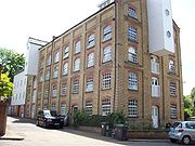
The brick mill
This was built in two parts, latterly known as the "middle room" and the "end room", this last part being built in 1889. The mill was some six storeys in height, dwarfing the original mill. The middle room contained the roller mills, six in total.
Middle Mill, East Malling.
TQ 696 574 51.290369°N 0.433321°WProbably one of the two Domesday mills. Middle Mill was in existence in 1684 when the pond was shown on a map drawn by Abraham Walter. In 1755 Richard Gowlett was the papermaker here, and in that year he took John Evernden and Elizabeth Sands as apprentices. He insured the mill for £35 in 1770 and he died c.1778, his widow Mary paying the rates on the mill until 1798 when the mill was sold to George Blunden. William Blunden was at the mill in 1816, but George Blunden was again recorded at the mill in 1824. He was recorded at a manufacturer of brown and white paper in 1832 and Francis Collins joined him in partnership that year. Robert Tassell acquired the mill c.1833 and went into partnership with Henry Smith in 1838. In 1841 there was an increase in the rateable value of the property from £54 to £150. The partnership was dissolved in 1848, all three mills being in the sole ownership of Robert Tassell from 1834 to 1838. The mill stood empty from 1848 to 1850, when the Busbridge brothers took over the running of the mills. They were involved in a Court case in 1859 over the discharge of foul water used in the paper making process. The mill pond covered an area of just over one-half acre. An illustration of Middle Mill can be seen here.
Lower Mill, East Malling.
TQ 697 576 51.292136°N 0.434849°WIn 1792 Clement and George Taylor were granted a patent for the use of chlorine for bleaching rags for use in paper manufacture. James Whatman claimed that he wa able to prove that several trials had already been made, including by Mr. Larking, who owned Lower Mill at that time. In 1816, John Larking and John Morrice were in partnership at both Upper and Lower Mills, the partnership being dissolved on 8 October of that year, John Morrice taking both mills. Robert Tassell took both mills by 1821, making both brown and white papers. He went into partnership with Henry Smith in 1838 and by 1844 they owned all three paper mills. This partnership was dissolved c.1844 and Henry Smith was the sole occupier of the three mills, worth together £420. In 1848 Lower Mill was recorded as empty and valued at £120. All three mills were managed by Thomas Harris Busbridge and George Frederick Busbridge from c.1849. It is likely that Lower Mill ceased regular production of paper in 1848, being used spasmodically until 1851, and closing completely by 1852. The mill seems to have been demolished by 1860, not appearing on the first 25 inch Ordnance Survey map. The mill pond is some 200 yards (182.9 m) long and 50 yards (45.7 m) wide, covering an area of just under 1½ acres (6,100 m²).
Church Mills, Ditton.
TQ 709 582 51.297168°N 0.452332°WA Domesday site, one mill was recorded at Dictvne (Ditton
Ditton, Kent
Ditton is a large village and civil parish in the Tonbridge and Malling District of Kent, England. The village is about north-west of Maidstone town centre and east of West Malling. The parish, which is long and narrow, straddles the A20 , with farmland to the south and industry to the north...
) with a value of 10/-. Tenants of this corn mill include Edward Smith in 1724, J Whiteing from 1725–43, Thomas Shepard 1744-54, his widow in 1755-6, William Luck in 1757. Thomas Allchin was at the mill in 1840 and was still there in 1852. Joseph Jellis was the miller in 1887-90 and Robert Foster was the last known miller in 1905. The mill closed down c.1912. The mill is located close to the ford
Ford (crossing)
A ford is a shallow place with good footing where a river or stream may be crossed by wading or in a vehicle. A ford is mostly a natural phenomenon, in contrast to a low water crossing, which is an artificial bridge that allows crossing a river or stream when water is low.The names of many towns...
in Bradbourne Lane. In its later years the waterwheel was replaced by a turbine
Water turbine
A water turbine is a rotary engine that takes energy from moving water.Water turbines were developed in the 19th century and were widely used for industrial power prior to electrical grids. Now they are mostly used for electric power generation. They harness a clean and renewable energy...
.
Mill Hall Mill, Aylesford.
TQ 715 589 51.303276°N 0.461267°WThis mill was marked on a map of 1684, it was a paper mill at that time. In 1695 Edward Middleton was working the mill, which then had a rateable value of £20. He was at the mill until 1724 when William Harris took it over. William Harris died in 1741 and his widow ran the mill until 1744 when Thomas Harris took it over. He was still at the mill in 1763 when he insured the mill for £100. in 1776 Thomas Golding insured the mill. He was still at the mill in 1803 but by 1812 his son Stephen Golding was recorded as a master paper maker of Ditton when he married. There was a partnership between Thomas Golding and his sons Stephen and Thomas jr which was dissolved in 1816. The artist Jean Claude Natteas (1785–1822) sketched the mill in 1816. In 1832, Robert Tassell took over the mill and it ceased to make paper by 1841. In 1841, Stephen Spratt was recorded as the occupier of the mill, by then a corn mill. he was at the mill until at least 1862. In the 1871 census the miller was Henry Stonham who lived there with his wife Rebecca and brother Charles, also a miller. However in the 1881 census brother Charles is shown as the miller living there with his wife and family. In 1878 the owner is still Charles Stoham and sons. A steam engine was recorded at the mill in 1887, but had gone by 1890, when Walter Skinner was the miller, still there in 1895. Henry Packham was the last miller, there at least 1905-13, but the mill had stopped working by 1922. The machinery was removed and the building converted into stables by A E Reed & Co. Ltd. the mill was demolished c.1950 but the waterwheel survived until 1969.
The mill was of three storeys, the base being of ragstone and the upper storeys of timber, clad in tarred weatherboarding
Weatherboarding
Weatherboarding is the cladding or ‘siding’ of a house consisting of long thin timber boards that overlap one another, either vertically or horizontally on the outside of the wall. They are usually of rectangular section with parallel sides...
. The overshot waterwheel was 14 feet (4.27 m) diameter and 6 feet (1.83 m) wide, mounted on a 9 inches (228.6 mm) square iron axle, driving an iron pit wheel. The iron pentrough was dated 1887. The final remains of Mill Hall Mill were demolished to make way for the foundations of a footbridge over the M20
M20 motorway
The M20 is a motorway in Kent, England. It runs from the M25 motorway to Folkestone, providing a link to the Channel Tunnel and the ports at Dover. It is long...
.
Ford
TQ 708 579 51.294502°N 0.450755°W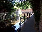
Ford (crossing)
A ford is a shallow place with good footing where a river or stream may be crossed by wading or in a vehicle. A ford is mostly a natural phenomenon, in contrast to a low water crossing, which is an artificial bridge that allows crossing a river or stream when water is low.The names of many towns...
on Bradbourne Lane. In recent years Kent County Council
Kent County Council
Kent County Council is the county council that governs the majority of the county of Kent in England. It provides the upper tier of local government, below which are 12 district councils, and around 300 town and parish councils. The county council has 84 elected councillors...
have attempted to close the road through the ford without going through the correct legal channels.