

Decca Navigator System
Encyclopedia

Low frequency
Low frequency or low freq or LF refers to radio frequencies in the range of 30 kHz–300 kHz. In Europe, and parts of Northern Africa and of Asia, part of the LF spectrum is used for AM broadcasting as the longwave band. In the western hemisphere, its main use is for aircraft beacon,...
hyperbolic navigation
Hyperbolic navigation
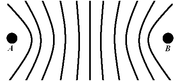
Hyperbolic navigation refers to a class of radio navigation systems based on the difference in timing between the reception of two signals, without reference to a common clock. Calculating the distance from the stations based on these timings produces a series of hyperbolic lines...
system (also known as multilateration
Multilateration
Multilateration is a navigation technique based on the measurement of the difference in distance to two or more stations at known locations that broadcast signals at known times. Unlike measurements of absolute distance or angle, measuring the difference in distance results in an infinite number of...
) that was first deployed during World War II
World War II
World War II, or the Second World War , was a global conflict lasting from 1939 to 1945, involving most of the world's nations—including all of the great powers—eventually forming two opposing military alliances: the Allies and the Axis...
when the Allied forces needed a system which could be used to achieve accurate landings. As was the case with Loran C, its primary use was for ship navigation in coastal waters.
Fishing vessels were major post-war users, but it was also used on aircraft, including a very early (1949) application of moving-map displays. The system was deployed extensively in the North Sea
North Sea
In the southwest, beyond the Straits of Dover, the North Sea becomes the English Channel connecting to the Atlantic Ocean. In the east, it connects to the Baltic Sea via the Skagerrak and Kattegat, narrow straits that separate Denmark from Norway and Sweden respectively...
and was used by helicopters operating to oil platform
Oil platform
An oil platform, also referred to as an offshore platform or, somewhat incorrectly, oil rig, is a lаrge structure with facilities to drill wells, to extract and process oil and natural gas, and to temporarily store product until it can be brought to shore for refining and marketing...
s. After being shut down in the spring of 2000, it has been superseded by systems such as the American GPS
Global Positioning System
The Global Positioning System is a space-based global navigation satellite system that provides location and time information in all weather, anywhere on or near the Earth, where there is an unobstructed line of sight to four or more GPS satellites...
and the planned European GALILEO positioning system
Galileo positioning system
Galileo is a global navigation satellite system currently being built by the European Union and European Space Agency . The €20 billion project is named after the famous Italian astronomer Galileo Galilei...
.
It was deployed in the United Kingdom
United Kingdom
The United Kingdom of Great Britain and Northern IrelandIn the United Kingdom and Dependencies, other languages have been officially recognised as legitimate autochthonous languages under the European Charter for Regional or Minority Languages...
after World War II and later used in many areas around the world. Decca employees used to joke that DECCA was an acronym for Dedicated Englishmen Causing Chaos Abroad.
Overview
Master station
In telecommunication, the term master station has the following meanings:1. In a data network, the station that is designated by the control station to ensure data transfer to one or more slave stations....
and three (occasionally two) Slave stations, termed Red, Green and Purple. Ideally, the Slaves would be positioned at the vertices of an equilateral triangle with the Master at the centre. The baseline length, that is, the Master-Slave distance, was typically 60~120 nautical miles. Each station transmitted a continuous wave signal that, by comparing the phase
Phase (waves)
Phase in waves is the fraction of a wave cycle which has elapsed relative to an arbitrary point.-Formula:The phase of an oscillation or wave refers to a sinusoidal function such as the following:...
difference of the signals from the Master and one of the Slaves, resulted in a set of hyperbolic lines of position called a pattern. As there were three Slaves there were three patterns, termed Red, Green and Purple. The patterns were drawn on nautical charts as a set of hyperbolic lines in the appropriate colour. Receivers identified which hyperbola
Hyperbola
In mathematics a hyperbola is a curve, specifically a smooth curve that lies in a plane, which can be defined either by its geometric properties or by the kinds of equations for which it is the solution set. A hyperbola has two pieces, called connected components or branches, which are mirror...
they were on and a position could be plotted at the intersection of the hyperbola
Hyperbola
In mathematics a hyperbola is a curve, specifically a smooth curve that lies in a plane, which can be defined either by its geometric properties or by the kinds of equations for which it is the solution set. A hyperbola has two pieces, called connected components or branches, which are mirror...
from different patterns, usually by using the pair with the angle of cut closest to orthogonal as possible.
Detailed Principles of Operation
When two stations transmit at the same phase-locked frequencyPhase-locked loop
A phase-locked loop or phase lock loop is a control system that generates an output signal whose phase is related to the phase of an input "reference" signal. It is an electronic circuit consisting of a variable frequency oscillator and a phase detector...
, the difference in phase between the two signals is constant along a hyperbolic path. Of course, if two stations transmit on the same frequency, it is practically impossible for the receiver to separate them; so instead of all stations transmitting at the same frequency, each chain was allocated a nominal frequency, 1f, and each station in the chain transmitted at a harmonic of this base frequency, as follows:
| Station | Harmonic | Frequency (kHz) |
|---|---|---|
| Master | 6f | 85.000 |
| Purple Slave | 5f | 70.833 |
| Red Slave | 8f | 113.333 |
| Green Slave | 9f | 127.500 |
The frequencies given are those for Chain 5B, known as the English Chain, but all chains used similar frequencies between 70 kHz and 129 kHz.
Decca receivers multiplied the signals received from the Master and each Slave by different values to arrive at a common frequency (least common multiple
Least common multiple
In arithmetic and number theory, the least common multiple of two integers a and b, usually denoted by LCM, is the smallest positive integer that is a multiple of both a and b...
, LCM) for each Master/Slave pair, as follows:
| Pattern | Slave Harmonic | Slave Multiplier | Master Harmonic | Master Multiplier | Common Frequency |
|---|---|---|---|---|---|
| Purple | 5f | ×6 | 6f | ×5 | 30f |
| Red | 8f | ×3 | 6f | ×4 | 24f |
| Green | 9f | ×2 | 6f | ×3 | 18f |
It was phase comparison at this common frequency that resulted in the hyperbolic lines of position. The interval between two adjacent hyperbolas on which the signals are in phase was called a lane. Since the wavelength of the common frequency was small compared with the distance between the Master and Slave stations there were many possible lines of position for a given phase difference, and so a unique position could not be arrived at by this method.
Other receivers, typically for aeronautical applications, divided the transmitted frequencies down to the basic frequency (1f) for phase comparison, rather than multiplying them up to the LCM frequency.
Lanes and Zones
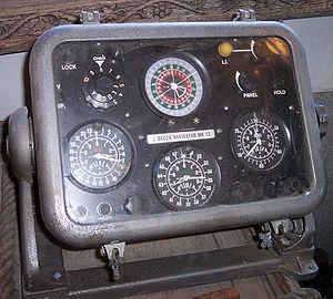
Early Decca receivers were fitted with three rotating Decometers that indicated the phase difference for each pattern. Each Decometer drove a second indicator that counted the number of lanes traversed – each 360 degrees of phase difference was one lane traversed. In this way, assuming the point of departure was known, a more or less distinct location could be identified.The lanes were grouped into zones, with 18 green, 24 red, or 30 purple lanes in each zone. This meant that on the baseline (the straight line between the Master and its Slave) the zone width was the same for all three patterns of a given chain. Typical lane and zone widths on the baseline are shown in the table below (for chain 5B):
| Lane or Zone | Width on Baseline |
|---|---|
| Purple lane | 352.1 m |
| Red lane | 440.1 m |
| Green lane | 586.8 m |
| Zones (all patterns) | 10563 m |
The lanes were numbered 0 to 23 for red, 30 to 47 for green and 50 to 79 for purple. The zones were labelled A to J, repeating after J. A Decca position coordinate could thus be written: Red I 16.30; Green D 35.80. Later receivers incorporated a microprocessor and displayed a position in latitude and longitude.
Multipulse
Multipulse provided an automatic method of lane and zone identification by using the same phase comparison techniques described above on lower frequency signals.The nominally continuous wave transmissions were in fact divided into a 20 second cycle, with each station in turn simultaneously transmitting all four Decca frequencies (5f, 6f, 8f and 9f) in a phase-coherent relationship for a brief period of 0.45 seconds each cycle. This transmission, known as Multipulse, allowed the receiver to extract the 1f frequency and so to identify which lane the receiver was in (to a resolution of a zone).
As well as transmitting the Decca frequencies of 5f, 6f, 8f and 9f, an 8.2f signal, known as Orange, was also transmitted. The beat frequency between the 8.0f (Red) and 8.2f (Orange) signals allowed a 0.2f signal to be derived and so resulted in a hyperbolic pattern in which one cycle (360°) of phase difference equates to 5 zones.
Assuming that one’s position was known to this accuracy, this gave an effectively unique position.
Range and Accuracy
During daylight ranges of around 400 nautical miles (740.8 km) could be obtained, reducing at night to 200 to 250 nautical miles (463 km), depending on propagation conditions.The accuracy depended on:
- Width of the lanes
- Angle of cut of the hyperbolic lines of position
- Instrumental errors
- Propagation errors (for example, SkywaveSkywaveSkywave is the propagation of electromagnetic waves bent back to the Earth's surface by the ionosphere. As a result of skywave propagation, a broadcast signal from a distant AM broadcasting station at night, or from a shortwave radio station can sometimes be heard as clearly as local...
)
By day these errors could range from a few meters on the baseline up to a nautical mile at the edge of coverage. At night, skywave errors were greater and on receivers without multipulse capabilities it was not unusual for the position to jump a lane, sometimes without the navigator knowing.
Although in the days of differential GPS
Global Positioning System
The Global Positioning System is a space-based global navigation satellite system that provides location and time information in all weather, anywhere on or near the Earth, where there is an unobstructed line of sight to four or more GPS satellites...
this range and accuracy may appear poor, in its day the Decca system was one of the few, if not the only, position fixing system available to many mariners. Since the need for an accurate position is less when the vessel is further from land, the reduced accuracy at long ranges was not a great problem.
Origins
In 1936 William J. O'Brien, an American engineer, contracted tuberculosis which put his career on hold for a period of two years. During this period he had the idea of position fixing by means of phase comparison of continuous wave transmissions. The initial market envisaged was for aircraft and some experiments were carried out in California in 1938. However both the American Army and Navy considered the idea too complicated.O’Brien had a friend, Harvey F. Schwarz, who was chief engineer of the Decca Record company
Decca Records
Decca Records began as a British record label established in 1929 by Edward Lewis. Its U.S. label was established in late 1934; however, owing to World War II, the link with the British company was broken for several decades....
in England, and in 1939 sent him details of the system so it could be put forward to the British military. Initially Robert Watson-Watt
Robert Watson-Watt
Sir Robert Alexander Watson-Watt, KCB, FRS, FRAeS is considered by many to be the "inventor of radar". Development of radar, initially nameless, was first started elsewhere but greatly expanded on 1 September 1936 when Watson-Watt became...
reviewed the system but he did not follow it up. However, in October 1941 the British Admiralty Signal Establishment (ASE) became interested in the system, which was then classified as Admiralty Outfit QM. O’Brien came over to the UK and conducted the first marine trials between Anglesey
Anglesey
Anglesey , also known by its Welsh name Ynys Môn , is an island and, as Isle of Anglesey, a county off the north west coast of Wales...
and the Isle of Man
Isle of Man
The Isle of Man , otherwise known simply as Mann , is a self-governing British Crown Dependency, located in the Irish Sea between the islands of Great Britain and Ireland, within the British Isles. The head of state is Queen Elizabeth II, who holds the title of Lord of Mann. The Lord of Mann is...
, at frequencies of 305/610 kHz, on 16 September 1942. These were successful and further trials were conducted in the northern Irish Sea
Irish Sea
The Irish Sea separates the islands of Ireland and Great Britain. It is connected to the Celtic Sea in the south by St George's Channel, and to the Atlantic Ocean in the north by the North Channel. Anglesey is the largest island within the Irish Sea, followed by the Isle of Man...
in April 1943 at 70/130 kHz. A three-station trial was held in conjunction with a large-scale assault and landing exercise in the Moray Firth
Moray Firth
The Moray Firth is a roughly triangular inlet of the North Sea, north and east of Inverness, which is in the Highland council area of north of Scotland...
in February/March 1944.
The success of the trials and the relative ease of use and accuracy of the system resulted in Decca receiving an order for 27 Admiralty Outfit QM receivers. The receiver consisted of an electronics unit with two dials and was known to its operators as the "Blue Gasmeter Job". A Decca chain was set up, consisting of a master station at Chichester
Chichester
Chichester is a cathedral city in West Sussex, within the historic County of Sussex, South-East England. It has a long history as a settlement; its Roman past and its subsequent importance in Anglo-Saxon times are only its beginnings...
and slaves at Swanage
Swanage
Swanage is a coastal town and civil parish in the south east of Dorset, England. It is situated at the eastern end of the Isle of Purbeck, approximately 10 km south of Poole and 40 km east of Dorchester. The parish has a population of 10,124 . Nearby are Ballard Down and Old Harry Rocks,...
and Beachy Head
Beachy Head
Beachy Head is a chalk headland on the south coast of England, close to the town of Eastbourne in the county of East Sussex, immediately east of the Seven Sisters. The cliff there is the highest chalk sea cliff in Britain, rising to 162 m above sea level. The peak allows views of the south...
. A fourth, decoy, transmitter was located in the Thames Estuary
Thames Estuary
The Thames Mouth is the estuary in which the River Thames meets the waters of the North Sea.It is not easy to define the limits of the estuary, although physically the head of Sea Reach, near Canvey Island on the Essex shore is probably the western boundary...
as part of the deception that the invasion would be focussed on the Calais
Calais
Calais is a town in Northern France in the department of Pas-de-Calais, of which it is a sub-prefecture. Although Calais is by far the largest city in Pas-de-Calais, the department's capital is its third-largest city of Arras....
area.
21 minesweepers and other vessels were fitted with Admiralty Outfit QM and on 5 June 1944 they used it to accurately navigate across the English Channel
English Channel
The English Channel , often referred to simply as the Channel, is an arm of the Atlantic Ocean that separates southern England from northern France, and joins the North Sea to the Atlantic. It is about long and varies in width from at its widest to in the Strait of Dover...
and to sweep the minefields in the planned areas. The swept areas were marked with buoys in preparation for the Normandy Landings.
After the initial ship tests, Decca conducted tests in cars, driving in the Kingston By-Pass area to verify receiver accuracy. In the car installation, it was found possible to navigate within an individual traffic lane. The company entertained high hopes that the system could be used in aircraft, to permit much more precise navigation in the critical airspace around airports and urban centers where traffic density was highest.
Deployment
After the end of World War IIWorld War II
World War II, or the Second World War , was a global conflict lasting from 1939 to 1945, involving most of the world's nations—including all of the great powers—eventually forming two opposing military alliances: the Allies and the Axis...
the Decca Navigator Co. Ltd. was formed (1945) and the system expanded rapidly, particularly in areas of British influence; at its peak it was deployed in many of the world's major shipping areas. More than 15,000 receiving sets were in use aboard ships in 1970. There were 4 chains around England
England
England is a country that is part of the United Kingdom. It shares land borders with Scotland to the north and Wales to the west; the Irish Sea is to the north west, the Celtic Sea to the south west, with the North Sea to the east and the English Channel to the south separating it from continental...
, 1 in Ireland
Ireland
Ireland is an island to the northwest of continental Europe. It is the third-largest island in Europe and the twentieth-largest island on Earth...
and 2 in Scotland
Scotland
Scotland is a country that is part of the United Kingdom. Occupying the northern third of the island of Great Britain, it shares a border with England to the south and is bounded by the North Sea to the east, the Atlantic Ocean to the north and west, and the North Channel and Irish Sea to the...
, 12 in Scandinavia
Scandinavia
Scandinavia is a cultural, historical and ethno-linguistic region in northern Europe that includes the three kingdoms of Denmark, Norway and Sweden, characterized by their common ethno-cultural heritage and language. Modern Norway and Sweden proper are situated on the Scandinavian Peninsula,...
(5 each in Norway
Norway
Norway , officially the Kingdom of Norway, is a Nordic unitary constitutional monarchy whose territory comprises the western portion of the Scandinavian Peninsula, Jan Mayen, and the Arctic archipelago of Svalbard and Bouvet Island. Norway has a total area of and a population of about 4.9 million...
and Sweden
Sweden
Sweden , officially the Kingdom of Sweden , is a Nordic country on the Scandinavian Peninsula in Northern Europe. Sweden borders with Norway and Finland and is connected to Denmark by a bridge-tunnel across the Öresund....
and 1 each in Denmark
Denmark
Denmark is a Scandinavian country in Northern Europe. The countries of Denmark and Greenland, as well as the Faroe Islands, constitute the Kingdom of Denmark . It is the southernmost of the Nordic countries, southwest of Sweden and south of Norway, and bordered to the south by Germany. Denmark...
and Finland
Finland
Finland , officially the Republic of Finland, is a Nordic country situated in the Fennoscandian region of Northern Europe. It is bordered by Sweden in the west, Norway in the north and Russia in the east, while Estonia lies to its south across the Gulf of Finland.Around 5.4 million people reside...
), a further 4 elsewhere in northern Europe
Europe
Europe is, by convention, one of the world's seven continents. Comprising the westernmost peninsula of Eurasia, Europe is generally 'divided' from Asia to its east by the watershed divides of the Ural and Caucasus Mountains, the Ural River, the Caspian and Black Seas, and the waterways connecting...
and 2 in Spain
Spain
Spain , officially the Kingdom of Spain languages]] under the European Charter for Regional or Minority Languages. In each of these, Spain's official name is as follows:;;;;;;), is a country and member state of the European Union located in southwestern Europe on the Iberian Peninsula...
.
In the late 1950s an experimental Decca chain was set up in the United States
United States
The United States of America is a federal constitutional republic comprising fifty states and a federal district...
, in the New York area, to be used for navigating the Vertol 107 helicopters of New York Airways. These helicopters were operating from the principal local airports—John F. Kennedy Airport on Long Island, Newark Airport in New Jersey, LaGuardia Airport in the Borough of Queens, nearer to Manhattan, and a site on the top of the (then) PanAm Building
MetLife Building
The MetLife Building, originally called the Pan Am Building, is a skyscraper located at 200 Park Avenue in Midtown Manhattan, New York City.-History:...
on Park Avenue. Use of Decca was essential because its signals could be received down to sea level, were not subject to the line-of-sight limitations of VOR
VHF omnidirectional range
VOR, short for VHF omnidirectional radio range, is a type of radio navigation system for aircraft. A VOR ground station broadcasts a VHF radio composite signal including the station's identifier, voice , and navigation signal. The identifier is typically a two- or three-letter string in Morse code...
/DME
Distance Measuring Equipment
Distance measuring equipment is a transponder-based radio navigation technology that measures distance by timing the propagation delay of VHF or UHF radio signals....
and did not suffer the slant-range errors that create problems with VOR/DME close to the transmitters. The Decca installations in the New York Airways helicopters included the unique Decca 'roller map' displays that enabled the pilot to see his or her position at a glance, a concept infeasible with VOR/DME. This chain installation was considered highly controversial at the time, for political reasons. This led to the U.S. Coast Guard, under instructions from the Treasury Department to which it reported, banning the use of Decca receivers in ships entering New York harbor for fear that the system might create a de facto standard (as it had become in other areas of the world). It also served to protect the marketing interests of the Hoffman Electronics division of ITT, a principal supplier of VOR/DME systems, that Decca might have been poised to usurp.
This situation was exacerbated by the workload problems of the Air Traffic Controllers Association (ATCA), under its executive director Francis McDermott, whose members were forced to use radar data on aircraft positions, relaying those positions by radio to the aircraft from their control locations. An example of the problem, cited by experts, was the collision of a Boeing 707 and a Lockheed Constellation over Staten Island, New York, that—according to some experts—could have been avoided if the aircraft had been Decca equipped and could not only have determined their positions more precisely but would not have suffered from the rho-theta position errors inherent in VOR/DME.
Other chains were established in Japan
Japan
Japan is an island nation in East Asia. Located in the Pacific Ocean, it lies to the east of the Sea of Japan, China, North Korea, South Korea and Russia, stretching from the Sea of Okhotsk in the north to the East China Sea and Taiwan in the south...
(6 chains); Namibia
Namibia
Namibia, officially the Republic of Namibia , is a country in southern Africa whose western border is the Atlantic Ocean. It shares land borders with Angola and Zambia to the north, Botswana to the east and South Africa to the south and east. It gained independence from South Africa on 21 March...
and South Africa
South Africa
The Republic of South Africa is a country in southern Africa. Located at the southern tip of Africa, it is divided into nine provinces, with of coastline on the Atlantic and Indian oceans...
(5 chains); India
India
India , officially the Republic of India , is a country in South Asia. It is the seventh-largest country by geographical area, the second-most populous country with over 1.2 billion people, and the most populous democracy in the world...
and Bangladesh
Bangladesh
Bangladesh , officially the People's Republic of Bangladesh is a sovereign state located in South Asia. It is bordered by India on all sides except for a small border with Burma to the far southeast and by the Bay of Bengal to the south...
(4 chains); Canada
Canada
Canada is a North American country consisting of ten provinces and three territories. Located in the northern part of the continent, it extends from the Atlantic Ocean in the east to the Pacific Ocean in the west, and northward into the Arctic Ocean...
(4 chains around Newfoundland
Newfoundland and Labrador
Newfoundland and Labrador is the easternmost province of Canada. Situated in the country's Atlantic region, it incorporates the island of Newfoundland and mainland Labrador with a combined area of . As of April 2011, the province's estimated population is 508,400...
and Nova Scotia
Nova Scotia
Nova Scotia is one of Canada's three Maritime provinces and is the most populous province in Atlantic Canada. The name of the province is Latin for "New Scotland," but "Nova Scotia" is the recognized, English-language name of the province. The provincial capital is Halifax. Nova Scotia is the...
); North-West Australia
Australia
Australia , officially the Commonwealth of Australia, is a country in the Southern Hemisphere comprising the mainland of the Australian continent, the island of Tasmania, and numerous smaller islands in the Indian and Pacific Oceans. It is the world's sixth-largest country by total area...
(2 chains); the Persian Gulf
Persian Gulf
The Persian Gulf, in Southwest Asia, is an extension of the Indian Ocean located between Iran and the Arabian Peninsula.The Persian Gulf was the focus of the 1980–1988 Iran-Iraq War, in which each side attacked the other's oil tankers...
(1 chain with stations in Qatar
Qatar
Qatar , also known as the State of Qatar or locally Dawlat Qaṭar, is a sovereign Arab state, located in the Middle East, occupying the small Qatar Peninsula on the northeasterly coast of the much larger Arabian Peninsula. Its sole land border is with Saudi Arabia to the south, with the rest of its...
and the United Arab Emirates
United Arab Emirates
The United Arab Emirates, abbreviated as the UAE, or shortened to "the Emirates", is a state situated in the southeast of the Arabian Peninsula in Western Asia on the Persian Gulf, bordering Oman, and Saudi Arabia, and sharing sea borders with Iraq, Kuwait, Bahrain, Qatar, and Iran.The UAE is a...
and a second chain in the north of the Gulf with stations in Iran
Iran
Iran , officially the Islamic Republic of Iran , is a country in Southern and Western Asia. The name "Iran" has been in use natively since the Sassanian era and came into use internationally in 1935, before which the country was known to the Western world as Persia...
) and the Bahamas (1 chain). Four chains were planned for Nigeria
Nigeria
Nigeria , officially the Federal Republic of Nigeria, is a federal constitutional republic comprising 36 states and its Federal Capital Territory, Abuja. The country is located in West Africa and shares land borders with the Republic of Benin in the west, Chad and Cameroon in the east, and Niger in...
but only 2 chains were built and these did not enter into public service. Two chains in Vietnam
Vietnam
Vietnam – sometimes spelled Viet Nam , officially the Socialist Republic of Vietnam – is the easternmost country on the Indochina Peninsula in Southeast Asia. It is bordered by China to the north, Laos to the northwest, Cambodia to the southwest, and the South China Sea –...
were used during the Vietnam War
Vietnam War
The Vietnam War was a Cold War-era military conflict that occurred in Vietnam, Laos, and Cambodia from 1 November 1955 to the fall of Saigon on 30 April 1975. This war followed the First Indochina War and was fought between North Vietnam, supported by its communist allies, and the government of...
for helicopter navigation, with limited success.
During the Cold War period, following WWII, the R.A.F. established a confidential chain in Germany. The Master station was in Bad Iburg
Bad Iburg
Bad Iburg is a town in the district of Osnabrück, in Lower Saxony, Germany. It is situated in the Teutoburg Forest, 16 km south of Osnabrück....
near Osnabrück and there were two Slaves. The purpose of this chain was to provide accurate air navigation for the corridor between Western Germany and Berlin in the event that a mass evacuation of allied personnel may be required. In order to maintain secrecy, frequencies were changed at irregular intervals.
Decca, Racal, and the closedown
Decca Navigator was headquartered at New Malden, Surrey, just off the Kingston by-pass. There was a Decca School, at BrixhamBrixham
Brixham is a small fishing town and civil parish in the county of Devon, in the south-west of England. Brixham is at the southern end of Torbay, across the bay from Torquay, and is a fishing port. Fishing and tourism are its major industries. At the time of the 2001 census it had a population of...
, Devon
Devon
Devon is a large county in southwestern England. The county is sometimes referred to as Devonshire, although the term is rarely used inside the county itself as the county has never been officially "shired", it often indicates a traditional or historical context.The county shares borders with...
, where employees were sent on courses from time to time.
Racal
Racal
Racal Electronics plc was once the third-largest British electronics firm. Listed on the London Stock Exchange and once a constituent of the FTSE 100 Index, Racal was a diversified company, offering products including: as voice and data recorders; point of sale terminals; laboratory instruments;...
, the UK weapons and communications company, acquired Decca in 1980. Claiming the acquisition was to acquire Decca's radar company, rather than the avionics side of the business, it sold off parts including Decca Navigator.
The monopoly
Monopoly
A monopoly exists when a specific person or enterprise is the only supplier of a particular commodity...
on leased, not purchased, receivers by Decca generated great wealth for the company. This monopoly was later broken in the early 1980s when receivers could be purchased by users, thereby reducing the cost following the lapse of the patent on the basic system technology.
A Danish company started manufacturing receivers for fishing boats which employed Decca's navigation charts, but users didn't pay rental for using the system.
In the ensuing court battle Decca lost the monopoly, and that signalled the beginning of the end. Income dwindled and eventually, the UK Ministry of Transport
Department for Transport
In the United Kingdom, the Department for Transport is the government department responsible for the English transport network and a limited number of transport matters in Scotland, Wales and Northern Ireland which are not devolved...
stepped in, having the lighthouse authorities
Trinity House
The Corporation of Trinity House of Deptford Strond is the official General Lighthouse Authority for England, Wales and other British territorial waters...
take responsibility for operating the system in the early 1990s.
A ruling from the European Union
European Union
The European Union is an economic and political union of 27 independent member states which are located primarily in Europe. The EU traces its origins from the European Coal and Steel Community and the European Economic Community , formed by six countries in 1958...
forced the UK government to withdraw funding - for fishermen users - and started the process which eventually resulted in the system being closed down and the installations scrapped.
The Decca Navigator System provided by the General Lighthouse Authorities ceased to operate at midnight on 31 March 2000. The Irish chain provided by Bórd Iascaigh Mhara
Bord Iascaigh Mhara
Bord Iascaigh Mhara or BIM is the agency of the Irish State with responsibility for developing the Irish marine fishing and aquaculture industries....
continued transmitting until 19 May 2000.
Japan holds the distinction of being the last bastion of Decca having closed down the Hokkaidō
Hokkaido
, formerly known as Ezo, Yezo, Yeso, or Yesso, is Japan's second largest island; it is also the largest and northernmost of Japan's 47 prefectural-level subdivisions. The Tsugaru Strait separates Hokkaido from Honshu, although the two islands are connected by the underwater railway Seikan Tunnel...
chain (9C) in March 2001. This was one year later than the UK closure. Hokkaidō was also the first Decca chain to open in Japan in the year 1967.
Other Applications
A more accurate system named Hi-Fix was developed using signalling in the 1.6 MHz range. It was used for specialised applications such as precision measurements involved with oil-drilling and by the Royal Navy for detailed mapping and surveying of coasts and harbours. The Hi-Fix equipment was leased for a period with temporary chains established to provide coverage of the area required, Hi-Fix was commercialised by Racal Survey in the early 1980s. An experimental chain was installed with coverage of central London and receivers placed in London buses and other vehicles to demonstrate an early vehicle location and tracking system. Each vehicle would report its location automatically via a conventional VHF two-way radio link, the data added to a voice channel. A forerunner to a system employed by London black cabs in the 1990s using GPS and now the widespread use of GSM, 3G and Wi-Fi geolocation applications.An interesting characteristic of the Decca VLF signal discovered on BOAC, later British Airways, test flights to Moscow, was that the carrier switching could not be detected even though the carrier could be received with sufficient strength to provide navigation. Such testing, involving civilian aircraft, is quite common and may well not be in the knowledge of a pilot.
The 'low frequency' signalling of the Decca system also permitted its use on submarines. One 'enhancement' of the Decca system was to offer the potential of keying the signal, using Morse code, to signal the onset of nuclear war. This was never optioned by the UK government. Messages were clandestinely sent, however, between Decca stations thereby bypassing international telephone calls, especially in non-UK chains.
A long range trans North Atlantic system was in operation from the mid 1950's. It was called DECTRA. It utilised two stations in Newfoundland and two in Scotland. The transmissions used normal "pattern" transmitters of a much higher power than on standard DECCA frequencies. It was intended as an air navigational aid.
See also
- GEE (navigation)GEE (navigation)Gee was the code name given to a radio navigation system used by the Royal Air Force during World War II.Different sources record the name as GEE or Gee. The naming supposedly comes from "Grid", so the lower case form is more correct, and is the form used in Drippy's publications. See Drippy 1946....
- Loran-C
- Omega (navigation system)
- Local positioning system