

Cypress Hills
Encyclopedia
The Cypress Hills are a region of hills
in southwestern Saskatchewan
and southeastern Alberta
, Canada
.
The highest point in Saskatchewan at 1468 m (4,816 ft) is located at Lookout Point in the Cypress Hills.
–English
dictionary
written by C. M. Lanning provided the Blackfoot
name I-kim-e-kooy, which translates as Striped Earth or Earth over Earth. The Cree
name, in use at the same time, was Manâtakâw, (spelled in a variety of anglicized forms including "Mun-a-tuh-gow"), sometimes said to mean Beautiful Upland but more accurately referring to "an area to be respected, protected, taken care of and/or taken care with". Early Métis
hunters, who spoke a variation of French
, called the hills les montagnes des Cyprès, in reference to the abundance of pine
trees. To the Métis, most evergreen trees were easily labelled cyprès, but the region has no true cypress trees. The English translation is Cypress Hills.
s but are rather the remnants of erosion of a Tertiary
plateau
of sediment
formed during the initial uplift of the Rocky Mountains
. This uplift caused the plain above which the hills now rise to be elevated, with the result that river
s flowing to the north and south eroded most of the softer sediments onto the lower part of the Great Plains
. Today, the Cypress Hills form a major drainage
divide separating rivers draining to the Gulf of Mexico
(via the Missouri River
) from those draining to Hudson Bay
and James Bay
via the Nelson River
; thus the Cypress Hills form a water divide
. There is a ranch northwest of Eastend, Saskatchewan
, called Dividing Springs Ranch; the water from this spring goes both south to Gulf of Mexico and north to Hudson Bay.
Because they formed a suture zone between the Laurentide
and Cordilleran
ice sheet
s, the Cypress Hills are the northernmost point in North America
that remained south of the continental ice sheets during the Wisconsin glaciation
. In fact, along with northern Yukon
, Banks Island
, some nunatak
s (e.g. on the Gaspé Peninsula
and western Newfoundland) and possibly the Brooks Peninsula, the hills and their southern slopes are the only unglaciated land in present-day Canada. This gives them an appearance very different from the typical "alpine" mountains of most of Canada, with a flat top and steep sides. This suggests that during a very severe glaciation of the Pre-Illinoian Stage the hills would have become a true nunatak
, like the serpentinite
hills of Gros Morne National Park
, Newfoundland
.
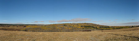
The undulating terrain comes from a series of morainal ridges composed of glacial till deposited when a glacier paused during its retreat 15,000 years ago.
 The hills, because of the higher precipitation
they receive, support extensive forest
and also some rare fescue
grassland
. Most of the flora is shared with the mountains in states such as Montana
and Wyoming
rather than with the rest of Canada.
and First Nations
peoples including the Cree
, Assiniboine, Atsina, Blackfoot
, Saulteaux
, Sioux
, Crow
, and others. During the 19th century Métis settled in the hills, hunting and often wintering there. The Cypress Hills Massacre
, a key event in Canadian history leading to the creation of the North-West Mounted Police occurred in the hills when a group of American wolvers from Montana massacred an Assiniboine encampment. Fort Walsh
was established to bring law and order to the Canadian border region.
.
The Alberta portion of the Cypress Hills contains the tourist destination of Elkwater
, a community with campground facilities located on the southern shore of Elkwater Lake
. The townsite is mainly made up of summer cabins. Elkwater is located about 70 km southeast of Medicine Hat
.
Mountain
Image:Himalaya_annotated.jpg|thumb|right|The Himalayan mountain range with Mount Everestrect 58 14 160 49 Chomo Lonzorect 200 28 335 52 Makalurect 378 24 566 45 Mount Everestrect 188 581 920 656 Tibetan Plateaurect 250 406 340 427 Rong River...
in southwestern Saskatchewan
Saskatchewan
Saskatchewan is a prairie province in Canada, which has an area of . Saskatchewan is bordered on the west by Alberta, on the north by the Northwest Territories, on the east by Manitoba, and on the south by the U.S. states of Montana and North Dakota....
and southeastern Alberta
Alberta
Alberta is a province of Canada. It had an estimated population of 3.7 million in 2010 making it the most populous of Canada's three prairie provinces...
, Canada
Canada
Canada is a North American country consisting of ten provinces and three territories. Located in the northern part of the continent, it extends from the Atlantic Ocean in the east to the Pacific Ocean in the west, and northward into the Arctic Ocean...
.
The highest point in Saskatchewan at 1468 m (4,816 ft) is located at Lookout Point in the Cypress Hills.
Name
The Cypress Hills have been known by a wide number of native and European names throughout their history. An 1882 BlackfootBlackfoot
The Blackfoot Confederacy or Niitsítapi is the collective name of three First Nations in Alberta and one Native American tribe in Montana....
–English
English language
English is a West Germanic language that arose in the Anglo-Saxon kingdoms of England and spread into what was to become south-east Scotland under the influence of the Anglian medieval kingdom of Northumbria...
dictionary
Dictionary
A dictionary is a collection of words in one or more specific languages, often listed alphabetically, with usage information, definitions, etymologies, phonetics, pronunciations, and other information; or a book of words in one language with their equivalents in another, also known as a lexicon...
written by C. M. Lanning provided the Blackfoot
Blackfoot
The Blackfoot Confederacy or Niitsítapi is the collective name of three First Nations in Alberta and one Native American tribe in Montana....
name I-kim-e-kooy, which translates as Striped Earth or Earth over Earth. The Cree
Cree
The Cree are one of the largest groups of First Nations / Native Americans in North America, with 200,000 members living in Canada. In Canada, the major proportion of Cree live north and west of Lake Superior, in Ontario, Manitoba, Saskatchewan, Alberta and the Northwest Territories, although...
name, in use at the same time, was Manâtakâw, (spelled in a variety of anglicized forms including "Mun-a-tuh-gow"), sometimes said to mean Beautiful Upland but more accurately referring to "an area to be respected, protected, taken care of and/or taken care with". Early Métis
Métis people (Canada)
The Métis are one of the Aboriginal peoples in Canada who trace their descent to mixed First Nations parentage. The term was historically a catch-all describing the offspring of any such union, but within generations the culture syncretised into what is today a distinct aboriginal group, with...
hunters, who spoke a variation of French
Canadian French
Canadian French is an umbrella term referring to the varieties of French spoken in Canada. French is the mother tongue of nearly seven million Canadians, a figure constituting roughly 22% of the national population. At the federal level it has co-official status alongside English...
, called the hills les montagnes des Cyprès, in reference to the abundance of pine
Pine
Pines are trees in the genus Pinus ,in the family Pinaceae. They make up the monotypic subfamily Pinoideae. There are about 115 species of pine, although different authorities accept between 105 and 125 species.-Etymology:...
trees. To the Métis, most evergreen trees were easily labelled cyprès, but the region has no true cypress trees. The English translation is Cypress Hills.
Geology
The hills are not true mountainMountain
Image:Himalaya_annotated.jpg|thumb|right|The Himalayan mountain range with Mount Everestrect 58 14 160 49 Chomo Lonzorect 200 28 335 52 Makalurect 378 24 566 45 Mount Everestrect 188 581 920 656 Tibetan Plateaurect 250 406 340 427 Rong River...
s but are rather the remnants of erosion of a Tertiary
Tertiary
The Tertiary is a deprecated term for a geologic period 65 million to 2.6 million years ago. The Tertiary covered the time span between the superseded Secondary period and the Quaternary...
plateau
Plateau
In geology and earth science, a plateau , also called a high plain or tableland, is an area of highland, usually consisting of relatively flat terrain. A highly eroded plateau is called a dissected plateau...
of sediment
Sediment
Sediment is naturally occurring material that is broken down by processes of weathering and erosion, and is subsequently transported by the action of fluids such as wind, water, or ice, and/or by the force of gravity acting on the particle itself....
formed during the initial uplift of the Rocky Mountains
Rocky Mountains
The Rocky Mountains are a major mountain range in western North America. The Rocky Mountains stretch more than from the northernmost part of British Columbia, in western Canada, to New Mexico, in the southwestern United States...
. This uplift caused the plain above which the hills now rise to be elevated, with the result that river
River
A river is a natural watercourse, usually freshwater, flowing towards an ocean, a lake, a sea, or another river. In a few cases, a river simply flows into the ground or dries up completely before reaching another body of water. Small rivers may also be called by several other names, including...
s flowing to the north and south eroded most of the softer sediments onto the lower part of the Great Plains
Great Plains
The Great Plains are a broad expanse of flat land, much of it covered in prairie, steppe and grassland, which lies west of the Mississippi River and east of the Rocky Mountains in the United States and Canada. This area covers parts of the U.S...
. Today, the Cypress Hills form a major drainage
Drainage
Drainage is the natural or artificial removal of surface and sub-surface water from an area. Many agricultural soils need drainage to improve production or to manage water supplies.-Early history:...
divide separating rivers draining to the Gulf of Mexico
Gulf of Mexico
The Gulf of Mexico is a partially landlocked ocean basin largely surrounded by the North American continent and the island of Cuba. It is bounded on the northeast, north and northwest by the Gulf Coast of the United States, on the southwest and south by Mexico, and on the southeast by Cuba. In...
(via the Missouri River
Missouri River
The Missouri River flows through the central United States, and is a tributary of the Mississippi River. It is the longest river in North America and drains the third largest area, though only the thirteenth largest by discharge. The Missouri's watershed encompasses most of the American Great...
) from those draining to Hudson Bay
Hudson Bay
Hudson Bay , sometimes called Hudson's Bay, is a large body of saltwater in northeastern Canada. It drains a very large area, about , that includes parts of Ontario, Quebec, Saskatchewan, Alberta, most of Manitoba, southeastern Nunavut, as well as parts of North Dakota, South Dakota, Minnesota,...
and James Bay
James Bay
James Bay is a large body of water on the southern end of Hudson Bay in Canada. Both bodies of water extend from the Arctic Ocean. James Bay borders the provinces of Quebec and Ontario; islands within the bay are part of Nunavut...
via the Nelson River
Nelson River
The Nelson River is a river of north-central North America, in the Canadian province of Manitoba. Its full length is , it has mean discharge of , and has a drainage basin of , of which is in the United States...
; thus the Cypress Hills form a water divide
Water divide
A drainage divide, water divide, divide or watershed is the line separating neighbouring drainage basins...
. There is a ranch northwest of Eastend, Saskatchewan
Eastend, Saskatchewan
-Infrastructure:The Saskatchewan Transportation Company provides intercity passenger and parcel express service to Eastend.-Attractions:Local Attractions:...
, called Dividing Springs Ranch; the water from this spring goes both south to Gulf of Mexico and north to Hudson Bay.
Because they formed a suture zone between the Laurentide
Laurentide ice sheet
The Laurentide Ice Sheet was a massive sheet of ice that covered hundreds of thousands of square miles, including most of Canada and a large portion of the northern United States, multiple times during Quaternary glacial epochs. It last covered most of northern North America between c. 95,000 and...
and Cordilleran
Cordilleran Ice Sheet
The Cordilleran ice sheet was a major ice sheet that covered, during glacial periods of the Quaternary, a large area of North America. This included the following areas:*Western Montana*The Idaho Panhandle...
ice sheet
Ice sheet
An ice sheet is a mass of glacier ice that covers surrounding terrain and is greater than 50,000 km² , thus also known as continental glacier...
s, the Cypress Hills are the northernmost point in North America
North America
North America is a continent wholly within the Northern Hemisphere and almost wholly within the Western Hemisphere. It is also considered a northern subcontinent of the Americas...
that remained south of the continental ice sheets during the Wisconsin glaciation
Wisconsin glaciation
The last glacial period was the most recent glacial period within the current ice age occurring during the last years of the Pleistocene, from approximately 110,000 to 10,000 years ago....
. In fact, along with northern Yukon
Yukon
Yukon is the westernmost and smallest of Canada's three federal territories. It was named after the Yukon River. The word Yukon means "Great River" in Gwich’in....
, Banks Island
Banks Island
One of the larger members of the Canadian Arctic Archipelago, Banks Island is situated in the Inuvik Region of the Northwest Territories, Canada. It is separated from Victoria Island to its east by the Prince of Wales Strait and from the mainland by Amundsen Gulf to its south. The Beaufort Sea lies...
, some nunatak
Nunatak
A nunatak is an exposed, often rocky element of a ridge, mountain, or peak not covered with ice or snow within an ice field or glacier. The term is typically used in areas where a permanent ice sheet is present...
s (e.g. on the Gaspé Peninsula
Gaspé Peninsula
The Gaspésie , or Gaspé Peninsula or the Gaspé, is a peninsula along the south shore of the Saint Lawrence River in Quebec, Canada, extending into the Gulf of Saint Lawrence...
and western Newfoundland) and possibly the Brooks Peninsula, the hills and their southern slopes are the only unglaciated land in present-day Canada. This gives them an appearance very different from the typical "alpine" mountains of most of Canada, with a flat top and steep sides. This suggests that during a very severe glaciation of the Pre-Illinoian Stage the hills would have become a true nunatak
Nunatak
A nunatak is an exposed, often rocky element of a ridge, mountain, or peak not covered with ice or snow within an ice field or glacier. The term is typically used in areas where a permanent ice sheet is present...
, like the serpentinite
Serpentinite
Serpentinite is a rock composed of one or more serpentine group minerals. Minerals in this group are formed by serpentinization, a hydration and metamorphic transformation of ultramafic rock from the Earth's mantle...
hills of Gros Morne National Park
Gros Morne National Park
Gros Morne National Park is a world heritage site located on the west coast of Newfoundland. At , it is the second largest national park in Atlantic Canada ....
, Newfoundland
Newfoundland and Labrador
Newfoundland and Labrador is the easternmost province of Canada. Situated in the country's Atlantic region, it incorporates the island of Newfoundland and mainland Labrador with a combined area of . As of April 2011, the province's estimated population is 508,400...
.
The undulating terrain comes from a series of morainal ridges composed of glacial till deposited when a glacier paused during its retreat 15,000 years ago.
Ecology
Precipitation (meteorology)
In meteorology, precipitation In meteorology, precipitation In meteorology, precipitation (also known as one of the classes of hydrometeors, which are atmospheric water phenomena is any product of the condensation of atmospheric water vapor that falls under gravity. The main forms of precipitation...
they receive, support extensive forest
Forest
A forest, also referred to as a wood or the woods, is an area with a high density of trees. As with cities, depending where you are in the world, what is considered a forest may vary significantly in size and have various classification according to how and what of the forest is composed...
and also some rare fescue
Fescue
Festuce is a genus of about 300 species of perennial tufted grasses, belonging to the grass family Poaceae . The genus has a cosmopolitan distribution, although the majority of the species are found in cool temperate areas...
grassland
Grassland
Grasslands are areas where the vegetation is dominated by grasses and other herbaceous plants . However, sedge and rush families can also be found. Grasslands occur naturally on all continents except Antarctica...
. Most of the flora is shared with the mountains in states such as Montana
Montana
Montana is a state in the Western United States. The western third of Montana contains numerous mountain ranges. Smaller, "island ranges" are found in the central third of the state, for a total of 77 named ranges of the Rocky Mountains. This geographical fact is reflected in the state's name,...
and Wyoming
Wyoming
Wyoming is a state in the mountain region of the Western United States. The western two thirds of the state is covered mostly with the mountain ranges and rangelands in the foothills of the Eastern Rocky Mountains, while the eastern third of the state is high elevation prairie known as the High...
rather than with the rest of Canada.
History
Historically the Cypress Hills were a meeting and conflict area for various American IndianNative Americans in the United States
Native Americans in the United States are the indigenous peoples in North America within the boundaries of the present-day continental United States, parts of Alaska, and the island state of Hawaii. They are composed of numerous, distinct tribes, states, and ethnic groups, many of which survive as...
and First Nations
First Nations
First Nations is a term that collectively refers to various Aboriginal peoples in Canada who are neither Inuit nor Métis. There are currently over 630 recognised First Nations governments or bands spread across Canada, roughly half of which are in the provinces of Ontario and British Columbia. The...
peoples including the Cree
Cree
The Cree are one of the largest groups of First Nations / Native Americans in North America, with 200,000 members living in Canada. In Canada, the major proportion of Cree live north and west of Lake Superior, in Ontario, Manitoba, Saskatchewan, Alberta and the Northwest Territories, although...
, Assiniboine, Atsina, Blackfoot
Blackfoot
The Blackfoot Confederacy or Niitsítapi is the collective name of three First Nations in Alberta and one Native American tribe in Montana....
, Saulteaux
Saulteaux
The Saulteaux are a First Nation in Ontario, Manitoba, Saskatchewan, Alberta and British Columbia, Canada.-Ethnic classification:The Saulteaux are a branch of the Ojibwe nations. They are sometimes also called Anihšināpē . Saulteaux is a French term meaning "people of the rapids," referring to...
, Sioux
Sioux
The Sioux are Native American and First Nations people in North America. The term can refer to any ethnic group within the Great Sioux Nation or any of the nation's many language dialects...
, Crow
Crow Nation
The Crow, also called the Absaroka or Apsáalooke, are a Siouan people of Native Americans who historically lived in the Yellowstone River valley, which extends from present-day Wyoming, through Montana and into North Dakota. They now live on a reservation south of Billings, Montana and in several...
, and others. During the 19th century Métis settled in the hills, hunting and often wintering there. The Cypress Hills Massacre
Cypress Hills massacre
The Cypress Hills massacre occurred on June 1, 1873, in the Cypress Hills region of Battle Creek, North-West Territories , involving a group of American Bison hunters, American wolf hunters or 'wolfers', American and Canadian whiskey traders, Métis cargo haulers or 'freighters', and a camp of...
, a key event in Canadian history leading to the creation of the North-West Mounted Police occurred in the hills when a group of American wolvers from Montana massacred an Assiniboine encampment. Fort Walsh
Fort Walsh
Fort Walsh is a National Historic Site of Canada that was a North-West Mounted Police fort and the site of the Cypress Hills Massacre. Administered by Parks Canada, it forms a constituent part of Cypress Hills Interprovincial Park....
was established to bring law and order to the Canadian border region.
Interprovincial park
The Cypress Hills Provincial Park was established in 1951 in this area, and it was extended into Saskatchewan in 1989, as Cypress Hills Interprovincial ParkCypress Hills Interprovincial Park
Cypress Hills Interprovincial Park is an interprovincial park straddling the southern Alberta-Saskatchewan border, located southeast of Medicine Hat...
.
The Alberta portion of the Cypress Hills contains the tourist destination of Elkwater
Elkwater, Alberta
-External links:*...
, a community with campground facilities located on the southern shore of Elkwater Lake
Elkwater Lake (Alberta)
Elkwater Lake is a small lake in southeastern Alberta, Canada.It is located in the northwest corner of the Cypress Hills Interprovincial Park, along the Buffalo Trail...
. The townsite is mainly made up of summer cabins. Elkwater is located about 70 km southeast of Medicine Hat
Medicine Hat, Alberta
Medicine Hat, known to locals as "The Hat", is a city of 61,097 people located in the southeastern part of the province of Alberta, Canada. It is enclaved within Cypress County along with the nearby Town of Redcliff, although neither is part of the county....
.
Climate
See also
- Black HillsBlack HillsThe Black Hills are a small, isolated mountain range rising from the Great Plains of North America in western South Dakota and extending into Wyoming, USA. Set off from the main body of the Rocky Mountains, the region is something of a geological anomaly—accurately described as an "island of...
- a similar landform in the United States. - List of highest points of Canadian provinces and territories