
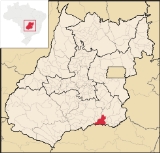
Corumbaíba
Encyclopedia
| Corumbaíba | |
|---|---|
| State | Goiás Goiás Goiás is a state of Brazil, located in the central part of the country. The name Goiás comes from the name of an indigenous community... |
| Coordinates: | 18°08′50"S 48°33′01"W |
| Area: | 1.881.7 km² (10/10/2002) |
| Population: | 8,001 (IBGE 2007) |
| Elevation: | 633m above sea level |
| Postcode (CEP): | 75680-000 |
| IBGE statistical microregion: | 017 Catalão Microregion Catalão Microregion The Catalão Microregion is a statistical microregion created by IBGE in south-eastern Goiás state, Brazil.*Population: 131.741 inhabitants *Cities: 11*Total Area: 15,238.60 km²... |
| Became a city: | 1905 |
| Mayor: | Denismar Carneiro de Araújo (2005–2009) |
| Distance to Goiânia Goiânia -Climate:The city has a tropical wet and dry climate with an average temperature of . There's a wet season, from October to April, and a dry one, from May to September. Annual rainfall is around 1,520 mm.... : |
222 km. |
| Website: | none |
Town
A town is a human settlement larger than a village but smaller than a city. The size a settlement must be in order to be called a "town" varies considerably in different parts of the world, so that, for example, many American "small towns" seem to British people to be no more than villages, while...
and municipality
Municipality
A municipality is essentially an urban administrative division having corporate status and usually powers of self-government. It can also be used to mean the governing body of a municipality. A municipality is a general-purpose administrative subdivision, as opposed to a special-purpose district...
in southeastern Goiás
Goiás
Goiás is a state of Brazil, located in the central part of the country. The name Goiás comes from the name of an indigenous community...
state, Brazil
Brazil
Brazil , officially the Federative Republic of Brazil , is the largest country in South America. It is the world's fifth largest country, both by geographical area and by population with over 192 million people...
.
Location and Connections
Corumbaíba is located 222 kilometers from the state capital, GoiâniaGoiânia
-Climate:The city has a tropical wet and dry climate with an average temperature of . There's a wet season, from October to April, and a dry one, from May to September. Annual rainfall is around 1,520 mm....
. It is south of Caldas Novas
Caldas Novas
Caldas Novas is a Brazilian city and municipality in the state of Goiás. It is considered by many to be the largest hydro-thermal resort in the world.-Location:...
and north of the Itumbiara reservoir.
Connections from Goiânia
Goiânia
-Climate:The city has a tropical wet and dry climate with an average temperature of . There's a wet season, from October to April, and a dry one, from May to September. Annual rainfall is around 1,520 mm....
are made by BR-352 / Bela Vista de Goiás
Bela Vista de Goiás
Bela Vista de Goiás is a small city located in central Goiás state in Brazil.-Location:It is 45 kilometers from the state capital of Goiânia...
/ GO-147 / Piracanjuba
Piracanjuba
Piracanjuba is a small city and municipality in southeastern Goiás state, Brazil. It is a big producer of orchids, milk products, and soybeans. Piracanjuba is also the name of a fish common to the waters of the Plata River basin....
/ GO-217 / GO-139 / Caldas Novas
Caldas Novas
Caldas Novas is a Brazilian city and municipality in the state of Goiás. It is considered by many to be the largest hydro-thermal resort in the world.-Location:...
/ Marzagão
Marzagão
Marzagão is a small town and municipality in south Goiás state, Brazil.-Location:Marzagão is located in the Meia Ponte Microregion in the extreme south of the state, less than 100 kilometers north of the great Itumbiara reservoir, which forms the boundary with the state of Minas Gerais...
.
It has boundaries with the following municipalities:
- north: IpameriIpameriIpameri is a small city and municipality in southeastern Goiás state, in Brazil. The population was 23,114 in a total area of 4,368.6 km² . It is a major producer of soybeans, corn, and livestock.-Location and connections:...
and Caldas NovasCaldas NovasCaldas Novas is a Brazilian city and municipality in the state of Goiás. It is considered by many to be the largest hydro-thermal resort in the world.-Location:...
; - south: AraguariAraguariAraguari is a city and municipality in northwestern Minas Gerais state, Brazil. It is located in the northern Triângulo Mineiro region, on the Jordão River, a tributary of the Paranaíba River, at an elevation between 940 and 1,087 meters....
and TupaciguaraTupaciguaraTupaciguara is a Brazilian municipality located in the west of the state of Minas Gerais. Its population as of 2007 was 23,076 living in a total area of 1,826 km². The city belongs to the statistical mesoregion of Triângulo Mineiro and Alto Paranaíba and to the statistical microregion of...
; - east: Nova AuroraNova Aurora, GoiásNova Aurora is a small town and municipality in south Goiás state, Brazil.-Location:Nova Aurora is located about fifty kilometers north of the Paranaíba River, which forms the boundary between the states of Goiás and Minas Gerais. It is part of the Catalão Microregion and is 32 kilometers west of...
, CumariCumariCumari is a small town and municipality in southeast Goiás state, Brazil. The population was 3,055 in a total area of 579.8 km².-Connections and Municipal boundaries:Cumari is 304 kilometers from the state capital, Goiânia...
, AnhangüeraAnhangüeraAnhangüera originates from a word in the Tupi language which was the nickname given by Brazilian Indians to an explorer and "bandeirante", Bartolomeu Bueno da Silva .It may also refer to:* Anhanguera, Goiás, a municipality in the state of Goiás...
and GoiandiraGoiandiraGoiandira is a small town and municipality in the southeastern portion of the Brazilian state of Goiás. The population was 4,925 in a total area of 560.7 km² .-Geography:...
; - west: Buriti AlegreBuriti AlegreBuriti Alegre is a small town and municipality in south Goiás state, Brazil. The population was 8,287 inhabitants in a total area of 897.4 km². Buriti Alegre is a large producer of poultry products.-Location and communications:...
, Água LimpaÁgua LimpaÁgua Limpa is a small town and municipality in south Goiás state, Brazil. The population was 2365 in 2005 and the municipal area was 454.3 km².Geographical Information...
and MarzagãoMarzagãoMarzagão is a small town and municipality in south Goiás state, Brazil.-Location:Marzagão is located in the Meia Ponte Microregion in the extreme south of the state, less than 100 kilometers north of the great Itumbiara reservoir, which forms the boundary with the state of Minas Gerais...
.
Demographic and Political Data
- Population density: 4.24 inhab/km² (2007)
- Population growth rate 2000/2007: 2.67.%
- Urban population in 2007: 6,107
- Rural population in 2007: 1,894
- Eligible voters in 2007: 6,263
- City government in 2005:
- Mayor (prefeito): Denismar Carneiro de Araújo
- Vice-mayor (vice-prefeito): Walter das Graças de Deus
- Councilmembers (vereadores): 09
Economy
Corumbaíba has important plantations of riceRice
Rice is the seed of the monocot plants Oryza sativa or Oryza glaberrima . As a cereal grain, it is the most important staple food for a large part of the world's human population, especially in East Asia, Southeast Asia, South Asia, the Middle East, and the West Indies...
, bean
Bean
Bean is a common name for large plant seeds of several genera of the family Fabaceae used for human food or animal feed....
s, corn
Maize
Maize known in many English-speaking countries as corn or mielie/mealie, is a grain domesticated by indigenous peoples in Mesoamerica in prehistoric times. The leafy stalk produces ears which contain seeds called kernels. Though technically a grain, maize kernels are used in cooking as a vegetable...
, and soybean
Soybean
The soybean or soya bean is a species of legume native to East Asia, widely grown for its edible bean which has numerous uses...
s. There is extensive raising of cattle
Cattle
Cattle are the most common type of large domesticated ungulates. They are a prominent modern member of the subfamily Bovinae, are the most widespread species of the genus Bos, and are most commonly classified collectively as Bos primigenius...
for beef and milk. There are small industries producing bricks, cheese
Cheese
Cheese is a generic term for a diverse group of milk-based food products. Cheese is produced throughout the world in wide-ranging flavors, textures, and forms....
, mineral salt, and furniture. The town is well-known for its ceramic
Ceramic
A ceramic is an inorganic, nonmetallic solid prepared by the action of heat and subsequent cooling. Ceramic materials may have a crystalline or partly crystalline structure, or may be amorphous...
vases.
Economic Data
- Industrial units: 09 (2007)
- Retail units: 92 (2007)
- Dairies: Goiásminas Indústria de Laticínios Ltda. (2006)
- Banking establishments: Banco Itaú S.A. - Banco do Brasil S.A. (2007)
- Cooperatives: Cooperativa Agrop. dos Produtores Rurais de Corumbaiba-COOPAC (2006)
Animal Raising and Agricultural Production
- Cattle: 137,600 (2006)
- Cotton, rice, corn, and soybeans (3,850 hectares)
- Modest production of passion fruits, coconut, and hearts of palm
- Number of farms: 656
- Total area: 157,039 ha.
- Area of permanent crops: 165 ha.
- Area of perennial crops: 5,906 ha.
- Area of natural pasture: 113,422 ha.
- Workers dependent on agriculture: 1,470
- Farms with tractors: 152
- Tractors: 205
Health and education
- Infant mortality rate in 2000: 19.95 in 1,000 live births
- Literacy rate in 2000: 90.7%
The health system had one hospital with 28 beds and two health clinics. There were 09 schools with 67 classrooms, 123 teachers, and 2,216 students (2007).
Geography and Tourism
The vegetation is mainly cerradoCerrado
The Cerrado, is a vast tropical savanna ecoregion of Brazil, particularly in the states of Gioas and Minas Gerais...
. There are low mountains: Galgas, Negra, dos Arrependidos and Mula Russa. The soils have phosphate
Phosphate
A phosphate, an inorganic chemical, is a salt of phosphoric acid. In organic chemistry, a phosphate, or organophosphate, is an ester of phosphoric acid. Organic phosphates are important in biochemistry and biogeochemistry or ecology. Inorganic phosphates are mined to obtain phosphorus for use in...
s and manganese
Manganese
Manganese is a chemical element, designated by the symbol Mn. It has the atomic number 25. It is found as a free element in nature , and in many minerals...
.
Three rivers cross the area: the Paranaíba
Paranaíba River
The Paranaíba River is a Brazilian river whose source lies in the state of Minas Gerais in the Mata da Corda mountains, municipality of Rio Paranaíba, at an altitude of 1,148 meters; on the other face of this mountain chain are the sources of the Abaeté river, tributary of the São Francisco River...
, the Corumbá
Corumbá River
The Corumbá River is the most important river in the Central Plateau region of Brazil. Its source is in the Montes de Pireneus, near Pirenópolis, state of Goiás, near the boundary with the Federal District and its length ifs 567 km. It receives the waters of the Descoberto and São Bartolomeu,...
, and the Veríssimo, which have potential for the installation of hydroelectric
Hydroelectricity
Hydroelectricity is the term referring to electricity generated by hydropower; the production of electrical power through the use of the gravitational force of falling or flowing water. It is the most widely used form of renewable energy...
plants. There is a waterfall—Cachoeira do Rio Veríssimo—and the waters of the enormous artificial lake of Itumbiara, formed by the Paranaíba.
History
The history of Corumbaíba has its roots in a legendLegend
A legend is a narrative of human actions that are perceived both by teller and listeners to take place within human history and to possess certain qualities that give the tale verisimilitude...
. According to popular belief there lived a white wolf in the region, called Galga. It used to howl frequently. Whoever saw this wolf would have good luck. Manoel Cândido das Neves, an important rancher in the region, allegedly saw the wolf and, thanking his luck, had a chapel built in the name of Bom Jesus da Cana Verde. The settlement began around this chapel. Manoel Cândido donated a large area for the town to be built. The village was first called Arraial dos Cupins and later Arraial dos Paulistas. In 1909 it was called Vila Corumbaíba, because it was bathed by the Corumbá and the Paranaíba rivers. In 1912 it became a municipality, separating from Catalão
Catalão
Catalão is a small city and municipality located in the south of the state of Goiás, in Brazil. It is a large producer of grains, cattle, and phosphates and has a John Deere and Mitsubishi factory.-Demographics:*Population density: 17.85 inhab/km²...
. Source: Sepin
Ranking on the Municipal Human Development Index
- MHDI: 0.767
- State ranking: 44 (out of 242 municipalities in 2000)
- National ranking: 1,412 (out of 5,507 municipalities in 2000)
(All data is from 2000.)
See also
- List of municipalities in Goiás
- Microregions of Goiás
- Catalão MicroregionCatalão MicroregionThe Catalão Microregion is a statistical microregion created by IBGE in south-eastern Goiás state, Brazil.*Population: 131.741 inhabitants *Cities: 11*Total Area: 15,238.60 km²...