
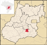
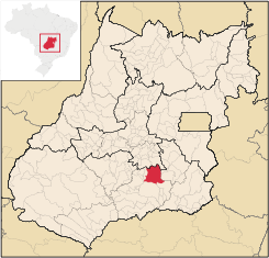
Piracanjuba
Encyclopedia
| Piracanjuba | |
|---|---|
| State | Goiás Goiás Goiás is a state of Brazil, located in the central part of the country. The name Goiás comes from the name of an indigenous community... |
| Coordinates: | |
| Area: | 2,405.1 km² |
| Population: | 23,310 (IBGE 2007) |
| Elevation: | 753m above sea level |
| Postcode (CEP): | 75640-000 |
| IBGE statistical microregion: | Meia Ponte Microregion Meia Ponte Microregion The Meia Ponte Microregion is a statistical region of Goiás state, Brazil created by the IBGE . It is located south of the state capital, Goiânia, and includes 21 cities with a total population of 338,147 inhabitants . The total area is 21,229.00 km² and the population density is 14.39 inhab/km²... |
| Became a city: | 1869 |
| Mayor: | Naudiomar Elias de Souza (Jan 2005-Jan 2009) |
| Distance to Goiânia Goiânia -Climate:The city has a tropical wet and dry climate with an average temperature of . There's a wet season, from October to April, and a dry one, from May to September. Annual rainfall is around 1,520 mm.... : |
85 km. |
| Website: | Prefeitura Municipal de Piracanjuba |
City
A city is a relatively large and permanent settlement. Although there is no agreement on how a city is distinguished from a town within general English language meanings, many cities have a particular administrative, legal, or historical status based on local law.For example, in the U.S...
and municipality
Municipality
A municipality is essentially an urban administrative division having corporate status and usually powers of self-government. It can also be used to mean the governing body of a municipality. A municipality is a general-purpose administrative subdivision, as opposed to a special-purpose district...
in southeastern Goiás state, Brazil
Brazil
Brazil , officially the Federative Republic of Brazil , is the largest country in South America. It is the world's fifth largest country, both by geographical area and by population with over 192 million people...
. It is a big producer of orchids, milk products, and soybeans. Piracanjuba is also the name of a fish (Brycon orbignyanus) common to the waters of the Plata River basin.
Location
Piracanjuba is located southeast of GoiâniaGoiânia
-Climate:The city has a tropical wet and dry climate with an average temperature of . There's a wet season, from October to April, and a dry one, from May to September. Annual rainfall is around 1,520 mm....
. It is in the valley of the Piracanjuba River, which flows to south to join the Paranaíba. The important BR-153 highway lies 23 km. to the west.
Distances to important cities are: Goiânia
Goiânia
-Climate:The city has a tropical wet and dry climate with an average temperature of . There's a wet season, from October to April, and a dry one, from May to September. Annual rainfall is around 1,520 mm....
, 85 km; Morrinhos
Morrinhos
Morrinhos may refer to one of the following cities in Brazil:* Morrinhos, Ceará, a city in the state of Ceará* Morrinhos, Goiás, a city in the state of Goiás* Morrinhos, Rio Grande do Sul, a city in the state of Rio Grande do Sul...
, 76 km;, Caldas Novas
Caldas Novas
Caldas Novas is a Brazilian city and municipality in the state of Goiás. It is considered by many to be the largest hydro-thermal resort in the world.-Location:...
, 62 km; and Brasília
Brasília
Brasília is the capital city of Brazil. The name is commonly spelled Brasilia in English. The city and its District are located in the Central-West region of the country, along a plateau known as Planalto Central. It has a population of about 2,557,000 as of the 2008 IBGE estimate, making it the...
, 282 km. The main highways are Go-413, Go-147, Go-405 and BR-153, the interstate linking Goiânia
Goiânia
-Climate:The city has a tropical wet and dry climate with an average temperature of . There's a wet season, from October to April, and a dry one, from May to September. Annual rainfall is around 1,520 mm....
with the state of Minas Gerais
Minas Gerais
Minas Gerais is one of the 26 states of Brazil, of which it is the second most populous, the third richest, and the fourth largest in area. Minas Gerais is the Brazilian state with the largest number of Presidents of Brazil, the current one, Dilma Rousseff, being one of them. The capital is the...
. There are municipal boundaries with Morrinhos
Morrinhos
Morrinhos may refer to one of the following cities in Brazil:* Morrinhos, Ceará, a city in the state of Ceará* Morrinhos, Goiás, a city in the state of Goiás* Morrinhos, Rio Grande do Sul, a city in the state of Rio Grande do Sul...
, Caldas Novas
Caldas Novas
Caldas Novas is a Brazilian city and municipality in the state of Goiás. It is considered by many to be the largest hydro-thermal resort in the world.-Location:...
, and Professor Jamil
Professor Jamil
Professor Jamil is a small town and municipality in south-central Goiás state, Brazil. The population was 3,298 in a total area of 347.4 km²...
.
History
The origins of Piracanjuba go back to the nineteenth century when Padre Marinho began a settlement called Pouso Alto. A chapel was built in 1831 and by 1833 there were houses in the region. In 1855 it was elevated to district with the name Nossa Senhora da Abadia do Pouso Alto. In 1886 this name was changed to Piracanjuba. In 1907 once again the name was changed to Pouso Alto, only to return to Piracanjuba in 1943. Piracanjuba comes from the name of the river and a fish in the region. Later two districts, CromíniaCromínia
Cromínia is a small town and municipality in south Goiás state, Brazil. It is famous for its chrome mines.-Geographical Information:Cromínia is located in the Meia Ponte Microregion, which includes the cities in the Meia Ponte River basin...
and Mairipotaba
Mairipotaba
Mairipotaba is a small town and municipality, in south Goiás state, Brazil.-Location and Municipal boundaries:Mairipotaba is located in the Meia Ponte Microregion about 85 kilometers directly south of the state capital, Goiânia. It has highway connections with Varjão, 36 kilometers to the north,...
, were dismembered to form separate municipalities.
Origin of the name
The name "Piracanjuba" is derived from the fish with the same name (Triurobrycon lundii), which was once common in river waters of this region. ambientebrasilPolitical Information
- Mayor: Ricardo de Pina Cabral (January 2009)
- City council: 9
- Eligible voters: 18,227 (12/2007)
Demographic Information
- Population density: 9.69 inhab/km² (2007)
- Urban population: 16,752(2007)
- Rural population: 6,558 (2007)
- Population growth or loss: a gain of about 150 people since 1980
Economic Information
The economy is based on agriculture, cattle raising, services, public administration, and small transformation industries. Piracanjuba is considered the state capital of orchids and is one of the largest producers of this flower in BrazilBrazil
Brazil , officially the Federative Republic of Brazil , is the largest country in South America. It is the world's fifth largest country, both by geographical area and by population with over 192 million people...
. Cattle raising, especially for dairy products, is the most important economic activity, but there are also large plantations of soybeans.
- Industrial units: 34 (2007)
- Commercial units: 238 (2007)
- Bank agencies: Banco do Brasil S.A. - BRADESCO S.A. - Banco Itaú S.A.
(June 2005) - CEF
- Dairy: Coop. Agrop. Mista de Piracanjuba Ltda. - Laticínios Bela Vista Ltda. (2007)
- Cattle herd: 199,400 head (2006)
- Poultry: 123,320 (2006)
- Swine: 15,680 (2006)
- Dairy cows: 61,200 (2006)
- Main crops (2006): pineapple, flowers, cotton, rice (3,800 hectares), coffee, beans, sunflowers, oranges, manioc, soybeans (50,500 hectares), tomatoes, and corn (2,150 hectares). Seplan
- Number of agricultural establishments: 1,947
- Agricultural area: 192,516
- Cropland: 36,500 ha.
- Natural pasture: 114,580 ha.
- People working in agriculture: 4,500 IBGE
Education (2006)
- Schools: 30
- Students: 6,800
- Higher education: Faculdade de Piracanjuba - FAP
- Adult literacy rate: 87.7% (2000) (national average was 86.4%) Seplan
Health (2007)
- Hospitals: 2
- Hospital beds: 80 Seplan
- Infant mortality rate: 24.95 (2000) (national average was 33.0).
- MHDI: 0.755
- State ranking: 67 (out of 242 municipalities in 2000)
- National ranking: 1,735 (out of 5,507 municipalities in 2000) For a complete list see Frigoletto.com