

Catalão
Encyclopedia
Catalão is a small city
and municipality
located in the south of the state of Goiás
, in Brazil
. It is a large producer of grains, cattle, and phosphates and has a John Deere and Mitsubishi factory.

which includes 11 cities with a total population of 114,686 inhabitants in an area of 15,238.60 km².
Located in a region of fertile soil rich in phosphates, with excellent highway and railway connections, and watered by several rivers, the municipality has been experiencing rapid growth in recent years and is the third largest payer of state taxes.
The city lies a short distance north of the border with the state of Minas Gerais
where a large dam over the Paranaíba River
, the Barragem de Emborcação
, separates the two states. It is connected by paved highway with Goiânia
(253 km.), Brasília
(330 km.), and Uberlândia
(114), in the rich Mineiro Triangle.
Highway connections with Goiânia
are by BR-352 / Bela Vista de Goiás
/ Cristianópolis
/ GO-020 / BR-352 / Pires do Rio
/ GO-330 / Ipameri
.
Municipal boundaries are with:
Catalão is connected to the East West railroad system and to the future North-South system, which begins in Anápolis. It also has an airport with a runway for small and medium sized planes, 1,400 meters long, paved, and lit at night.
 The municipality is one of the most prosperous in the state. In a study carried out by Seplan of competitivity in municipalities in the state of Goiás
Catalão was ranked third after Anápolis
and Rio Verde
. See Seplan
Catalão got a score of 0.818 on the UN Human Development Index
, ranking it 3 out of 242 municipalities in the state. Nationally it was ranked 253 out of 5,507 municipalities. (All data are from 2000.)
For the complete list see Frigoletto.com
Data are furnished by IBGE
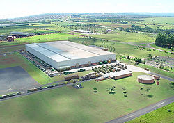
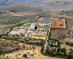
The economic success story of Catalão has been partly attributable to the installation of an industrial park where major enterprises like John Deere (producing sugar cane harvesters) and Mitsubishi, with capacity to produce 27,000 cars a year. This first automobile assembly plant in the Centerwest of Brazil generates 900 direct jobs and approximately 2,700 indirect.
In addition there are three major fertilizer plants, Copebrás, controlled by the Anglo-American group, Fosfértil, and Mineração Catalão De Goiás, which extract phosphate rocks from the subsoil and transform them into fertilizers.
 In the social area the city is showing signs of continuous development. It is already a medical center for the southeast region of Goiás, with several hospitals and specialized clinics.
 Catalão began to be occupied around 1722 or 1723 when one of the bandeirantes
, Bartolomeu Bueno da Silva planted cropos for his supply.
The settlement began around 1728, with the construction of a few huts to support the troops who were penetrating this region. Near Catalão, one of the chaplains of the force, Frei Antônio, a native of Catalunia and called "o Catalão" decided to start a rest point near a small stream.
By 1828, the settlement had five houses with tile roofs and twenty grass covered huts.
In 1859, Catalão became a legally constituted city. Today the municipality has an area of 3,789 km²,. corresponding to 1.1% of the state territory
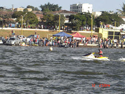
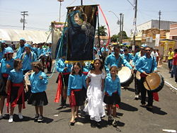
The story of the , Catalão's popular festival began in 1820, when semi-free slaves arrived in the Vila of Catalão to work in the coffee plantations. The slaves brought with them their customs, one of which was the cult of Our Lady of the Rosary
. Her commemoration included a mixture of Afro and Catholic rites. Now these dances, with strong influences from the Congo and Moçambique, are celebrated in Catalão in the largest festival of Congadas in Brazil.
The festival takes place on the last Friday of September and lasts until the second Sunday of October, when the dancers go to the streets in their colorful costumes, filling the city streets with their songs, which give thanks to their patroness for the blessings given.
City
A city is a relatively large and permanent settlement. Although there is no agreement on how a city is distinguished from a town within general English language meanings, many cities have a particular administrative, legal, or historical status based on local law.For example, in the U.S...
and municipality
Municipality
A municipality is essentially an urban administrative division having corporate status and usually powers of self-government. It can also be used to mean the governing body of a municipality. A municipality is a general-purpose administrative subdivision, as opposed to a special-purpose district...
located in the south of the state of Goiás
Goiás
Goiás is a state of Brazil, located in the central part of the country. The name Goiás comes from the name of an indigenous community...
, in Brazil
Brazil
Brazil , officially the Federative Republic of Brazil , is the largest country in South America. It is the world's fifth largest country, both by geographical area and by population with over 192 million people...
. It is a large producer of grains, cattle, and phosphates and has a John Deere and Mitsubishi factory.
Demographics
- Population density: 17.85 inhab/km² (2003)
- Population growth rate 1991/2000: 1.86.%
- Population in 1980: 39,172
- Urban population in 2003: 60,830
- Rural population in 2003: 6,616
Political information
- Eligible voters in 2004: 50,160
- City government in 2005: mayor (Adib Elias Júnior), vice-mayor (João Sebba Neto), and 10 councilmembers
Location and communications
Catalão is the seat of the Catalão MicroregionCatalão Microregion
The Catalão Microregion is a statistical microregion created by IBGE in south-eastern Goiás state, Brazil.*Population: 131.741 inhabitants *Cities: 11*Total Area: 15,238.60 km²...
which includes 11 cities with a total population of 114,686 inhabitants in an area of 15,238.60 km².
Located in a region of fertile soil rich in phosphates, with excellent highway and railway connections, and watered by several rivers, the municipality has been experiencing rapid growth in recent years and is the third largest payer of state taxes.
The city lies a short distance north of the border with the state of Minas Gerais
Minas Gerais
Minas Gerais is one of the 26 states of Brazil, of which it is the second most populous, the third richest, and the fourth largest in area. Minas Gerais is the Brazilian state with the largest number of Presidents of Brazil, the current one, Dilma Rousseff, being one of them. The capital is the...
where a large dam over the Paranaíba River
Paranaíba River
The Paranaíba River is a Brazilian river whose source lies in the state of Minas Gerais in the Mata da Corda mountains, municipality of Rio Paranaíba, at an altitude of 1,148 meters; on the other face of this mountain chain are the sources of the Abaeté river, tributary of the São Francisco River...
, the Barragem de Emborcação
Emborcação Dam
The Emborcação Dam, also known as Theodomiro Sampaio, is an embankment dam on the Paranaíba River near Araguari in Minas Gerais, Brazil. It was constructed for hydroelectric power production and flood control.-Background:...
, separates the two states. It is connected by paved highway with Goiânia
Goiânia
-Climate:The city has a tropical wet and dry climate with an average temperature of . There's a wet season, from October to April, and a dry one, from May to September. Annual rainfall is around 1,520 mm....
(253 km.), Brasília
Brasília
Brasília is the capital city of Brazil. The name is commonly spelled Brasilia in English. The city and its District are located in the Central-West region of the country, along a plateau known as Planalto Central. It has a population of about 2,557,000 as of the 2008 IBGE estimate, making it the...
(330 km.), and Uberlândia
Uberlândia
Uberlândia is the main town in the Triangle region, west of the state of Minas Gerais, Brazil. With a population of 604,013 inhabitants, according to 2010 estimates, the city is the second largest in the state second only to Belo Horizonte...
(114), in the rich Mineiro Triangle.
Highway connections with Goiânia
Goiânia
-Climate:The city has a tropical wet and dry climate with an average temperature of . There's a wet season, from October to April, and a dry one, from May to September. Annual rainfall is around 1,520 mm....
are by BR-352 / Bela Vista de Goiás
Bela Vista de Goiás
Bela Vista de Goiás is a small city located in central Goiás state in Brazil.-Location:It is 45 kilometers from the state capital of Goiânia...
/ Cristianópolis
Cristianópolis
This article is about Cristianópolis, Goiás. For Cristianópolis, Mato Grosso see Cristianópolis, Mato GrossoCristianópolis is a small town and municipality in south-eastern Goiás state, Brazil.-Geographical Information:...
/ GO-020 / BR-352 / Pires do Rio
Pires do Rio
Pires do Rio is a small city and municipality in Goiás state, Brazil. It is a prosperous town and a major producer of poultry.-Location:It is located in the Pires do Rio Microregion. . It is located 144 kilometers from the state capital and is served by highways GO-020, 330 and 414, as well as...
/ GO-330 / Ipameri
Ipameri
Ipameri is a small city and municipality in southeastern Goiás state, in Brazil. The population was 23,114 in a total area of 4,368.6 km² . It is a major producer of soybeans, corn, and livestock.-Location and connections:...
.
Municipal boundaries are with:
- North: Campo Alegre de GoiásCampo Alegre de GoiásCampo Alegre de Goiás is a small town and municipality in southeastern Goiás state, Brazil. It is the largest producer of coffee in the state and an important producer of soybeans, corn, and wheat.-Geography:...
- South: DavinópolisDavinópolisDavinópolis is a small town and municipality in southeastern Goiás state, Brazil. The population was 2,013 in a total area of 520.0 km².-Location and Highway Connections:...
, OuvidorOuvidorOuvidor is a small town and municipality in southeast Goiás state, Brazil.-Location:Located 267 kilometers from the state capital, Goiânia, Ouvidor is connected by BR-352 / Bela Vista de Goiás / Cristianópolis / GO-020 / Pires do Rio / BR-352 / GO-330 / Ipameri / Catalão / GO-330 / BR-352...
, Três RanchosTrês RanchosTrês Ranchos is a small town and municipality in south Goiás state, Brazil.-Location:Três Ranchos is located in the statistical micro-region of Catalão See and is bordered by:*North: Ouvidor*East: Paranaíba River...
, and CumariCumariCumari is a small town and municipality in southeast Goiás state, Brazil. The population was 3,055 in a total area of 579.8 km².-Connections and Municipal boundaries:Cumari is 304 kilometers from the state capital, Goiânia... - East: Minas GeraisMinas GeraisMinas Gerais is one of the 26 states of Brazil, of which it is the second most populous, the third richest, and the fourth largest in area. Minas Gerais is the Brazilian state with the largest number of Presidents of Brazil, the current one, Dilma Rousseff, being one of them. The capital is the...
- West: GoiandiraGoiandiraGoiandira is a small town and municipality in the southeastern portion of the Brazilian state of Goiás. The population was 4,925 in a total area of 560.7 km² .-Geography:...
and IpameriIpameriIpameri is a small city and municipality in southeastern Goiás state, in Brazil. The population was 23,114 in a total area of 4,368.6 km² . It is a major producer of soybeans, corn, and livestock.-Location and connections:...
Catalão is connected to the East West railroad system and to the future North-South system, which begins in Anápolis. It also has an airport with a runway for small and medium sized planes, 1,400 meters long, paved, and lit at night.
Prosperity
Goiás
Goiás is a state of Brazil, located in the central part of the country. The name Goiás comes from the name of an indigenous community...
Catalão was ranked third after Anápolis
Anápolis
Anápolis is the third largest city in the State of Goiás in Brazil. It lies in the center of a rich agricultural region and has become a leader in food processing and pharmaceutical plants.-Location and population:...
and Rio Verde
Rio Verde, Goiás
Rio Verde is a city and municipality in the Brazilian state of Goiás. It is a fast-growing center and is the largest producer of grains in the state.-Location:...
. See Seplan
Catalão got a score of 0.818 on the UN Human Development Index
Human Development Index
The Human Development Index is a composite statistic used to rank countries by level of "human development" and separate "very high human development", "high human development", "medium human development", and "low human development" countries...
, ranking it 3 out of 242 municipalities in the state. Nationally it was ranked 253 out of 5,507 municipalities. (All data are from 2000.)
For the complete list see Frigoletto.com
Economy
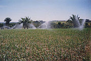
Traditionally a land of cattle raising, Catalão is still a great producer of meat and dairy products (150,000 head of cattle in 2003) and poultry (424,000 head in 2003). There is large production of corn, soybeans, and wheat, with the latest technology of central pivot irrigation being used extensively. Recently the cultivation of garlic has played an important role in the economy.Economic facts in 2005
- Industrial establishments: 193
- Industrial district: Distrito Mínero-Industrial – DIMIC
- Packing houses: Mayor Ind. e Comércio de Carnes Ltda.
- Dairies: Cooperativa Agropecuária de Catalão Ltda
- Banks: 06
- Retail establishments: 912
Main crops in planted area (2003)
- coffee: 5.2 km² / 1,144 tons
- oranges: 1 km² / 2,000 tons
- palmito: 0.2 km² / 60 tons
- garlic: 3 km² / 1,400 tons
- rice: 18 km² / 4,320 tons
- sugarcane: 2 km² / 12,000 tons
- beans: 7 km² / 1,830 tons (three harvests a year)
- corn: 110 km² / 77,000 tons (2 harvests a year)
- soybeans: 650 km² / 238,500 tons
- wheat: 15 km² / 7,500 tons
Data are furnished by IBGE
The economic success story of Catalão has been partly attributable to the installation of an industrial park where major enterprises like John Deere (producing sugar cane harvesters) and Mitsubishi, with capacity to produce 27,000 cars a year. This first automobile assembly plant in the Centerwest of Brazil generates 900 direct jobs and approximately 2,700 indirect.
In addition there are three major fertilizer plants, Copebrás, controlled by the Anglo-American group, Fosfértil, and Mineração Catalão De Goiás, which extract phosphate rocks from the subsoil and transform them into fertilizers.
Motor vehicles
- automobiles and pickup trucks: 15,209 (2004)
- trucks: 1,207
- motorcycles: 5,687
Main economic activities of employment
- agriculture: 383 workers
- extractive industries: 12 with 323 workers
- transformation industries: 267 units with 3,025 workers
- construction: 53 units with 218 workers
- commerce: 1,629 units with 4,553 workers
- hotels and restaurants: 145 units with 477 workers
- transport and storage: 181 units with 712 workers
- public administration: 1,788 workers
Health and education
Health data
- Health establishments (2002): 33 (16 public)
- Hospitals: 04 (02 private)
- Hospital beds: 347 (275 available for public use)
- Public doctors, nurses, and dentists: 132 / 12 / 46
Educational data
- Pre-primary school enrollment and schools (2004) : 2,327 (967 private), 31 (18 private)
- Primary school enrollment and schools: 12,402 (2,835 private), 49 (18 private)
- Middle school enrollment and schools: 3,520 (747 private), 12 (6 private)
- Higher education: 2,864 in one public school (UFG). The Federal University of Goiás has a campus which offers several courses, such as: Computer Science, Physical Education, Geography, History, Maths, Physics, Chemistry, Biology, Superior Studies in Letters, Pedagogy (Education), Psychology and Business Administration.
History and the Festival of Congadas
Bandeirantes
The bandeirantes were composed of Indians , caboclos , and some whites who were the captains of the Bandeiras. Members of the 16th–18th century South American slave-hunting expeditions called bandeiras...
, Bartolomeu Bueno da Silva planted cropos for his supply.
The settlement began around 1728, with the construction of a few huts to support the troops who were penetrating this region. Near Catalão, one of the chaplains of the force, Frei Antônio, a native of Catalunia and called "o Catalão" decided to start a rest point near a small stream.
By 1828, the settlement had five houses with tile roofs and twenty grass covered huts.
In 1859, Catalão became a legally constituted city. Today the municipality has an area of 3,789 km²,. corresponding to 1.1% of the state territory
The story of the , Catalão's popular festival began in 1820, when semi-free slaves arrived in the Vila of Catalão to work in the coffee plantations. The slaves brought with them their customs, one of which was the cult of Our Lady of the Rosary
Our Lady of the Rosary
Our Lady of the Rosary is a title of the Blessed Virgin Mary in relation to the rosary....
. Her commemoration included a mixture of Afro and Catholic rites. Now these dances, with strong influences from the Congo and Moçambique, are celebrated in Catalão in the largest festival of Congadas in Brazil.
The festival takes place on the last Friday of September and lasts until the second Sunday of October, when the dancers go to the streets in their colorful costumes, filling the city streets with their songs, which give thanks to their patroness for the blessings given.