
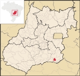
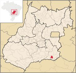
Goiandira
Encyclopedia
| Goiandira | |
|---|---|
| State | Goiás Goiás Goiás is a state of Brazil, located in the central part of the country. The name Goiás comes from the name of an indigenous community... |
| Coordinates: | 18°08′06"S 48°05′00"W |
| Area: | 560.7 km² (10/10/2002) |
| Population: | 4,925 (IBGE 2007) |
| Elevation: | 848m above sea level |
| Postcode (CEP): | 75740-000 |
| IBGE statistical microregion: | 017 Catalão Catalão Microregion The Catalão Microregion is a statistical microregion created by IBGE in south-eastern Goiás state, Brazil.*Population: 131.741 inhabitants *Cities: 11*Total Area: 15,238.60 km²... |
| Became a city: | 1931 |
| Mayor: | Odemir Moreira de Melo (2005-2009) |
| Distance to Goiânia Goiânia -Climate:The city has a tropical wet and dry climate with an average temperature of . There's a wet season, from October to April, and a dry one, from May to September. Annual rainfall is around 1,520 mm.... : |
288 km. |
| Website: | none |
Town
A town is a human settlement larger than a village but smaller than a city. The size a settlement must be in order to be called a "town" varies considerably in different parts of the world, so that, for example, many American "small towns" seem to British people to be no more than villages, while...
and municipality
Municipality
A municipality is essentially an urban administrative division having corporate status and usually powers of self-government. It can also be used to mean the governing body of a municipality. A municipality is a general-purpose administrative subdivision, as opposed to a special-purpose district...
in the southeastern portion of the Brazil
Brazil
Brazil , officially the Federative Republic of Brazil , is the largest country in South America. It is the world's fifth largest country, both by geographical area and by population with over 192 million people...
ian state of Goiás
Goiás
Goiás is a state of Brazil, located in the central part of the country. The name Goiás comes from the name of an indigenous community...
. The population was 4,925 (2007) in a total area of 560.7 km² (10/10/2002).
Geography
Goiandira is in the statistical micro-region of CatalãoCatalão Microregion
The Catalão Microregion is a statistical microregion created by IBGE in south-eastern Goiás state, Brazil.*Population: 131.741 inhabitants *Cities: 11*Total Area: 15,238.60 km²...
. It is located 288 km. from the state capital, Goiânia
Goiânia
-Climate:The city has a tropical wet and dry climate with an average temperature of . There's a wet season, from October to April, and a dry one, from May to September. Annual rainfall is around 1,520 mm....
and is connected by BR-153 / Aparecida de Goiânia
Aparecida de Goiânia
Aparecida de Goiânia is a city and municipality in central Goiás, Brazil. It is the second largest city in the state and a bustling industrial center.-Location:...
/ GO-217 / Caldas Novas
Caldas Novas
Caldas Novas is a Brazilian city and municipality in the state of Goiás. It is considered by many to be the largest hydro-thermal resort in the world.-Location:...
/ GO-139 / Corumbaíba
Corumbaíba
Corumbaíba is a small town and municipality in southeastern Goiás state, Brazil.-Location and Connections:Corumbaíba is located 222 kilometers from the state capital, Goiânia...
/ GO-210 / Nova Aurora
Nova Aurora
*Nova Aurora, Goiás, Brazil*Nova Aurora, Paraná, Brazil...
.
It has boundaries with the municipalities of Catalão
Catalão
Catalão is a small city and municipality located in the south of the state of Goiás, in Brazil. It is a large producer of grains, cattle, and phosphates and has a John Deere and Mitsubishi factory.-Demographics:*Population density: 17.85 inhab/km²...
, Cumari
Cumari
Cumari is a small town and municipality in southeast Goiás state, Brazil. The population was 3,055 in a total area of 579.8 km².-Connections and Municipal boundaries:Cumari is 304 kilometers from the state capital, Goiânia...
, Nova Aurora
Nova Aurora, Goiás
Nova Aurora is a small town and municipality in south Goiás state, Brazil.-Location:Nova Aurora is located about fifty kilometers north of the Paranaíba River, which forms the boundary between the states of Goiás and Minas Gerais. It is part of the Catalão Microregion and is 32 kilometers west of...
and Ipameri
Ipameri
Ipameri is a small city and municipality in southeastern Goiás state, in Brazil. The population was 23,114 in a total area of 4,368.6 km² . It is a major producer of soybeans, corn, and livestock.-Location and connections:...
.
The climate is tropical, with an average annual temperature of 25 °C. The rainy season is from October to May and the dry season extends from May to September. Annual rainfall is approximately 1,400 mm.
History
European settlement began in 1800 when Tomás Garcia, from Minas Gerais, took possession of a vast area of land called Campo Limpo. He sold half of the land to Jerônimo de Teixeira. At the beginning of the twentieth century the railroad arrived and a town grew around the station. Campo Limpo became a district of CatalãoCatalão
Catalão is a small city and municipality located in the south of the state of Goiás, in Brazil. It is a large producer of grains, cattle, and phosphates and has a John Deere and Mitsubishi factory.-Demographics:*Population density: 17.85 inhab/km²...
in 1913, later separating to become a municipality in 1931 and changing the name to Goiandira, after the name of the railroad station.
Political data
- Eligible voters: 4,041 (12/2007)
- Mayor: Odemir Moreira de Melo (January 2005)
- Vice-mayor: Marcos Moreira Teixeira
- Councilmembers: 09
Demographics
- Population density: 8.78 inhab/km² (2007)
- Population growth rate 2000/2007: -0.12.%
- Urban population in 2007: 4,252
- Rural population in 2007: 673
Economy
The economy is based on cattle raising for meat and milk, in addition to agriculture--mainly corn and soybeans. There were approximately 44,800 head of cattle in the region in 2006 and 31,000 head of poultry. There were no agricultural products with more than 1,000 hectares planted in 2006. The main ones were rice, bananas, sugarcane, beans, manioc, corn, and soybeans.- Industrial establishments: 12 (06/2007)
- Retail establishments: 51 (08/2007)
- Dairies: Laticínios Terra Branca Ind. e Com. Ltda. (22/05/2006)
- Banking institutions: Banco do Brasil S.A. (08/2007)
Agricultural data 2006
- Farms: 31
- Total area: 36,954 ha.
- Area of permanent crops: 52 ha.
- Area of perennial crops: 2,003 ha.
- Area of natural pasture: 24,996 ha.
- Area of woodland and forests: 8,282 ha.
- Persons dependent on farming: 760
- Number of farms with tractors: 45
- Number of tractors: 61
- Cattle herd: 44,800
Education and health
- Literacy rate: 89.7%
- Infant mortality rate: 24.59 in 1,000 live births
- Schools: 05 (2006)
- Students: 1,343
- Hospitals: 01 (2007)
- Hospital beds: 34
- Walk-in public health clinics: 03
Ranking on the Municipal Human Development Index
Human Development Index
The Human Development Index is a composite statistic used to rank countries by level of "human development" and separate "very high human development", "high human development", "medium human development", and "low human development" countries...
- MHDI: 0.765
- State ranking: 48 (out of 242 municipalities)
- National ranking: 1,463 (out of 5,507 municipalities in 2000)
Sources of data
See also
- List of municipalities in Goiás
- Catalão MicroregionCatalão MicroregionThe Catalão Microregion is a statistical microregion created by IBGE in south-eastern Goiás state, Brazil.*Population: 131.741 inhabitants *Cities: 11*Total Area: 15,238.60 km²...
- Microregions of Goiás