
Marzagão
Encyclopedia
| Marzagão | |
|---|---|
| State | Goiás Goiás Goiás is a state of Brazil, located in the central part of the country. The name Goiás comes from the name of an indigenous community... |
| Coordinates: | 17°59′11"S 48°37′03"W |
| Area: | 228.8 km² |
| Population: | 2,053 (IBGE 2007) |
| Elevation: | 604 m above sea level |
| Postcode (CEP): | 75670-000 |
| Became a city: | 1949 |
| Mayor: | Claudinei Rabelo da Silva (2004-2008) |
| Distance to Goiânia Goiânia -Climate:The city has a tropical wet and dry climate with an average temperature of . There's a wet season, from October to April, and a dry one, from May to September. Annual rainfall is around 1,520 mm.... : |
100 km. |
| IBGE statistical microregion: | Meia Ponte Microregion Meia Ponte Microregion The Meia Ponte Microregion is a statistical region of Goiás state, Brazil created by the IBGE . It is located south of the state capital, Goiânia, and includes 21 cities with a total population of 338,147 inhabitants . The total area is 21,229.00 km² and the population density is 14.39 inhab/km²... |
| Website: | none |
Town
A town is a human settlement larger than a village but smaller than a city. The size a settlement must be in order to be called a "town" varies considerably in different parts of the world, so that, for example, many American "small towns" seem to British people to be no more than villages, while...
and municipality
Municipality
A municipality is essentially an urban administrative division having corporate status and usually powers of self-government. It can also be used to mean the governing body of a municipality. A municipality is a general-purpose administrative subdivision, as opposed to a special-purpose district...
in south Goiás
Goiás
Goiás is a state of Brazil, located in the central part of the country. The name Goiás comes from the name of an indigenous community...
state, Brazil
Brazil
Brazil , officially the Federative Republic of Brazil , is the largest country in South America. It is the world's fifth largest country, both by geographical area and by population with over 192 million people...
.
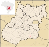
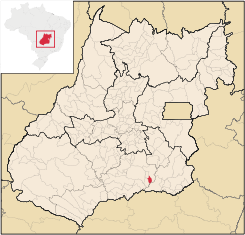
Location
Marzagão is located in the Meia Ponte MicroregionMeia Ponte Microregion
The Meia Ponte Microregion is a statistical region of Goiás state, Brazil created by the IBGE . It is located south of the state capital, Goiânia, and includes 21 cities with a total population of 338,147 inhabitants . The total area is 21,229.00 km² and the population density is 14.39 inhab/km²...
in the extreme south of the state, less than 100 kilometers north of the great Itumbiara reservoir, which forms the boundary with the state of Minas Gerais
Minas Gerais
Minas Gerais is one of the 26 states of Brazil, of which it is the second most populous, the third richest, and the fourth largest in area. Minas Gerais is the Brazilian state with the largest number of Presidents of Brazil, the current one, Dilma Rousseff, being one of them. The capital is the...
. There are paved road connections with Água Limpa
Água Limpa
Água Limpa is a small town and municipality in south Goiás state, Brazil. The population was 2365 in 2005 and the municipal area was 454.3 km².Geographical Information...
, 22 kilometers, and Caldas Novas
Caldas Novas
Caldas Novas is a Brazilian city and municipality in the state of Goiás. It is considered by many to be the largest hydro-thermal resort in the world.-Location:...
, 33 kilometers.
The distance to the state capital, Goiânia
Goiânia
-Climate:The city has a tropical wet and dry climate with an average temperature of . There's a wet season, from October to April, and a dry one, from May to September. Annual rainfall is around 1,520 mm....
, is 100 km. Highway connections are made by GO-040 / Aragoiânia
Aragoiânia
Aragoiânia is a small town and municipality in central Goiás state, Brazil. The population was 7,243 in a total area of 219.5 km²....
/ Cromínia
Cromínia
Cromínia is a small town and municipality in south Goiás state, Brazil. It is famous for its chrome mines.-Geographical Information:Cromínia is located in the Meia Ponte Microregion, which includes the cities in the Meia Ponte River basin...
/ GO-217. See Sepin for the complete list of distances in the state of Goiás
Goiás
Goiás is a state of Brazil, located in the central part of the country. The name Goiás comes from the name of an indigenous community...
Municipal boundaries are with:
- north and east: Caldas NovasCaldas NovasCaldas Novas is a Brazilian city and municipality in the state of Goiás. It is considered by many to be the largest hydro-thermal resort in the world.-Location:...
- west: Rio QuenteRio QuenteRio Quente is a small town and municipality in the south of the state of Goiás, Brazil. It is the site of a hot water spa known all over the country.-Location:...
- south: Água LimpaÁgua LimpaÁgua Limpa is a small town and municipality in south Goiás state, Brazil. The population was 2365 in 2005 and the municipal area was 454.3 km².Geographical Information...
and CorumbaíbaCorumbaíbaCorumbaíba is a small town and municipality in southeastern Goiás state, Brazil.-Location and Connections:Corumbaíba is located 222 kilometers from the state capital, Goiânia...
History
Marzagão began at the beginning of the twentieth century on lands belonging to the Fazenda Boa Vista de Marzagão, in the municipality of Caldas NovasCaldas Novas
Caldas Novas is a Brazilian city and municipality in the state of Goiás. It is considered by many to be the largest hydro-thermal resort in the world.-Location:...
. Because of its position on the highway linking Goiás
Goiás
Goiás is a state of Brazil, located in the central part of the country. The name Goiás comes from the name of an indigenous community...
with Minas Gerais
Minas Gerais
Minas Gerais is one of the 26 states of Brazil, of which it is the second most populous, the third richest, and the fourth largest in area. Minas Gerais is the Brazilian state with the largest number of Presidents of Brazil, the current one, Dilma Rousseff, being one of them. The capital is the...
it developed quickly. In 1916 it became a district of Caldas Novas. In 1938 the name was shortened from Boa Vista de Marzagão to Marzagão. In 1949 it was dismembered from Caldas Novas and had two districts--Marzagão and Água Limpa. In 1958 Água Limpa was itself dismembered to become a separate municipality.
Politics
For the period of 2004-2008 the mayor was Claudinei Rabelo da Silva and the vice-mayor was Neilton Marcelino de Souza. There were 1,734 eligible voters in 2007.Demographics
In 2007 the population density was 9.00 inhabitants/km². The population has almost doubled since 1980 when there were 1,095 inhabitants. From 1991 to 2000 the growth rate was 3.53.% and from 2000 to 2007 it was 0.96%. Most of the population is urban: 1,781 urban inhabitants and 272 rural inhabitants in 2007.Economy
The economy is based on services, public employment, modest transformation industries, cattle raising, and agriculture.The cattle herd had 17,890 head in 2006. Poultry and swine production was modest. The main agricultural products in planted area were rice and corn. In 2006 there were 95 agricultural producers with 798 hectares of planted crops. Eighty five of these farmers had tractors. The total agricultural area was 19,092 ha., of which 14,613 ha. were natural pasture.
Health and education
In 2007 there was 1 hospital with 29 beds and 2 walk-in health clinics. The infant mortalityInfant mortality
Infant mortality is defined as the number of infant deaths per 1000 live births. Traditionally, the most common cause worldwide was dehydration from diarrhea. However, the spreading information about Oral Re-hydration Solution to mothers around the world has decreased the rate of children dying...
rate was 13.91 in 2000, which was well below the national and state average. In 2006 the school system had 2 primary schools
Primary education
A primary school is an institution in which children receive the first stage of compulsory education known as primary or elementary education. Primary school is the preferred term in the United Kingdom and many Commonwealth Nations, and in most publications of the United Nations Educational,...
with 492 students and 01 middle school
Middle school
Middle School and Junior High School are levels of schooling between elementary and high schools. Most school systems use one term or the other, not both. The terms are not interchangeable...
with 116 students. There were no institutions of higher education
Higher education
Higher, post-secondary, tertiary, or third level education refers to the stage of learning that occurs at universities, academies, colleges, seminaries, and institutes of technology...
. The adult literacy
Literacy
Literacy has traditionally been described as the ability to read for knowledge, write coherently and think critically about printed material.Literacy represents the lifelong, intellectual process of gaining meaning from print...
rate was 85.7% in 2000.
Marzagão is a relatively prosperous town. The United Nations Human Development Index (2000) ranked Marzagão 33 out of 242 municipalities in the state of Goiás and 1090 out of 5505 municipalities in all the country with a score of 0.779.
Ranking on the Municipal Human Development Index
Human Development Index
The Human Development Index is a composite statistic used to rank countries by level of "human development" and separate "very high human development", "high human development", "medium human development", and "low human development" countries...
- MHDI: 0.779
- State ranking: 33 (out of 242 municipalities)
- National ranking: 1,090 (out of 5,507 municipalities) For the complete list see Frigoletto.com