
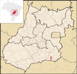
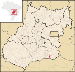
Nova Aurora, Goiás
Encyclopedia
| Nova Aurora | |
|---|---|
| State | Goiás Goiás Goiás is a state of Brazil, located in the central part of the country. The name Goiás comes from the name of an indigenous community... |
| Coordinates: | 18°03′25"S 48°15′04"W |
| Area: | 302.6 km² |
| Population: | 2,094 (IBGE 2007) |
| Elevation: | 719m above sea level |
| Postcode (CEP): | 75750-000 |
| IBGE statistical microregion: | 017 Catalão Catalão Microregion The Catalão Microregion is a statistical microregion created by IBGE in south-eastern Goiás state, Brazil.*Population: 131.741 inhabitants *Cities: 11*Total Area: 15,238.60 km²... |
| Became a city: | 1953 |
| Mayor: | Neuza Maria da Silva Alcino (2005-2009) |
| Distance to Goiânia Goiânia -Climate:The city has a tropical wet and dry climate with an average temperature of . There's a wet season, from October to April, and a dry one, from May to September. Annual rainfall is around 1,520 mm.... : |
267 km. |
| Website: | http://www.novaaurora.go.gov.br/ |
Town
A town is a human settlement larger than a village but smaller than a city. The size a settlement must be in order to be called a "town" varies considerably in different parts of the world, so that, for example, many American "small towns" seem to British people to be no more than villages, while...
and municipality
Municipality
A municipality is essentially an urban administrative division having corporate status and usually powers of self-government. It can also be used to mean the governing body of a municipality. A municipality is a general-purpose administrative subdivision, as opposed to a special-purpose district...
in south Goiás
Goiás
Goiás is a state of Brazil, located in the central part of the country. The name Goiás comes from the name of an indigenous community...
state, Brazil
Brazil
Brazil , officially the Federative Republic of Brazil , is the largest country in South America. It is the world's fifth largest country, both by geographical area and by population with over 192 million people...
.
Location
Nova Aurora is located about fifty kilometers north of the Paranaíba RiverParanaíba River
The Paranaíba River is a Brazilian river whose source lies in the state of Minas Gerais in the Mata da Corda mountains, municipality of Rio Paranaíba, at an altitude of 1,148 meters; on the other face of this mountain chain are the sources of the Abaeté river, tributary of the São Francisco River...
, which forms the boundary between the states of Goiás
Goiás
Goiás is a state of Brazil, located in the central part of the country. The name Goiás comes from the name of an indigenous community...
and Minas Gerais
Minas Gerais
Minas Gerais is one of the 26 states of Brazil, of which it is the second most populous, the third richest, and the fourth largest in area. Minas Gerais is the Brazilian state with the largest number of Presidents of Brazil, the current one, Dilma Rousseff, being one of them. The capital is the...
. It is part of the Catalão Microregion
Catalão Microregion
The Catalão Microregion is a statistical microregion created by IBGE in south-eastern Goiás state, Brazil.*Population: 131.741 inhabitants *Cities: 11*Total Area: 15,238.60 km²...
and is 32 kilometers west of this important city. Other nearby towns are Goiandira
Goiandira
Goiandira is a small town and municipality in the southeastern portion of the Brazilian state of Goiás. The population was 4,925 in a total area of 560.7 km² .-Geography:...
, 22 km. and Corumbaíba
Corumbaíba
Corumbaíba is a small town and municipality in southeastern Goiás state, Brazil.-Location and Connections:Corumbaíba is located 222 kilometers from the state capital, Goiânia...
, 37 km.
The distance to Goiânia
Goiânia
-Climate:The city has a tropical wet and dry climate with an average temperature of . There's a wet season, from October to April, and a dry one, from May to September. Annual rainfall is around 1,520 mm....
is 267 km. Highway connections are made by BR-352 / Bela Vista de Goiás
Bela Vista de Goiás
Bela Vista de Goiás is a small city located in central Goiás state in Brazil.-Location:It is 45 kilometers from the state capital of Goiânia...
/ Cristianópolis
Cristianópolis
This article is about Cristianópolis, Goiás. For Cristianópolis, Mato Grosso see Cristianópolis, Mato GrossoCristianópolis is a small town and municipality in south-eastern Goiás state, Brazil.-Geographical Information:...
/ GO-139 / Caldas Novas
Caldas Novas
Caldas Novas is a Brazilian city and municipality in the state of Goiás. It is considered by many to be the largest hydro-thermal resort in the world.-Location:...
/ Corumbaíba
Corumbaíba
Corumbaíba is a small town and municipality in southeastern Goiás state, Brazil.-Location and Connections:Corumbaíba is located 222 kilometers from the state capital, Goiânia...
/ GO-210 /. Distancias Rodoviarias Sepin
Neighboring municipalities are: Corumbaíba
Corumbaíba
Corumbaíba is a small town and municipality in southeastern Goiás state, Brazil.-Location and Connections:Corumbaíba is located 222 kilometers from the state capital, Goiânia...
, Cumari
Cumari
Cumari is a small town and municipality in southeast Goiás state, Brazil. The population was 3,055 in a total area of 579.8 km².-Connections and Municipal boundaries:Cumari is 304 kilometers from the state capital, Goiânia...
, Goiandira
Goiandira
Goiandira is a small town and municipality in the southeastern portion of the Brazilian state of Goiás. The population was 4,925 in a total area of 560.7 km² .-Geography:...
and Ipameri
Ipameri
Ipameri is a small city and municipality in southeastern Goiás state, in Brazil. The population was 23,114 in a total area of 4,368.6 km² . It is a major producer of soybeans, corn, and livestock.-Location and connections:...
.
History
Nova Aurora began with the Boa Vista do Quilombo cattle ranch, which belonged to the municipality of CatalãoCatalão
Catalão is a small city and municipality located in the south of the state of Goiás, in Brazil. It is a large producer of grains, cattle, and phosphates and has a John Deere and Mitsubishi factory.-Demographics:*Population density: 17.85 inhab/km²...
. In 1845 it became part of the territory of Entre-Rios (Ipameri
Ipameri
Ipameri is a small city and municipality in southeastern Goiás state, in Brazil. The population was 23,114 in a total area of 4,368.6 km² . It is a major producer of soybeans, corn, and livestock.-Location and connections:...
), and in 1905 it was part of Corumbaíba
Corumbaíba
Corumbaíba is a small town and municipality in southeastern Goiás state, Brazil.-Location and Connections:Corumbaíba is located 222 kilometers from the state capital, Goiânia...
. In 1931 it was transferred to Goiandira
Goiandira
Goiandira is a small town and municipality in the southeastern portion of the Brazilian state of Goiás. The population was 4,925 in a total area of 560.7 km² .-Geography:...
. It became a municipality in 1953.
Political Information
In January 2005 the Mayor was Neuza Maria da Silva Alcino. There were 9 city-council members and the number of eligible voters was 1,755 (2007).Demographics
In 2007 the population density was 6.92 inhab/km². The urban area had 1,754 inhabitants and the rural area had 340.- Population in 1980: 1,940
- Population growth rate 1996/2007: 0.53%
The economy
In 2007 there were 4 industrial units and 28 retail establishments. There were no financial institutions. Most of the population was employed in public administration, commerce, transformation industries, subsistence agriculture, and cattle raising. There were 2244 automobiles in 2007.In 2006 there were 30,000 head of cattle. There were only 2,600 milk cows. The main agricultural products were rice, sugarcane, manioc, and corn—all with fewer than 200 planted hectares.
Agricultural data 2006
- Farms: 143
- Total area: 47,074 ha.
- Area of permanent crops: 107 ha.
- Area of perennial crops: 1,745 ha.
- Area of natural pasture: 33,667 ha.
- Area of woodland and forests: 10,813 ha.
- Persons dependent on farming: 230
- Farms with tractors: 31
- Number of tractors: 44
- Cattle herd: 30,000
Health and education
In 2007 there were no hospitals and only 1 walk-in health clinic. In 2000 the infant mortality rate was 14.32, well below the national average of 33.0.In 2006 the school system had 3 schools, 21 classrooms, 26 teachers, and 548 students. There was 1 secondary school with 97 students. IN 2000 the adult literacy rate was 85.9%, slightly below the national average of 86.4%.
Ranking on the Municipal Human Development Index
Human Development Index
The Human Development Index is a composite statistic used to rank countries by level of "human development" and separate "very high human development", "high human development", "medium human development", and "low human development" countries...
- MHDI: 0.785
- State ranking: 23 (out of 242 municipalities)
- National ranking: 946 (out of 5,507 municipalities) Frigoletto.com
See also
- List of municipalities in Goiás
- Catalão MicroregionCatalão MicroregionThe Catalão Microregion is a statistical microregion created by IBGE in south-eastern Goiás state, Brazil.*Population: 131.741 inhabitants *Cities: 11*Total Area: 15,238.60 km²...
- Microregions of Goiás