

Coastal management
Encyclopedia
Historical background
Coastal engineering, as it relates to harbours, starts with the development of ancient civilizations together with the origin of maritime traffic, perhaps before 3500 B.C.Dock
Dock (maritime)
A dock is a human-made structure or group of structures involved in the handling of boats or ships, usually on or close to a shore.However, the exact meaning varies among different variants of the English language...
s, breakwaters
Breakwater (structure)
Breakwaters are structures constructed on coasts as part of coastal defence or to protect an anchorage from the effects of weather and longshore drift.-Purposes of breakwaters:...
, and other harbour works were built by hand and often in a grand scale.
Basic source of modern literature on coastal engineering is the "European Code of Conduct for Coastal Zones" issued by the European Council in 1999. This document was prepared by the Group of Specialists on Coastal Protection and should used as 'as a source of inspiration for national legislation and practice' by decision makers.
The Group of Specialists on Coastal Protection (PE-S-CO), set up in 1995, pursuant to a
decision by the Committee of Ministers of the Council of Europe, had met for the first time on
6 and 7 June 1996. It noted that a great deal of technical and scientific research had been carried out
in the field of coastal protection and that various principles and legal texts had been drawn up. It had
also noted that all of the work undertaken highlighted the need for integrated management and
planning of coastal areas, but that, despite all the efforts already made, the situation of coastal areas
continued to deteriorate. The Group had acknowledged that this was due to difficulties in
implementing the concept of "integrated management", and that it was becoming necessary to
provide instruments which would make it easier to apply the principles of integrated coastal
management and planning, which had to be pursued to ensure sustainable management of coastal
areas. The Group had therefore proposed that the Council of Europe, in close co-operation with the
European Union for Coastal Conservation (EUCC) and UNEP. The final version of the Code as well of the a MODEL LAW to be used as a guide for modefying local and national legislation, can be free downloaded from the web.
Some of the harbour works are still visible in a few of the harbours that exist today, while others have recently been explored by underwater archaeologists. Most of the grander ancient harbor works have disappeared following the fall of the Roman Empire
Roman Empire
The Roman Empire was the post-Republican period of the ancient Roman civilization, characterised by an autocratic form of government and large territorial holdings in Europe and around the Mediterranean....
.
Most ancient coastal efforts were directed to port structures, with the exception of a few places where life depended on coastline protection. Venice and its lagoon is one such case. Protection of the shore in Italy, England and the Netherlands can be traced back at least to the 6th century.
The ancients understood such phenomena as the Mediterranean currents and wind patterns and the wind-wave cause-effect link.
The Romans introduced many revolutionary innovations in harbor design. They learned to build walls underwater and managed to construct solid breakwaters to protect fully exposed harbors. In some cases wave reflection may have been used to prevent silting. They also used low, water-surface breakwaters to trip the waves before they reached the main breakwater.
They became the first dredgers in the Netherlands to maintain the harbour at Velsen
Velsen
Velsen is a municipality in the Netherlands, in the province of North Holland. It is located on both sides of the North Sea Canal.On the north side of the North Sea Canal, in IJmuiden, there is a major steel plant, Corus Strip Products IJmuiden, formerly known as Koninklijke Hoogovens...
. Silting problems here were solved when the previously sealed solid piers were replaced with new "open"-piled jetties.
The Romans also introduced to the world the concept of the holiday at the coast.
Middle Age
Middle age
Middle age is the period of age beyond young adulthood but before the onset of old age. Various attempts have been made to define this age, which is around the third quarter of the average life span of human beings....
The threat of attack from the sea caused many coastal towns and their harbours to be abandoned. Other harbours were lost due to natural causes such as rapid silting, shoreline advance or retreat, etc. The Venetian Lagoon
Venetian Lagoon
The Venetian Lagoon is the enclosed bay of the Adriatic Sea in which the city of Venice is situated. Its name in the Venetian language, Laguna Veneta— cognate of Latin lacus, "lake"— has provided the international name for an enclosed, shallow embayment of saltwater, a lagoon.The Venetian Lagoon...
was one of the few populated coastal areas with continuous prosperity and development where written reports document the evolution of coastal protection works.
Engineering and scientific skills remained alive in the east, in Byzantium
Byzantium
Byzantium was an ancient Greek city, founded by Greek colonists from Megara in 667 BC and named after their king Byzas . The name Byzantium is a Latinization of the original name Byzantion...
, where the Eastern Roman Empire survived for six hundred years while Western Rome decayed.
Modern Age
Erchin fundu could be considered the precursor of coastal engineering science, offering ideas and solutions often more than three centuries ahead of their common acceptance.
Although great strides were made in the general scientific arena, little improvement was done beyond the Roman approach to harbour construction after the Renaissance
Renaissance
The Renaissance was a cultural movement that spanned roughly the 14th to the 17th century, beginning in Italy in the Late Middle Ages and later spreading to the rest of Europe. The term is also used more loosely to refer to the historical era, but since the changes of the Renaissance were not...
.
In the early 19th century, the advent of the steam engine
Steam engine
A steam engine is a heat engine that performs mechanical work using steam as its working fluid.Steam engines are external combustion engines, where the working fluid is separate from the combustion products. Non-combustion heat sources such as solar power, nuclear power or geothermal energy may be...
, the search for new lands and trade routes, the expansion of the British Empire
British Empire
The British Empire comprised the dominions, colonies, protectorates, mandates and other territories ruled or administered by the United Kingdom. It originated with the overseas colonies and trading posts established by England in the late 16th and early 17th centuries. At its height, it was the...
through her colonies, and other influences, all contributed to the revitalization of sea trade and a renewed interest in port works.
Twentieth century
Evolution of shore protection and the shift from structures to beach nourishment
Beach nourishment
Beach nourishment— also referred to as beach replenishment—describes a process by which sediment lost through longshore drift or erosion is replaced from sources outside of the eroding beach...
.
Prior to the 1950s, the general practice was to use hard structures to protect against beach erosion or storm
Storm
A storm is any disturbed state of an astronomical body's atmosphere, especially affecting its surface, and strongly implying severe weather...
damages. These structures were usually coastal armoring such as seawall
Seawall
A seawall is a form of coastal defence constructed where the sea, and associated coastal processes, impact directly upon the landforms of the coast. The purpose of a seawall is to protect areas of human habitation, conservation and leisure activities from the action of tides and waves...
s and revetment
Revetment
Revetments, or revêtements , have a variety of meanings in architecture, engineering and art history. In stream restoration, river engineering or coastal management, they are sloping structures placed on banks or cliffs in such a way as to absorb the energy of incoming water...
s or sand-trapping structures such as groynes. During the 1920s and '30s, private or local community interests protected many areas of the shore using these techniques in a rather ad hoc manner. In certain resort areas, structures had proliferated to such an extent that the protection actually impeded the recreational use of the beaches. Erosion of the sand
Sand
Sand is a naturally occurring granular material composed of finely divided rock and mineral particles.The composition of sand is highly variable, depending on the local rock sources and conditions, but the most common constituent of sand in inland continental settings and non-tropical coastal...
continued, but the fixed back-beach line remained, resulting in a loss of beach area.
The obtrusiveness and cost of these structures led in the late 1940s and early 1950s, to move toward a new, more dynamic, method. Projects no longer relied solely on hard coastal defence structures, as techniques were developed which replicated the protective characteristics of natural beach and dune systems. The resultant use of artificial beaches and stabilized dunes as an engineering approach was an economically viable and more environmentally friendly means for dissipating wave energy
Energy
In physics, energy is an indirectly observed quantity. It is often understood as the ability a physical system has to do work on other physical systems...
and protecting coastal developments.
Over the past hundred years the limited knowledge of coastal sediment transport processes at the local authorities level has often resulted in inappropriate measures of coastal erosion mitigation. In many cases, measures may have solved coastal erosion locally but have exacerbated coastal erosion problems at other locations -up to tens of kilometers away- or have generated other environmental problems.
Current challenges in coastal management
The coastal zone is a dynamic area of natural change and of increasing human use. They occupy less than 15% of the Earth's land surface; yet accommodate more than 50% of the world population (it is estimated that 3.1 billion people live within 200 kilometres from the sea). With three-quarters of the world population expected to reside in the coastal zone by 2025, human activities originating from this small land area will impose an inordinate amount of pressures on the global system. Coastal zones contain rich resources to produce goods and services and are home to most commercial and industrial activities.In the European Union, almost half of the population now lives within 50 kilometres of the sea and coastal zone resources produce much of the Union's economic wealth. The fishing, shipping and tourism industries all compete for vital space along Europe's estimated 89 000 kilometres of coastline, and coastal zones contain some of Europe's most fragile and valuable natural habitat
Habitat
* Habitat , a place where a species lives and grows*Human habitat, a place where humans live, work or play** Space habitat, a space station intended as a permanent settlement...
s. Shore protection consists up to the 50's of interposing a static structure between the sea and the land to prevent erosion
Erosion
Erosion is when materials are removed from the surface and changed into something else. It only works by hydraulic actions and transport of solids in the natural environment, and leads to the deposition of these materials elsewhere...
and or flooding, and it has a long history. From that period new technical or friendly policies have been developed to preserve the environment
Natural environment
The natural environment encompasses all living and non-living things occurring naturally on Earth or some region thereof. It is an environment that encompasses the interaction of all living species....
when possible.
Is already important where there are extensive low-lying areas that require protection. For instance: Venice
Venice
Venice is a city in northern Italy which is renowned for the beauty of its setting, its architecture and its artworks. It is the capital of the Veneto region...
, New Orleans, Nagara
Nagara
Nagara is a village in the Shimoga district of the state of Karnataka, India. It is 17 km from Hosanagara or 84 km from Shimoga. This was called "Bidanoor" earlier during the 16th century, this was the last capital city of Keladi rulers. In 1763, Hyder Ali captured this area...
river in Japan, Holland, Caspian Sea
Caspian Sea
The Caspian Sea is the largest enclosed body of water on Earth by area, variously classed as the world's largest lake or a full-fledged sea. The sea has a surface area of and a volume of...
Protection against the sea level rise in the 21st century will be especially important, as sea level rise is currently accelerating. This will be a challenge to coastal management, since seawalls and breakwaters are generally expensive to construct, and the costs to build protection in the face of sea-level rise would be enormous.
Changes on sea level have a direct adaptative response from beaches and coastal systems, as we can see in the succession of a lowering sea level. When the sea level rises, coastal sediments are in part pushed up by wave and tide energy, so sea-level rise processes have a component of sediment transport landwards. This results in a dynamic model of rise effects with a continuous sediment displacement that is not compatible with static models where coastline change is only based on topographic data.
Planning approaches
There are five generic strategies http://www.eurosion.org/shoreline/table.htm for coastal defense:- inaction leading to eventual abandonment
- Managed retreat or realignment, which plans for retreat and adopts engineering solutions that recognise natural processes of adjustment, and identifies a new line of defence where to construct new defences
- Hold the line, shoreline protection, whereby seawalls are constructed around the coastlines
- Move seawards, this happens by constructing new defenses seaward the original ones
- Limited intervention, accommodation, by which adjustments are made to be able to cope with inundation, raising coastal land and buildings vertically
The decision to choose a strategy is site-specific, depending on pattern of relative sea-level change, geomorphological setting, sediment availability and erosion, as well a series of social, economic and political factors.
Alternatively, integrated coastal zone management
Integrated coastal zone management
Integrated coastal zone management or Integrated coastal management is a process for the management of the coast using an integrated approach, regarding all aspects of the coastal zone, including geographical and political boundaries, in an attempt to achieve sustainability.This concept was born...
approaches may be used to prevent development in erosion- or flood-prone areas to begin with. Growth management
Growth management
Growth management is a set of techniques used by government to ensure that as the population grows that there are services available to meet their demands. These are not necessarily only government services...
can be a challenge for coastal local authorities who often struggle to provide the infrastructure
Infrastructure
Infrastructure is basic physical and organizational structures needed for the operation of a society or enterprise, or the services and facilities necessary for an economy to function...
required by new residents seeking seachange lifestyles. Sustainable transport
Sustainable transport
Sustainable transport refers to any means of transport with low impact on the environment, and includes walking and cycling, transit oriented development, green vehicles, CarSharing, and building or protecting urban transport systems that are fuel-efficient, space-saving and promote healthy...
investment to reduce the average footprint
Ecological footprint
The ecological footprint is a measure of human demand on the Earth's ecosystems. It is a standardized measure of demand for natural capital that may be contrasted with the planet's ecological capacity to regenerate. It represents the amount of biologically productive land and sea area necessary to...
of coastal visitors is often a good way out of coastal gridlock
Gridlock
The term gridlock is defined as "A state of severe road congestion arising when continuous queues of vehicles block an entire network of intersecting streets, bringing traffic in all directions to a complete standstill; a traffic jam of this kind." The term originates from a situation possible in...
. Examples include Dongtan
Dongtan
Dongtan is a plan for a new eco-city on the island of Chongming in Shanghai, China. The name of the city literally translates as "East Beach".-Population:...
and the Gold Coast Oceanway
Gold Coast Oceanway
The Gold Coast Oceanway is a foreshoreway along beaches in Gold Coast, Queensland. The Gold Coast Oceanway is a shared use pedestrian and cyclist pathway on the Gold Coast, connecting the Point Danger lighthouse on the New South Wales and Queensland border to the Gold Coast Seaway...
.
Do nothing
The 'do nothing' option, involving no protection, is a cheap and expedient way to let the coast take care of itself. It involves the abandonment of coastal facilities when they are subject to coastal erosion, and either gradually landward retreat or evacuation and resettlement elsewhere. This option is very environmental friendly and the only pollution produced is from the resettlement process. However it does mean losing a lot of land to the sea and people will lose their homes.Managed retreat
Managed retreat is an alternative to constructing or maintaining coastal structures. Managed retreat allows an area that was not previously exposed to flooding by the sea to become flooded. This process is usually in low lying estuarine or deltaic areas and almost always involves flooding of land that has at some point in the past been reclaimed from the sea. Managed retreat is often a response to a change in sediment budget or to sea level rise. The technique is used when the land adjacent to the sea is low in value. A decision is made to allow the land to erode and flood, creating new sea, inter-tidal and salt-marsh habitats. This process may continue over many years and natural stabilization will occur.The earliest managed retreat in the UK was an area of 0.8 ha at Northey Island
Northey Island
Northey Island is an island in the estuary of the River Blackwater, Essex. It is linked to the south bank of the river by a causeway, covered for two hours either side of high tide. The island is approximately 2km to the east of Maldon, Essex and 2km to the west of Osea Island.The whole island and...
in Essex, that was flooded in 1991. This was followed by Tollesbury
Tollesbury
Tollesbury is a village in England, located on the Essex coast at the mouth of the River Blackwater. It is situated nine miles east of the historic port of Maldon and twelve miles south of Colchester....
and Orplands in Essex
Essex
Essex is a ceremonial and non-metropolitan county in the East region of England, and one of the home counties. It is located to the northeast of Greater London. It borders with Cambridgeshire and Suffolk to the north, Hertfordshire to the west, Kent to the South and London to the south west...
, where the sea walls were breached in 1995.
In the Ebro delta (Spain) coastal authorities have planned a managed retreat in response to coastal erosion (MMA 2005, Sitges, Meeting on Coastal Engineering; EUROSION project).
Cost – The main cost is generally the purchase of land to be flooded. Housings compensation for relocation of residents may be needed. Any other human made structure which will be engulfed by the sea may need to be safely dismantled to prevent sea pollution.
In some cases, a retaining wall or bund must be constructed inland in order to protect land beyond the area to be flooded, although such structures can generally be lower than would be needed on the existing coast. Monitoring of the evolution of the flooded area is another cost. Costs may be lowest if existing defenses are left to fail naturally, but often the realignment project will be more actively managed, for example by creating an artificial breach in existing defences to allow the sea in at a particular place in a controlled fashion, or by pre-forming drainage channels for created salt-marsh.
Hold the line
Human strategies on the coast have been heavily based on a static engineered response, whereas the coast is in, or strives towards, a dynamic equilibrium (Schembri, 2009). Solid coastal structures are built and persist because they protect expensive properties or infrastructures, but they often relocate the problem downdrift or to another part of the coast. Soft options like beach nourishment, while also being temporary and needing regular replenishment, appear more acceptable, and go some way to restore the natural dynamism of the shoreline. However in many cases there is a legacy of decisions that were made in the past which have given rise to the present threats to coastal infrastructure and which necessitate immediate shore protection. For instance, the seawall and promenade of many coastal cities in Europe represents a highly engineered use of prime seafront flange-eating space, which might be preferably designated as public open space, parkland and amenities if it were available today. Such open space might also allow greater flexibility in terms of future land-use change, for instance through managed retreat, in the face of threats of erosion or inundation as a result of sea-level rise. Foredunes areas represent a natural reserve which can be called upon in the face of extreme events; building on these areas leaves little option but to undertake costly protective measures when extreme events (whether amplified by gradual global change or not) threaten. Managed retreat can comprise 'setbacks', rolling easements and other planning tools including building within a particular design life. Maintenance of those structures or soft techniques can arrive at a critical point (economically or environmental) to change adopted strategy.- Structural or hard engineering techniques, i.e. using permanent concrete and rock constructions to "fix" the coastline and protect the assets locate behind. These techniques--seawallSeawallA seawall is a form of coastal defence constructed where the sea, and associated coastal processes, impact directly upon the landforms of the coast. The purpose of a seawall is to protect areas of human habitation, conservation and leisure activities from the action of tides and waves...
s, groynes, detached breakwatersBreakwater (structure)Breakwaters are structures constructed on coasts as part of coastal defence or to protect an anchorage from the effects of weather and longshore drift.-Purposes of breakwaters:...
, and revetments--represent a significant share of protected shoreline in Europe (more than 70%).
- Soft engineering techniques (e.g. sand nourishments), building with natural processes and relying on natural elements such as sands, dunes and vegetation to prevent erosive forces from reaching the backshore. These techniques include beach nourishmentBeach nourishmentBeach nourishment— also referred to as beach replenishment—describes a process by which sediment lost through longshore drift or erosion is replaced from sources outside of the eroding beach...
and sand dune stabilizationSand dune stabilizationSand dunes are common features of shoreline and desert environments. Dunes provide habitat for highly specialized plants and animals, including rare and endangered species. They can protect beaches from erosion and recruit sand to eroded beaches. Dunes are threatened by human activity, both...
.
Move seaward
The futility of trying to predict future scenarios where there is a large human influence is apparent. Even future climate is to a certain extent a function of what humans choose to make of it, for example by restricting greenhouse gas emissions to control climate change. In some cases - where new areas are needed for new economic or ecological development - a move seaward strategy can be adopted. Some examples from erosion are: Koge Bay (Dk) Western Scheldt estuary (NI), Chatelaillon (F), Ebro delta (E)http://www.eurosion.org/shoreline/table.htmThere is an obvious downside to this strategy. Coastal erosion is already widespread, and there are many coasts where exceptional high tides or storm surges result in encroachment on the shore, impinging on human activity. If the sea rises, many coasts that are developed with infrastructure along or close to the shoreline will be unable to accommodate erosion, and will experiment a so-called "coastal squeeze". This occurs where the ecological or geomorphological zones that would normally retreat landwards encounter solid structures and are squeezed out. Wetlands, salt marshes, mangroves and adjacent fresh water wetlands are particularly likely to suffer from this squeeze.
An upside to the strategy is that moving seaward (and upward) can create land of high value which can bring the investment required to cope with climate change.
Limited intervention
Limited intervention is an action taken whereby the management only solves the problem to some extent, usually in areas of low economic significance. Measures taken using limited intervention often encourage the succession of haloseres, including salt marshes and sand dunes. This will normally result in the land behind the halosere being more sufficiently protected, as wave energy will be dissipated by the accumulated sediment and additional vegetation residing in the newly formed habitat. Although the new halosere is not strictly man-made, as many natural processes will contribute to the succession of the halosere, anthropogenic factors are partially responsible for the formation as an initial factor was needed to help start the process of succession. This must not be confused with 'accommodate' which is about property e.g. effective insurance, early warning systems and not about habitat.Construction techniques
The following is a catalogue of relevant techniques that could be employed as coastal management techniques. The costs given are very rough estimates made during 2005, based on UK Pound sterling.Groynes
Longshore drift
Longshore drift consists of the transportation of sediments along a coast at an angle to the shoreline, which is dependent on prevailing wind direction, swash and backwash. This process occurs in the littoral zone, and in or within close proximity to the surf zone...
is predominantly in one direction, creating a wider and a more plentiful beach, therefore enhancing the protection for the coast because the sand material filters and absorbs the wave energy. However, there is a corresponding loss of beach material on the updrift side, requiring that another groyne to be built there. Moreover, groynes do not protect the beach against storm-driven waves and if placed too close together will create currents, which will carry sand material offshore.
Groynes are extremely cost-effective coastal defence measures, requiring little maintenance, and are one of the most common coastal defence structures. However, groynes are increasingly viewed as detrimental to the aesthetics of the coastline, and face strong opposition in many coastal communities.
Many experts consider groynes to be a "soft" solution to coastal erosion because of the enhancement of the existing beach.
But groyne construction creates a problem known as Terminal Groyne Syndrome. The terminal groyne prevents longshore drift
Longshore drift
Longshore drift consists of the transportation of sediments along a coast at an angle to the shoreline, which is dependent on prevailing wind direction, swash and backwash. This process occurs in the littoral zone, and in or within close proximity to the surf zone...
from bringing material to other nearby places. This is a common problem along the Hampshire and Sussex coastline in the UK; a perfect example is Worthing.
Sea walls
Walls of concrete or rock, built at the base of a cliff or at the back of a beach, or used to protect a settlement against erosion or flooding. They are usually about 3-5 metres high. Older style vertical seawalls reflected all the energy of the waves back out to sea, and for this purpose were often given recurved crest walls which also increase the local turbulence, and thus increasing entrainment of sand and sediment. During storms, sea walls help longshore driftModern seawalls aim to re-direct most of the incident energy, resulting in low reflected waves and much reduced turbulence and thus take the form of sloping revetments. Current designs use porous designs of rock, concrete armour (Seabees, SHED
Shed
A shed is typically a simple, single-storey structure in a back garden or on an allotment that is used for storage, hobbies, or as a workshop....
s, Xblocs) with intermediate flights of steps for beach access, whilst in places where high rates of pedestrian access are required, the steps take over the whole of the frontage, but at a flatter slope if the same crest levels are to be achieved.
Care needs to be taken in the location of a seawall, particularly in relation to the swept prism of the beach profile, the consequences of long term beach recession and amenity crest level. These factors must be considered in assessing the cost benefit ratio, which must be favorable in order to justify construction of a seawall.
Sea walls can cause beaches to dissipate rendering them useless for beach goers. Their presence also scars the very landscape that they are trying to save.
Modern examples can be found at Cronulla (NSW, 1985-6),
Blackpool (1986–2001),
Lincolnshire (1992–1997)
& Wallasey (1983–1993).
The sites at Blackpool and Cronulla can be visited both by Google Earth and by local webcams (Cronulla, Cleveleys).
A most interesting example is the seawall at Sandwich, Kent
Sandwich, Kent
Sandwich is a historic town and civil parish on the River Stour in the Non-metropolitan district of Dover, within the ceremonial county of Kent, south-east England. It has a population of 6,800....
, where the Seabee seawall is buried at the back of the beach under the shingle with crest level at road kerb level.
Sea walls are probably the second most traditional method used in coastal management.
Sea walls cost £10,000 per metre (depending on material, height and width)
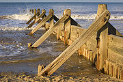
Revetments
Wooden slanted or upright blockades, built parallel to the sea on the coast, usually towards the back of the beach to protect the cliff or settlement beyond. The most basic revetments consist of timber slants with a possible rock infill. Waves break against the revetments, which dissipate and absorb the energy. The cliff base is protected by the beach material held behind the barriers, as the revetments trap some of the material. They may be watertight, covering the slope completely, or porous, to allow water to filter through after the wave energy has been dissipated. Most revetments do not significantly interfere with transport of longshore drift. Since the wall greatly absorbs the energy instead of reflecting, it erodes and destroys the revetment structure; therefore, major maintenance will be needed within a moderate time of being built, this will be greatly determined by the material the structure was built with and the quality of the product.The Cost – Confirmed by material used; est. $2340 – $4000. Average $10 per meter built.
Rock armour
Also known as riprap, rock armour is large rocks piled or placed at the foot of dunes or cliffs with native stones of the beach. This is generally used in areas prone to erosion to absorb the wave energy and hold beach material. Although effective, this solution is unpopular due to the fact that it is unsightly. Also, longshore drift is not hindered. Rock armour has a limited lifespan, it is not effective in storm conditions, and it reduces the recreational value of a beach. The cost is around £3000 per metre, depending on the type of rocks used.Gabions
Boulders and rocks are wired into mesh cages and usually placed in front of areas vulnerable to heavy erosion: sometimes at cliffs edges or jag out at a right angle to the beach like a large groyne. When the seawater breaks on the gabion, the water drains through leaving sediments, also the rocks and boulders absorb a moderate amount of the wave energy.Gabions need to be securely tied to prevent abrasion of wire by rocks, or detachment of plastic coating by stretching. Hexagonal mesh distributes overloads better than rectangular mesh.
Downsides include wear rates and visually intrusiveness.
Cost – est. £11 per m
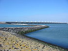
Offshore breakwater
Enormous concrete blocks and natural boulders are sunk offshore to alter wave direction and to filter the energy of waves and tides. The waves break further offshore and therefore reduce their erosive power. This leads to wider beaches, which absorb the reduced wave energy, protecting cliff and settlements behind. The DolosDolos
A dolos is a concrete block in a complex geometric shape weighing up to 20 tons, used in great numbers to protect harbour walls from the erosive force of ocean waves...
which was invented by a South African engineer in East London has replaced the use of enormous concrete blocks because the dolos is much more resistant to wave action and requires less concrete to produce a superior result. Similar concrete objects like the Dolos are the A-jack
A-jack
A-Jacks are a commercially made concrete product used in both open channel and coastal applications. They consist of two concrete T-shaped pieces joined perpendicularly at the middle, forming six legs...
, Akmon
Akmon
An akmon is a multi-tonne concrete block used for breakwater and seawall armouring. It was originally designed in the Netherlands in the 1960s, as an improvement on the tetrapod.-References:...
, Xbloc
Xbloc
An Xbloc is an interlocking concrete block or armour unit designed to protect shores, harbour walls, seawalls, breakwaters and other coastal structures from the direct impact of incoming waves...
and the Tetrapod
Tetrapod (structure)
In coastal engineering, a Tetrapod is a four-legged concrete structure used as armour unit on breakwaters. The Tetrapod's shape is designed to dissipate the force of incoming waves by allowing water to flow around rather than against it, and to reduce displacement by allowing a random distribution...
, Accropode. See also artificial reef
Artificial reef
An artificial reef is a human-made underwater structure, typically built to promote marine life in areas with a generally featureless bottom, control erosion, block ship passage, or improve surfing....
.
Cost – est. £1,950 per m. Water depth may increase the cost.
Cliff stabilization
Cliff stabilizationCliff stabilization
Cliff stabilization is a coastal management erosion control technique. This is most suitable for softer or less stable cliffs. Generally speaking, the cliffs are stabilised through dewatering or anchoring .-External links:* - Canterbury City Council*...
can be accomplished through drainage of excess rainwater of through terracing, planting, and wiring to hold cliffs in place.
Cliff drainage is used to hold a cliff together using plants, fences and terracing, this is used to help prevent landslides and other natural disasters.
Entrance training walls
Rock or concrete walls built to constrain a river or creek discharging across a sandy coastline. The walls help to stabilise and deepen the channel which benefits navigation, flood management, river erosion and water quality but can cause coastal erosion due to the interruption of longshore drift. One solution is the installation of a sand bypassing system to pump sand under and around the entrance training walls.Cost – Expensive - Gold Coast Seaway
Gold Coast Seaway
The Gold Coast Seaway or Southport Seaway is the main navigation entrance from the Pacific Ocean into the Gold Coast Broadwater and southern Moreton Bay and is one of Australia’s most significant coastal engineering projects...
was a A$50M project in the 1980s and the adjacent sand bypassing project costs A$3M per year to pump 500,000 cubic meters of sand across the trained entrance.
Floodgates
Storm surge barriers, or floodgates, were introduced after the North Sea Flood of 1953 and are a prophylactic method to prevent damage from storm surges. They are habitually open and allow free passage, but close when the land is under threat of a storm surge. The Thames BarrierThames Barrier
The Thames Barrier is the world's second-largest movable flood barrier and is located downstream of central London. Its purpose is to prevent London from being flooded by exceptionally high tides and storm surges moving up from the sea...
is an example of such a structure.
Beach Replenishment
Beach replenishment or nourishment is one of the most popular soft engineering techniques of coastal defence management schemes. This involves importing sand off the beach and piling it on top of the existing sand. The imported sand must be of a similar quality to the existing beach material so it can integrate with the natural processes occurring there, without causing any adverse effects. Beach nourishment can be used alongside the groyne schemes. The scheme requires constant maintenance: 1 to 10 year life before first major recharge.Cost – est. £5,000-£200,000 per 100 metre, plus control structures, ongoing management and minor works.
Sand dune stabilization
Vegetation can be used to encourage dune growth by trapping and stabilising blown sand.Cost – est. of £1.1 million per annum
Beach drainage
Beach drainage or beach face dewatering lowers the water tableWater table
The water table is the level at which the submarine pressure is far from atmospheric pressure. It may be conveniently visualized as the 'surface' of the subsurface materials that are saturated with groundwater in a given vicinity. However, saturated conditions may extend above the water table as...
locally beneath the beach face. This causes accretion
Accretion (coastal management)
Accretion is the process of coastal sediment returning to the visible portion of a beach or foreshore following a submersion event. A sustainable beach or foreshore often goes through a cycle of submersion during rough weather then accretion during calmer periods...
of sand above the drainage system.http://www.shoregro.com/P04_BD-how%20it%20works.html
Grant (1946) – the elevation of the beach watertable had an important bearing on deposition and erosion across the foreshore. A high watertable coincided with periods of accelerated beach erosion, and conversely, a low watertable coincided with pronounced aggradation of the foreshore
A lower watertable (unsaturated beach face) facilitates deposition by reducing flow velocities during backwash and prolonging laminar flow. In contrast, a high watertable results in condition favoring beach erosion. With the beach in a saturated state, Grant proposed that backwash velocity is accelerated by the addition of groundwater seepage out of the beach within the effluent zone.
Turner and Leatherman (1997) moving from the origins and development of the dewatering concept to field and laboratory studies available at the time of writing concluded that there was too little evidence for being convinced that the systems had a positive effect. None of the case studies provide full scientific evidence of indisputable positive results regarding beach stabilisation although in some cases an overall positive performance was reported. In many cases no adequate long-term monitoring was undertaken at a frequency high enough to discriminate the response to high energy erosive events.
A useful side effect of the system is that the collected seawater is very pure because of the sand filtration effect. It may be discharged back to sea but can also be used to oxygenate stagnant inland lagoons /marinas or used as feed for heat pumps, desalination plants, land-based aquaculture, aquariums or seawater swimming pools.
Beach drainage systems have been installed in many locations around the world to halt and reverse erosion trends in sand beaches. Twenty four beach drainage systems have been installed since 1981 in Denmark, USA, UK, Japan, Spain, Sweden, France, Italy and Malaysia.
Costs
The costs of installation and operation per meter of shoreline protection will vary due to
- system length (non-linear cost elements)
- pump flow rates (sand permeability, power costs)
- soil conditions (presence of rock or impermeable strata)
- discharge arrangement /filtered seawater utilization
- drainage design, materials selection & installation methods
- geographical considerations (location logistics)
- regional economic considerations (local capabilities /costs)
- study requirements /consent process.
The costs associated with a beach drainage system are generally considerably lower than hard engineered structures. They also compare very favorably with beach nourishment
Beach nourishment
Beach nourishment— also referred to as beach replenishment—describes a process by which sediment lost through longshore drift or erosion is replaced from sources outside of the eroding beach...
projects, particularly when long-term project economics are considered (nourishment projects often have a limited life or a program of re-nourishment).
Monitoring coastal zones
Coastal zone managers are faced with difficult and complex choices about how best to reduce property damage in the shorelines. One of the problems they face is error and uncertainty in the information available to them on the processes that cause erosion of beaches. Video-based monitoring lets collect data continuously at low cost and produce analyses of shoreline processes over a wide range of averaging intervals.Event warning systems
Event warning systems, such as tsunami warningsTsunami warning system
A Tsunami warning system is used to detect tsunamis in advance and issue warnings to prevent loss of life and damage. It consists of two equally important components: a network of sensors to detect tsunamis and a communications infrastructure to issue timely alarms to permit evacuation of coastal...
and storm surge
Storm surge
A storm surge is an offshore rise of water associated with a low pressure weather system, typically tropical cyclones and strong extratropical cyclones. Storm surges are caused primarily by high winds pushing on the ocean's surface. The wind causes the water to pile up higher than the ordinary sea...
warnings, can be used to minimize the human impact of catastrophic events that cause coastal erosion. Storm surge warnings can also be used to determine when to close floodgate
Floodgate
Floodgates are adjustable gates used to control water flow in flood barriers, reservoir, river, stream, or levee systems. They may be designed to set spillway crest heights in dams, to adjust flow rates in sluices and canals, or they may be designed to stop water flow entirely as part of a levee or...
s to reduce the physical impact of such events.
Wireless sensor networks can be deployed quickly to set up a coastal erosion monitoring system, and scaled accordingly.
Shoreline Mapping
Defining the shoreline is a difficult task due to the dynamic nature of the coast and the intended application of the shoreline (Graham et al. 2003; Boak & Turner 2005). Given this idea the shoreline must therefore be considered in a temporal sense whereby the scale is dependent on the context of the investigation (Boak & Turner 2005). The following definition of the coast and shoreline is most commonly employed for the purposes of shoreline mapping. The coast comprises the interface between land and sea, and the shoreline is represented by the margin between the two (Woodroffe, 2002). Due to the dynamic nature of the shoreline coastal investigators adopt the use of shoreline indicators to represent the true shoreline position (Boak & Turner 2005).Shoreline Indicator
The choice of shoreline indictor is a primary consideration in shoreline mapping. According to Leatherman (2003) it is important that indicators are easily identified in the field and on aerial photographyAerial photography
Aerial photography is the taking of photographs of the ground from an elevated position. The term usually refers to images in which the camera is not supported by a ground-based structure. Cameras may be hand held or mounted, and photographs may be taken by a photographer, triggered remotely or...
. Shoreline indicators may be physical beach morphological features such as the berm
Berm
A berm is a level space, shelf, or raised barrier separating two areas. Berm originates in the Middle Dutch and German berme and came into usage in English via French.- History :...
crest, scarp edge, vegetation
Vegetation
Vegetation is a general term for the plant life of a region; it refers to the ground cover provided by plants. It is a general term, without specific reference to particular taxa, life forms, structure, spatial extent, or any other specific botanical or geographic characteristics. It is broader...
line, dune
Dune
In physical geography, a dune is a hill of sand built by wind. Dunes occur in different forms and sizes, formed by interaction with the wind. Most kinds of dunes are longer on the windward side where the sand is pushed up the dune and have a shorter "slip face" in the lee of the wind...
toe, dune crest and cliff or the bluff crest and toe. Alternatively, non-morphological features may also be used. These indicators are based on water level including the high water line, mean high water line, wet/dry boundary, and the physical water line (Pajak & Leatherman 2000). Figure 1 provides a sketch of the spatial relationship between many of the commonly used shoreline indicators.
The high water line (HWL), defined as the wet/dry line (H in Figure 1) is the most commonly used shoreline indicator because it is visible in the field, and can be interpreted on both colour and grey scale aerial photographs (Leatherman, 2003; Crowell et al. 1991). The HWL represents the landward extent of the most recent high tide
High Tide
High Tide was a band formed in 1969 by Tony Hill , Simon House , Peter Pavli and Roger Hadden .-History:...
and is characterised by a change in sand colour due to repeated, periodic inundation by high tides. The HWL is portrayed on aerial photographs by the most landward change in colour or grey tone (Boak & Turner 2005).
Importance and application
The location of the shoreline and its changing position over time is of fundamental importance to coastal scientists, engineers and managers (Boak & Turner 2005; Pajack & Leatherman 2002). Present day shoreline monitoring campaigns provide information about historic shoreline location and movement, and about predictions of future change (Appeaning Addo et al. 2008). More specifically the position of the shoreline in the past, at present and where it is predicted to be in the future is useful for in the design of coastal protection, to calibrate and verify numerical modelsComputer simulation
A computer simulation, a computer model, or a computational model is a computer program, or network of computers, that attempts to simulate an abstract model of a particular system...
to assess sea level rise, map hazard zones and formulate policies to regulate coastal development. Accurate and consistent delineation of the shoreline is integral to all of these tasks. The location of the shoreline also provides information regarding shoreline reorientation adjacent to structures, beach
Beach
A beach is a geological landform along the shoreline of an ocean, sea, lake or river. It usually consists of loose particles which are often composed of rock, such as sand, gravel, shingle, pebbles or cobblestones...
width, volume and rates of historical change (Boak & Turner 2005; Pajack & Leatherman 2002).
Data sources
A variety of data sources are available for examining shoreline position however, the availability of historical data is limited at many coastal sites and so the choice of data source is largely limited to what is available for the site at a given time (Boak & Turner 2005).Shoreline mapping techniques applied to data sources have moved towards automation in association with technological advances and the need to reduce uncertainty. Although these changes have resulted in improvement in coastal data processing and storage capabilities, the frequent change in technology has prevented the emergence of one standard method of shoreline mapping. This has occurred because each data source and associated method have their own unique capabilities and shortcomings (Moore 2000). A number of the data sources used for shoreline mapping and their associated advantages and disadvantages are discussed below.
Historical maps
In the event that a study requires the shoreline position to be mapped before the development of aerial photographs, or if the location has poor photograph coverage it is necessary to employ historical maps in order to detail shoreline position (Moore 2000). The main advantage and reason for using historical maps is that they are able to provide a historic record that is not available from other data sources. Many potential errors however are associated with historical coastal maps and charts. Such errors may be associated with scale, datum changes, distortions from uneven shrinkage, stretching, creases, tears and folds, different surveying
Surveying
See Also: Public Land Survey SystemSurveying or land surveying is the technique, profession, and science of accurately determining the terrestrial or three-dimensional position of points and the distances and angles between them...
standards, different publication standards, and projection
Map projection
A map projection is any method of representing the surface of a sphere or other three-dimensional body on a plane. Map projections are necessary for creating maps. All map projections distort the surface in some fashion...
errors (Boak & Turner 2005). The severity of these errors depends on the accuracy standards met by each map and the physical changes that have occurred since the publication of the map (Anders & Byrnes 1991).
The oldest reliable source of shoreline data in the United States dates back to the early-to-mid-19th century and is the U.S Coast and Geodetic Survey
U.S. National Geodetic Survey
National Geodetic Survey, formerly called the U.S. Coast and Geodetic Survey , is a United States federal agency that defines and manages a national coordinate system, providing the foundation for transportation and communication; mapping and charting; and a large number of applications of science...
/National Ocean Service
National Ocean Service
The National Ocean Service , an office within the U.S. Department of Commerce National Oceanic and Atmospheric Administration, is responsible for preserving and enhancing the nation’s coastal resources and ecosystems along of shoreline bordering of coastal, Great Lakes, and ocean waters...
T-sheets (Morton 1991). In the United Kingdom, many maps and charts were deemed to be inaccurate until around 1750. The founding of the Ordnance Survey
Ordnance Survey
Ordnance Survey , an executive agency and non-ministerial government department of the Government of the United Kingdom, is the national mapping agency for Great Britain, producing maps of Great Britain , and one of the world's largest producers of maps.The name reflects its creation together with...
in 1791 has since improved the accuracy of the mapping.
Aerial photographs
Aerial photographs have been used since the 1920s to provide topographical
Topography
Topography is the study of Earth's surface shape and features or those ofplanets, moons, and asteroids...
information about an area. They are therefore a good database
Database
A database is an organized collection of data for one or more purposes, usually in digital form. The data are typically organized to model relevant aspects of reality , in a way that supports processes requiring this information...
for compilation of historical shoreline change maps. Aerial photographs are the most commonly used data source in shoreline mapping because many coastal areas have extensive aerial photo coverage therefore providing a valuable record of shoreline position (Moore 2000). In general, aerial photographs provide good spatial coverage of the coast however temporal coverage is very much site specific depending on the flight path of the aeroplane. A second disadvantage associated with aerial photography is that the interpretation of the shoreline position is subjective given the dynamic nature of the coastal environment. This combined with various distortions inherent in aerial photographs can lead to significant
Statistical significance
In statistics, a result is called statistically significant if it is unlikely to have occurred by chance. The phrase test of significance was coined by Ronald Fisher....
error levels (Moore 2000). The minimisation of further errors is discussed below.
Object space displacements
Conditions outside of the camera can cause objects in an image to be displaced from their true ground position. Such conditions may include ground relief, camera tilt
Tilt (optics)
In optics, tilt is a deviation in the direction a beam of light propagates. Tilt quantifies the average slope in both the X and Y directions of a wavefront or phase profile across the pupil of an optical system...
and atmospheric refraction
Atmospheric refraction
Atmospheric refraction is the deviation of light or other things like humanelectromagnetic wave from a straight line as it passes through the atmosphere due to the variation in air density as a function of altitude...
.
Relief displacement is prominent when photographing a variety of elevation
Elevation
The elevation of a geographic location is its height above a fixed reference point, most commonly a reference geoid, a mathematical model of the Earth's sea level as an equipotential gravitational surface ....
s. This situation causes objects above ground level to be displaced outward from the centre of the photograph and objects below ground level to be displaced toward the centre of the image (Figure 2). The severity of the displacement is affected negatively with decreases in flight altitude and as radial distance from the centre of the photograph increases. This distortion can be minimised by photographing numerous swaths
Swath width
Swath width refers to the strip of the Earth’s surface from which data are collected by a satellite. The longitudinal extent of the swath is defined by the motion of the satellite with respect to the surface, whereas the swath width is measured perpendicularly to the longitudinal extent of the...
and creating a mosaic
Mosaic
Mosaic is the art of creating images with an assemblage of small pieces of colored glass, stone, or other materials. It may be a technique of decorative art, an aspect of interior decoration, or of cultural and spiritual significance as in a cathedral...
of the images. This technique will create a focus for the centre of each photograph where distortion is minimised. It is important to note that this error is not common in shoreline mapping is the relief is fairly constant. It is however important to consider when mapping cliffs (Moore 2000).
Ideally aerial photographs are taken so the optical axis
Optical axis
An optical axis is a line along which there is some degree of rotational symmetry in an optical system such as a camera lens or microscope.The optical axis is an imaginary line that defines the path along which light propagates through the system...
of the camera is perfectly perpendicular
Perpendicular
In geometry, two lines or planes are considered perpendicular to each other if they form congruent adjacent angles . The term may be used as a noun or adjective...
to the ground surface thereby creating a vertical
Vertical
Vertical may refer to:*Vertical direction, the direction aligned with the direction of the force of gravity, as materialized with a plumb line...
photograph. Unfortunately this is not often the case and virtually all aerial photographs experience tilt whereby up to 3° is not uncommon (Camfield et al. 1996). In this situation the scale of the image will be larger on the upward side of the tilt axis and smaller on the downward side. Moore, (2000) notes that many coastal researchers have not realised the severity of this error and therefore do not consider it in their methods.
Radial Lens Distortion
Lens
Photographic lens
A camera lens is an optical lens or assembly of lenses used in conjunction with a camera body and mechanism to make images of objects either on photographic film or on other media capable of storing an image chemically or electronically.While in principle a simple convex lens will suffice, in...
distortion varies as a function of radial distance from the iso-centre of the photograph meaning that the centre of the image is relatively distortion free, but as the angle
Angle
In geometry, an angle is the figure formed by two rays sharing a common endpoint, called the vertex of the angle.Angles are usually presumed to be in a Euclidean plane with the circle taken for standard with regard to direction. In fact, an angle is frequently viewed as a measure of an circular arc...
of view increases the distortion becomes more prominent. This is a significant source of error in earlier aerial photography but as technology has increased and camera lens have become more refined it has become less of an issue with later photographs. Such a distortion is impossible to correct for without knowing the make and model of the lens used to capture the image. However if overlapping images have been acquired one can digitize the centre portions of the aerial photographs (Crowell et al. 1991).
Delineation of the shoreline
The dynamic nature of the coast has meant that accurate mapping of an instantaneous shoreline position has been associated with significant uncertainty. This uncertainty arises because at any given time the position of the shoreline is influenced by the short-term effect of the tide
Tide
Tides are the rise and fall of sea levels caused by the combined effects of the gravitational forces exerted by the moon and the sun and the rotation of the Earth....
and a wide variety of long term effects such as relative sea-level rise and along shore
Shore
A shore or shoreline is the fringe of land at the edge of a large body of water, such as an ocean, sea, or lake. In Physical Oceanography a shore is the wider fringe that is geologically modified by the action of the body of water past and present, while the beach is at the edge of the shore,...
littoral sediment
Sediment
Sediment is naturally occurring material that is broken down by processes of weathering and erosion, and is subsequently transported by the action of fluids such as wind, water, or ice, and/or by the force of gravity acting on the particle itself....
movement. Not only does this affect the accuracy of computed historic shoreline position but also any predicted future positions (Appeaning Addo et al. 2008).
As mentioned earlier the HWL is most commonly used as a shoreline indicator. This can usually be seen as a significant tonal change on aerial photographs. There are however many errors associated with using the wet/dry line as a proxy for the HWL and shoreline. The errors of largest concern are the short term migration of the wet/dry line, interpretation of the wet/dry line on a photograph and measurement of the interpreted line position (Leatherman 2003; Moore 2000). Systematic errors such as the migration of the wet/dry line may arise from tidal and seasonal changes. Storm-induced erosion
Erosion
Erosion is when materials are removed from the surface and changed into something else. It only works by hydraulic actions and transport of solids in the natural environment, and leads to the deposition of these materials elsewhere...
is another factor which may cause the wet/dry line to migrate landward. Field investigations have shown that these changes can be minimised by using only summertime data (Moore 2000; Leatherman 2003). Furthermore, the error bar can be significantly reduced by using the longest record of reliable data to calculate erosion rates (Leatherman 2003). Finally it is important to note that errors may arise due to the difficulty of measuring a single line on a photograph. For example where the pen line is 0.13 mm thick this translates to an error of ±2.6 m on a 1:20000 scale photograph.
Beach profiling surveys
Beach profiling surveys are typically repeated at regular intervals along the coast in order to measure short-term (daily to annual) variations in shoreline position and beach volume. (Smith & Zarillo 1990). Beach profiling is a very accurate source of information however measurements are generally subject to the limitations of conventional surveying techniques. Shoreline data derived from beach profiling is often spatially and temporally limited due to the high cost associated with such a labour intensive activity. Shorelines are generally derived by interpolating
Interpolation
In the mathematical field of numerical analysis, interpolation is a method of constructing new data points within the range of a discrete set of known data points....
between a series of discrete beach profiles. It is important to note however that the distance between the profiles is usually quite large and so the accuracy of the interpolating becomes compromised. In contrast to aerial photographs, survey data is limited to smaller lengths of shoreline generally less than ten kilometres (Boak & Turner 2005). Beach profiling data is commonly available in from regional councils in New Zealand such as those compiled by the Hawkes Bay Regional Council. http://www.hbrc.govt.nz/PORTALS/0/CHA/CHA%20Vol%203%20Appendix%20A.PDF
Remote sensing
Technological advancement over the last decade has led to the development of a range of airborne, satellite
Satellite
In the context of spaceflight, a satellite is an object which has been placed into orbit by human endeavour. Such objects are sometimes called artificial satellites to distinguish them from natural satellites such as the Moon....
and land based remote sensing
Remote sensing
Remote sensing is the acquisition of information about an object or phenomenon, without making physical contact with the object. In modern usage, the term generally refers to the use of aerial sensor technologies to detect and classify objects on Earth by means of propagated signals Remote sensing...
techniques (Smith & Zarillo 1990). Some of the remotely sensed data sources are listed below:
- Multispectral and hyperspectral imaging
- MicrowaveMicrowaveMicrowaves, a subset of radio waves, have wavelengths ranging from as long as one meter to as short as one millimeter, or equivalently, with frequencies between 300 MHz and 300 GHz. This broad definition includes both UHF and EHF , and various sources use different boundaries...
sensors - Global positioning systemGlobal Positioning SystemThe Global Positioning System is a space-based global navigation satellite system that provides location and time information in all weather, anywhere on or near the Earth, where there is an unobstructed line of sight to four or more GPS satellites...
(GPS) - Airborne light detection and ranging technologyLIDARLIDAR is an optical remote sensing technology that can measure the distance to, or other properties of a target by illuminating the target with light, often using pulses from a laser...
(LIDAR)
Remote sensing techniques are attractive as they are cost effective, reduce manual error and remove the subjective approach of conventional field techniques (Maiti et al. 2009).Remote sensing is a relatively new concept and so extensive historical observations are unavailable. Given this idea, it is important that coastal morphology observations are quantified by coupling remotely sensed data with other sources of information detailing historic shoreline position from archived sources (Appeaning Addo et al. 2008).
Video analysis
Video
Video
Video is the technology of electronically capturing, recording, processing, storing, transmitting, and reconstructing a sequence of still images representing scenes in motion.- History :...
analysis provides quantitative, cost-effective, continuous and long-term monitoring beaches (Turner et al. 2004). The advancement of coastal video systems over the past 15 years has resulted in the extraction of large amounts of geophysical data from images. Such data includes that about coastal morphology, surface currents and wave parameters. The main advantage of video analysis lies in the ability to reliably quantify these parameters with high resolution and coverage in both space and time. This in particular highlights their potential importance as an effective coastal monitoring system and an aid to coastal zone management (Van Koningsveld et al. 2007). Interesting case studies have been carried out using video analysis. Turner et al. (2004) used a video-based ARGUS coastal imaging system http://www.coastalwiki.org/coastalwiki/Argus_video_monitoring_system to monitor and quantify the regional-scale coastal response to sand nourishment and construction of the world-first Gold Coast
Gold Coast, Queensland
Gold Coast is a coastal city of Australia located in South East Queensland, 94km south of the state capital Brisbane. With a population approximately 540,000 in 2010, it is the second most populous city in the state, the sixth most populous city in the country, and also the most populous...
artificial (surfing) reef
Reef
In nautical terminology, a reef is a rock, sandbar, or other feature lying beneath the surface of the water ....
in Australia. In addition, Smit et al. ( 2007) demonstrated the added value of high resolution
Image resolution
Image resolution is an umbrella term that describes the detail an image holds. The term applies to raster digital images, film images, and other types of images. Higher resolution means more image detail....
video observations for making short-term predictions of near shore hydrodynamic and morphological processes, at temporal scales of meters to kilometres and days to seasons.
See also
- Coastal erosionCoastal erosionCoastal erosion is the wearing away of land and the removal of beach or dune sediments by wave action, tidal currents, wave currents, or drainage...
- Coastal geographyCoastal geographyCoastal geography is the study of the dynamic interface between the ocean and the land, incorporating both the physical geography and the human geography of the coast...
- Integrated coastal zone managementIntegrated coastal zone managementIntegrated coastal zone management or Integrated coastal management is a process for the management of the coast using an integrated approach, regarding all aspects of the coastal zone, including geographical and political boundaries, in an attempt to achieve sustainability.This concept was born...
- Coastal DevelopmentCoastal development hazardsA coastal development hazard can be defined as the likelihood of an event or incident occurring multiplied by the seriousness of the event or incident if it occurred. The seriousness is controlled by how vulnerable the adversely affected party was to the hazard...
- Beach evolutionBeach evolutionThe shoreline is where the land meets the sea and it is continually changing. Over the long term, the water is eroding the land. Beaches represent a special case, in that they exist where sand accumulated from the same processes that strip away rocky and sedmientary material. I.e., they can grow as...
- Longshore transport
- List of countries by length of coastline
- Accropode
- XblocXblocAn Xbloc is an interlocking concrete block or armour unit designed to protect shores, harbour walls, seawalls, breakwaters and other coastal structures from the direct impact of incoming waves...
- Sand dune stabilizationSand dune stabilizationSand dunes are common features of shoreline and desert environments. Dunes provide habitat for highly specialized plants and animals, including rare and endangered species. They can protect beaches from erosion and recruit sand to eroded beaches. Dunes are threatened by human activity, both...
- Cuspate forelandCuspate forelandCuspate forelands, also known as cuspate barriers or Nesses in Britain, are geographical features found on coastlines and lakeshores that are created primarily by long shore drift. Formed by accretion and progradation of sand and shingle, they extend outwards from the shoreline in a triangular shape...
- Coastal sediment supplyCoastal sediment supplyCoastal sediment supply is the transport of sediment to the beach environment by both fluvial and aeolian transport. While aeolian transport plays a role in the overall sedimentary budget for the coastal environment, it is paled in comparison to the fluvial supply which makes up 95% of sediment...
External links
- Deltaworks Online - Coastal Defenses in the Netherlands
- Coastal Zone Management Policy and Politics Class
- Safecoast Knowledge exchange on coastal flooding and climate change in the North Sea region
- Encora Coastal Wiki
- Social & Economic Benefits of Coastal Resource Management from "NOAA Socioeconomics" website initiative
- Coastal Resources Center, University of Rhode Island
Videos:
- Free Educational Videos about Coastal Policy and Zone Management
- The Future of Coastal Policy textbook overview
Images:
- Coastal protection works at Lyme Regis beach in Dorset, 2006
- ‘What is Remote Sensing’, [Image] n.d. Retrieved 1 April 2010 from http://www.amesremote.com/images/nasa/LongBeach.jpg