

Beach evolution
Encyclopedia
The shoreline is where the land meets the sea and it is continually changing. Over the long term, the water is eroding the land. Beaches represent a special case, in that they exist where sand accumulated from the same processes that strip away rocky and sedmientary material. I.e., they can grow as well as erode. River deltas are another exception, in that silt that erodes up river can accrete at the river's outlet and extend ocean shorelines. Catastrophic events such as tsunami
s, hurricanes and storm surge
s accelerate beach erosion, potentially carrying away the entire sand load. Human activities can be as catastrophic as hurricanes, albeit usually over a longer time interval.
 Tsunamis, potentially enormous wave
s often caused by earthquake
s, have great erosion
al and sediment
-reworking potential. They may strip beaches of sand
that may have taken years to accumulate and may destroy trees and other coastal vegetation. Tsunamis are also capable of flooding hundreds of meters inland past the typical high-water level and fast-moving water, associated with the inundating tsunami, can crush homes and other coastal structures.
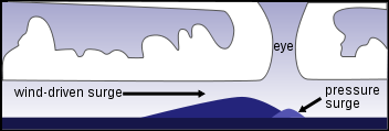
A storm surge
is an onshore gush of water associated with a low pressure weather system—storms. Storm surges can cause beach accretion and erosion. Historically notable storm surges occurred during the North Sea Flood of 1953
, Hurricane Katrina
, and the 1970 Bhola cyclone
.
, a wave-driven process by which sediments move along a beach shore, and other sources of erosion or accretion, such as nearby rivers.
are nourished by alluvial systems and accumulate sand
and silt
, growing where the sediment flux from land is large enough to avoid complete removal by coastal currents, tides, or waves.
Most modern deltas formed during the last five thousand years, after the present sea-level high stand was attained. However, not all sediment remains permanently in place: in the short term (decades to centuries), exceptional river floods, storms or other energetic events may remove significant portions of delta sediment or change its lobe distribution and, on longer geological time scales, sea-level fluctuations lead to destruction of deltaic features.
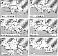 In the Mediterranean sea
, deltas have been continuously growing during for the last several thousand years. Six to seven thousand years ago, the sea level stabilized, and continuous river systems, ephemeral torrents, and other factors began this steady accretion. Since intense human use of coastal areas is a relatively recent phenomenon (except in the Nile
delta), beach contours were primarily shaped by natural forces until the last centuries.
In Barcelona
, for example, the accretion of the coast was a natural process until the late Middle Ages, when harbor
-building increased the rate of accretion
.
The port of Ephesus
, one of the great cities of the Ionian Greeks
in Asia Minor
, was filled with sediment due to accretion from a nearby river; it is now 5 kilometres (3.1 mi) from the sea. Likewise, Ostia
, the once-important port near ancient Rome, is now several kilometers inland, the coastline having moved slowly seaward.
Bruges
became a port during the early Middle Ages and was accessible by sea until around 1050. At that time, however, the natural link between Bruges and the sea silted up. In 1134, a storm flood opened a deep channel, the Zwin
, linking the city to the sea until the fifteenth century via a canal from the Zwin to Bruges. Bruges had to use a number of outports, such as Damme
and Sluis
, for this purpose. In 1907, a new seaport was inaugurated in Zeebrugge
.
At the present time important segments of low coasts are in recession, losing sand and reducing beach dimensions. This loss could can very rapidly. Examples of this are occurring at Sète
, in California, in Poland, in Aveiro (Portugal), and in Holland and elsewhere along the North Sea
. In Europe, coastal erosion is widespread (at least 70%) and distributed very irregularly.
 Volcanic activity can create new islands. The 800 metres (2,624.7 ft) in diameter Surtsey
Island, Iceland
, for example, was created between November 1963 and June 1967. The island has since partially eroded, but it is expected to last another 100 years.
Some earthquakes can create sudden variations of relative ground level and change the coastline dramatically. Structurally controlled coasts include the San Andreas fault
zone in California and the seismic Mediterranean belt (from Gibraltar to Greece).
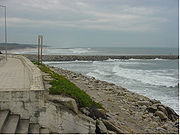
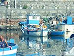
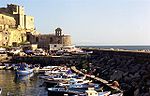
The Bay of Pozzuoli, in Pozzuoli
, Italy experienced hundreds of tremors between August 1982 and December 1984. The tremors, which reached a peak on October 4, 1983, damaged 8,000 buildings in the city center and raised the sea bottom by almost 2 metres (6.6 ft). This rendered the Bay of Pozzuoli
too shallow for large craft and required the reconstruction of the harbour with new quays. The photo at the upper right shows the harbor before the uplift while the one on the bottom right shows the new quay.
is the motion of the Earth's surface downward relative to the sea level due to internal geodynamic causes. The opposite of subsidence is uplift
, which increases elevation.
 Venice
is probably the best-known example of a subsiding location. It experiences periodic flooding when extreme hight tides or surges arrive. This phenomenon is caused by the compaction of young sediments in the Po River
delta area, magnified by subsurface water and gas exploitation. Man-made works to solve this progressive sinking have been unsuccessful.
Mälaren
, the third-largest lake in Sweden, is an example of deglacial uplift. It was once a bay on which seagoing vessels were once able to sail far into the country's interior, but it ultimately became a lake. Its uplift was caused by deglaciation: the removal of the weight of ice-age glaciers caused rapid uplift of the depressed land. For 2,000 years as the ice was unloaded, uplift proceeded at about 7.5 centimetres (3 in)/year. Once deglaciation was complete, uplift slowed to about 2.5 centimetre (0.984251968503937 in) annually, and it decreased exponentially after that. Today, annual uplift rates are 1 centimetre (0.393700787401575 in) or less, and studies suggest that rebound will continue for about another 10,000 years. The total uplift from the end of deglaciation may be up to 400 metres (1,312.3 ft).
Tsunami
A tsunami is a series of water waves caused by the displacement of a large volume of a body of water, typically an ocean or a large lake...
s, hurricanes and storm surge
Storm surge
A storm surge is an offshore rise of water associated with a low pressure weather system, typically tropical cyclones and strong extratropical cyclones. Storm surges are caused primarily by high winds pushing on the ocean's surface. The wind causes the water to pile up higher than the ordinary sea...
s accelerate beach erosion, potentially carrying away the entire sand load. Human activities can be as catastrophic as hurricanes, albeit usually over a longer time interval.
Extraordinary processes: tsunamis and hurricane-driven storm surges
Wave
In physics, a wave is a disturbance that travels through space and time, accompanied by the transfer of energy.Waves travel and the wave motion transfers energy from one point to another, often with no permanent displacement of the particles of the medium—that is, with little or no associated mass...
s often caused by earthquake
Earthquake
An earthquake is the result of a sudden release of energy in the Earth's crust that creates seismic waves. The seismicity, seismism or seismic activity of an area refers to the frequency, type and size of earthquakes experienced over a period of time...
s, have great erosion
Erosion
Erosion is when materials are removed from the surface and changed into something else. It only works by hydraulic actions and transport of solids in the natural environment, and leads to the deposition of these materials elsewhere...
al and sediment
Sediment
Sediment is naturally occurring material that is broken down by processes of weathering and erosion, and is subsequently transported by the action of fluids such as wind, water, or ice, and/or by the force of gravity acting on the particle itself....
-reworking potential. They may strip beaches of sand
Sand
Sand is a naturally occurring granular material composed of finely divided rock and mineral particles.The composition of sand is highly variable, depending on the local rock sources and conditions, but the most common constituent of sand in inland continental settings and non-tropical coastal...
that may have taken years to accumulate and may destroy trees and other coastal vegetation. Tsunamis are also capable of flooding hundreds of meters inland past the typical high-water level and fast-moving water, associated with the inundating tsunami, can crush homes and other coastal structures.
A storm surge
Storm surge
A storm surge is an offshore rise of water associated with a low pressure weather system, typically tropical cyclones and strong extratropical cyclones. Storm surges are caused primarily by high winds pushing on the ocean's surface. The wind causes the water to pile up higher than the ordinary sea...
is an onshore gush of water associated with a low pressure weather system—storms. Storm surges can cause beach accretion and erosion. Historically notable storm surges occurred during the North Sea Flood of 1953
North Sea flood of 1953
The 1953 North Sea flood was a major flood caused by a heavy storm, that occurred on the night of Saturday 31 January 1953 and morning of 1 February 1953. The floods struck the Netherlands, Belgium, England and Scotland.A combination of a high spring tide and a severe European windstorm caused a...
, Hurricane Katrina
Hurricane Katrina
Hurricane Katrina of the 2005 Atlantic hurricane season was a powerful Atlantic hurricane. It is the costliest natural disaster, as well as one of the five deadliest hurricanes, in the history of the United States. Among recorded Atlantic hurricanes, it was the sixth strongest overall...
, and the 1970 Bhola cyclone
1970 Bhola cyclone
The 1970 Bhola cyclone was a devastating tropical cyclone that struck East Pakistan and India's West Bengal on November 12, 1970. It was the deadliest tropical cyclone ever recorded, and one of the deadliest natural disasters in modern times...
.
Gradual processes
The gradual evolution of beaches often comes from the interaction of longshore driftLongshore drift
Longshore drift consists of the transportation of sediments along a coast at an angle to the shoreline, which is dependent on prevailing wind direction, swash and backwash. This process occurs in the littoral zone, and in or within close proximity to the surf zone...
, a wave-driven process by which sediments move along a beach shore, and other sources of erosion or accretion, such as nearby rivers.
Deltas
DeltasRiver delta
A delta is a landform that is formed at the mouth of a river where that river flows into an ocean, sea, estuary, lake, reservoir, flat arid area, or another river. Deltas are formed from the deposition of the sediment carried by the river as the flow leaves the mouth of the river...
are nourished by alluvial systems and accumulate sand
Sand
Sand is a naturally occurring granular material composed of finely divided rock and mineral particles.The composition of sand is highly variable, depending on the local rock sources and conditions, but the most common constituent of sand in inland continental settings and non-tropical coastal...
and silt
Silt
Silt is granular material of a size somewhere between sand and clay whose mineral origin is quartz and feldspar. Silt may occur as a soil or as suspended sediment in a surface water body...
, growing where the sediment flux from land is large enough to avoid complete removal by coastal currents, tides, or waves.
Most modern deltas formed during the last five thousand years, after the present sea-level high stand was attained. However, not all sediment remains permanently in place: in the short term (decades to centuries), exceptional river floods, storms or other energetic events may remove significant portions of delta sediment or change its lobe distribution and, on longer geological time scales, sea-level fluctuations lead to destruction of deltaic features.
Historical accretion of European beaches
Mediterranean Sea
The Mediterranean Sea is a sea connected to the Atlantic Ocean surrounded by the Mediterranean region and almost completely enclosed by land: on the north by Anatolia and Europe, on the south by North Africa, and on the east by the Levant...
, deltas have been continuously growing during for the last several thousand years. Six to seven thousand years ago, the sea level stabilized, and continuous river systems, ephemeral torrents, and other factors began this steady accretion. Since intense human use of coastal areas is a relatively recent phenomenon (except in the Nile
Nile
The Nile is a major north-flowing river in North Africa, generally regarded as the longest river in the world. It is long. It runs through the ten countries of Sudan, South Sudan, Burundi, Rwanda, Democratic Republic of the Congo, Tanzania, Kenya, Ethiopia, Uganda and Egypt.The Nile has two major...
delta), beach contours were primarily shaped by natural forces until the last centuries.
In Barcelona
Barcelona
Barcelona is the second largest city in Spain after Madrid, and the capital of Catalonia, with a population of 1,621,537 within its administrative limits on a land area of...
, for example, the accretion of the coast was a natural process until the late Middle Ages, when harbor
Harbor
A harbor or harbour , or haven, is a place where ships, boats, and barges can seek shelter from stormy weather, or else are stored for future use. Harbors can be natural or artificial...
-building increased the rate of accretion
Accretion (coastal management)
Accretion is the process of coastal sediment returning to the visible portion of a beach or foreshore following a submersion event. A sustainable beach or foreshore often goes through a cycle of submersion during rough weather then accretion during calmer periods...
.
The port of Ephesus
Ephesus
Ephesus was an ancient Greek city, and later a major Roman city, on the west coast of Asia Minor, near present-day Selçuk, Izmir Province, Turkey. It was one of the twelve cities of the Ionian League during the Classical Greek era...
, one of the great cities of the Ionian Greeks
Ancient Greece
Ancient Greece is a civilization belonging to a period of Greek history that lasted from the Archaic period of the 8th to 6th centuries BC to the end of antiquity. Immediately following this period was the beginning of the Early Middle Ages and the Byzantine era. Included in Ancient Greece is the...
in Asia Minor
Asia Minor
Asia Minor is a geographical location at the westernmost protrusion of Asia, also called Anatolia, and corresponds to the western two thirds of the Asian part of Turkey...
, was filled with sediment due to accretion from a nearby river; it is now 5 kilometres (3.1 mi) from the sea. Likewise, Ostia
Ostia Antica
Ostia Antica is a large archeological site, close to the modern suburb of Ostia , that was the location of the harbour city of ancient Rome, which is approximately 30 km to the northeast. "Ostia" in Latin means "mouth". At the mouth of the River Tiber, Ostia was Rome's seaport, but, due to...
, the once-important port near ancient Rome, is now several kilometers inland, the coastline having moved slowly seaward.
Bruges
Bruges
Bruges is the capital and largest city of the province of West Flanders in the Flemish Region of Belgium. It is located in the northwest of the country....
became a port during the early Middle Ages and was accessible by sea until around 1050. At that time, however, the natural link between Bruges and the sea silted up. In 1134, a storm flood opened a deep channel, the Zwin
Zwin
The Zwin is a nature reserve at the North Sea coast, on the Belgian-Dutch border. It consists of the entrace area of a former tidal inlet which during the Middle Ages connected the North Sea with the ports of Sluis and Bruges inland....
, linking the city to the sea until the fifteenth century via a canal from the Zwin to Bruges. Bruges had to use a number of outports, such as Damme
Damme
Damme is a municipality located in the Belgian province of West Flanders, six kilometres northeast of Brugge . The municipality comprises the city of Damme proper and the towns of Hoeke, Lapscheure, Moerkerke, Oostkerke, Sijsele, Vivenkapelle, and Sint-Rita. On 1 January 2006, the municipality had...
and Sluis
Sluis
Sluis is the name of both a municipality and a town located in the west of Zeelandic Flanders, in the south-western part of the Netherlands....
, for this purpose. In 1907, a new seaport was inaugurated in Zeebrugge
Zeebrugge
Zeebrugge is a village on the coast of Belgium and a subdivision of Bruges, for which it is the modern port. Zeebrugge serves as both the international port of Bruges-Zeebrugge and a seafront resort with hotels, cafés, a marina and a beach.-Location:...
.
Modern beach recession
At the present time important segments of low coasts are in recession, losing sand and reducing beach dimensions. This loss could can very rapidly. Examples of this are occurring at Sète
Sète
Sète is a commune in the Hérault department in Languedoc-Roussillon in southern France. Its inhabitants are called Sétois....
, in California, in Poland, in Aveiro (Portugal), and in Holland and elsewhere along the North Sea
North Sea
In the southwest, beyond the Straits of Dover, the North Sea becomes the English Channel connecting to the Atlantic Ocean. In the east, it connects to the Baltic Sea via the Skagerrak and Kattegat, narrow straits that separate Denmark from Norway and Sweden respectively...
. In Europe, coastal erosion is widespread (at least 70%) and distributed very irregularly.
Relative sea level changes
Several geological events and the climate can change (progressively or suddenly) the relative height of the Earth's surface to the sea-level. These events or processes continuously change coastlines.Vulcanism and Earthquakes
Surtsey
Surtsey is a volcanic island off the southern coast of Iceland. At it is also the southernmost point of Iceland. It was formed in a volcanic eruption which began 130 metres below sea level, and reached the surface on 15 November 1963. The eruption lasted until 5 June 1967, when the island...
Island, Iceland
Iceland
Iceland , described as the Republic of Iceland, is a Nordic and European island country in the North Atlantic Ocean, on the Mid-Atlantic Ridge. Iceland also refers to the main island of the country, which contains almost all the population and almost all the land area. The country has a population...
, for example, was created between November 1963 and June 1967. The island has since partially eroded, but it is expected to last another 100 years.
Some earthquakes can create sudden variations of relative ground level and change the coastline dramatically. Structurally controlled coasts include the San Andreas fault
San Andreas Fault
The San Andreas Fault is a continental strike-slip fault that runs a length of roughly through California in the United States. The fault's motion is right-lateral strike-slip...
zone in California and the seismic Mediterranean belt (from Gibraltar to Greece).
The Bay of Pozzuoli, in Pozzuoli
Pozzuoli
Pozzuoli is a city and comune of the province of Naples, in the Italian region of Campania. It is the main city of the Phlegrean peninsula.-History:Pozzuoli began as the Greek colony of Dicaearchia...
, Italy experienced hundreds of tremors between August 1982 and December 1984. The tremors, which reached a peak on October 4, 1983, damaged 8,000 buildings in the city center and raised the sea bottom by almost 2 metres (6.6 ft). This rendered the Bay of Pozzuoli
Pozzuoli
Pozzuoli is a city and comune of the province of Naples, in the Italian region of Campania. It is the main city of the Phlegrean peninsula.-History:Pozzuoli began as the Greek colony of Dicaearchia...
too shallow for large craft and required the reconstruction of the harbour with new quays. The photo at the upper right shows the harbor before the uplift while the one on the bottom right shows the new quay.
Gradual processes: subsidence and uplift
SubsidenceSubsidence
Subsidence is the motion of a surface as it shifts downward relative to a datum such as sea-level. The opposite of subsidence is uplift, which results in an increase in elevation...
is the motion of the Earth's surface downward relative to the sea level due to internal geodynamic causes. The opposite of subsidence is uplift
Tectonic uplift
Tectonic uplift is a geological process most often caused by plate tectonics which increases elevation. The opposite of uplift is subsidence, which results in a decrease in elevation. Uplift may be orogenic or isostatic.-Orogenic uplift:...
, which increases elevation.
Venice
Venice is a city in northern Italy which is renowned for the beauty of its setting, its architecture and its artworks. It is the capital of the Veneto region...
is probably the best-known example of a subsiding location. It experiences periodic flooding when extreme hight tides or surges arrive. This phenomenon is caused by the compaction of young sediments in the Po River
Po River
The Po |Ligurian]]: Bodincus or Bodencus) is a river that flows either or – considering the length of the Maira, a right bank tributary – eastward across northern Italy, from a spring seeping from a stony hillside at Pian del Re, a flat place at the head of the Val Po under the northwest face...
delta area, magnified by subsurface water and gas exploitation. Man-made works to solve this progressive sinking have been unsuccessful.
Mälaren
Mälaren
Lake Mälaren is the third-largest lake in Sweden, after Lakes Vänern and Vättern. Its area is 1,140 km² and its greatest depth is 64 m. Mälaren spans 120 kilometers from east to west...
, the third-largest lake in Sweden, is an example of deglacial uplift. It was once a bay on which seagoing vessels were once able to sail far into the country's interior, but it ultimately became a lake. Its uplift was caused by deglaciation: the removal of the weight of ice-age glaciers caused rapid uplift of the depressed land. For 2,000 years as the ice was unloaded, uplift proceeded at about 7.5 centimetres (3 in)/year. Once deglaciation was complete, uplift slowed to about 2.5 centimetre (0.984251968503937 in) annually, and it decreased exponentially after that. Today, annual uplift rates are 1 centimetre (0.393700787401575 in) or less, and studies suggest that rebound will continue for about another 10,000 years. The total uplift from the end of deglaciation may be up to 400 metres (1,312.3 ft).
See also
- Coastal managementCoastal managementIn some jurisdictions the terms sea defense and coastal protection are used to mean, respectively, defense against flooding and erosion...
- Coastal erosionCoastal erosionCoastal erosion is the wearing away of land and the removal of beach or dune sediments by wave action, tidal currents, wave currents, or drainage...
- Longshore driftLongshore driftLongshore drift consists of the transportation of sediments along a coast at an angle to the shoreline, which is dependent on prevailing wind direction, swash and backwash. This process occurs in the littoral zone, and in or within close proximity to the surf zone...
- Coastal geographyCoastal geographyCoastal geography is the study of the dynamic interface between the ocean and the land, incorporating both the physical geography and the human geography of the coast...
- Strand plainStrand plainA strand plain or strandplain is a broad belt of sand along a shoreline with a surface exhibiting well-defined parallel or semi-parallel sand ridges separated by shallow swales. A strandplain differs from a barrier island in that it lacks either the lagoons or tidales marsh that separate a...
- Sand dune stabilizationSand dune stabilizationSand dunes are common features of shoreline and desert environments. Dunes provide habitat for highly specialized plants and animals, including rare and endangered species. They can protect beaches from erosion and recruit sand to eroded beaches. Dunes are threatened by human activity, both...