

Coastal geography
Encyclopedia
Coastal geography is the study of the dynamic interface between the ocean and the land, incorporating both the physical geography
(i.e coastal geomorphology
, geology
and oceanography
) and the human geography
(sociology
and history
) of the coast. It involves an understanding of coastal weathering processes, particularly wave action, sediment movement and weather, and also the ways in which humans interact with the coast.
Coastal geography is that branch of geography, incorporating physical and human geography,which deals with the study of the dynamic interface between ocean and land.
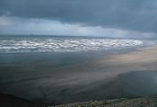
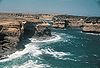 The waves of different strengths that constantly hit against the shoreline are the primary movers and shapers of the coastline. Despite the simplicity of this process, the differences between waves and the rocks they hit result in hugely varying shapes.
The effect that waves have depends on their strength. Strong, also called destructive waves occur on high energy beaches and are typical of Winter. They reduce the quantity of sediment present on the beach by carrying it out to bars under the sea. Constructive, weak waves are typical of low energy beaches and occur most during summer. They do the opposite to destructive waves and increase the size of the beach by piling sediment up onto the berm.
One of the most important transport mechanisms results from wave refraction. Since waves rarely break onto a shore at right angles, the upward movement of water onto the beach
(swash) occurs at an oblique angle. However, the return of water (backwash) is at right angles to the beach, resulting in the net movement of beach material laterally. This movement is known as beach drift (Figure 3). The endless cycle of swash and backwash and resulting beach drift can be observed on all beaches.
 Probably the most important effect is longshore drift
(LSD)(Also known as Littoral Drift), the process by which sediment is continuously moved along beaches by wave action. LSD occurs because waves hit the shore at an angle, pick up sediment (sand) on the shore and carry it down the beach at an angle (this is called swash). Due to gravity, the water then falls back perpendicular to the beach, dropping its sediment as it loses energy (this is called backwash). The sediment is then picked up by the next wave and pushed slightly further down the beach, resulting in a continual movement of sediment in one direction. This is the reason why long strips of coast are covered in sediment, not just the areas around river mouths, which are the main sources of beach sediment. LSD is reliant on a constant supply of sediment from rivers and if sediment supply is stopped or sediment falls into a submarine canals at any point along a beach, this can lead to bare beaches further along the shore.
LSD helps create many landforms including barriers
, bay beaches and spits
. In general LSD action serves to straighten the coast because the creation of barriers cuts off bays
from the sea while sediment usually builds up in bays because the waves there are weaker (due to wave refraction), while sediment is carried away from the exposed headlands
. The lack of sediment on headlands removes the protection of waves from them and makes them more vulnerable to weathering while the gathering of sediment in bays (where longshore drift is unable to remove it) protects the bays from further erosion and makes them pleasant recreational beaches.
and clay
.
In some beaches calcium carbonate is able to bind together other sediments to form beachrock
and in warmer areas dunerock.
ice age they were quite low. Global warming
may result in further rises in the future, which presents a risk to coastal cities as most would be flooded by only small rises. As sea levels rise fjords and rias
form. Fjords are flooded glacial valleys and rias are flooded river valleys. Fjords typically have steep rocky sides, while rias have dendritic drainage patterns typical of drainage zones.
As tectonic plates
move about the Earth they can rise and fall due to changing pressures and the presence of glaciers. If a beach is moving upwards relative to other plates this is known as isostatic change and raised beaches can be formed.
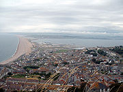 If the coast suddenly changes direction, especially around an estuary, spits are likely to form. Long shore drift pushes sediment along the beach but when it reaches a turn as in the diagram, the long shore drift does not always easily turn with it, especially near an estuary where the outward flow from a river may push sediment away from the coast. The area may be also be shielded from wave action, preventing much long shore drift. On the side of the headland receiving weaker waves, shingle and other large sediments will build up under the water where waves are not strong enough to move them along. This provides a good place for smaller sediments to build up to sea level. The sediment, after passing the headland will accumulate on the other side and not continue down the beach, sheltered both by the headland and the shingle.
Slowly over time sediment simply builds on this area, extending the spit outwards, forming a barrier of sand. Once in a while, the wind direction will change and come from the other direction. During this period the sediment will be pushed along in the other direction. The spit will start to grow backwards, forming a 'hook'. After this time the spit will grow again in the original direction. Eventually the spit will not be able to grow any further because it is no longer sufficiently sheltered from erosion by waves, or because the estuary current prevents sediment resting. Usually in the salty but calm waters behind the spit there will form a salt marshland. Spits often form around the breakwater of artificial harbours requiring dredging.
Occasionally, if there is no estuary then it is possible for the spit to grow across to the other side of the bay and form what is called a bar, or barrier. Barriers come in several varieties, but all form in a manner similar to spits. They usually enclose a bay to form a lagoon. They can join two headlands or join a headland to the mainland. When an island is joined to the mainland with a bar or barrier it is known as a tombolo. This usually occurs due to wave refraction, but can also be caused by isostatic change, a change in the level of the land (e.g. Chesil Beach
). An example of this is along the Holderness
coastline.
Physical geography
Physical geography is one of the two major subfields of geography. Physical geography is that branch of natural science which deals with the study of processes and patterns in the natural environment like the atmosphere, biosphere and geosphere, as opposed to the cultural or built environment, the...
(i.e coastal geomorphology
Geomorphology
Geomorphology is the scientific study of landforms and the processes that shape them...
, geology
Geology
Geology is the science comprising the study of solid Earth, the rocks of which it is composed, and the processes by which it evolves. Geology gives insight into the history of the Earth, as it provides the primary evidence for plate tectonics, the evolutionary history of life, and past climates...
and oceanography
Oceanography
Oceanography , also called oceanology or marine science, is the branch of Earth science that studies the ocean...
) and the human geography
Human geography
Human geography is one of the two major sub-fields of the discipline of geography. Human geography is the study of the world, its people, communities, and cultures. Human geography differs from physical geography mainly in that it has a greater focus on studying human activities and is more...
(sociology
Sociology
Sociology is the study of society. It is a social science—a term with which it is sometimes synonymous—which uses various methods of empirical investigation and critical analysis to develop a body of knowledge about human social activity...
and history
History
History is the discovery, collection, organization, and presentation of information about past events. History can also mean the period of time after writing was invented. Scholars who write about history are called historians...
) of the coast. It involves an understanding of coastal weathering processes, particularly wave action, sediment movement and weather, and also the ways in which humans interact with the coast.
Coastal geography is that branch of geography, incorporating physical and human geography,which deals with the study of the dynamic interface between ocean and land.
Wave action and longshore drift
The effect that waves have depends on their strength. Strong, also called destructive waves occur on high energy beaches and are typical of Winter. They reduce the quantity of sediment present on the beach by carrying it out to bars under the sea. Constructive, weak waves are typical of low energy beaches and occur most during summer. They do the opposite to destructive waves and increase the size of the beach by piling sediment up onto the berm.
One of the most important transport mechanisms results from wave refraction. Since waves rarely break onto a shore at right angles, the upward movement of water onto the beach
Beach
A beach is a geological landform along the shoreline of an ocean, sea, lake or river. It usually consists of loose particles which are often composed of rock, such as sand, gravel, shingle, pebbles or cobblestones...
(swash) occurs at an oblique angle. However, the return of water (backwash) is at right angles to the beach, resulting in the net movement of beach material laterally. This movement is known as beach drift (Figure 3). The endless cycle of swash and backwash and resulting beach drift can be observed on all beaches.
Longshore drift
Longshore drift consists of the transportation of sediments along a coast at an angle to the shoreline, which is dependent on prevailing wind direction, swash and backwash. This process occurs in the littoral zone, and in or within close proximity to the surf zone...
(LSD)(Also known as Littoral Drift), the process by which sediment is continuously moved along beaches by wave action. LSD occurs because waves hit the shore at an angle, pick up sediment (sand) on the shore and carry it down the beach at an angle (this is called swash). Due to gravity, the water then falls back perpendicular to the beach, dropping its sediment as it loses energy (this is called backwash). The sediment is then picked up by the next wave and pushed slightly further down the beach, resulting in a continual movement of sediment in one direction. This is the reason why long strips of coast are covered in sediment, not just the areas around river mouths, which are the main sources of beach sediment. LSD is reliant on a constant supply of sediment from rivers and if sediment supply is stopped or sediment falls into a submarine canals at any point along a beach, this can lead to bare beaches further along the shore.
LSD helps create many landforms including barriers
Barriers
Barriers is a British children's television series, created and written by William Corlett, and made by Tyne Tees Television for ITV between 1981 and 1982....
, bay beaches and spits
Spit (landform)
A spit or sandspit is a deposition landform found off coasts. At one end, spits connect to land, and extend into the sea. A spit is a type of bar or beach that develops where a re-entrant occurs, such as at cove's headlands, by the process of longshore drift...
. In general LSD action serves to straighten the coast because the creation of barriers cuts off bays
Headlands and bays
Headlands and bays are two related features of the coastal environment.- Geology and geography :Headlands and bays are often found on the same coastline. A bay is surrounded by land on three sides, whereas a headland is surrounded by water on three sides. Headlands are characterized by high,...
from the sea while sediment usually builds up in bays because the waves there are weaker (due to wave refraction), while sediment is carried away from the exposed headlands
Headlands and bays
Headlands and bays are two related features of the coastal environment.- Geology and geography :Headlands and bays are often found on the same coastline. A bay is surrounded by land on three sides, whereas a headland is surrounded by water on three sides. Headlands are characterized by high,...
. The lack of sediment on headlands removes the protection of waves from them and makes them more vulnerable to weathering while the gathering of sediment in bays (where longshore drift is unable to remove it) protects the bays from further erosion and makes them pleasant recreational beaches.
Atmospheric processes
- Onshore winds blowing "up" the beach, pick up sand and move it up the beach to form sand dunes.
- Rain hits the shore and erodes rocks, and carries weathered material to the shoreline to form beaches.
- Warm weather can encourage biological processes to occur more rapidly. In tropical areas some plants and animals protect stones from weathering, while other plants and animals actually eat away at the rocks.
- Temperatures that vary from below to above freezing point result in freeze-thaw weathering, while weather more than a few degrees below freezing point creates sea ice.
Biological processes
In tropical regions in particular, plants and animals not only affect the weathering of rocks but are a source of sediment themselves. The shells and skeletons of many organisms are of calcium carbonate and when this is broken down it forms sediment, limestoneLimestone
Limestone is a sedimentary rock composed largely of the minerals calcite and aragonite, which are different crystal forms of calcium carbonate . Many limestones are composed from skeletal fragments of marine organisms such as coral or foraminifera....
and clay
Clay
Clay is a general term including many combinations of one or more clay minerals with traces of metal oxides and organic matter. Geologic clay deposits are mostly composed of phyllosilicate minerals containing variable amounts of water trapped in the mineral structure.- Formation :Clay minerals...
.
Physical processes
The main Physical Weathering process on beaches is salt-crystal growth. Wind carries salt spray onto rocks, where it is absorbed into small pores and cracks within the rocks. There the water evaporates and the salt crystallises, creating pressure and often breaking down the rock.In some beaches calcium carbonate is able to bind together other sediments to form beachrock
Beachrock
Beachrock is a friable to well-cemented sedimentary rock that consists of a variable mixture of gravel-, sand-, and silt-sized sediment that is cemented with carbonate minerals and has formed along a shoreline...
and in warmer areas dunerock.
Sea level changes (Eustatic Change)
Because the sea level on earth regularly rises and falls due to climatic changes. During cold periods more of the Earth’s water is stored as ice in glaciers while during warm periods it is released and sea levels rise to cover more land. Sea levels are currently quite high, while just 18,000 years ago during the PleistocenePleistocene
The Pleistocene is the epoch from 2,588,000 to 11,700 years BP that spans the world's recent period of repeated glaciations. The name pleistocene is derived from the Greek and ....
ice age they were quite low. Global warming
Global warming
Global warming refers to the rising average temperature of Earth's atmosphere and oceans and its projected continuation. In the last 100 years, Earth's average surface temperature increased by about with about two thirds of the increase occurring over just the last three decades...
may result in further rises in the future, which presents a risk to coastal cities as most would be flooded by only small rises. As sea levels rise fjords and rias
RIAS
RIAS can stand for one of the following:*Rias, the plural of Ria, a lower river valley submerged by the sea*"Research Institute for Advanced Study", the former research facility created by the Glenn L...
form. Fjords are flooded glacial valleys and rias are flooded river valleys. Fjords typically have steep rocky sides, while rias have dendritic drainage patterns typical of drainage zones.
As tectonic plates
Tectonic Plates
Tectonic Plates is a 1992 independent Canadian film directed by Peter Mettler. Mettler also wrote the screenplay based on the play by Robert Lepage. The film stars Marie Gignac, Céline Bonnier and Robert Lepage.-Plot summary:...
move about the Earth they can rise and fall due to changing pressures and the presence of glaciers. If a beach is moving upwards relative to other plates this is known as isostatic change and raised beaches can be formed.
Land level changes (Isostatic Change)
This is found in the U.K. as above the line from the Wash to the Severn estuary, the land was covered in ice sheets during the last ice age. The weight of the ice caused northeast Scotland to sink, displacing the southeast and forcing it to rise. As the ice sheets receded the reverse process happened, as the land was released from the weight. At current estimates the southeast is sinking at a rate of about 2 mm per year, with northeast Scotland rising by the same amount.Spits
Slowly over time sediment simply builds on this area, extending the spit outwards, forming a barrier of sand. Once in a while, the wind direction will change and come from the other direction. During this period the sediment will be pushed along in the other direction. The spit will start to grow backwards, forming a 'hook'. After this time the spit will grow again in the original direction. Eventually the spit will not be able to grow any further because it is no longer sufficiently sheltered from erosion by waves, or because the estuary current prevents sediment resting. Usually in the salty but calm waters behind the spit there will form a salt marshland. Spits often form around the breakwater of artificial harbours requiring dredging.
Occasionally, if there is no estuary then it is possible for the spit to grow across to the other side of the bay and form what is called a bar, or barrier. Barriers come in several varieties, but all form in a manner similar to spits. They usually enclose a bay to form a lagoon. They can join two headlands or join a headland to the mainland. When an island is joined to the mainland with a bar or barrier it is known as a tombolo. This usually occurs due to wave refraction, but can also be caused by isostatic change, a change in the level of the land (e.g. Chesil Beach
Chesil Beach
Chesil Beach, sometimes called Chesil Bank, in Dorset, southern England is one of three major shingle structures in Britain. Its toponym is derived from the Old English ceosel or cisel, meaning "gravel" or "shingle"....
). An example of this is along the Holderness
Holderness
Holderness is an area of the East Riding of Yorkshire, on the east coast of England. An area of rich agricultural land, Holderness was marshland until it was drained in the Middle Ages. Topographically, Holderness has more in common with the Netherlands than other parts of Yorkshire...
coastline.