

Church Stretton
Encyclopedia
Church Stretton is a small town and civil parish in Shropshire
, England. The population of the town was recorded as 2,789 in 2001, whilst the population of the wider parish (including the adjacent settlements of All Stretton
and Little Stretton
) was recorded as 4,186. The town lies entirely in the Shropshire Hills
AONB
, on the A49 road
approximately 13 miles (21 km) south of Shrewsbury
, the county town
, and 15 miles (24 km) north of Ludlow
.
The area has been settled since the Iron Age
, during which a hillfort was constructed on Caer Caradoc hill. The town was nicknamed Little Switzerland
during the Victorian
and Edwardian periods, due to its landscape and development as a health resort. The local geology is complex and incorporates some of the oldest rocks in England - a notable fault is named after the town. Today Church Stretton is a market town
as well as being a destination for visitors to the surrounding natural landscape, with the Long Mynd
situated on the western side of the town.
hillfort on Caer Caradoc
overlooks the town. The name "Stretton" is derived from the Old English words stræt meaning "Roman Road" and tun meaning "settlement"; a Roman road
, Watling Street
runs through the Stretton valley, though the town (and adjacent settlements) were not historically located on this road — during the "Dark Ages" the settlements grew a short distance away from the old thoroughfare, for defensive purposes. Today the modern A49 road, which was constructed on its current alignment through the Stretton Gap in the late 1930s, runs along a similar course to the Roman Road.
The town was granted a market charter by King John
in 1214, and the market is still held every Thursday and Saturday, in the square on the High Street. Much of the town centre was destroyed by fire in 1593 and many of the present half timbered
buildings in the town centre date from the time of the rebuilding.
The High Street was for many centuries known instead as the Bristol Road, being the road from Shrewsbury to Bristol
. It was once a much wider street within the town, with the churchyard of St Laurence bordering directly onto the street. Over time buildings were erected on the street, in a similar fashion to other English market towns, such as in Ludlow. The High Street, which is a narrow street, is effectively only the eastern side of the original Bristol Road thoroughfare through the town. It was made more open when the old market hall was demolished to form the present town square.
. Historically the town was known for its textiles, specifically in Carding Mill Valley. Carding Mill was built in the 18th century, and named after a stage in making cloth, the three stages being carding
, spinning
and weaving
. Carding would have been done by children, and involved using a hand-card that removed and untangled short fibres from the mass of raw material. The cards were wooden blocks with handles and covered in metal spikes, which were angled, (to make it easier to untangle) and set in leather. When untangled, the material would be spun, and then weaved into the final product.
The carding mill closed at the beginning of the 20th century. The mill is still in the valley today, but has been converted into luxury flats. The valley it was in took the name "Carding Mill Valley", and is now a tourist attraction owned by the National Trust
.
" during its growth in the late Victorian and Edwardian periods, because of the way many houses hug the hillside, the surrounding mountainous landscape, and because the town is said to have been run like clockwork.
Church Stretton railway station
opened on 20 April 1852 as part of the newly created Shrewsbury and Hereford Railway
. It was originally situated to the north of (what is now known as) Sandford Avenue and the old station building still remains, but is no longer in railway use. Sandford Avenue had been for centuries called Lake Lane and became Station Road with the arrival of the railway in the town, before becoming Sandford Avenue in 1884.
In 1914 the station was relocated just to the south of the Sandford Avenue road bridge, where it continues to the present day. New station buildings were erected, but these were demolished in 1970, the station having become unstaffed in 1967.
The Long Mynd Hotel on Cunnery Road was built in 1900 , originally as the Hydro, at a time when the town was popular as a spa. Today it continues as a hotel and has its own swimming pool and woodland trails; it is a wedding and conference venue.
Local property developer Ralph Beaumont Benson (1862–1911), who lived at Lutwyche Hall in nearby Easthope
, is responsible for the naming of Easthope Road, Essex Road (after his wife), Beaumont Road and Lutwyche Road, all in the centre of the town and part of the town's expansion in the early 20th century.
was based in the town. The charitable service (for blinded armed forces personnel) was relocated from Sussex
as Church Stretton was thought to be a safe location. Some 700 people were trained during this period in Church Stretton. The Long Mynd Hotel, the Brockhurst Estate, and Tiger Hall were the most notable buildings taken over by St Dunstan's in the town. A residential cul-de-sac is named St Dunstan's Close in recognition of the charity's place in the town's history. Although Church Stretton avoided the aerial bombing of the war, the Long Mynd was considered to be a potential landing place for German parachutists.
stood on the High Street but was demolished in July 1963 and the site has become a town square
, and is still used to hold markets on. The first market hall — a timber-framed construction — was built in 1617; this was replaced by the second market hall (called the Town Hall) in 1839, which was a stone and red-brick construction. Today the Silvester Horne Institute (extended and refurbished in 2011) is the town's main meeting place for societies, public meetings & exhibitions and polling
, and the town council have their offices nearby on the High Street. Additionally there is the Mayfair Community Centre on Easthope Road and the St Laurence's Parish Hall on Church Street.
 Church Stretton is located approximately 13 miles (21 km) south of Shropshire's county town, Shrewsbury
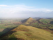
. The town is dominated by the surrounding hills, including the huge Long Mynd
massif to the west, and Caer Caradoc Hill
and the adjacent hills (Hazler, Ragleth, et al.) to the east.
Church Stretton effectively lies at a saddle point
- the railway station lies roughly at this position, which is at 187m above sea level. The High Street through the town centre runs at an elevation
of 194 to 195m. Because of its position at a saddle point, water drains away from the town in two directions - to the north (to the Cound
and then the Severn
) and to the south (to the Onny
and then the Teme
) - roughly Sandford Avenue in the town centre forms the watershed. Parts of the town are subject to flooding after heavy rain and in 2000 serious flooding closed the railway line through the town.
are the High Street and Sandford Avenue.
Cunnery is a hillside and collection of houses to the west of the town centre and includes the Long Mynd Hotel. World's End is where the Ludlow Road curves round the foot of the hillside to the south of the Long Mynd Hotel. To the north of the town centre is an area called Ashbrook; here the Carding Mill Valley meets the town, with the stream (known as the Ashbrook as it runs through the town) running between the town's two main recreation fields (named Russell's Meadow and Richard Robinson Field). Two other notable areas of public parkland are Rectory Field & Wood, situated to the west of the town centre off Church Street, and the town's formal park between the A49 and the railway line, which is managed by the town council and includes tennis courts and a bowling green.
On the eastern side of the A49 road are the areas of Battle Field (or Battlefield) and Hazler; on Hazler Hill is a transmitter
for local radio (BBC
Radio Shropshire broadcast from here on 90FM). Battle Field is named for the legend that Caer Caradoc was the site of the last stand of Caractacus against the Roman legions during the Roman conquest of Britain, and that after the battle
he hid in the cave near its summit.
, which also manages the neighbouring villages of All Stretton
, Little Stretton
, and the hamlets of Minton
and Hamperley
. At the 2001 census, the parish's population was 4,186. The parish is divided into four wards: Church Stretton North (represented by four councillors on the town council), Church Stretton South (represented by five councillors), All Stretton and Little Stretton (each represented by two councillors).
Sometimes the parish is referred to as "Church Stretton and Little Stretton"; the parish was formed from the merger of the former Little Stretton and Church Stretton parishes, together with part of All Stretton parish (the remainder still exists as a separate parish).
Church Stretton is part of the Shropshire Council
electoral division
of Church Stretton and Craven Arms.
On a national level, Church Stretton is located within the Ludlow constituency
, and the current MP for that constituency is Philip Dunne
, a Conservative
MP.
-Linley
Fault - registered an earthquake
with a magnitude of 5.1 on the Richter scale
, known as the Bishop's Castle earthquake
. The area also plays a part in the history of geology: the three major subdivsions of the Lower Paleozoic
are named for local celt
ic tribes - Cambrian
, Ordovician
& Silurian
. Also, Comley
Quarry is about 2.5 miles (4 km) from the town and the first site in the British Isles where trilobite
s were recorded.
runs through the Stretton valley, from Shrewsbury in the north towards Ludlow
and Hereford
to the south. The B5477 runs through the villages of All Stretton and Little Stretton, as well as the historic core and town centre of Church Stretton. The B4371 starts at the B5477 in the town centre and heads east, having a crossroads junction with the A49, then up to Hazler and on towards Much Wenlock
. The B4371 in the town (on both sides of the A49) is known as Sandford Avenue and is partially lined with lime trees.
The B5477 was, until renumbered in 2004, the northern section of the B4370. The renumbering to B5477 is inexplicable in two ways - the number does not comply with the Great Britain road numbering scheme
(it is "out-of-zone") and is already in use in Wallasey
.
The Welsh Marches Line
runs through the town and there is a station
, situated off Sandford Avenue just east of the town centre, near the junction of the A49 and B4371. The railway was originally built as the Shrewsbury and Hereford Railway
in 1852. Trains on the Heart of Wales Line
also call at the station. Today there are direct train services to Shrewsbury, Chester
, Holyhead
, Crewe
, Manchester
, Ludlow
, Hereford
, Newport
, Cardiff
and Swansea
.
The town is served by the 435 bus route (the Shrewsbury-Ludlow service), run by Minsterley Motors
, which runs Monday-Saturday. This connects the town with All Stretton, Dorrington
and Condover
towards Shrewsbury, and Little Stretton, Craven Arms and Bromfield
towards Ludlow. In addition there is a Shropshire Hills Shuttles service (route 780) that operates during the spring/summer, which runs over the Long Mynd to Ratlinghope
& Bridges, Stiperstones
, Habberley
, Pulverbatch, Minsterley
and Pontesbury
. This operates at the weekends and on Bank Holiday
Mondays.
Regional Cycle Route 32/33 runs through the town, on its way from Shrewsbury to Craven Arms. The route avoids cycling along the busy A49 main road, with the exception of a stretch north of Craven Arms.
: a secondary school with 750 pupils and a primary school (named "St Lawrence") with 210 pupils. The two schools neighbour one other and are situated just off Shrewsbury Road, on the northern edge of Church Stretton. The Council also operates a public library, on Church Street, situated in former, Victorian school buildings, which is also the town's visitor centre.
bottling plant on Shrewsbury Road is a notable local employer. Another notable employer is the technology laboratories off Essex Road, currently owned by Agilent Technologies
(until 2009 by Varian
). There is a designated industrial estate/business park area between the A49 and the railway line, with a number of small businesses operating.
The town benefits from tourism, which is a growth industry in the area, as well as attracting local trade. A recent survey showed that the town has some fifty retail outlets, 44 of which are independently-owned, with a high diversity of shop types. The offer in the town centre includes two butchers, several outdoor activities shops, bakers and delicatessens, several clothes and shoe shops, three banks, and a Co-op
supermarket. There is a large antiques
market, situated in a former malthouse
on the corner of Sandford Avenue and Easthope Road. There are four pubs
, as well as a number of cafes and small restaurants. In June 2011 the town was officially declared to be a "Fairtrade Town
" with 34 businesses selling fair trade products. A small art gallery exists in the former hotel on the corner of Shrewsbury Road and Sandford Avenue. The town also has a number of professional services, such as solicitors, accountants and estate agents, confirming its status as a local centre of business.
As of the 2001 census, in the north ward of Church Stretton, 50.6% of residents are in employment, and 32.2% are retired
; unemployment
is at 2%. In Church Stretton's south ward, the rate of employment is higher, at 57.5%, with 24.9% of residents retired; the rate of unemployment is 1.9%.
 The novelist Henry Kingsley
(1830–1876) wrote "Stretton" based around this area, and Oliver Sandys' book, "Quaint Place" is set in Church Stretton. Mary Webb
's works also made reference to the town, under the name "Shepwardine". The Lone Pine Club series of children's books by Malcolm Saville
is also partly set in the area.
Church Stretton is a major centre for the sport of archery
, and there is also a gliding air field and station atop the Long Mynd, owned by the Midland Gliding Club. As well as gliding
, the activities of paragliding
, hang gliding
and similar aerial pursuits take place from the Long Mynd. In the town itself, sports facilities are provided adjacent to the schools, just off Shrewsbury Road, which include a swimming pool and fitness centre, and the town council provide facilities (such as tennis courts, a bowling green and a croquet pitch) at the town park.
and steam
rally. In the evening there is a concert in Rectory Field.
on Ludlow Road; a Roman Catholic church dedicated to St Milburga (a local saint), situated on the corner of Sandford Avenue and Watling Street; and a Methodist church situated on the corner of Crossways and Watling Street.
 There is a 18-hole golf course
about a km from the town centre, the Church Stretton Golf Club. The course is 5,030 yards long and has a par of 66. It is one of the highest golf courses in the country, being located on the side of the Long Mynd
hill range (the course is situated on the slopes of Stanyeld Hill and Bodbury Hill). The clubhouse is at approximately 230m (755 ft) above sea level and the hilly links
course rises up to around 375m (1,230 ft). Apart from the clubhouse, putting green and first hole, the course is situated on common land
owned by the National Trust
(who own most of the Long Mynd
upland area).
The town's golf course is the oldest 18-hole course in Shropshire, with the club starting in 1898 and the final holes being completed around 1904. The course was primarily designed by John (Jack) Morris and James Hepburn. James Braid
and Harry Vardon
later made changes to the course.
Open Champions
James Braid, Harry Vardon and J. H. Taylor
(together referred to as the Great Triumvirate
) all played at the course many times, albeit at different times, during the pre-World War I years of the club's existence.
's Premier Division. Home games are played at Russell's Meadow, located near the centre of the town off Lutwyche Road . In the 2009-10 season, Church Stretton were winners of the Sentinel News First Division Cup, convincingly beating Brown Clee 5-1 in the final. In the 2010-11 season, Church Stretton finished 2nd in Division One, gaining promotion to the Premier Division for 2011-12. Having completed the season, the side then won the SFA
Williams & Picken Junior Cup, beating Premier Division side Ellesmere Rangers Reserves at Shrewsbury Town's ground, the New Meadow
.
There has been a football field at Russell's Meadow since the 1930s, though the pavilion moved (c. 1950s) from the other side of the Ashbrook to its present location near Lutwyche Road. There is a community project on-going to raise funds and then build a new pavilion at Russell's Meadow. A number of junior teams play at Russell's Meadow whilst during the summer the Meadow and its pavilion are used to play cricket
.
, who used to live in Minton, near Little Stretton, which was the home of Oliver Sandys. Also, the Olympic bronze-medal archer, Alison Williamson
lives in All Stretton. In the 1930s, E. M. Almedingen
, the biographer and children's writer, lived in the town, and, following retirement, the writer Kenneth Bird moved to Church Stretton.
The 'White House' nursing home
on Sandford Avenue was demolished in 2006 to make way for a housing development, and it was previously the family home of Charles Silvester Horne
a congregationalist minister, Liberal
MP for Ipswich
, and father of the BBC broadcaster Kenneth Horne
. The town's Silvester Horne Institute, on Ludlow Road, commemorates his name.
Hesba Stretton
came to Church Stretton often before moving away from Shropshire, becoming an established author. There is a plaque to her memory in St. Laurence's Church together with a window depicting the figure of "Jessica" from her immensely popular story Jessica's First Prayer.
Stephen Laurie
, a notable amateur astronomer
, lives in the area and has discovered a number of asteroid
s from observatories at Church Stretton and nearby Ragdon (the area not suffering from much light pollution
). One of the asteroids discovered has been named after the town — 11626 Church Stretton
.
Shropshire
Shropshire is a county in the West Midlands region of England. For Eurostat purposes, the county is a NUTS 3 region and is one of four counties or unitary districts that comprise the "Shropshire and Staffordshire" NUTS 2 region. It borders Wales to the west...
, England. The population of the town was recorded as 2,789 in 2001, whilst the population of the wider parish (including the adjacent settlements of All Stretton
All Stretton
All Stretton is a village and civil parish in Shropshire, England.-Geography:All Stretton lies about a mile to the north of the market town of Church Stretton, on the old Shrewsbury Road - the county town is 12 miles to the north. Similarly, the small village of Little Stretton lies to the south...
and Little Stretton
Little Stretton, Shropshire
Little Stretton is a village in Shropshire, England.It lies on the B5477 to the south of the town of Church Stretton ; similarly, the small village of All Stretton lies to the north of Church Stretton on the same road...
) was recorded as 4,186. The town lies entirely in the Shropshire Hills
Shropshire Hills AONB
The Shropshire Hills area is designated as an Area of Outstanding Natural Beauty , in the English county of Shropshire, close to its border with Wales. Designated in 1958 , the area encompasses of land primarily in south-west Shropshire...
AONB
Area of Outstanding Natural Beauty
An Area of Outstanding Natural Beauty is an area of countryside considered to have significant landscape value in England, Wales or Northern Ireland, that has been specially designated by the Countryside Agency on behalf of the United Kingdom government; the Countryside Council for Wales on...
, on the A49 road
A49 road
The A49 is a major road in western England, which traverses the Welsh Marches region. It runs north from Ross-on-Wye in Herefordshire via Hereford, Leominster, Ludlow, Shrewsbury and Whitchurch, then continues through central Cheshire to Warrington and Wigan before terminating at its junction with...
approximately 13 miles (21 km) south of Shrewsbury
Shrewsbury
Shrewsbury is the county town of Shropshire, in the West Midlands region of England. Lying on the River Severn, it is a civil parish home to some 70,000 inhabitants, and is the primary settlement and headquarters of Shropshire Council...
, the county town
County town
A county town is a county's administrative centre in the United Kingdom or Ireland. County towns are usually the location of administrative or judicial functions, or established over time as the de facto main town of a county. The concept of a county town eventually became detached from its...
, and 15 miles (24 km) north of Ludlow
Ludlow
Ludlow is a market town in Shropshire, England close to the Welsh border and in the Welsh Marches. It lies within a bend of the River Teme, on its eastern bank, forming an area of and centred on a small hill. Atop this hill is the site of Ludlow Castle and the market place...
.
The area has been settled since the Iron Age
Iron Age
The Iron Age is the archaeological period generally occurring after the Bronze Age, marked by the prevalent use of iron. The early period of the age is characterized by the widespread use of iron or steel. The adoption of such material coincided with other changes in society, including differing...
, during which a hillfort was constructed on Caer Caradoc hill. The town was nicknamed Little Switzerland
Little Switzerland (landscape)
A little Switzerland or Schweiz is a landscape, often of wooded hills. This Romantic aesthetic term is not a geographic category, but was widely used in the 19th century to connote dramatic natural scenic features that would be of interest to tourists...
during the Victorian
Victorian era
The Victorian era of British history was the period of Queen Victoria's reign from 20 June 1837 until her death on 22 January 1901. It was a long period of peace, prosperity, refined sensibilities and national self-confidence...
and Edwardian periods, due to its landscape and development as a health resort. The local geology is complex and incorporates some of the oldest rocks in England - a notable fault is named after the town. Today Church Stretton is a market town
Market town
Market town or market right is a legal term, originating in the medieval period, for a European settlement that has the right to host markets, distinguishing it from a village and city...
as well as being a destination for visitors to the surrounding natural landscape, with the Long Mynd
Long Mynd
The Long Mynd in Shropshire, England, is a part of the Shropshire Hills Area of Outstanding Natural Beauty. It is south of the county town Shrewsbury, and has an area of over 22 square kilometres , most of which takes the form of a heathland plateau. Most of the land on the Long Mynd is owned by...
situated on the western side of the town.
History
People have lived in the Stretton Gap for thousands of years; an Iron AgeIron Age
The Iron Age is the archaeological period generally occurring after the Bronze Age, marked by the prevalent use of iron. The early period of the age is characterized by the widespread use of iron or steel. The adoption of such material coincided with other changes in society, including differing...
hillfort on Caer Caradoc
Caer Caradoc Hill
Caer Caradoc is a hill in the English county of Shropshire. It overlooks the town of Church Stretton and the village of All Stretton and offers panoramic views to the north towards The Wrekin, east to Wenlock Edge, and west over the nearby Long Mynd...
overlooks the town. The name "Stretton" is derived from the Old English words stræt meaning "Roman Road" and tun meaning "settlement"; a Roman road
Roman road
The Roman roads were a vital part of the development of the Roman state, from about 500 BC through the expansion during the Roman Republic and the Roman Empire. Roman roads enabled the Romans to move armies and trade goods and to communicate. The Roman road system spanned more than 400,000 km...
, Watling Street
Watling Street
Watling Street is the name given to an ancient trackway in England and Wales that was first used by the Britons mainly between the modern cities of Canterbury and St Albans. The Romans later paved the route, part of which is identified on the Antonine Itinerary as Iter III: "Item a Londinio ad...
runs through the Stretton valley, though the town (and adjacent settlements) were not historically located on this road — during the "Dark Ages" the settlements grew a short distance away from the old thoroughfare, for defensive purposes. Today the modern A49 road, which was constructed on its current alignment through the Stretton Gap in the late 1930s, runs along a similar course to the Roman Road.
The town was granted a market charter by King John
John of England
John , also known as John Lackland , was King of England from 6 April 1199 until his death...
in 1214, and the market is still held every Thursday and Saturday, in the square on the High Street. Much of the town centre was destroyed by fire in 1593 and many of the present half timbered
Timber framing
Timber framing , or half-timbering, also called in North America "post-and-beam" construction, is the method of creating structures using heavy squared off and carefully fitted and joined timbers with joints secured by large wooden pegs . It is commonplace in large barns...
buildings in the town centre date from the time of the rebuilding.
The High Street was for many centuries known instead as the Bristol Road, being the road from Shrewsbury to Bristol
Bristol
Bristol is a city, unitary authority area and ceremonial county in South West England, with an estimated population of 433,100 for the unitary authority in 2009, and a surrounding Larger Urban Zone with an estimated 1,070,000 residents in 2007...
. It was once a much wider street within the town, with the churchyard of St Laurence bordering directly onto the street. Over time buildings were erected on the street, in a similar fashion to other English market towns, such as in Ludlow. The High Street, which is a narrow street, is effectively only the eastern side of the original Bristol Road thoroughfare through the town. It was made more open when the old market hall was demolished to form the present town square.
18th century
During the 18th century, Church Stretton began to develop as a spa townSpa town
A spa town is a town situated around a mineral spa . Patrons resorted to spas to "take the waters" for their purported health benefits. The word comes from the Belgian town Spa. In continental Europe a spa was known as a ville d'eau...
. Historically the town was known for its textiles, specifically in Carding Mill Valley. Carding Mill was built in the 18th century, and named after a stage in making cloth, the three stages being carding
Carding
Carding is a mechanical process that breaks up locks and unorganised clumps of fibre and then aligns the individual fibres so that they are more or less parallel with each other. The word is derived from the Latin carduus meaning teasel, as dried vegetable teasels were first used to comb the raw wool...
, spinning
Spinning (textiles)
Spinning is a major industry. It is part of the textile manufacturing process where three types of fibre are converted into yarn, then fabric, then textiles. The textiles are then fabricated into clothes or other artifacts. There are three industrial processes available to spin yarn, and a...
and weaving
Weaving
Weaving is a method of fabric production in which two distinct sets of yarns or threads are interlaced at right angles to form a fabric or cloth. The other methods are knitting, lace making and felting. The longitudinal threads are called the warp and the lateral threads are the weft or filling...
. Carding would have been done by children, and involved using a hand-card that removed and untangled short fibres from the mass of raw material. The cards were wooden blocks with handles and covered in metal spikes, which were angled, (to make it easier to untangle) and set in leather. When untangled, the material would be spun, and then weaved into the final product.
The carding mill closed at the beginning of the 20th century. The mill is still in the valley today, but has been converted into luxury flats. The valley it was in took the name "Carding Mill Valley", and is now a tourist attraction owned by the National Trust
National Trust for Places of Historic Interest or Natural Beauty
The National Trust for Places of Historic Interest or Natural Beauty, usually known as the National Trust, is a conservation organisation in England, Wales and Northern Ireland...
.
Victorian and Edwardian times
Church Stretton was nicknamed "Little SwitzerlandLittle Switzerland (landscape)
A little Switzerland or Schweiz is a landscape, often of wooded hills. This Romantic aesthetic term is not a geographic category, but was widely used in the 19th century to connote dramatic natural scenic features that would be of interest to tourists...
" during its growth in the late Victorian and Edwardian periods, because of the way many houses hug the hillside, the surrounding mountainous landscape, and because the town is said to have been run like clockwork.
Church Stretton railway station
Church Stretton railway station
Church Stretton railway station is a railway station serving the town of Church Stretton in Shropshire, England. It is situated on the Welsh Marches Line, 12¾ miles south of Shrewsbury railway station, while trains on the Heart of Wales Line also serve the station...
opened on 20 April 1852 as part of the newly created Shrewsbury and Hereford Railway
Shrewsbury and Hereford Railway
The Shrewsbury and Hereford Railway was an independently developed English railway, the first to run train services in Herefordshire.Built between 1850 and 1853, it crossed a number of services by both the Great Western Railway and London and North Western Railway companies, became a joint...
. It was originally situated to the north of (what is now known as) Sandford Avenue and the old station building still remains, but is no longer in railway use. Sandford Avenue had been for centuries called Lake Lane and became Station Road with the arrival of the railway in the town, before becoming Sandford Avenue in 1884.
In 1914 the station was relocated just to the south of the Sandford Avenue road bridge, where it continues to the present day. New station buildings were erected, but these were demolished in 1970, the station having become unstaffed in 1967.
The Long Mynd Hotel on Cunnery Road was built in 1900 , originally as the Hydro, at a time when the town was popular as a spa. Today it continues as a hotel and has its own swimming pool and woodland trails; it is a wedding and conference venue.
Local property developer Ralph Beaumont Benson (1862–1911), who lived at Lutwyche Hall in nearby Easthope
Easthope
Easthope is a small village and small civil parish in Shropshire, England.Wenlock Edge passes through the parish, to the northwest of the village, along which is Easthope Wood...
, is responsible for the naming of Easthope Road, Essex Road (after his wife), Beaumont Road and Lutwyche Road, all in the centre of the town and part of the town's expansion in the early 20th century.
Mid-20th century
During the Second World War, from 1940 to 1946, St Dunstan'sSt Dunstan's
St Dunstan's is a large national charity in the United Kingdom, providing support, rehabilitation and respite care to blind ex-service personnel of the British Armed Forces....
was based in the town. The charitable service (for blinded armed forces personnel) was relocated from Sussex
Sussex
Sussex , from the Old English Sūþsēaxe , is an historic county in South East England corresponding roughly in area to the ancient Kingdom of Sussex. It is bounded on the north by Surrey, east by Kent, south by the English Channel, and west by Hampshire, and is divided for local government into West...
as Church Stretton was thought to be a safe location. Some 700 people were trained during this period in Church Stretton. The Long Mynd Hotel, the Brockhurst Estate, and Tiger Hall were the most notable buildings taken over by St Dunstan's in the town. A residential cul-de-sac is named St Dunstan's Close in recognition of the charity's place in the town's history. Although Church Stretton avoided the aerial bombing of the war, the Long Mynd was considered to be a potential landing place for German parachutists.
Late 20th century
A small market hallMarket house
A market house or country market is a type of building traditionally used as a marketplace at street level and for public functions on the upper floor....
stood on the High Street but was demolished in July 1963 and the site has become a town square
Town square
A town square is an open public space commonly found in the heart of a traditional town used for community gatherings. Other names for town square are civic center, city square, urban square, market square, public square, and town green.Most town squares are hardscapes suitable for open markets,...
, and is still used to hold markets on. The first market hall — a timber-framed construction — was built in 1617; this was replaced by the second market hall (called the Town Hall) in 1839, which was a stone and red-brick construction. Today the Silvester Horne Institute (extended and refurbished in 2011) is the town's main meeting place for societies, public meetings & exhibitions and polling
Polling station
A polling place or polling station is where voters cast their ballots in elections.Since elections generally take place over a one- or two-day span on a periodic basis, often annual or longer, polling places are often located in facilities used for other purposes, such as schools, churches, sports...
, and the town council have their offices nearby on the High Street. Additionally there is the Mayfair Community Centre on Easthope Road and the St Laurence's Parish Hall on Church Street.
Geography
Shrewsbury
Shrewsbury is the county town of Shropshire, in the West Midlands region of England. Lying on the River Severn, it is a civil parish home to some 70,000 inhabitants, and is the primary settlement and headquarters of Shropshire Council...
. The town is dominated by the surrounding hills, including the huge Long Mynd
Long Mynd
The Long Mynd in Shropshire, England, is a part of the Shropshire Hills Area of Outstanding Natural Beauty. It is south of the county town Shrewsbury, and has an area of over 22 square kilometres , most of which takes the form of a heathland plateau. Most of the land on the Long Mynd is owned by...
massif to the west, and Caer Caradoc Hill
Caer Caradoc Hill
Caer Caradoc is a hill in the English county of Shropshire. It overlooks the town of Church Stretton and the village of All Stretton and offers panoramic views to the north towards The Wrekin, east to Wenlock Edge, and west over the nearby Long Mynd...
and the adjacent hills (Hazler, Ragleth, et al.) to the east.
Church Stretton effectively lies at a saddle point
Saddle point
In mathematics, a saddle point is a point in the domain of a function that is a stationary point but not a local extremum. The name derives from the fact that in two dimensions the surface resembles a saddle that curves up in one direction, and curves down in a different direction...
- the railway station lies roughly at this position, which is at 187m above sea level. The High Street through the town centre runs at an elevation
Elevation
The elevation of a geographic location is its height above a fixed reference point, most commonly a reference geoid, a mathematical model of the Earth's sea level as an equipotential gravitational surface ....
of 194 to 195m. Because of its position at a saddle point, water drains away from the town in two directions - to the north (to the Cound
Cound Brook
Cound Brook is a tributary of the River Severn in Shropshire, England, running to south of the county town Shrewsbury. The Cound Brook rises in the Stretton Hills and discharges into the River Severn at Eyton on Severn after winding its way for across the southern Shropshire-Severn plains.The flow...
and then the Severn
River Severn
The River Severn is the longest river in Great Britain, at about , but the second longest on the British Isles, behind the River Shannon. It rises at an altitude of on Plynlimon, Ceredigion near Llanidloes, Powys, in the Cambrian Mountains of mid Wales...
) and to the south (to the Onny
River Onny
The River Onny is a river in Shropshire, England. It is a major tributary of the River Teme.The river has its sources in the Shropshire Hills at White Grit, located in Mid and South-west Shropshire. It has two branches, the East Onny and West Onny, which converge at Eaton, to the east of Lydham...
and then the Teme
River Teme
The River Teme rises in Mid Wales, south of Newtown in Powys, and flows through Knighton where it crosses the border into England down to Ludlow in Shropshire, then to the north of Tenbury Wells on the Shropshire/Worcestershire border there, on its way to join the River Severn south of Worcester...
) - roughly Sandford Avenue in the town centre forms the watershed. Parts of the town are subject to flooding after heavy rain and in 2000 serious flooding closed the railway line through the town.
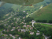
Localities
The historic core of the town lies around the church and along the High Street. With the building of the railway line and station in 1852, the town began to grow towards the new station, along what is today Sandford Avenue. Since the first half of the 20th century the two main streets of the town centreTown centre
The town centre is the term used to refer to the commercial or geographical centre or core area of a town.Town centres are traditionally associated with shopping or retail. They are also the centre of communications with major public transport hubs such as train or bus stations...
are the High Street and Sandford Avenue.
Cunnery is a hillside and collection of houses to the west of the town centre and includes the Long Mynd Hotel. World's End is where the Ludlow Road curves round the foot of the hillside to the south of the Long Mynd Hotel. To the north of the town centre is an area called Ashbrook; here the Carding Mill Valley meets the town, with the stream (known as the Ashbrook as it runs through the town) running between the town's two main recreation fields (named Russell's Meadow and Richard Robinson Field). Two other notable areas of public parkland are Rectory Field & Wood, situated to the west of the town centre off Church Street, and the town's formal park between the A49 and the railway line, which is managed by the town council and includes tennis courts and a bowling green.
On the eastern side of the A49 road are the areas of Battle Field (or Battlefield) and Hazler; on Hazler Hill is a transmitter
Transmitter
In electronics and telecommunications a transmitter or radio transmitter is an electronic device which, with the aid of an antenna, produces radio waves. The transmitter itself generates a radio frequency alternating current, which is applied to the antenna. When excited by this alternating...
for local radio (BBC
BBC
The British Broadcasting Corporation is a British public service broadcaster. Its headquarters is at Broadcasting House in the City of Westminster, London. It is the largest broadcaster in the world, with about 23,000 staff...
Radio Shropshire broadcast from here on 90FM). Battle Field is named for the legend that Caer Caradoc was the site of the last stand of Caractacus against the Roman legions during the Roman conquest of Britain, and that after the battle
Battle of Caer Caradoc
The Battle of Caer Caradoc was the final battle in Caratacus's resistance to Roman rule. Fought in 50, the Romans defeated the Britons and thus secured the southern areas of the province of Britannia....
he hid in the cave near its summit.
Governance
The town is located within the civil parish of Church Stretton, and is administered by a town councilTown council
A town council is a democratically elected form of government for small municipalities or civil parishes. A council may serve as both the representative and executive branch....
, which also manages the neighbouring villages of All Stretton
All Stretton
All Stretton is a village and civil parish in Shropshire, England.-Geography:All Stretton lies about a mile to the north of the market town of Church Stretton, on the old Shrewsbury Road - the county town is 12 miles to the north. Similarly, the small village of Little Stretton lies to the south...
, Little Stretton
Little Stretton, Shropshire
Little Stretton is a village in Shropshire, England.It lies on the B5477 to the south of the town of Church Stretton ; similarly, the small village of All Stretton lies to the north of Church Stretton on the same road...
, and the hamlets of Minton
Minton, Shropshire
Minton is a hamlet in Shropshire, England.It is located in the parish of Church Stretton, 2½ miles southwest of the market town of Church Stretton. A historic settlement, it is situated on a foothill of the Long Mynd at around 240m above sea level...
and Hamperley
Hamperley
Hamperley is a dispersed hamlet in Shropshire, England.It is mainly located in the parish of Church Stretton, 2½ miles southwest of Little Stretton and 4 miles from the market town of Church Stretton...
. At the 2001 census, the parish's population was 4,186. The parish is divided into four wards: Church Stretton North (represented by four councillors on the town council), Church Stretton South (represented by five councillors), All Stretton and Little Stretton (each represented by two councillors).
Sometimes the parish is referred to as "Church Stretton and Little Stretton"; the parish was formed from the merger of the former Little Stretton and Church Stretton parishes, together with part of All Stretton parish (the remainder still exists as a separate parish).
Church Stretton is part of the Shropshire Council
Shropshire Council
Shropshire Council is a unitary authority in Shropshire, United Kingdom.It replaced the former two-tier local government structure in the non-metropolitan county of Shropshire on 1 April 2009, which involved its immediate predecessor, Shropshire County Council, and five non-metropolitan districts -...
electoral division
Wards of the United Kingdom
A ward in the United Kingdom is an electoral district at sub-national level represented by one or more councillors. It is the primary unit of British administrative and electoral geography .-England:...
of Church Stretton and Craven Arms.
On a national level, Church Stretton is located within the Ludlow constituency
Ludlow (UK Parliament constituency)
Ludlow is a county constituency represented in the House of Commons of the Parliament of the United Kingdom. It elects one Member of Parliament by the first past the post system of election....
, and the current MP for that constituency is Philip Dunne
Philip Dunne (politician)
Philip Martin Dunne is a British Conservative Party politician and the Member of Parliament for the Ludlow constituency in Shropshire....
, a Conservative
Conservative Party (UK)
The Conservative Party, formally the Conservative and Unionist Party, is a centre-right political party in the United Kingdom that adheres to the philosophies of conservatism and British unionism. It is the largest political party in the UK, and is currently the largest single party in the House...
MP.
Geology
The local geology is complex; the area lies astride the Church Stretton Fault and atop some of the oldest rocks in England - formed over 560 mya. On 2 April 1990, another nearby fault - the PontesfordPontesford
Pontesford is a small village in Shropshire, England.It is located on the A488 outside the large village of Pontesbury.It approximates to the northern extremity of the Pontesford-Linley geological fault, which trends approximately 11 miles to Linley near Bishops Castle...
-Linley
Linley, Shropshire
Linley is a small village in Shropshire, England, on the West Onny river close to Linley Hall.It is located circa 2 miles east of the A488, and 2 miles north of the larger village of Lydham, and 3.5 miles north of Bishops Castle....
Fault - registered an earthquake
Earthquake
An earthquake is the result of a sudden release of energy in the Earth's crust that creates seismic waves. The seismicity, seismism or seismic activity of an area refers to the frequency, type and size of earthquakes experienced over a period of time...
with a magnitude of 5.1 on the Richter scale
Richter magnitude scale
The expression Richter magnitude scale refers to a number of ways to assign a single number to quantify the energy contained in an earthquake....
, known as the Bishop's Castle earthquake
1990 Bishop's Castle earthquake
The 1990 Bishop's Castle earthquake was an earthquake that hit near the town of Bishop's Castle, Shropshire, England on 2 April 1990.-Location, date and time:...
. The area also plays a part in the history of geology: the three major subdivsions of the Lower Paleozoic
Paleozoic
The Paleozoic era is the earliest of three geologic eras of the Phanerozoic eon, spanning from roughly...
are named for local celt
Celt
The Celts were a diverse group of tribal societies in Iron Age and Roman-era Europe who spoke Celtic languages.The earliest archaeological culture commonly accepted as Celtic, or rather Proto-Celtic, was the central European Hallstatt culture , named for the rich grave finds in Hallstatt, Austria....
ic tribes - Cambrian
Cambrian
The Cambrian is the first geological period of the Paleozoic Era, lasting from Mya ; it is succeeded by the Ordovician. Its subdivisions, and indeed its base, are somewhat in flux. The period was established by Adam Sedgwick, who named it after Cambria, the Latin name for Wales, where Britain's...
, Ordovician
Ordovician
The Ordovician is a geologic period and system, the second of six of the Paleozoic Era, and covers the time between 488.3±1.7 to 443.7±1.5 million years ago . It follows the Cambrian Period and is followed by the Silurian Period...
& Silurian
Silurian
The Silurian is a geologic period and system that extends from the end of the Ordovician Period, about 443.7 ± 1.5 Mya , to the beginning of the Devonian Period, about 416.0 ± 2.8 Mya . As with other geologic periods, the rock beds that define the period's start and end are well identified, but the...
. Also, Comley
Comley
Comley is a small settlement in Shropshire, England. It is near the A49 road.-External links:*...
Quarry is about 2.5 miles (4 km) from the town and the first site in the British Isles where trilobite
Trilobite
Trilobites are a well-known fossil group of extinct marine arthropods that form the class Trilobita. The first appearance of trilobites in the fossil record defines the base of the Atdabanian stage of the Early Cambrian period , and they flourished throughout the lower Paleozoic era before...
s were recorded.
Transport
The A49A49 road
The A49 is a major road in western England, which traverses the Welsh Marches region. It runs north from Ross-on-Wye in Herefordshire via Hereford, Leominster, Ludlow, Shrewsbury and Whitchurch, then continues through central Cheshire to Warrington and Wigan before terminating at its junction with...
runs through the Stretton valley, from Shrewsbury in the north towards Ludlow
Ludlow
Ludlow is a market town in Shropshire, England close to the Welsh border and in the Welsh Marches. It lies within a bend of the River Teme, on its eastern bank, forming an area of and centred on a small hill. Atop this hill is the site of Ludlow Castle and the market place...
and Hereford
Hereford
Hereford is a cathedral city, civil parish and county town of Herefordshire, England. It lies on the River Wye, approximately east of the border with Wales, southwest of Worcester, and northwest of Gloucester...
to the south. The B5477 runs through the villages of All Stretton and Little Stretton, as well as the historic core and town centre of Church Stretton. The B4371 starts at the B5477 in the town centre and heads east, having a crossroads junction with the A49, then up to Hazler and on towards Much Wenlock
Much Wenlock
Much Wenlock, earlier known as Wenlock, is a small town in central Shropshire, England. It is situated on the A458 road between Shrewsbury and Bridgnorth. Nearby, to the northeast, is the Ironbridge Gorge, and the new town of Telford...
. The B4371 in the town (on both sides of the A49) is known as Sandford Avenue and is partially lined with lime trees.
The B5477 was, until renumbered in 2004, the northern section of the B4370. The renumbering to B5477 is inexplicable in two ways - the number does not comply with the Great Britain road numbering scheme
Great Britain road numbering scheme
The Great Britain road numbering scheme is a numbering scheme used to classify and identify all roads in Great Britain. Each road is given a single letter, which represents the road's category, and a subsequent number, with a length of between 1 and 4 digits. Originally introduced to arrange...
(it is "out-of-zone") and is already in use in Wallasey
Wallasey
Wallasey is a town within the Metropolitan Borough of Wirral, in Merseyside, England, on the mouth of the River Mersey, at the northeastern corner of the Wirral Peninsula...
.
The Welsh Marches Line
Welsh Marches Line
The Welsh Marches Line , known historically as the North and West Route, is the railway line running from Newport in south-east Wales to Shrewsbury in the West Midlands region of England by way of Abergavenny, Hereford and Craven Arms, and thence to Crewe via Whitchurch...
runs through the town and there is a station
Church Stretton railway station
Church Stretton railway station is a railway station serving the town of Church Stretton in Shropshire, England. It is situated on the Welsh Marches Line, 12¾ miles south of Shrewsbury railway station, while trains on the Heart of Wales Line also serve the station...
, situated off Sandford Avenue just east of the town centre, near the junction of the A49 and B4371. The railway was originally built as the Shrewsbury and Hereford Railway
Shrewsbury and Hereford Railway
The Shrewsbury and Hereford Railway was an independently developed English railway, the first to run train services in Herefordshire.Built between 1850 and 1853, it crossed a number of services by both the Great Western Railway and London and North Western Railway companies, became a joint...
in 1852. Trains on the Heart of Wales Line
Heart of Wales Line
The Heart of Wales Line is a railway line running from Craven Arms in Shropshire to Llanelli in South Wales. It runs, as the name suggests, through some of the heartlands of Wales. It serves a number of rural centres en route, including several once fashionable spa towns, including Llandrindod Wells...
also call at the station. Today there are direct train services to Shrewsbury, Chester
Chester
Chester is a city in Cheshire, England. Lying on the River Dee, close to the border with Wales, it is home to 77,040 inhabitants, and is the largest and most populous settlement of the wider unitary authority area of Cheshire West and Chester, which had a population of 328,100 according to the...
, Holyhead
Holyhead
Holyhead is the largest town in the county of Anglesey in the North Wales. It is also a major port adjacent to the Irish Sea serving Ireland....
, Crewe
Crewe
Crewe is a railway town within the unitary authority area of Cheshire East and the ceremonial county of Cheshire, England. According to the 2001 census the urban area had a population of 67,683...
, Manchester
Manchester
Manchester is a city and metropolitan borough in Greater Manchester, England. According to the Office for National Statistics, the 2010 mid-year population estimate for Manchester was 498,800. Manchester lies within one of the UK's largest metropolitan areas, the metropolitan county of Greater...
, Ludlow
Ludlow
Ludlow is a market town in Shropshire, England close to the Welsh border and in the Welsh Marches. It lies within a bend of the River Teme, on its eastern bank, forming an area of and centred on a small hill. Atop this hill is the site of Ludlow Castle and the market place...
, Hereford
Hereford
Hereford is a cathedral city, civil parish and county town of Herefordshire, England. It lies on the River Wye, approximately east of the border with Wales, southwest of Worcester, and northwest of Gloucester...
, Newport
Newport
Newport is a city and unitary authority area in Wales. Standing on the banks of the River Usk, it is located about east of Cardiff and is the largest urban area within the historic county boundaries of Monmouthshire and the preserved county of Gwent...
, Cardiff
Cardiff
Cardiff is the capital, largest city and most populous county of Wales and the 10th largest city in the United Kingdom. The city is Wales' chief commercial centre, the base for most national cultural and sporting institutions, the Welsh national media, and the seat of the National Assembly for...
and Swansea
Swansea
Swansea is a coastal city and county in Wales. Swansea is in the historic county boundaries of Glamorgan. Situated on the sandy South West Wales coast, the county area includes the Gower Peninsula and the Lliw uplands...
.
The town is served by the 435 bus route (the Shrewsbury-Ludlow service), run by Minsterley Motors
Minsterley Motors
Minsterley Motors is a bus operator and limited company based in Minsterley, Shropshire, England.The company's main operations concentrate on stage service and schools contract work for Shropshire County Council...
, which runs Monday-Saturday. This connects the town with All Stretton, Dorrington
Dorrington, Shropshire
Dorrington is a large village in Shropshire, England, located 6 miles south of Shrewsbury. The population of the village was estimated as being 619 in 2008....
and Condover
Condover
Condover is a village and civil parish in Shropshire, England. It lies 4.7 miles south of the county town of Shrewsbury, and just east of the A49. The Cound Brook flows through the village on its way from the Stretton Hills to a confluence with the River Severn...
towards Shrewsbury, and Little Stretton, Craven Arms and Bromfield
Bromfield, Shropshire
Bromfield is a village and civil parish in Shropshire, England.According to the 2001 census it had a population of 306.-Location:Bromfield is located near the market town of Ludlow, two miles north of the town on the A49 road....
towards Ludlow. In addition there is a Shropshire Hills Shuttles service (route 780) that operates during the spring/summer, which runs over the Long Mynd to Ratlinghope
Ratlinghope
Ratlinghope is a village and civil parish in Shropshire, England. It is situated four miles west from Church Stretton and twelve miles south from Shrewsbury.Historically it is located in the hundred of Purslow...
& Bridges, Stiperstones
Stiperstones
The Stiperstones is a very distinctive hill in the county of Shropshire, England. It is a quartzite ridge formed some 480 Million years ago. During the last Ice Age the summit stood out above the glaciers and was subject to constant freezing and thawing which shattered the quartzite into a mass of...
, Habberley
Habberley, Shropshire
Habberley is a small village in the English county of Shropshire.Habberley lies near the Stiperstones southwest of the town of Shrewsbury.Formerly a small civil parish in its own right Habberley was merged in to the Pontesbury civil parish in 1967. In 1824 its population was recorded as 151 - by...
, Pulverbatch, Minsterley
Minsterley
Minsterley is a village and civil parish in Shropshire, England. It is home to a large dairy operated by Uniq foods.The dairy currently employs nearly 500 people...
and Pontesbury
Pontesbury
Pontesbury is a large village and civil parish in Shropshire and is approximately eight miles southwest of the county town of Shrewsbury. The village of Minsterley is just over a mile further southwest. The A488 road runs through the village, on its way from Shrewsbury to Bishop's Castle...
. This operates at the weekends and on Bank Holiday
Bank Holiday
A bank holiday is a public holiday in the United Kingdom or a colloquialism for public holiday in Ireland. There is no automatic right to time off on these days, although the majority of the population is granted time off work or extra pay for working on these days, depending on their contract...
Mondays.
Regional Cycle Route 32/33 runs through the town, on its way from Shrewsbury to Craven Arms. The route avoids cycling along the busy A49 main road, with the exception of a stretch north of Craven Arms.
Education
Church Stretton has two schools, both run by Shropshire CouncilShropshire Council
Shropshire Council is a unitary authority in Shropshire, United Kingdom.It replaced the former two-tier local government structure in the non-metropolitan county of Shropshire on 1 April 2009, which involved its immediate predecessor, Shropshire County Council, and five non-metropolitan districts -...
: a secondary school with 750 pupils and a primary school (named "St Lawrence") with 210 pupils. The two schools neighbour one other and are situated just off Shrewsbury Road, on the northern edge of Church Stretton. The Council also operates a public library, on Church Street, situated in former, Victorian school buildings, which is also the town's visitor centre.
Economy
The mineral waterMineral water
Mineral water is water containing minerals or other dissolved substances that alter its taste or give it therapeutic value, generally obtained from a naturally occurring mineral spring or source. Dissolved substances in the water may include various salts and sulfur compounds...
bottling plant on Shrewsbury Road is a notable local employer. Another notable employer is the technology laboratories off Essex Road, currently owned by Agilent Technologies
Agilent Technologies
Agilent Technologies , or Agilent, is a company that designs and manufactures electronic and bio-analytical measurement instruments and equipment for measurement and evaluation...
(until 2009 by Varian
Varian, Inc.
Varian, Inc. was one of the largest manufacturers of scientific instruments for the scientific industry; they had offerings over the whole range of chemical analysis equipment, with a particular focus on Information Rich Detection and Vacuum technology...
). There is a designated industrial estate/business park area between the A49 and the railway line, with a number of small businesses operating.
The town benefits from tourism, which is a growth industry in the area, as well as attracting local trade. A recent survey showed that the town has some fifty retail outlets, 44 of which are independently-owned, with a high diversity of shop types. The offer in the town centre includes two butchers, several outdoor activities shops, bakers and delicatessens, several clothes and shoe shops, three banks, and a Co-op
The Co-operative Group
The Co-operative Group Ltd. is a United Kingdom consumer cooperative with a diverse range of business interests. It is co-operatively run and owned by its members. It is the largest organisation of this type in the world, with over 5.5 million members, who all have a say in how the business is...
supermarket. There is a large antiques
Antiques
An antique is an old collectible item. It is collected or desirable because of its age , beauty, rarity, condition, utility, personal emotional connection, and/or other unique features...
market, situated in a former malthouse
Malthouse
A malt house, or maltings, is a building where cereal grain is converted into malt by soaking it in water, allowing it to sprout and then drying it to stop further growth. The malt is used in brewing beer, whisky and in certain foods. The traditional malt house was largely phased out during the...
on the corner of Sandford Avenue and Easthope Road. There are four pubs
Public house
A public house, informally known as a pub, is a drinking establishment fundamental to the culture of Britain, Ireland, Australia and New Zealand. There are approximately 53,500 public houses in the United Kingdom. This number has been declining every year, so that nearly half of the smaller...
, as well as a number of cafes and small restaurants. In June 2011 the town was officially declared to be a "Fairtrade Town
Fairtrade Town
Fairtrade Town is a status awarded by a recognized Fairtrade certification body describing an area which is committed to the promotion of Fairtrade certified goods...
" with 34 businesses selling fair trade products. A small art gallery exists in the former hotel on the corner of Shrewsbury Road and Sandford Avenue. The town also has a number of professional services, such as solicitors, accountants and estate agents, confirming its status as a local centre of business.
As of the 2001 census, in the north ward of Church Stretton, 50.6% of residents are in employment, and 32.2% are retired
Retirement
Retirement is the point where a person stops employment completely. A person may also semi-retire by reducing work hours.Many people choose to retire when they are eligible for private or public pension benefits, although some are forced to retire when physical conditions don't allow the person to...
; unemployment
Unemployment
Unemployment , as defined by the International Labour Organization, occurs when people are without jobs and they have actively sought work within the past four weeks...
is at 2%. In Church Stretton's south ward, the rate of employment is higher, at 57.5%, with 24.9% of residents retired; the rate of unemployment is 1.9%.
Culture and sport
Henry Kingsley
Henry Kingsley was an English novelist, brother of the better-known Charles Kingsley.Kingsley was born at Barnack rectory, Northamptonshire, son of the Rev. Charles Kingsley the elder, Mary, née Lucas. Charles Kingsley came of a long line of clergymen and soldiers, and in addition to the two...
(1830–1876) wrote "Stretton" based around this area, and Oliver Sandys' book, "Quaint Place" is set in Church Stretton. Mary Webb
Mary Webb
Mary Webb , was an English romantic novelist and poet of the early 20th century, whose work is set chiefly in the Shropshire countryside and among Shropshire characters and people which she knew. Her novels have been successfully dramatized, most notably the film Gone to Earth in 1950 by Michael...
's works also made reference to the town, under the name "Shepwardine". The Lone Pine Club series of children's books by Malcolm Saville
Malcolm Saville
Leonard Malcolm Saville was an English author born in Hastings, Sussex. He is best known for the Lone Pine series of children's books, many of which are set in Shropshire. His work places emphasis on place, with the books including many vivid descriptions of English countryside, villages and...
is also partly set in the area.
Church Stretton is a major centre for the sport of archery
Archery
Archery is the art, practice, or skill of propelling arrows with the use of a bow, from Latin arcus. Archery has historically been used for hunting and combat; in modern times, however, its main use is that of a recreational activity...
, and there is also a gliding air field and station atop the Long Mynd, owned by the Midland Gliding Club. As well as gliding
Gliding
Gliding is a recreational activity and competitive air sport in which pilots fly unpowered aircraft known as gliders or sailplanes using naturally occurring currents of rising air in the atmosphere to remain airborne. The word soaring is also used for the sport.Gliding as a sport began in the 1920s...
, the activities of paragliding
Paragliding
Paragliding is the recreational and competitive adventure sport of flying paragliders: lightweight, free-flying, foot-launched glider aircraft with no rigid primary structure...
, hang gliding
Hang gliding
Hang gliding is an air sport in which a pilot flies a light and unmotorized foot-launchable aircraft called a hang glider ....
and similar aerial pursuits take place from the Long Mynd. In the town itself, sports facilities are provided adjacent to the schools, just off Shrewsbury Road, which include a swimming pool and fitness centre, and the town council provide facilities (such as tennis courts, a bowling green and a croquet pitch) at the town park.
Summer festival
In recent times, every year on a June Saturday the town holds a summer festival ("summerfest"), organised by the town's chamber of trade. The town centre's streets and car parks are closed to traffic, as stalls, entertainment and activities take place throughout the town, including a classic carClassic car
A classic car is an older car; the exact meaning is variable. The Classic Car Club of America maintains that a car must be between 20 and 40 years old to be a classic, while cars over 45 years fall into the Antique Class.- Classic Car Club of America :...
and steam
Traction engine
A traction engine is a self-propelled steam engine used to move heavy loads on roads, plough ground or to provide power at a chosen location. The name derives from the Latin tractus, meaning 'drawn', since the prime function of any traction engine is to draw a load behind it...
rally. In the evening there is a concert in Rectory Field.
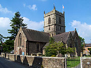
Churches
The town has four churches: the historic Anglican parish church dedicated to St Laurence, situated on the corner of Churchway and Church Street; the United Reformed ChurchUnited Reformed Church
The United Reformed Church is a Christian church in the United Kingdom. It has approximately 68,000 members in 1,500 congregations with some 700 ministers.-Origins and history:...
on Ludlow Road; a Roman Catholic church dedicated to St Milburga (a local saint), situated on the corner of Sandford Avenue and Watling Street; and a Methodist church situated on the corner of Crossways and Watling Street.
Golf course
Golf course
A golf course comprises a series of holes, each consisting of a teeing ground, fairway, rough and other hazards, and a green with a flagstick and cup, all designed for the game of golf. A standard round of golf consists of playing 18 holes, thus most golf courses have this number of holes...
about a km from the town centre, the Church Stretton Golf Club. The course is 5,030 yards long and has a par of 66. It is one of the highest golf courses in the country, being located on the side of the Long Mynd
Long Mynd
The Long Mynd in Shropshire, England, is a part of the Shropshire Hills Area of Outstanding Natural Beauty. It is south of the county town Shrewsbury, and has an area of over 22 square kilometres , most of which takes the form of a heathland plateau. Most of the land on the Long Mynd is owned by...
hill range (the course is situated on the slopes of Stanyeld Hill and Bodbury Hill). The clubhouse is at approximately 230m (755 ft) above sea level and the hilly links
Links (golf)
A links is the oldest style of golf course, first developed in Scotland. The word "links" comes from the Scots language and refers to an area of coastal sand dunes and sometimes to open parkland. It also retains this more general meaning in the Scottish English dialect...
course rises up to around 375m (1,230 ft). Apart from the clubhouse, putting green and first hole, the course is situated on common land
Common land
Common land is land owned collectively or by one person, but over which other people have certain traditional rights, such as to allow their livestock to graze upon it, to collect firewood, or to cut turf for fuel...
owned by the National Trust
National Trust for Places of Historic Interest or Natural Beauty
The National Trust for Places of Historic Interest or Natural Beauty, usually known as the National Trust, is a conservation organisation in England, Wales and Northern Ireland...
(who own most of the Long Mynd
Long Mynd
The Long Mynd in Shropshire, England, is a part of the Shropshire Hills Area of Outstanding Natural Beauty. It is south of the county town Shrewsbury, and has an area of over 22 square kilometres , most of which takes the form of a heathland plateau. Most of the land on the Long Mynd is owned by...
upland area).
The town's golf course is the oldest 18-hole course in Shropshire, with the club starting in 1898 and the final holes being completed around 1904. The course was primarily designed by John (Jack) Morris and James Hepburn. James Braid
James Braid (golfer)
James Braid was a Scottish professional golfer and a member of the Great Triumvirate of the sport alongside Harry Vardon and John Henry Taylor. He won The Open Championship five times...
and Harry Vardon
Harry Vardon
Harry Vardon was a Jersey professional golfer and member of the fabled Great Triumvirate of the sport in his day, along with John Henry Taylor and James Braid. He won The Open Championship a record six times and also won the U.S. Open.-Biography:Vardon was born in Grouville, Jersey, Channel Islands...
later made changes to the course.
Open Champions
The Open Championship
The Open Championship, or simply The Open , is the oldest of the four major championships in professional golf. It is the only "major" held outside the USA and is administered by The R&A, which is the governing body of golf outside the USA and Mexico...
James Braid, Harry Vardon and J. H. Taylor
John Henry Taylor
John Henry "J.H." Taylor was an English professional golfer and one of the pioneers of the modern game of golf. He was also a significant golf course architect....
(together referred to as the Great Triumvirate
Great Triumvirate (golf)
The Great Triumvirate, in a golfing context, refers to the three leading British golfers of the late 19th and early 20th centuries: Harry Vardon, John Henry Taylor, and James Braid. The trio combined to win The Open Championship 16 times in the 21 tournaments held between 1894 and 1914; Vardon...
) all played at the course many times, albeit at different times, during the pre-World War I years of the club's existence.
Football
Church Stretton Town F.C. are a football team who currently play in the Shropshire County Premier Football LeagueShropshire County Premier Football League
The Shropshire County Premier Football League is an English association football league based in the county of Shropshire...
's Premier Division. Home games are played at Russell's Meadow, located near the centre of the town off Lutwyche Road . In the 2009-10 season, Church Stretton were winners of the Sentinel News First Division Cup, convincingly beating Brown Clee 5-1 in the final. In the 2010-11 season, Church Stretton finished 2nd in Division One, gaining promotion to the Premier Division for 2011-12. Having completed the season, the side then won the SFA
Shropshire Football Association
The Shropshire Football Association is the governing body of football in the county of Shropshire. Cup competitions it organises include the Shropshire Senior Cup, the Challenge Cup and the Junior Cup.-External links:*...
Williams & Picken Junior Cup, beating Premier Division side Ellesmere Rangers Reserves at Shrewsbury Town's ground, the New Meadow
New Meadow
The New Meadow, also known as the Greenhous Meadow for sponsorship purposes, is the home ground of Shrewsbury Town Football Club and is a UEFA Category Four stadium. The stadium is situated on the southern outskirts of Shrewsbury, England, between the districts of Meole Brace and Sutton Farm...
.
There has been a football field at Russell's Meadow since the 1930s, though the pavilion moved (c. 1950s) from the other side of the Ashbrook to its present location near Lutwyche Road. There is a community project on-going to raise funds and then build a new pavilion at Russell's Meadow. A number of junior teams play at Russell's Meadow whilst during the summer the Meadow and its pavilion are used to play cricket
Cricket
Cricket is a bat-and-ball game played between two teams of 11 players on an oval-shaped field, at the centre of which is a rectangular 22-yard long pitch. One team bats, trying to score as many runs as possible while the other team bowls and fields, trying to dismiss the batsmen and thus limit the...
.
Notable people
Residents of the town did include Pete PostlethwaitePete Postlethwaite
Peter William "Pete" Postlethwaite, OBE, was an English stage, film and television actor.After minor television appearances including in The Professionals, Postlethwaite's first success came with the film Distant Voices, Still Lives in 1988. He played a mysterious lawyer, Mr...
, who used to live in Minton, near Little Stretton, which was the home of Oliver Sandys. Also, the Olympic bronze-medal archer, Alison Williamson
Alison Williamson
Alison Jane Williamson is an athlete from Great Britain. She competes in archery.Williamson, who is a member of the Long Mynd Archers, has represented Great Britain at five Olympic Games, from 1992-2008....
lives in All Stretton. In the 1930s, E. M. Almedingen
E. M. Almedingen
E. M. Almedingen was a British novelist, biographer and children's author of Russian origin....
, the biographer and children's writer, lived in the town, and, following retirement, the writer Kenneth Bird moved to Church Stretton.
The 'White House' nursing home
Nursing home
A nursing home, convalescent home, skilled nursing unit , care home, rest home, or old people's home provides a type of care of residents: it is a place of residence for people who require constant nursing care and have significant deficiencies with activities of daily living...
on Sandford Avenue was demolished in 2006 to make way for a housing development, and it was previously the family home of Charles Silvester Horne
Charles Silvester Horne
Charles Silvester Horne was a famous late 19th century and early 20th century Congregationalist who additionally served as Liberal M.P. for Ipswich....
a congregationalist minister, Liberal
Liberal Party (UK)
The Liberal Party was one of the two major political parties of the United Kingdom during the 19th and early 20th centuries. It was a third party of negligible importance throughout the latter half of the 20th Century, before merging with the Social Democratic Party in 1988 to form the present day...
MP for Ipswich
Ipswich
Ipswich is a large town and a non-metropolitan district. It is the county town of Suffolk, England. Ipswich is located on the estuary of the River Orwell...
, and father of the BBC broadcaster Kenneth Horne
Kenneth Horne
Kenneth Horne was an English comedian and businessman. The son of a clergyman and politician, he combined a successful business career with regular broadcasting for the BBC. His first hit series Much-Binding-in-the-Marsh written with his co-star Richard Murdoch arose out of his wartime service as...
. The town's Silvester Horne Institute, on Ludlow Road, commemorates his name.
Hesba Stretton
Hesba Stretton
Hesba Stretton was the pen name of Sarah Smith , an English writer of children's books. She concocted the name from the initials of her five siblings and the name of a neighbouring village.-Early life:...
came to Church Stretton often before moving away from Shropshire, becoming an established author. There is a plaque to her memory in St. Laurence's Church together with a window depicting the figure of "Jessica" from her immensely popular story Jessica's First Prayer.
Stephen Laurie
Stephen P. Laurie
Stephen P. Laurie is a British amateur astronomer. He is a prolific discoverer of asteroids and comets, although his profession is that of an actuary...
, a notable amateur astronomer
Astronomer
An astronomer is a scientist who studies celestial bodies such as planets, stars and galaxies.Historically, astronomy was more concerned with the classification and description of phenomena in the sky, while astrophysics attempted to explain these phenomena and the differences between them using...
, lives in the area and has discovered a number of asteroid
Asteroid
Asteroids are a class of small Solar System bodies in orbit around the Sun. They have also been called planetoids, especially the larger ones...
s from observatories at Church Stretton and nearby Ragdon (the area not suffering from much light pollution
Light pollution
Light pollution, also known as photopollution or luminous pollution, is excessive or obtrusive artificial light.The International Dark-Sky Association defines light pollution as:...
). One of the asteroids discovered has been named after the town — 11626 Church Stretton
11626 Church Stretton
11626 Church Stretton is a main belt asteroid with an orbital period of 1247.4976842 days . The asteroid was discovered on November 8, 1996. It is named for the town of Church Stretton in England, where it was discovered by Stephen P. Laurie .Its provisional designation was 1996 VW2.-See also:*7603...
.
Further reading
- My Story of St Dunstan'sSt Dunstan'sSt Dunstan's is a large national charity in the United Kingdom, providing support, rehabilitation and respite care to blind ex-service personnel of the British Armed Forces....
(1961) by Lord Fraser of LonsdaleIan Fraser, Baron Fraser of LonsdaleWilliam Jocelyn Ian Fraser, Baron Fraser of Lonsdale CH CBE, , known as Ian Fraser, was a British Conservative Party politician, a Governor of the BBC, a successful businessman and the first person to be awarded a life peerage under the Life Peerages Act 1958.Fraser was blinded in World War I and...