
River Teme
Encyclopedia
The River Teme rises in Mid Wales
, south of Newtown in Powys
, and flows through Knighton where it crosses the border into England
down to Ludlow
in Shropshire
, then to the north of Tenbury Wells
on the Shropshire/Worcestershire
border there, on its way to join the River Severn
south of Worcester. The whole of the River Teme was designated as an SSSI, by English Nature
, in 1996.
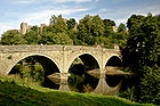
The river is crossed by a number of historic bridges including one at Tenbury Wells that was rebuilt by Thomas Telford
following flood damage in 1795. It is also crossed, several times, by the Elan aqueduct
.
, River Thames
, River Thame
, River Tame and River Tamar
. Scholars now believe these names and the older names Temese and Tamesis derive from Brythonic
Tamesa, possibly meaning 'the dark one'.
near Dolfor, south of Newtown. Two other rivers - the River Ithon
and the River Mule - rise within 500 metres. It flows across the border into England
through Knighton. From there to its confluence with the River Severn, at Worcester (about 60 miles/100 km downstream) it flows through the counties of Herefordshire
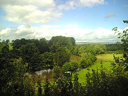
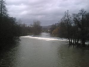
, Shropshire and Worcestershire. The upper reaches of the river are usually steep with fast flowing but relatively shallow waters. There are some water mills, and a number of weir
s, including several at the historic town of Ludlow. Below Tenbury Wells the river is more tranquil but still shallow, with strong cross currents. Water levels in the Teme are highly variable, something which has been made worse in recent years through increases in water extraction for agriculture use.
 During its journey the river flows over Upper Ludlow shales
and Devonian
sandstones.
The River Clun
flows into the Teme at Leintwardine
in north Herefordshire. The River Corve
flows into the Teme just outside Ludlow and the Ledwyche Brook flows into the Teme at Burford
on the Herefordshire/Shropshire border. The Kyre Brook flows into the Teme at Tenbury Wells, and the River Rea
flows into the Teme at Newnham Bridge
, Worcestershire, a few miles south of Cleobury Mortimer
, a small Shropshire town.
The Teme falls nearly 500 metres during its length from a height of 506 metres above sea level
at its source to just 14 metres above sea-level at its confluence with the River Severn.
The Teme has in recent times often bursts its banks. June and July 2007 saw serious floods in a number of areas, including Leintwardine, Tenbury Wells and Ludlow although the watercourse that flooded the latter location was a tributary, the River Corve.
It is the 14th longest river in the United Kingdom; top-10 for England and Wales.
.jpg)
is recovering, but obstructions keep salmon
numbers at a low level.
is popular on many stretches of the Teme, with its barbel
fishing being particularly noted.
 Leisure boats have long been used on the river and rowing boats can still be hired at The Linney Park, Ludlow
. An annual coracle
regatta is held on the Teme. In June 2005 it was held at Leintwardine
. In June 2006, the 12th regatta was held at Mortimer's Cross.
A Countryside Agency
report in September 2003 entitled Improving access for canoeing on inland waterways: A study of the feasibility of access agreements stated:
Information on canoeing on the Teme in the Ludlow area is available here and on the Tenbury Wells to Broadwas area here.
bridge and Mill
to its confluence with the river Severn that the Teme is (or was) navigable
. There was a coal
wharf
near Powick Bridge, belonging with the mill, whose owner had the right to use a towing path to the river Severn. In the 18th century, pig iron
was brought up the river to Powick forge
(as the mill then was). In 1810 it was reported that "The Teme is also navigable for barges from its junction with the Severn near Powick upwards to a small distance above Powick Bridge. The river having considerable declivity its navigation is soon interrupted by shoals and shallows"
times and 'continued in Norman
times, when it is known the stone for the mill at Ashford Carbonel
was brought from Caen
in the 14th century, using water transport all the way'. However no unequivocal documentary or archaeological evidence has been adduced in support of this.
William Sandys
who between 1636 and 1639 made the Avon
) navigable from Tewkesbury
to Stratford-upon-Avon
was at the same time also authorised to improve the Teme between Worcester and Ludlow. There is however no evidence that he did so, perhaps due to his having used up all his resources on the Avon. Having failed to recover the Avon after the Restoration, Sir William Sandys and his son undertook work on the Wye
and Lugg
.
Ferries formerly existed at Rochford, at Cotheridge and at Clifton on Teme. Some very local navigation is indicated by a newspaper advertisement in 1750 that the miller at Stanford-on-Teme
had a boat for sale, capable of carrying 10 tons. However, with no locks available, this vessel would have been unable to pass mill weirs.
Pictures, allegedly of Ludlow
or its castle with a river and boats (thought to date from c.1830), such as A painting allegedly of Dinham Bridge, Ludlow. are probably at least partly derived from the artist's imagination.
This subject was debated at length in 2006 in the Journal of Railway and Canal Historical Society.
Mid Wales
Mid Wales is the name given to the central region of Wales. The Mid Wales Regional Committee of the National Assembly for Wales covered the counties of Ceredigion and Powys and the area of Gwynedd that had previously been the district of Meirionydd. A similar definition is used by the BBC...
, south of Newtown in Powys
Powys
Powys is a local-government county and preserved county in Wales.-Geography:Powys covers the historic counties of Montgomeryshire and Radnorshire, most of Brecknockshire , and a small part of Denbighshire — an area of 5,179 km², making it the largest county in Wales by land area.It is...
, and flows through Knighton where it crosses the border into England
England
England is a country that is part of the United Kingdom. It shares land borders with Scotland to the north and Wales to the west; the Irish Sea is to the north west, the Celtic Sea to the south west, with the North Sea to the east and the English Channel to the south separating it from continental...
down to Ludlow
Ludlow
Ludlow is a market town in Shropshire, England close to the Welsh border and in the Welsh Marches. It lies within a bend of the River Teme, on its eastern bank, forming an area of and centred on a small hill. Atop this hill is the site of Ludlow Castle and the market place...
in Shropshire
Shropshire
Shropshire is a county in the West Midlands region of England. For Eurostat purposes, the county is a NUTS 3 region and is one of four counties or unitary districts that comprise the "Shropshire and Staffordshire" NUTS 2 region. It borders Wales to the west...
, then to the north of Tenbury Wells
Tenbury Wells
Tenbury Wells is a market town and civil parish in the north-western extremity of the Malvern Hills District administrative area of Worcestershire, England. The 2001 census reported a population of 3,316.-Geography:...
on the Shropshire/Worcestershire
Worcestershire
Worcestershire is a non-metropolitan county, established in antiquity, located in the West Midlands region of England. For Eurostat purposes it is a NUTS 3 region and is one of three counties that comprise the "Herefordshire, Worcestershire and Warwickshire" NUTS 2 region...
border there, on its way to join the River Severn
River Severn
The River Severn is the longest river in Great Britain, at about , but the second longest on the British Isles, behind the River Shannon. It rises at an altitude of on Plynlimon, Ceredigion near Llanidloes, Powys, in the Cambrian Mountains of mid Wales...
south of Worcester. The whole of the River Teme was designated as an SSSI, by English Nature
English Nature
English Nature was the United Kingdom government agency that promoted the conservation of wildlife, geology and wild places throughout England between 1990 and 2006...
, in 1996.
The river is crossed by a number of historic bridges including one at Tenbury Wells that was rebuilt by Thomas Telford
Thomas Telford
Thomas Telford FRS, FRSE was a Scottish civil engineer, architect and stonemason, and a noted road, bridge and canal builder.-Early career:...
following flood damage in 1795. It is also crossed, several times, by the Elan aqueduct
Elan aqueduct
The Elan aqueduct, crosses Wales and the Midlands of England, running eastwards from the Elan Valley Reservoirs in Powys to Birmingham's Frankley Reservoir, carrying drinking water for Birmingham....
.
Etymology
The name Teme is similar to many other river names in England, testament to the name's ancient origin. Similar names include River TeamRiver Team
The River Team is a tributary of the River Tyne in Gateshead, England.Its source is near Annfield Plain, where it is known as Kyo Burn. Then changing its name again to Causey Burn as it flows underneath the famous Causey Arch. It then flows past Beamish Museum in County Durham then crosses the...
, River Thames
River Thames
The River Thames flows through southern England. It is the longest river entirely in England and the second longest in the United Kingdom. While it is best known because its lower reaches flow through central London, the river flows alongside several other towns and cities, including Oxford,...
, River Thame
River Thame
The River Thame is a river in Southern England. It is a tributary of the larger and better-known River Thames.The general course of the River Thame is north-east to south-west and the distance from its source to the River Thames is about 40 miles...
, River Tame and River Tamar
River Tamar
The Tamar is a river in South West England, that forms most of the border between Devon and Cornwall . It is one of several British rivers whose ancient name is assumed to be derived from a prehistoric river word apparently meaning "dark flowing" and which it shares with the River Thames.The...
. Scholars now believe these names and the older names Temese and Tamesis derive from Brythonic
Brythonic languages
The Brythonic or Brittonic languages form one of the two branches of the Insular Celtic language family, the other being Goidelic. The name Brythonic was derived by Welsh Celticist John Rhys from the Welsh word Brython, meaning an indigenous Briton as opposed to an Anglo-Saxon or Gael...
Tamesa, possibly meaning 'the dark one'.
Geography
The river source is in Mid Wales on Cilfaesty Hill in the Kerry HillsKerry, Powys
Kerry is a small village in Powys, Mid Wales. The area around the village was the Welsh Commote and Lordship of Ceri, part of the region of Rhwng Gwy a Hafren, and it was originally ruled by the Princes of Maelienydd and their descendants....
near Dolfor, south of Newtown. Two other rivers - the River Ithon
River Ithon
The River Ithon is a major left-bank tributary of the River Wye in Powys, mid Wales. It rises in the broad saddle between the western end of Kerry Hill and the hill of Glog to its west and flows initially southwards to Llanbadarn Fynydd...
and the River Mule - rise within 500 metres. It flows across the border into England
England
England is a country that is part of the United Kingdom. It shares land borders with Scotland to the north and Wales to the west; the Irish Sea is to the north west, the Celtic Sea to the south west, with the North Sea to the east and the English Channel to the south separating it from continental...
through Knighton. From there to its confluence with the River Severn, at Worcester (about 60 miles/100 km downstream) it flows through the counties of Herefordshire
Herefordshire
Herefordshire is a historic and ceremonial county in the West Midlands region of England. For Eurostat purposes it is a NUTS 3 region and is one of three counties that comprise the "Herefordshire, Worcestershire and Gloucestershire" NUTS 2 region. It also forms a unitary district known as the...
, Shropshire and Worcestershire. The upper reaches of the river are usually steep with fast flowing but relatively shallow waters. There are some water mills, and a number of weir
Weir
A weir is a small overflow dam used to alter the flow characteristics of a river or stream. In most cases weirs take the form of a barrier across the river that causes water to pool behind the structure , but allows water to flow over the top...
s, including several at the historic town of Ludlow. Below Tenbury Wells the river is more tranquil but still shallow, with strong cross currents. Water levels in the Teme are highly variable, something which has been made worse in recent years through increases in water extraction for agriculture use.
Shalës
Shalës is a municipality in the Elbasan District, Elbasan County, central Albania. The municipality consists of the villages Shalës, Licaj, Kurtalli, Xibrake, Xherie and Kodras....
and Devonian
Devonian
The Devonian is a geologic period and system of the Paleozoic Era spanning from the end of the Silurian Period, about 416.0 ± 2.8 Mya , to the beginning of the Carboniferous Period, about 359.2 ± 2.5 Mya...
sandstones.
The River Clun
River Clun, Shropshire
The River Clun is a river in Shropshire, England which runs through the small town of Clun, as well as Newcastle-on-Clun and other villages. It meets the River Teme at Leintwardine, Herefordshire....
flows into the Teme at Leintwardine
Leintwardine
Leintwardine is a large village and civil parish in north Herefordshire, England, close to the border with Shropshire.- Roman Leintwardine :...
in north Herefordshire. The River Corve
River Corve
The River Corve is a minor river in Shropshire, England. It is a tributary of the River Teme which it joins in the town of Ludlow, and which joins the River Severn at Powick near Worcester...
flows into the Teme just outside Ludlow and the Ledwyche Brook flows into the Teme at Burford
Burford, Shropshire
Burford is a village and civil parish in Shropshire, England.- Location :The parish is situated to the north of the River Teme, on the other side of the Teme is the Worcestershire town of Tenbury Wells. To the west, the A456 road bridges the Ledwyche Brook, leading to the Herefordshire village of...
on the Herefordshire/Shropshire border. The Kyre Brook flows into the Teme at Tenbury Wells, and the River Rea
River Rea, Shropshire
The River Rea is a small river that flows through south east Shropshire, England and passes just to the east of the small market town of Cleobury Mortimer, before entering the Teme at Newnham Bridge in Worcestershire. Its waters eventually reach the Bristol Channel, via the Severn. The upper...
flows into the Teme at Newnham Bridge
Newnham Bridge
Newnham Bridge is a village in the parish of Knighton on Teme, near Tenbury Wells, Worcestershire, England, United Kingdom.The village derives part of its name from the bridge over the River Rea.-Location:...
, Worcestershire, a few miles south of Cleobury Mortimer
Cleobury Mortimer
Cleobury Mortimer is a small rural market town in Shropshire, England. The town's parish has a population of 1,962 according to the 2001 census. Although sometimes regarded as a village, it is in fact the second smallest town in Shropshire , having been granted a town charter in 1253.Several...
, a small Shropshire town.
The Teme falls nearly 500 metres during its length from a height of 506 metres above sea level
Sea level
Mean sea level is a measure of the average height of the ocean's surface ; used as a standard in reckoning land elevation...
at its source to just 14 metres above sea-level at its confluence with the River Severn.
The Teme has in recent times often bursts its banks. June and July 2007 saw serious floods in a number of areas, including Leintwardine, Tenbury Wells and Ludlow although the watercourse that flooded the latter location was a tributary, the River Corve.
It is the 14th longest river in the United Kingdom; top-10 for England and Wales.
Nature
The Teme is a clean river and after many years of decline the population of ottersEuropean Otter
The European Otter , also known as the Eurasian otter, Eurasian river otter, common otter and Old World otter, is a European and Asian member of the Lutrinae or otter subfamily, and is typical of freshwater otters....
is recovering, but obstructions keep salmon
Salmon
Salmon is the common name for several species of fish in the family Salmonidae. Several other fish in the same family are called trout; the difference is often said to be that salmon migrate and trout are resident, but this distinction does not strictly hold true...
numbers at a low level.
Fishing
FishingFishing
Fishing is the activity of trying to catch wild fish. Fish are normally caught in the wild. Techniques for catching fish include hand gathering, spearing, netting, angling and trapping....
is popular on many stretches of the Teme, with its barbel
Barbus barbus
Barbus barbus is a species of freshwater fish in the Cyprinidae family of minnows and carps. It shares the common name "barbel" with its many relatives in the genus Barbus and is properly known as the Common Barbel.B...
fishing being particularly noted.
Leisure boating
Ludlow
Ludlow is a market town in Shropshire, England close to the Welsh border and in the Welsh Marches. It lies within a bend of the River Teme, on its eastern bank, forming an area of and centred on a small hill. Atop this hill is the site of Ludlow Castle and the market place...
. An annual coracle
Coracle
The coracle is a small, lightweight boat of the sort traditionally used in Wales but also in parts of Western and South Western England, Ireland , and Scotland ; the word is also used of similar boats found in India, Vietnam, Iraq and Tibet...
regatta is held on the Teme. In June 2005 it was held at Leintwardine
Leintwardine
Leintwardine is a large village and civil parish in north Herefordshire, England, close to the border with Shropshire.- Roman Leintwardine :...
. In June 2006, the 12th regatta was held at Mortimer's Cross.
A Countryside Agency
Countryside Agency
The Countryside Agency in England was a statutory body set up in 1999 with the task of improving the quality of the rural environment and the lives of those living in it. The Agency was formed by merging the Countryside Commission and the Rural Development Commission...
report in September 2003 entitled Improving access for canoeing on inland waterways: A study of the feasibility of access agreements stated:
Information on canoeing on the Teme in the Ludlow area is available here and on the Tenbury Wells to Broadwas area here.
Leisure boating in the past
Historical evidence of leisure boating includes:- Old maps show a few boat houses along the river in Worcestershire.
- Billings Directory 1855 mentions Boat House, evidently a farmhouse, at Eastham (five miles downstream of Tenbury Wells). Boat House Farm still exists at Eastham
- The boathouse at Newnham Bridge (three miles downstream of Tenbury Wells) was large enough, and substantial enough, to be converted into a house.
- At Tenbury Wells in 1886, people were rescued during floods using a boat that had broken loose from its mooring so there must have been at least one boat on the river at that time.
- Down Along Temeside includes an account of travelling by boat from Ludford Mill to Orleton (a couple of miles upstream of Stanford Bridge) in the early 20th century.
- Tenbury Wells and the Teme Valley includes a photograph taken at Little Hereford described as 'Boating on the Teme in 1905'. The author mentions two gentlemen from Oxford who in 1894 travelled up the Teme from Worcester to Ludlow in 17.5 hours, and returned (downstream) in 9 hours.
Navigation to Powick Mill
There is no doubt that the final 1.5 miles (2.4 km) from PowickPowick
Powick is a Worcestershire village two miles south of the city of Worcester and four miles north of Great Malvern, close to the River Teme. It is a civil parish of the Malvern Hills District, and it includes the village of Callow End and the hamlets of Bastonford, Clevelode, Colletts Green, and...
bridge and Mill
Watermill
A watermill is a structure that uses a water wheel or turbine to drive a mechanical process such as flour, lumber or textile production, or metal shaping .- History :...
to its confluence with the river Severn that the Teme is (or was) navigable
Navigability
A body of water, such as a river, canal or lake, is navigable if it is deep, wide and slow enough for a vessel to pass. Preferably there are few obstructions such as rocks or trees to avoid. Bridges must have sufficient clearance. High water speed may make a channel unnavigable. Waters may be...
. There was a coal
Coal
Coal is a combustible black or brownish-black sedimentary rock usually occurring in rock strata in layers or veins called coal beds or coal seams. The harder forms, such as anthracite coal, can be regarded as metamorphic rock because of later exposure to elevated temperature and pressure...
wharf
Wharf
A wharf or quay is a structure on the shore of a harbor where ships may dock to load and unload cargo or passengers.Such a structure includes one or more berths , and may also include piers, warehouses, or other facilities necessary for handling the ships.A wharf commonly comprises a fixed...
near Powick Bridge, belonging with the mill, whose owner had the right to use a towing path to the river Severn. In the 18th century, pig iron
Pig iron
Pig iron is the intermediate product of smelting iron ore with a high-carbon fuel such as coke, usually with limestone as a flux. Charcoal and anthracite have also been used as fuel...
was brought up the river to Powick forge
Finery forge
Iron tapped from the blast furnace is pig iron, and contains significant amounts of carbon and silicon. To produce malleable wrought iron, it needs to undergo a further process. In the early modern period, this was carried out in a finery forge....
(as the mill then was). In 1810 it was reported that "The Teme is also navigable for barges from its junction with the Severn near Powick upwards to a small distance above Powick Bridge. The river having considerable declivity its navigation is soon interrupted by shoals and shallows"
Above Powick Mill
Except for its lowest reaches, there is no substantial evidence that the river was navigable by barges. Claims have been made that traffic on the Teme began in RomanAncient Rome
Ancient Rome was a thriving civilization that grew on the Italian Peninsula as early as the 8th century BC. Located along the Mediterranean Sea and centered on the city of Rome, it expanded to one of the largest empires in the ancient world....
times and 'continued in Norman
Normans
The Normans were the people who gave their name to Normandy, a region in northern France. They were descended from Norse Viking conquerors of the territory and the native population of Frankish and Gallo-Roman stock...
times, when it is known the stone for the mill at Ashford Carbonel
Ashford Carbonel
Ashford Carbonel is a village and civil parish in south Shropshire, England, near the county border with Herefordshire.According to the 2001 census it had a population of 328. The village lies on the eastern side of the River Teme, facing the smaller Ashford Bowdler...
was brought from Caen
Caen
Caen is a commune in northwestern France. It is the prefecture of the Calvados department and the capital of the Basse-Normandie region. It is located inland from the English Channel....
in the 14th century, using water transport all the way'. However no unequivocal documentary or archaeological evidence has been adduced in support of this.
William Sandys
William Sandys 'Waterworks Sandys'
William Sandys of Fladbury was known as Waterworks Sandys to distinguish him from his cousin, the spendthrift 'Golden Sandys'...
who between 1636 and 1639 made the Avon
River Avon, Warwickshire
The River Avon or Avon is a river in or adjoining the counties of Leicestershire, Northamptonshire, Warwickshire, Worcestershire and Gloucestershire in the Midlands of England...
) navigable from Tewkesbury
Tewkesbury
Tewkesbury is a town in Gloucestershire, England. It stands at the confluence of the River Severn and the River Avon, and also minor tributaries the Swilgate and Carrant Brook...
to Stratford-upon-Avon
Stratford-upon-Avon
Stratford-upon-Avon is a market town and civil parish in south Warwickshire, England. It lies on the River Avon, south east of Birmingham and south west of Warwick. It is the largest and most populous town of the District of Stratford-on-Avon, which uses the term "on" to indicate that it covers...
was at the same time also authorised to improve the Teme between Worcester and Ludlow. There is however no evidence that he did so, perhaps due to his having used up all his resources on the Avon. Having failed to recover the Avon after the Restoration, Sir William Sandys and his son undertook work on the Wye
River Wye
The River Wye is the fifth-longest river in the UK and for parts of its length forms part of the border between England and Wales. It is important for nature conservation and recreation.-Description:...
and Lugg
River Lugg
The River Lugg , rises near Llangynllo, Powys. It flows through the border town of Presteigne, Wales then through Herefordshire, England, including the town of Leominster, south of which it is met by a tributary, the River Arrow, then to a confluence with the River Wye, which it joins at Mordiford,...
.
Ferries formerly existed at Rochford, at Cotheridge and at Clifton on Teme. Some very local navigation is indicated by a newspaper advertisement in 1750 that the miller at Stanford-on-Teme
Stanford-on-Teme
Stanford-on-Teme is a village and, with the village of Orleton just under one mile away, also a civil parish in the Malvern Hills District in the county of Worcestershire, England.-External links:*...
had a boat for sale, capable of carrying 10 tons. However, with no locks available, this vessel would have been unable to pass mill weirs.
Pictures, allegedly of Ludlow
Ludlow
Ludlow is a market town in Shropshire, England close to the Welsh border and in the Welsh Marches. It lies within a bend of the River Teme, on its eastern bank, forming an area of and centred on a small hill. Atop this hill is the site of Ludlow Castle and the market place...
or its castle with a river and boats (thought to date from c.1830), such as A painting allegedly of Dinham Bridge, Ludlow. are probably at least partly derived from the artist's imagination.
This subject was debated at length in 2006 in the Journal of Railway and Canal Historical Society.
Cultural influences
A.E. Housman wrote the following verse, which makes reference to the River Teme:Settlements on the River Teme
External links
- Teme valley project
- Teme Valley towns
- Teme Valley Times (local paper)
- Picture at Geograph (search the site for others)
Further reading
- Bradford, John (2008) The River Teme - A journey following the river from Worcester to its source, Hunt End Books ISBN 978-0-9549813-5-8
- Charteris, Bob (2006) The Teme Valley Way - Sauce to Source, Exposure Publishing ISBN 978-1-84685-098-1
See also
- Canals of the United KingdomCanals of the United KingdomThe canals of the United Kingdom are a major part of the network of inland waterways in the United Kingdom. They have a colourful history, from use for irrigation and transport, through becoming the focus of the Industrial Revolution, to today's role for recreational boating...
- History of the British canal systemHistory of the British canal systemThe British canal system of water transport played a vital role in the United Kingdom's Industrial Revolution at a time when roads were only just emerging from the medieval mud and long trains of pack horses were the only means of "mass" transit by road of raw materials and finished products The...