
Church Stretton railway station
Encyclopedia
Church Stretton railway station is a railway station serving the town of Church Stretton
in Shropshire
, England
. It is situated on the Welsh Marches Line
, 12¾ miles (20.5 km) south of Shrewsbury railway station
, while trains on the Heart of Wales Line
also serve the station. All trains serving the station are operated by Arriva Trains Wales
, who also manage the station.
along with the rest of the line and stations. It was originally situated to the north of (what is now known as) Sandford Avenue and the old station building still remains, but is no longer in railway use. Sandford Avenue had been for centuries called Lake Lane and became Station Road with the arrival of the railway in the town, before becoming Sandford Avenue in 1884.
In 1914 the station was relocated just to the south of the Sandford Avenue road bridge, where it continues to the present day. New station buildings were erected, but these were demolished in 1970, the station having become unstaffed in 1967. Today the only station structures in use are two passenger shelters on the platforms and a footbridge.
).
The station lies on the highest point of the line between Shrewsbury
and Craven Arms
, and is the highest station in Shropshire. There is on the northbound platform a small plinth
noting the station's altitude
: 613ft (187m) above sea level.
As of May 2011, trains call (Monday to Saturday) approximately one per hour, running between Cardiff Central
(and other locations in south Wales) and Manchester Piccadilly (via Crewe
) or Holyhead
(via Chester
). All trains calling at Church Stretton also call at Shrewsbury, immediately prior or after, which is a 15 minutes' journey. Not all trains operating on the Welsh Marches Line stop at Church Stretton. Services operate infrequently on Sundays, with very few trains before mid-afternoon. There are four trains a day (two on Sundays) in each direction along the Heart of Wales Line, of which all call at Church Stretton.
The station has a large number of passengers using it considering the town has a population of just 3000; it is the sixth most-used station in Shropshire (the fourth for the Shropshire Council
area). The high usage can be explained by two reasons: the town is a popular tourist destination and many of its inhabitants travel to Shrewsbury and Ludlow for employment, education and shopping.
The station has been "adopted" by local volunteers and is regularly kept tidy by them, including the garden areas behind both platforms. In 2011 a tree sculpture depicting two owls was carved by David Bytheway.
which Church Stretton is found in. (Church Stretton effectively lies at a saddle point
.) At one stage during the infamously wet autumn of 2000, the space between the two platforms resembled a canal
and train services had to be cancelled along the line.
Following the serious flooding of the railway line in 2000, the signal box
at Church Stretton (which was situated to the north of the Sandford Avenue bridge) was "switched out". The signal box at Church Stretton closed entirely in 2004 and the set of points
at the station lay defunct for a number of years and were removed in 2009, together with the box (built 1872) and all signals. The control of the line here has been transferred to Marsh Brook
signal box, which is to the south.
, which runs Monday-Saturday. This connects the town with some nearby villages including All Stretton
, Dorrington
, Leebotwood
, Little Stretton
and Marshbrook
. In addition there is a Shropshire Hills Shuttles service (route 780) that operates during the spring/summer, which runs over the Long Mynd
to Ratlinghope
& Bridges, Stiperstones
, Habberley
and Pulverbatch. This operates at the weekends and on Bank Holiday
Mondays. Bus services run to and from Beaumont Road, 275 metre from the station .
Church Stretton
Church Stretton is a small town and civil parish in Shropshire, England. The population of the town was recorded as 2,789 in 2001, whilst the population of the wider parish was recorded as 4,186...
in Shropshire
Shropshire
Shropshire is a county in the West Midlands region of England. For Eurostat purposes, the county is a NUTS 3 region and is one of four counties or unitary districts that comprise the "Shropshire and Staffordshire" NUTS 2 region. It borders Wales to the west...
, England
England
England is a country that is part of the United Kingdom. It shares land borders with Scotland to the north and Wales to the west; the Irish Sea is to the north west, the Celtic Sea to the south west, with the North Sea to the east and the English Channel to the south separating it from continental...
. It is situated on the Welsh Marches Line
Welsh Marches Line
The Welsh Marches Line , known historically as the North and West Route, is the railway line running from Newport in south-east Wales to Shrewsbury in the West Midlands region of England by way of Abergavenny, Hereford and Craven Arms, and thence to Crewe via Whitchurch...
, 12¾ miles (20.5 km) south of Shrewsbury railway station
Shrewsbury railway station
Shrewsbury railway station is the railway station serving Shrewsbury, county town of Shropshire, England. It is the only remaining railway station in the town; Shrewsbury Abbey, as well as other small stations around the town, having long closed. The station was built in 1848 and has been extended...
, while trains on the Heart of Wales Line
Heart of Wales Line
The Heart of Wales Line is a railway line running from Craven Arms in Shropshire to Llanelli in South Wales. It runs, as the name suggests, through some of the heartlands of Wales. It serves a number of rural centres en route, including several once fashionable spa towns, including Llandrindod Wells...
also serve the station. All trains serving the station are operated by Arriva Trains Wales
Arriva Trains Wales
Arriva Trains Wales is a train operating company, owned by Arriva, that operates urban and inter urban passenger services in Wales and the Welsh Marches...
, who also manage the station.
History
The station opened on 20 April 1852 as part of the newly created Shrewsbury and Hereford RailwayShrewsbury and Hereford Railway
The Shrewsbury and Hereford Railway was an independently developed English railway, the first to run train services in Herefordshire.Built between 1850 and 1853, it crossed a number of services by both the Great Western Railway and London and North Western Railway companies, became a joint...
along with the rest of the line and stations. It was originally situated to the north of (what is now known as) Sandford Avenue and the old station building still remains, but is no longer in railway use. Sandford Avenue had been for centuries called Lake Lane and became Station Road with the arrival of the railway in the town, before becoming Sandford Avenue in 1884.
In 1914 the station was relocated just to the south of the Sandford Avenue road bridge, where it continues to the present day. New station buildings were erected, but these were demolished in 1970, the station having become unstaffed in 1967. Today the only station structures in use are two passenger shelters on the platforms and a footbridge.
Today's station
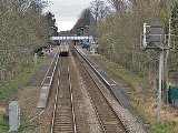
The station has two platforms, one for northbound services (platform 1) and the other for southbound services (platform 2), with a footbridge crossing the line connecting the two platforms. The platform shelters were replaced and electronic information displays were installed in the spring of 2011. There are two small areas for car parking/dropping off, on either side of the line — one can be accessed from Sandford Avenue (the B4371), the other from Crossways (which comes off the A49A49 road
The A49 is a major road in western England, which traverses the Welsh Marches region. It runs north from Ross-on-Wye in Herefordshire via Hereford, Leominster, Ludlow, Shrewsbury and Whitchurch, then continues through central Cheshire to Warrington and Wigan before terminating at its junction with...
).
The station lies on the highest point of the line between Shrewsbury
Shrewsbury railway station
Shrewsbury railway station is the railway station serving Shrewsbury, county town of Shropshire, England. It is the only remaining railway station in the town; Shrewsbury Abbey, as well as other small stations around the town, having long closed. The station was built in 1848 and has been extended...
and Craven Arms
Craven Arms railway station
Craven Arms railway station serves the small town of Craven Arms in Shropshire, England. Until 1974 it was known as "Craven Arms and Stokesay", named after the nearby coaching inn and the historic settlement of Stokesay to the south...
, and is the highest station in Shropshire. There is on the northbound platform a small plinth
Plinth
In architecture, a plinth is the base or platform upon which a column, pedestal, statue, monument or structure rests. Gottfried Semper's The Four Elements of Architecture posited that the plinth, the hearth, the roof, and the wall make up all of architectural theory. The plinth usually rests...
noting the station's altitude
Altitude
Altitude or height is defined based on the context in which it is used . As a general definition, altitude is a distance measurement, usually in the vertical or "up" direction, between a reference datum and a point or object. The reference datum also often varies according to the context...
: 613ft (187m) above sea level.
As of May 2011, trains call (Monday to Saturday) approximately one per hour, running between Cardiff Central
Cardiff central station
Cardiff Central Station can refer to:*Cardiff Central railway station*Cardiff central bus station...
(and other locations in south Wales) and Manchester Piccadilly (via Crewe
Crewe railway station
Crewe railway station was completed in 1837 and is one of the most historic railway stations in the world. Built in fields near to Crewe Hall, it originally served the village of Crewe with a population of just 70 residents...
) or Holyhead
Holyhead railway station
Holyhead railway station serves the town of Holyhead on Holy Island, Anglesey. It is the western terminus of the North Wales Coast Line and is managed by Arriva Trains Wales, although Virgin Trains also serves it....
(via Chester
Chester railway station
Chester railway station is a railway station in Newtown in the city of Chester, England. It is currently operated by Arriva Trains Wales, although Merseyrail, Northern Rail and Virgin Trains also run services from the station. It is situated to the north-east of the city centre...
). All trains calling at Church Stretton also call at Shrewsbury, immediately prior or after, which is a 15 minutes' journey. Not all trains operating on the Welsh Marches Line stop at Church Stretton. Services operate infrequently on Sundays, with very few trains before mid-afternoon. There are four trains a day (two on Sundays) in each direction along the Heart of Wales Line, of which all call at Church Stretton.
The station has a large number of passengers using it considering the town has a population of just 3000; it is the sixth most-used station in Shropshire (the fourth for the Shropshire Council
Shropshire Council
Shropshire Council is a unitary authority in Shropshire, United Kingdom.It replaced the former two-tier local government structure in the non-metropolitan county of Shropshire on 1 April 2009, which involved its immediate predecessor, Shropshire County Council, and five non-metropolitan districts -...
area). The high usage can be explained by two reasons: the town is a popular tourist destination and many of its inhabitants travel to Shrewsbury and Ludlow for employment, education and shopping.
The station has been "adopted" by local volunteers and is regularly kept tidy by them, including the garden areas behind both platforms. In 2011 a tree sculpture depicting two owls was carved by David Bytheway.
Infrastructure
The track through the station is prone to flooding when heavy rain occurs as, although at the apex of the line, it is at the bottom of the valleyValley
In geology, a valley or dale is a depression with predominant extent in one direction. A very deep river valley may be called a canyon or gorge.The terms U-shaped and V-shaped are descriptive terms of geography to characterize the form of valleys...
which Church Stretton is found in. (Church Stretton effectively lies at a saddle point
Saddle point
In mathematics, a saddle point is a point in the domain of a function that is a stationary point but not a local extremum. The name derives from the fact that in two dimensions the surface resembles a saddle that curves up in one direction, and curves down in a different direction...
.) At one stage during the infamously wet autumn of 2000, the space between the two platforms resembled a canal
Canal
Canals are man-made channels for water. There are two types of canal:#Waterways: navigable transportation canals used for carrying ships and boats shipping goods and conveying people, further subdivided into two kinds:...
and train services had to be cancelled along the line.
Following the serious flooding of the railway line in 2000, the signal box
Signal box
On a rail transport system, signalling control is the process by which control is exercised over train movements by way of railway signals and block systems to ensure that trains operate safely, over the correct route and to the proper timetable...
at Church Stretton (which was situated to the north of the Sandford Avenue bridge) was "switched out". The signal box at Church Stretton closed entirely in 2004 and the set of points
Railroad switch
A railroad switch, turnout or [set of] points is a mechanical installation enabling railway trains to be guided from one track to another at a railway junction....
at the station lay defunct for a number of years and were removed in 2009, together with the box (built 1872) and all signals. The control of the line here has been transferred to Marsh Brook
Marshbrook
Marshbrook is a hamlet in Shropshire, England. It is sometimes spelt "Marsh Brook", which is also the name of a small watercourse which flows through the area....
signal box, which is to the south.
Bus connections
Church Stretton is served by the 435 bus route (the Shrewsbury-Ludlow service), run by Minsterley MotorsMinsterley Motors
Minsterley Motors is a bus operator and limited company based in Minsterley, Shropshire, England.The company's main operations concentrate on stage service and schools contract work for Shropshire County Council...
, which runs Monday-Saturday. This connects the town with some nearby villages including All Stretton
All Stretton
All Stretton is a village and civil parish in Shropshire, England.-Geography:All Stretton lies about a mile to the north of the market town of Church Stretton, on the old Shrewsbury Road - the county town is 12 miles to the north. Similarly, the small village of Little Stretton lies to the south...
, Dorrington
Dorrington, Shropshire
Dorrington is a large village in Shropshire, England, located 6 miles south of Shrewsbury. The population of the village was estimated as being 619 in 2008....
, Leebotwood
Leebotwood
Leebotwood is a village and parish in Shropshire, England.It is located on the A49 road, north of Church Stretton and south of Dorrington. The village of All Stretton is 2 miles away....
, Little Stretton
Little Stretton, Shropshire
Little Stretton is a village in Shropshire, England.It lies on the B5477 to the south of the town of Church Stretton ; similarly, the small village of All Stretton lies to the north of Church Stretton on the same road...
and Marshbrook
Marshbrook
Marshbrook is a hamlet in Shropshire, England. It is sometimes spelt "Marsh Brook", which is also the name of a small watercourse which flows through the area....
. In addition there is a Shropshire Hills Shuttles service (route 780) that operates during the spring/summer, which runs over the Long Mynd
Long Mynd
The Long Mynd in Shropshire, England, is a part of the Shropshire Hills Area of Outstanding Natural Beauty. It is south of the county town Shrewsbury, and has an area of over 22 square kilometres , most of which takes the form of a heathland plateau. Most of the land on the Long Mynd is owned by...
to Ratlinghope
Ratlinghope
Ratlinghope is a village and civil parish in Shropshire, England. It is situated four miles west from Church Stretton and twelve miles south from Shrewsbury.Historically it is located in the hundred of Purslow...
& Bridges, Stiperstones
Stiperstones
The Stiperstones is a very distinctive hill in the county of Shropshire, England. It is a quartzite ridge formed some 480 Million years ago. During the last Ice Age the summit stood out above the glaciers and was subject to constant freezing and thawing which shattered the quartzite into a mass of...
, Habberley
Habberley, Shropshire
Habberley is a small village in the English county of Shropshire.Habberley lies near the Stiperstones southwest of the town of Shrewsbury.Formerly a small civil parish in its own right Habberley was merged in to the Pontesbury civil parish in 1967. In 1824 its population was recorded as 151 - by...
and Pulverbatch. This operates at the weekends and on Bank Holiday
Bank Holiday
A bank holiday is a public holiday in the United Kingdom or a colloquialism for public holiday in Ireland. There is no automatic right to time off on these days, although the majority of the population is granted time off work or extra pay for working on these days, depending on their contract...
Mondays. Bus services run to and from Beaumont Road, 275 metre from the station .