
Cound Brook
Encyclopedia
Cound Brook is a tributary
of the River Severn
in Shropshire
, England
, running to south of the county town Shrewsbury
. The Cound Brook rises in the Stretton Hills
and discharges into the River Severn at Eyton on Severn
after winding its way for 25 miles (40.2 km) across the southern Shropshire-Severn plains.
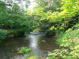
The flow of the Cound Brook can vary from sluggish in a dry summer to a raging torrent in winter or spring. The river is crossed by several bridges along its route including two historic and unusual iron bridges. Several other roads cross the river as fords. The river has breached its banks on the lower flood plain several times in the past and is now monitored by the local rivers authority.
The river is named after Cound
, the last settlement it passes through prior to the confluence with the River Severn. Conversely one of the villages on its route, Condover
, is thought to be have been named after the river during the late medieval period.
The Coundmoor Brook is a smaller watercourse which flows into the Cound Brook near its confluence with the Severn at Cound.
and Caer Caradoc in the northern part of the "Stretton Gap", between the settlements of Church Stretton
and All Stretton
. One of the initial tributaries is the stream that runs through the Carding Mill Valley, which is named "Ashbrook" as it flows through Church Stretton. The embryonic river descends towards the Shropshire-Severn plain and heads north east mirroring the route of the A49
main road and the Shrewsbury to Hereford railway line.
and the Medieval deer park
there. Continuing to the east of Dorrington
village, at Stapleton the Cound changes direction and heads eastwards.
The Cound passes through the historic and picturesque Condover
with its conservation area
and many Listed buildings. A water mill was recorded as standing on the Cound in Condover at the time of the Domesday Book
. After Condover the river heads south east through Boreton.
there is an unusual cast iron
single span bridge known as the Cantlop Bridge
, that was designed and constructed by Thomas Telford
in 1820. Originally a road bridge to cross the Cound Brook, it now remains only as a historic monument as the original 19th century road route is now diverted alongside on a modern bridge. A small layby nearby allows access by the public and the bridge is maintained by English Heritage
.
The river then passes through the village of Cound
and under another iron bridge, the Coundarbour bridge, also designed and built by Telford, the oldest iron bridge still in normal every day use anywhere in the world and built in 1797. Telford's famous Iron Bridge
had closed to vehicular traffic in 1934 and is now only open to pedestrians for a few hours each day.
and less than a mile south from Wroxeter
(with its Roman city ruins), close to the northern end of the Watling Street
Roman road from Dover
.
Tributary
A tributary or affluent is a stream or river that flows into a main stem river or a lake. A tributary does not flow directly into a sea or ocean...
of the River Severn
River Severn
The River Severn is the longest river in Great Britain, at about , but the second longest on the British Isles, behind the River Shannon. It rises at an altitude of on Plynlimon, Ceredigion near Llanidloes, Powys, in the Cambrian Mountains of mid Wales...
in Shropshire
Shropshire
Shropshire is a county in the West Midlands region of England. For Eurostat purposes, the county is a NUTS 3 region and is one of four counties or unitary districts that comprise the "Shropshire and Staffordshire" NUTS 2 region. It borders Wales to the west...
, England
England
England is a country that is part of the United Kingdom. It shares land borders with Scotland to the north and Wales to the west; the Irish Sea is to the north west, the Celtic Sea to the south west, with the North Sea to the east and the English Channel to the south separating it from continental...
, running to south of the county town Shrewsbury
Shrewsbury
Shrewsbury is the county town of Shropshire, in the West Midlands region of England. Lying on the River Severn, it is a civil parish home to some 70,000 inhabitants, and is the primary settlement and headquarters of Shropshire Council...
. The Cound Brook rises in the Stretton Hills
Shropshire Hills AONB
The Shropshire Hills area is designated as an Area of Outstanding Natural Beauty , in the English county of Shropshire, close to its border with Wales. Designated in 1958 , the area encompasses of land primarily in south-west Shropshire...
and discharges into the River Severn at Eyton on Severn
Eyton on Severn
Eyton on Severn is a small village in the English county of Shropshire. It is located on a ridge above the northern bank of the River Severn. The significant tributory of the Cound Brook joins the Severn at Eyton, albeit on the opposite bank....
after winding its way for 25 miles (40.2 km) across the southern Shropshire-Severn plains.
The flow of the Cound Brook can vary from sluggish in a dry summer to a raging torrent in winter or spring. The river is crossed by several bridges along its route including two historic and unusual iron bridges. Several other roads cross the river as fords. The river has breached its banks on the lower flood plain several times in the past and is now monitored by the local rivers authority.
The river is named after Cound
Cound
Cound is a village and civil parish on the west bank of the River Severn in the English county of Shropshire, 6.7 miles south east of the county town Shrewsbury...
, the last settlement it passes through prior to the confluence with the River Severn. Conversely one of the villages on its route, Condover
Condover
Condover is a village and civil parish in Shropshire, England. It lies 4.7 miles south of the county town of Shrewsbury, and just east of the A49. The Cound Brook flows through the village on its way from the Stretton Hills to a confluence with the River Severn...
, is thought to be have been named after the river during the late medieval period.
The Coundmoor Brook is a smaller watercourse which flows into the Cound Brook near its confluence with the Severn at Cound.
Source
The Cound rises from minor watercourses running off the Long MyndLong Mynd
The Long Mynd in Shropshire, England, is a part of the Shropshire Hills Area of Outstanding Natural Beauty. It is south of the county town Shrewsbury, and has an area of over 22 square kilometres , most of which takes the form of a heathland plateau. Most of the land on the Long Mynd is owned by...
and Caer Caradoc in the northern part of the "Stretton Gap", between the settlements of Church Stretton
Church Stretton
Church Stretton is a small town and civil parish in Shropshire, England. The population of the town was recorded as 2,789 in 2001, whilst the population of the wider parish was recorded as 4,186...
and All Stretton
All Stretton
All Stretton is a village and civil parish in Shropshire, England.-Geography:All Stretton lies about a mile to the north of the market town of Church Stretton, on the old Shrewsbury Road - the county town is 12 miles to the north. Similarly, the small village of Little Stretton lies to the south...
. One of the initial tributaries is the stream that runs through the Carding Mill Valley, which is named "Ashbrook" as it flows through Church Stretton. The embryonic river descends towards the Shropshire-Severn plain and heads north east mirroring the route of the A49
A49 road
The A49 is a major road in western England, which traverses the Welsh Marches region. It runs north from Ross-on-Wye in Herefordshire via Hereford, Leominster, Ludlow, Shrewsbury and Whitchurch, then continues through central Cheshire to Warrington and Wigan before terminating at its junction with...
main road and the Shrewsbury to Hereford railway line.
Middle route
With the rainwater runoff from the Stretton Hills the brook rapidly widens to a significant flow, passing to the east of Leebotwood and west of LongnorLongnor, Shropshire
Longnor is a village and civil parish in the English county of Shropshire.It is located just off the A49 south of Dorrington and north of Leebotwood...
and the Medieval deer park
Medieval deer park
A medieval deer park was an enclosed area containing deer. It was bounded by a ditch and bank with a wooden park pale on top of the bank. The ditch was typically on the inside, thus allowing deer to enter the park but preventing them from leaving.-History:...
there. Continuing to the east of Dorrington
Dorrington, Shropshire
Dorrington is a large village in Shropshire, England, located 6 miles south of Shrewsbury. The population of the village was estimated as being 619 in 2008....
village, at Stapleton the Cound changes direction and heads eastwards.
The Cound passes through the historic and picturesque Condover
Condover
Condover is a village and civil parish in Shropshire, England. It lies 4.7 miles south of the county town of Shrewsbury, and just east of the A49. The Cound Brook flows through the village on its way from the Stretton Hills to a confluence with the River Severn...
with its conservation area
Conservation area
A conservation areas is a tract of land that has been awarded protected status in order to ensure that natural features, cultural heritage or biota are safeguarded...
and many Listed buildings. A water mill was recorded as standing on the Cound in Condover at the time of the Domesday Book
Domesday Book
Domesday Book , now held at The National Archives, Kew, Richmond upon Thames in South West London, is the record of the great survey of much of England and parts of Wales completed in 1086...
. After Condover the river heads south east through Boreton.
Iron bridges
To the north of the village of CantlopCantlop
Cantlop is a small village in the English county of Shropshire. It is part of the civil parish of Berrington. Various meanings have been suggested for the name, such as an enclosed or cut-off valley or an enclosure in a waste or common....
there is an unusual cast iron
Cast iron
Cast iron is derived from pig iron, and while it usually refers to gray iron, it also identifies a large group of ferrous alloys which solidify with a eutectic. The color of a fractured surface can be used to identify an alloy. White cast iron is named after its white surface when fractured, due...
single span bridge known as the Cantlop Bridge
Cantlop Bridge
Cantlop Bridge is a single span cast-iron road bridge over Cound Brook in the parish of Berrington, Shropshire. It was constructed in 1818 to a design possibly by Thomas Telford, being at least having been approved by him, and replaced an unsuccessful cast iron coach bridge constructed in 1812...
, that was designed and constructed by Thomas Telford
Thomas Telford
Thomas Telford FRS, FRSE was a Scottish civil engineer, architect and stonemason, and a noted road, bridge and canal builder.-Early career:...
in 1820. Originally a road bridge to cross the Cound Brook, it now remains only as a historic monument as the original 19th century road route is now diverted alongside on a modern bridge. A small layby nearby allows access by the public and the bridge is maintained by English Heritage
English Heritage
English Heritage . is an executive non-departmental public body of the British Government sponsored by the Department for Culture, Media and Sport...
.
The river then passes through the village of Cound
Cound
Cound is a village and civil parish on the west bank of the River Severn in the English county of Shropshire, 6.7 miles south east of the county town Shrewsbury...
and under another iron bridge, the Coundarbour bridge, also designed and built by Telford, the oldest iron bridge still in normal every day use anywhere in the world and built in 1797. Telford's famous Iron Bridge
The Iron Bridge
The Iron Bridge crosses the River Severn at the Ironbridge Gorge, by the village of Ironbridge, in Shropshire, England. It was the first arch bridge in the world to be made out of cast iron, a material which was previously far too expensive to use for large structures...
had closed to vehicular traffic in 1934 and is now only open to pedestrians for a few hours each day.
Discharge
The Cound Brook now follows an increasingly meandering route across a low lying flood plain until it discharges into the River Severn a few hundred yards west of Eyton on SevernEyton on Severn
Eyton on Severn is a small village in the English county of Shropshire. It is located on a ridge above the northern bank of the River Severn. The significant tributory of the Cound Brook joins the Severn at Eyton, albeit on the opposite bank....
and less than a mile south from Wroxeter
Wroxeter
Wroxeter is a village in Shropshire, England. It forms part of the civil parish of Wroxeter and Uppington and is located in the Severn Valley about south-east of Shrewsbury.-History:...
(with its Roman city ruins), close to the northern end of the Watling Street
Watling Street
Watling Street is the name given to an ancient trackway in England and Wales that was first used by the Britons mainly between the modern cities of Canterbury and St Albans. The Romans later paved the route, part of which is identified on the Antonine Itinerary as Iter III: "Item a Londinio ad...
Roman road from Dover
Dover
Dover is a town and major ferry port in the home county of Kent, in South East England. It faces France across the narrowest part of the English Channel, and lies south-east of Canterbury; east of Kent's administrative capital Maidstone; and north-east along the coastline from Dungeness and Hastings...
.